1. New Jersey history for sale
NorthCape
May
Sandy Hook
Husdon River
Delaware River
New Jersey
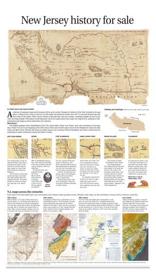
Getting your bearings: North is to the right, west is at the top
While
the map
is in good shape
overall, this edge is
badly damaged
JUST PLAIN WRONG FORT ELSINBURGHRIVERS SANDY (HOOK) POINT INDIAN VILLAGES PLAGIARISM
One of New Jersey’s most rec-
ognized features, Cape May, is
pictured as an island. It was
named for Cornelius May (or
Mey), leader of a short-lived
Dutch settlement along the
Delaware.
The shoreline in those days
would have been less stable,
with fewer jettied inlets and
dredged channels. The barrier
islands can shift and change,
but Cape May as an island?
No.
The only colonial fortification
shown in New Jersey. The
Dutch had built several forts in
New Netherlands for protection
not only from the Indians, but
from the other colonial powers.
Another example was Fort
Nassau, also on the Delaware;
it was built by the settlers
under Cornelius May.
Going through many varia-
tions, Elsinburgh’s name has
survived as Elsinboro Township
in Salem County.
With no established road sys-
tem, rivers were the highways
of the day. A reliable map was
vital for shipping, trade and
settlement.
The Maurice River was
originally named
the Prince
Maurice River.
Prince Maurice
of Orange
(1567-1625) was
a Dutch hero in
the war against
the Spanish.
Quite clearly not a hook. This
is one geographical feature
that has continued to change
over time. Sometimes an
island, its shape has shifted
constantly and these changes
are reflected in the maps of
the day.
An important landmark for
mariners, the idea of a light-
house there goes back to
1679. But the famous Sandy
Hook Lighthouse was not built
until 1761.
“The manner of Indian
Fortifications Town Houses
and Dwelling places”
The Lenape were still the dom-
inant people in the state late
into the 17th century. The
stockades shown were a very
common element on Dutch
and English maps. Houses are
pictured along the southern
Delaware River and may desig-
nate settlements. Two tribal
names appear, “Tappaans” and
“Waranawankongs.”
As impressive as Seller’s map
is, the basic information on it
was taken from earlier maps.
Without copyright laws, map-
makers regularly stole from
each other into the 19th cen-
truy. Even the animals were
copied from an earlier print.
collection of important maps and documents will be up for auction Tuesday at Christie’s in New York. Included is the map
above. A Mapp of New Jersey in America, by John Seller, was printed in London circa 1677. It is the first printed map with
New Jersey as the subject. While several versions of this map exist, this one is unique, containing changes not seen in any
other surviving example. Printmakers would frequently rework the copper plates these maps were engraved on, updating or elim-
inating lines and images as better information was collected.
New Jarsey?
The English language wasn’t standardized in the 17th century. Both “Jarsey” and “Jersey” were used, sometimes on the same
map. “Jersey” won out in the beginning of the 18th century. This is also the first map to show the line dividing the colony into East
Jersey and West Jersey. This line still exists on modern maps as the boundary between Burlington and Ocean counties and the
southwestern border of Somerset County with Mercer County.
A
Prince
Maurice
Bears from a map by
Willem Blaeu, 1635
SOURCES: “The Mapping of New Jersey” by John P. Snyder; professor Karl Nordstrom at the Institute of Marine and Coastal Sciences at Rutgers; Chris Coover, senior specialist in books and manuscripts, Christie’s; National Park Service; Rutgers University Libraries Special Collections;
NASA; Library of Congress; “The Lenape-Delaware Indian Heritage” by Herbert C. Kraft
CHRISTIE’S
18th century
William Faden’s 1777 map of New Jersey and a
second edition in 1778 (below) were based on a
1769 survey produced by a British cartographer.
This map was a large step forward, and generally
accurate, with no location error greater than 12
miles. Many county boundary changes, some up
to 20 years old, were not reflected on this map.
19th century
Cartography shifted from an interpretive art to a
mathematical science. The first largely accurate
map of New Jersey was produced by Thomas
Gordon for the state in 1828, and was accurate to
within three quarters of a mile. George Hammell
Cook created the first complete geologic map
below. It was printed in 1889.
20th century
The rise of the automobile gave cartographers a new
goal, the road map. Advances in available government
surveys and reproduction made it cheaper to produce maps
than ever. Convent Station-based General Drafting Co. teamed
up with Standard Oil in 1923 to start the trend of free road
maps at gas stations. Below is a 1951 map of the new New
Jersey Turnpike.
21st century
Global positioning systems, computer-
ized mapping and satellite imagery are
creating maps with more accuracy
than ever. The image shown below was
captured by NASA’s Terra satellite in
fall 2003, and was made available for
free on the Internet within hours.
N.J. maps across the centuries
Early maps of the New World were rare commodities that showed closely guarded secrets. Detailed maps today are free worldwide to anyone with an Internet connection.
BY FRANK CECALA AND HASSAN HODGES