ASSESSMENT OF VEGETATION COVER USING UAV-BASED REMOTE SENSING
PG&E Tech Article UAN Feb2015
1. It is amazing to think how far tech-
nology has come in so little time.
Ten years ago, there were different
devices for different functions, and
virtually all of them were single serv-
ing. If you are a “gadget person” you
probably had an mp3 player, two flip
phones (one personal and one for
work), a GPS device, and possibly
even a three-inch thick laptop to ef-
fectively answer your e-mail while in
the field. Nowadays, a single Smart-
phone can satisfy all of those needs.
Unfortunately, the utility vegeta-
tion management (UVM) industry has
been slow to adopt such innovative
progress. Hampered by schedule at-
tainment issues and insufficient
budgets, vegetation managers have
little time to consider enhancing
their programs with emerging tech-
nologies. As a result, some are
forced to use spreadsheets to track
their tree inventory and paper to
track everything else.
Pacific Gas and Electric Company’s
(PG&E) Vegetation Management pro-
gram has historically been very pro-
gressive with its use of technology.
However, after the North America
Electric Reliability Corporation (NERC)
issued what is now known as the
“NERC Alert of 2010,” PG&E was intro-
duced to LiDAR (Light Detection and
Ranging) technology, which is now re-
defining how PG&E approaches UVM.
Innovation and Technology at PG&E
It is estimated that there are 50
million trees adjacent to PG&E’s
134,000 miles of overhead transmis-
sion and distribution lines. Each year,
vegetation management contractors
inspect every inch of PG&E’s over-
head conductors on foot and issue
work on roughly 1.5 million trees.
Put another way, PG&E contractors
walk the equivalent of five and half
times around the earth to ensure
PG&E is in compliance with all State
and Federal regulations. With this
perspective, it makes sense to
consider new technology as a means
of increasing the accuracy and effi-
ciency of vegetation patrols.
Since 2010, PG&E has leveraged
LiDAR data to supplement a portion
of its transmission line vegetation
patrols and the results have been im-
pressive. PG&E’s current LiDAR ven-
dor provides a detailed picture of all
trees and clearances along transmis-
sion line corridors with three-cen-
timeter accuracy, automatically
identifying locations where trees
may be “grow-in” and “fall-in”
threats. Using the LiDAR data, PG&E
contractors can then expedite their
surveys by reducing the manual in-
spection portion of their patrols.
The accuracy of LiDAR compared
to traditional manual inspections al-
lows PG&E to more efficiently use its
resources by pruning or removing
only the trees that are truly threats.
In one example, the PG&E transmis-
sion team compared a LiDAR survey
to a traditional manual inspection
and found that a few thousand trees
listed during the manual inspection
did not need work. This resulted in a
more accurate accounting of neces-
sary tree work and a better use of
valuable resources.
Similar to the ubiquity and com-
moditization of the Smartphone, LiDAR
is being used more routinely by trans-
mission line owners for vegetation
and maintenance inspections. LiDAR
is just the tip of the iceberg though;
vegetation managers can acquire
much more information with further
data and imagery analysis.
Expanding the Scope of Remote
Sensing
Remote sensing is the act of ac-
quiring information about an object
remotely; examples of technologies
used to accomplish this include
LiDAR, photogrammetry, and spectral
imagery. In October 2014, PG&E con-
cluded a remote sensing initiative to
assess tree canopy health and tree
fall-in risk along 12,000 miles of
PG&E distribution line. The initiative
was part of a larger four-month proj-
ect aimed at reducing the risk of
wildfire in response to the California
Drought State of Emergency. The re-
mote sensing initiative sought to use
LiDAR and photogrammetry to iden-
tify areas where trees are tall
enough to strike PG&E facilities, and
spectral imagery to identify the rela-
tive health of tree canopies in addi-
tion to species identification.
LiDAR, Photogrammetry, and Spec-
tral Imagery
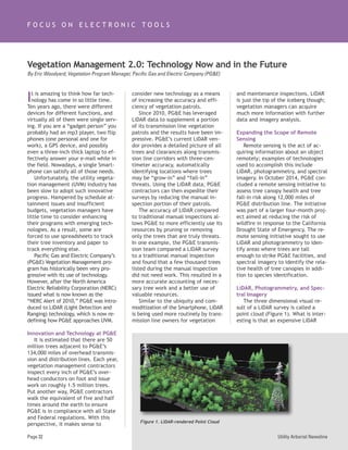
The three dimensional visual re-
sult of a LiDAR survey is called a
point cloud (Figure 1). What is inter-
esting is that an expensive LiDAR
Page 32
Vegetation Management 2.0: Technology Now and in the Future
By Eric Woodyard, Vegetation Program Manager, Pacific Gas and Electric Company (PG&E)
F O C U S O N E L E C T R O N I C T O O L S
Figure 1. LiDAR-rendered Point Cloud
Utility Arborist Newsline
2. sensor is not necessarily needed to
create a point cloud. Two-dimen-
sional aerial photographs can be
processed such that the end result is
a photogrammetric point cloud with
similar accuracy to that of a LiDAR-
rendered point cloud.
During PG&E’s remote sensing ini-
tiative, mobile LiDAR, aerial LiDAR
and photogrammetry were used in
different geographic regions to lo-
cate distribution pole and wire as-
sets, and to acquire general tree
information such as height and quan-
tity. In addition to the point cloud-
derived information, orthoimagery
was analyzed to detect dead or dying
vegetation using the near infrared
band available in the four-band or-
thoimagery.
Lastly, computer vision and ma-
chine learning were used to analyze
four-band NAIP (National Agriculture
Imagery Program) imagery to identify
the tree species of gray pine (this
species was chosen due to its distinct
gray color relative to other vegeta-
tion). This process, called species ex-
traction, geospatially located sites
where the computer detected poten-
tial gray pine canopies (Figure 2).
This information was then fused with
the LiDAR data to filter out any false
positives.
The final deliverables provided
PG&E with an accurate geospatial
layer of distribution poles, an “as
modeled” layer showing the general
location of the conductors, and poly-
gon layers signifying different tree
“detections” (Figure 3). With these
data layers residing in “the cloud,”
PG&E inspection contractors have
access to the data on a tablet, and
use the tablet to locate and verify
the detections in the field.
Future Tools and Technology
The remote sensing initiative has
proven to be a very promising proof-
of-concept. PG&E’s next step is to
research the following tools and
technologies to build upon what has
been learned:
Hyperspectral Imagery
Hyperspectral imagery (HSI) goes
well beyond the analysis of four-
band imagery by analyzing informa-
tion from across the electromagnetic
spectrum. HSI can determine the
unique spectral signature of an ob-
ject based on how the object ab-
sorbs and reflects light at different
wavelengths. By identifying the
spectral signature of a tree species,
a broader HSI survey can be used to
remotely identify each location
where the subject tree species exists
within the surveyed region. Addi-
tional applications of this type of im-
agery analysis can be used to detect
issues with conductors or equipment
that cannot be seen with the naked
eye.
Satellite Imagery
Today’s commercial satellite
imagery offers ample opportunity for
any land or vegetation manager. One
California startup has begun
launching a constellation of satellites
that will soon provide images from
anywhere on Earth at any time of
the day. Another imagery firm can
provide high definition video from
space while a third offers high-
resolution satellite imagery for
detailed analysis.
Along with monitoring tree canopy
health from space, vegetation man-
agers will have the ability to develop
a photogrammetric point cloud from
satellite imagery. Keep in mind,
present-day commercial satellite im-
agery will not yield an engineering-
grade point cloud; however, for the
purposes of detecting changes in a
right-of-way or measuring vegetation
with one foot accuracy, satellite im-
agery is definitely a viable possibil-
ity. Using satellite imagery, any
vegetation manager would be able to
acquire information more frequently
in a much safer manner and at a dis-
count to fixed-wing or helicopter ac-
quisition costs.
Unmanned Aerial System (UAS)
One cannot talk about any type of
utility maintenance inspections for
long without bringing up the topic of
“drones,” or as the Federal Aviation
Administration (FAA) refers to them,
UASs. It goes without saying that
January–February 2015
Figure 2. Gray Pine Polygons Along a PG&E Distribution Line (orange line)
Figure 3. Tree Detections Identified with LiDAR and Spectral Imagery
Page 33
3. Utility Arborist NewslinePage 34
Name: ________________________________________________________
Company: ______________________________________________________
Address:________________________________________________________
City, State & Zip: ________________________________________________
Sponsor (if applicable): __________________________________________
Bus. Phone: ____________________________________________________
Home Phone:____________________________________________________
Fax: __________________________________________________________
Email:__________________________________________________________
CHECK ONE: c Business address
c Home address
CHECK ONE: c Membership Renewal
c New Member
c Address change/correction
CHECK ONE: c Electric Utility Employee
c Contractor Service Employee
c Materials/Chemical Supplier
c Academia/Research
c Other
Dues may be paid by cash, check or credit card.
Please check one of the following:
c Visa
c MasterCard
c American Express
Name on Card___________________________________________________
Card Number____________________________________________________
Exp Date: ______________________________________________________
DUES FOR 1 YEAR ARE $40.00 USD.
Send completed form with your check (US Funds drawn on a US bank)
payable to Utility Arborist Association and mail to:
UAA
PO Box 3129
Champaign, IL 61826-3129
or fax with credit card information to (217) 355-9516.
UTILITY ARBORIST ASSOCIATION APPLICATION 2014-2015
4. January–February 2015 Page 35
there is serious potential for the UAS
to be a game changer for electric
utilities. It is believed that by adopt-
ing a UAS fleet for inspection pur-
poses, data acquisition costs could
be reduced by 70 percent initially
and by 80 to 90 percent after a few
years (compared to traditional LiDAR
acquisition costs). If this is accurate,
the electric utility industry could ac-
quire LiDAR and other imagery every
year on 100 percent of the grid at a
fraction of today’s costs. This para-
digm shift could allow for multi-year
vegetation maintenance cycles to
convert to annual patrols, which
would benefit customers by improv-
ing public safety and reliability while
more efficiently using maintenance
resources.
Vegetation Management 2.0
When most people think about in-
novation and technology, they proba-
bly visualize a newer, smaller, faster
version of something they already
have. In most cases this is true but
vegetation managers should not
think this way. We should not try to
fold a new technology into what is
already being used. We should em-
brace the new technology and under-
stand that it has the ability to
redefine how utilities manage their
assets and replace the old way of
operating.
Satellite imagery will detect
changes in tree health and alert veg-
etation managers to problem areas
before trees begin to fail onto criti-
cal assets. Broken cross arms and
annealed wire will be identified
along with vegetation encroach-
ments during aerial remote sensing
missions. Mobile LiDAR will survey a
neighborhood for vegetation while
gathering information on conductor
heights for asset managers. Simulta-
neously, additional mobile sensors
will perform infrared patrols on
overhead conductors and sniff for
natural gas leaks. The end result of
this integrated survey will yield an
information rich, three-dimensional
environment for all internal utility
stakeholders.
The economies of scale of this
type of informational environment
will be truly revolutionary. It is
worth noting that most of what the
“future patrol” describes above can
be done now. PG&E’s Vegetation
Management team understands the
game-changing potential that this
technology offers and is evaluating
how to integrate several overhead
maintenance patrols into a single pa-
trol. Working together, multiple lines
of business could complete all in-
spections at once. For PG&E, this
will lead to one inspection. More im-
portantly for our customers, it will
lead to One PG&E that offers safe,
affordable, and reliable service.
F O C U S O N E L E C T R O N I C T O O L S
The Software Platform for Intelligent
Vegetation Management
Cycle Management. Herbicides.
Invoicing. Compliance. Utilities today
operate complex vegetation programs
information management tools. Clearion
offers an integrated suite of applications
for the entire operation, from managers
to arborists to crews to auditors. To see
how intelligent vegetation management
can work for you, contact us at
info@clearion.com.
www.clearion.com