1. Paleostress of Fracture Systems along the Niagara
Escarpment, Oakfield Ledge State Natural Area
Elizabeth
Borucki,
Michael
Defenbaugh,
William
Meier,
Jared
Miller
Structural
Geology,
2014
SeBng
and
IntroducDon
Along
eastern
Wisconsin,
stretching
from
Door
County
to
Dodge
County,
there
is
a
complex
geologic
feature
consis:ng
of
a
discon:nuous
series
of
raised
and
exposed
bedrock
(Newport
1962).
This
feature
formed
due
to
the
strength
of
the
Niagara
dolomite,
causing
preferen:al
erosion
of
the
underlying
Manquoketa
shale.
A
ridge
of
bedrock
known
as
the
Niagara
escarpment
was
exposed
(Dietrich
1994).
The
dolomite
visible
at
the
escarpment
features
many
fractures
and
faults
that
can
provide
key
indicators
of
the
paleostresses
(La
Pointe
et
al.
1985)
that
were
likely
linked
to
the
subsidence
of
the
Michigan
Basin
and
the
upliP
of
the
Wisconsin
Arch
(Luczaj
2013).
La
Pointe
et
al.
(1985)
claims
that
the
orienta:ons
of
regional
join:ng
remains
fairly
consistent
throughout
the
Niagara
dolomite
in
Wisconsin,
with
two
primary
sets
that
are
close
to
ver:cal:
one
strikes
approximately
330;
the
other
strikes
between
045
and
070.
Our
study
measured
the
aYtudes
of
extensional
fractures
on
an
exposed
por:on
of
the
Niagara
escarpment
at
Oakfield
Ledge
State
Natural
Area
in
Fond
du
Lac
County,
Wisconsin.
The
objec:ve
of
this
study
is
to
analyze
these
orienta:ons
in
comparison
to
those
predicted
by
La
Pointe
and
to
make
any
possible
interpreta:ons
of
regional
paleostress
orienta:ons.
Our
field
work
u:lized
a
Brunton
Compass
to
obtain
strike
and
dip
measurements
of
the
ver:cal
fractures.
The
fractures
measured
were
all
at
least
one
meter
in
length.
Fractures
exhibi:ng
a
great
deal
of
weathering
were
not
measured
as
erosion
and
frost
wedging
were
confounding
factors
at
the
field
site.
Another
qualifica:on
for
the
fractures
required
that
they
existed
as
part
of
the
main
cliff
wall
of
the
escarpment
since
many
larger
blocks
had
broken
off
from
the
main
ledge
and
shiPed
from
their
original
orienta:on.
Upon
comple:ng
our
field
work
we
then
u:lized
stereo-‐nets
to
interpret
if
there
were
any
clusters
of
measurements
and
to
break
down
the
direc:ons
of
paleostress.
Methodology
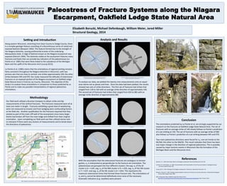
Fig
1:
Topographic
map
showing
the
drama:c
change
in
eleva:on
at
the
ridge.
From
Wisconsin
DNR.
Analysis
and
Results
Fig.
9:
Ver:cal
extension
joint
with
a
8x11.5
clipboard
for
scale.
Fig.
10:
Ver:cal
extension
joint
with
a
Brunton
Compass
for
scale.
With
the
assump:on
that
the
extensional
fractures
are
analogous
to
tension
gashes,
σ3
is
interpreted
as
perpendicular
to
the
fracture
set
orienta:on.
The
paleostresses
are
grouped
into
four
different
clusters:
the
avg.
σ3
of
the
SE
cluster
is
6––>145,
avg.
σ3
of
the
NW
cluster
is
9––>335,
avg.
σ3
of
the
SW
cluster
is
7––>227,
and
avg.
σ3
of
the
NE
cluster
is
6––>054.
This
represents
the
maximum
extensional
stress
that
formed
these
fracture
sets.
The
orienta:ons
of
σ1
and
σ2
cannot
be
determined
defini:vely
since
none
of
the
necessary
kinema:c
indicators
(e.g.
styolites)
were
present.
To
analyze
our
data,
we
plofed
the
twenty-‐nine
measurements
onto
an
equal-‐
area
stereo-‐net
as
planes
and
lines.
Once
the
data
had
been
plofed,
the
results
showed
two
sets
of
strike
direc:ons.
The
first
set
of
fractures
had
strikes
that
ranged
from
118
to
164
with
an
average
strike
direc:on
of
approximately
140.
The
second
set
of
fractures
had
strikes
that
ranged
from
034
to
082
with
an
average
strike
direc:on
of
approximately
060.
References
Conclusion
The
orienta:ons
predicted
by
La
Pointe
et
al.
are
strongly
supported
by
our
research
on
the
fractures
at
Oakfield
Ledge
State
Natural
Area.
The
set
of
fractures
with
an
average
strike
of
140
closely
follows
La
Pointe’s
predic:on
of
a
set
striking
at
150.
The
set
of
fractures
with
an
average
strike
of
060
also
follows
La
Pointe’s
predic:on
of
a
set
striking
between
045
and
070.
Two
main
paleostress
direc:ons
were
found
for
σ3:
one
set
trends
to
the
NE/SW;
the
other
to
the
NW/SE.
This
result
indicates
that
there
has
been
one
major
change
in
the
direc:on
of
regional
paleostress.
This
is
possibly
caused
by
major
tectonic
events
in
Wisconsin
like
the
forma:on
of
the
Michigan
Basin
and
the
Wisconsin
Arch.
Dietrich,
R.
V.,
1994.
Rock
Chips:
What
is
the
Niagara
escarpment?
Rocks
&
Minerals
69,
191-‐195.
La
Point,
P.R.
and
Hudson,
J.A.
1985.
Characteriza:on
and
interpreta:on
of
rock
mass
joint
paferns.
Geological
Society
of
America
Special
Paper
199.
Luczaj,
John
A.,
2013.
Geology
of
the
Niagara
escarpment
in
Wisconsin.
Geoscience
Wisconsin
22.
Newport,
Thomas
G.,
1962.
Geology
and
groundwater
resources
of
Fond
du
Lac
County,
Wisconsin.
United
States
Geological
Survey
Water
Supply
Paper
1604.
DNR.
Topographic
Map:
Oakfield
Ledge
State
Natural
Area.
h:p://dnr.wi.gov/topic/lands/naturalareas/documents/topomaps/map190.pdf.
Web.
23
April,
2014.
Fig.
2:
Equal-‐area
stereo-‐net
represen:ng
the
strikes
and
dips
of
extensional
fractures
at
Oakfield
Ledge
State
Natural
Area.
Fig.
3:
Rose
diagram
represen:ng
that
there
is
a
small
sta:s:cal
variance
of
the
fracture
set
orienta:ons.
Fig.
5:
Graphical
representa:on
of
σ3
trends
and
plunges
for
fractures
striking
NE.
Fig.
7:
Graphical
representa:on
of
σ3
trends
and
plunges
for
fractures
striking
SE.
Fig.
4:
An
equal-‐angle
stereo-‐net
representa:on
of
fractures
striking
NE-‐SW.
Fig.
6:
An
equal-‐angle
stereo-‐net
representa:on
of
fractures
striking
NE-‐SW.
Fig.
8:
View
of
the
outcrop
showing
extensive
fracturing.
Fig.
11:
View
of
the
outcrop
showing
disconnected
dolomite
block
from
main
ledge.