Infographic community gis
•
0 likes•87 views

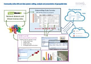
Online Geographic Information Systems - a system to use citizen science data and government data, download and edit it for specific projects, then present the information. New Zealand has a great deal of public information available for community groups to use.
Recommended

Recommended
More Related Content
Viewers also liked
Viewers also liked (8)
More from MAIN Trust NZ
Recently uploaded
Recently uploaded (20)
Infographic community gis
- 1. Community online GIS and data system: editing analysis and presentation of geospatial data National datasets and Citizen Science data data analysis NatureMap Data Service NZ species data for projects Cloud resources LINZ OBIS Koordinates NIWA LRIS Te Papa MfE GNS Public Private Combines resources and data in maps • Project specific maps • Editable maps • Specific data entry • PestMapper graphs and analysis MAIN Trust NZ Web maps: public or private