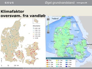
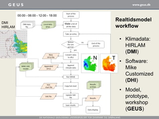
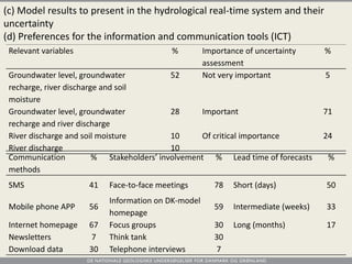
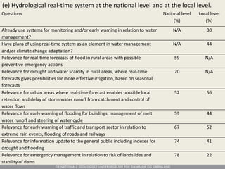
De Nationale Geologiske Undersøgelser for Danmark og Grønland
Ny realtids varslingsmodel til
forudsigelse af oversvømmelser
ved højt grundvandsniveau eller
vandindhold i rodzonen
Hans Jørgen Henriksen og He, Xin GEUS
IDA møde Nyborg 4. Februar 2016
• Hvorfor realtidsmodellering i det urbane rum?
• Den nationale hydrologiske model (DK model)
• Fire scenarier (national-lokal model)
• Undersøgelsesmetodik
• Resultater og feedback
• Konklusion
Indhold
• Samfundets behov for
hydrologisk realtids-
information er voksende
• WFD og oversvømmelses-
direktivet efterlyser en
integreret, oplands- og
helhedsorienteret tilgang
• DK-modellen som platform for
realtids modellering i urbane
rum og vandløbsoplande
• Stationariteten er død men
vandbalancen, hydrogeologien
og grundvands-overfladevands
interaktionen er breaking news
Hvorfor realtids
modellering i det
urbane rum?
Pejletids-
serier
Tinglevboringen:
www.tinglevboringen.dk
Brande:
kilde
JUPITER
19 Marts 2015
3 Feb 2015
Filtre:
4 m’s dybde (gul)
36 m’s dybde (blå)
Klimafaktor
oversvøm. fra vandløb
Øget grundvandstand
Kalibrering:
200 Q stat.
og
20.000 tryk-
niveau indtag
Diskretisering 500 m og 8-12 lag
Simulering af
trykniveau i
grundvand
Simulering af
jordfugtighed
Simulering af
vandføring i vandløb
(kalibreret og valideret for
2000-2011 ud fra historiske
klimadata; har aldrig været
anvendt til realtid/prognose
modellering)
Fire scenarier er undersøgt
i projektet Realtidsvarsling
Opdateret DK-model
Real tids simulering
seneste DMI klima data
Ren model
Ingen monitering
Ingen data assimilering
Simpel usikkerheds vurdering
DK-model prognose
Baseret på DMI vejr prognose
2-5 dages prognose
3-6 mdr. prognose
Ren model
Usikkerheds analyse/skill score
Ingen monitering / DA
Beslutningsværktøj
Simpelt styrings system
Kombination af
DK-model output
Moniterings data
Lokalt kendskab
Baysiansk net
Decision tree
Kompleks
lokal model
Kombination af
Detaljeret model
MIKE 11 / MIKE URBAN
DK-model output
Moniterings data
Data assimilering
Nationalt
niveau
Lokalt
niveau
Skjern å case study area / prototype
Henriksen, HJ, Stisen, S,
He, X and Wiese, MB 2015.
A hydrological early warning
system for Denmark based
on the national model.
Geological Survey of
Denmark and Greenland
Bulletin 33, 29-32
He, X, Stisen, S, Wiese, MB
and Henriksen, HJ
(accepted WARM)
Designing a hydrological
real-time system for surface
water and groundwater in
Denmark with engagement
of stakeholders.
Undersøgelses-
Metode:
• Prototype test
• Web baseret
spørgeskema
• Model
workshop
(vandmodel.dk/
realtidsvarsling)
Realtidsmodel
workflow
• Klimadata:
HIRLAM
(DMI)
• Software:
Mike
Customized
(DHI)
• Model,
prototype,
workshop
(GEUS)
DMI
HIRLAM
N T
00:00 - 06:00 - 12:00 - 18:00
Fra MIKE SHE simulering til website
Web interface for
Ahlergaarde
oplandet
15
Cloudburst 6-7
September
2014 hit Midt-
and Vestjylland
with hevy rain
locally more
than 50 mm
precipitation =>
flooding hazard
Workshop design
• Welcome and
presentation of early
warning system
prototype and web
interface for case study
area (GEUS)
• Partner presentations by
DHI and DMI of 20
years experiences with
early warning systems
• Three community based
early warning system
examples (Holstebro,
Fredensborg and Århus)
• Break out group session
and plenum
16
Relevance of a
national level
real-time
hydrological
model
describing the
actual water
state
Ability of the
national model
simulations to be
directly used as a
part of the local
water
management
Relevance of the
DK-model forecast
giving estimates of
hydrological
variables in the
future based on
weather forecasts
Ability of the
DK-model
forecast can be
used directly as
a part of the
local water
management
Low 14 15 20 16
Intermediate 29 46 40 42
High 57 39 40 42
Grid size % Temporal
discretization
% Frequency for
model refreshing
%
250 m 90 Minutes 12 Hours 27
500 m 10 Hours 23 Days 60
1000 m 0 Days 65 Months 13
(a) Relevance of hydrological real-time system at national scale.
(b) Desired hydrological model configuration
Relevant variables % Importance of uncertainty
assessment
%
Groundwater level, groundwater
recharge, river discharge and soil
moisture
52 Not very important 5
Groundwater level, groundwater
recharge and river discharge
28 Important 71
River discharge and soil moisture 10 Of critical importance 24
River discharge 10
Communication
methods
% Stakeholders’ involvement % Lead time of forecasts %
SMS 41 Face-to-face meetings 78 Short (days) 50
Mobile phone APP 56
Information on DK-model
homepage
59 Intermediate (weeks) 33
Internet homepage 67 Focus groups 30 Long (months) 17
Newsletters 7 Think tank 30
Download data 30 Telephone interviews 7
(c) Model results to present in the hydrological real-time system and their
uncertainty
(d) Preferences for the information and communication tools (ICT)
Questions National level
(%)
Local level
(%)
Already use systems for monitoring and/or early warning in relation to water
management?
N/A 30
Have plans of using real-time system as an element in water management
and/or climate change adaptation?
N/A 44
Relevance for real-time forecasts of flood in rural areas with possible
preventive emergency actions
59 N/A
Relevance for drought and water scarcity in rural areas, where real-time
forecasts gives possibilities for more effective irrigation, based on seasonal
forecasts
70 N/A
Relevance for urban areas where real-time forecast enables possible local
retention and delay of storm water runoff from catchment and control of
water flows
52 56
Relevance for early warning of flooding for buildings, management of melt
water runoff and steering of water cycle
59 44
Relevance for early warning of traffic and transport sector in relation to
extreme rain events, flooding of roads and railways
67 52
Relevance for information update to the general public including indexes for
drought and flooding
74 41
Relevance for emergency management in relation to risk of landslides and
stability of dams
78 22
(e) Hydrological real-time system at the national level and at the local level.
• National v.s. local systems
• Interaction between shallow groundwater aquifer
and surface water is a unique feature.
• Inconsistency in the understanding of time scale
between the surface water and groundwater
community.
• For future system development: (1) Model
uncertainty in the input data and the forecast;
(2) early warning schemes need to be developed
on top of hydrological forecasts; (3) agriculture
related issues need to be given more attention.
Feedback from the stakeholders
NORDRESS Odense case study
www.nordress.hi.is
(Kilde:
Johan Linderberg
Vandcenter Syd)
The evolution of Odense Oversvømmelses hotspots
Eksercermarken
TBT
Skibhus området
(infrastructure+community resilience)
Local decision support
(time-sliced bayesian networks: PhD study DTU Helena Åström 2015)
An influence diagram for urban flood risk assessment
through pluvial flood hazards under non-stationary
conditions Helena Åström, Peter Friis Hansen, Luca
Garré, Karsten Arnbjerg-Nielsen
Journal of Water and Climate, 5(3), 276-286 (2014)
Add resilience
and model uncertainty
Add early warning and
Ecosystem based adaptation
Add social and environmental
benefits (ecosystem services)
Grundvand (add)
Havniveau
Vandløb
Skybrud
• The prototype we developed has significant
implications for water resources management
(1) Accessible by stakeholder; (2) open dialogs
on uncertainty; (3) inclusion of hydrological
components outside surface water.
• The experience from the stakeholders can
effectively bridge the knowledge gap.
• DK-model can be used as a information
gathering system and awareness communication
system.
Concluding remarks
• Videnskab.dk
• Sciencenordic.co
• The national
hydrological model
DK model:
www.vandmodel.dk
• NORDRESS (Nordic
Centre of Excellence
on Resilience and
Societal Security):
http://nordress.hi.is
More information

2 realtids .varslingsmodel

  • 1.
    De Nationale GeologiskeUndersøgelser for Danmark og Grønland Ny realtids varslingsmodel til forudsigelse af oversvømmelser ved højt grundvandsniveau eller vandindhold i rodzonen Hans Jørgen Henriksen og He, Xin GEUS IDA møde Nyborg 4. Februar 2016
  • 2.
    • Hvorfor realtidsmodelleringi det urbane rum? • Den nationale hydrologiske model (DK model) • Fire scenarier (national-lokal model) • Undersøgelsesmetodik • Resultater og feedback • Konklusion Indhold
  • 3.
    • Samfundets behovfor hydrologisk realtids- information er voksende • WFD og oversvømmelses- direktivet efterlyser en integreret, oplands- og helhedsorienteret tilgang • DK-modellen som platform for realtids modellering i urbane rum og vandløbsoplande • Stationariteten er død men vandbalancen, hydrogeologien og grundvands-overfladevands interaktionen er breaking news Hvorfor realtids modellering i det urbane rum?
  • 4.
  • 5.
  • 6.
    Kalibrering: 200 Q stat. og 20.000tryk- niveau indtag Diskretisering 500 m og 8-12 lag
  • 7.
  • 8.
    Simulering af vandføring ivandløb (kalibreret og valideret for 2000-2011 ud fra historiske klimadata; har aldrig været anvendt til realtid/prognose modellering)
  • 9.
    Fire scenarier erundersøgt i projektet Realtidsvarsling Opdateret DK-model Real tids simulering seneste DMI klima data Ren model Ingen monitering Ingen data assimilering Simpel usikkerheds vurdering DK-model prognose Baseret på DMI vejr prognose 2-5 dages prognose 3-6 mdr. prognose Ren model Usikkerheds analyse/skill score Ingen monitering / DA Beslutningsværktøj Simpelt styrings system Kombination af DK-model output Moniterings data Lokalt kendskab Baysiansk net Decision tree Kompleks lokal model Kombination af Detaljeret model MIKE 11 / MIKE URBAN DK-model output Moniterings data Data assimilering Nationalt niveau Lokalt niveau
  • 10.
    Skjern å casestudy area / prototype Henriksen, HJ, Stisen, S, He, X and Wiese, MB 2015. A hydrological early warning system for Denmark based on the national model. Geological Survey of Denmark and Greenland Bulletin 33, 29-32 He, X, Stisen, S, Wiese, MB and Henriksen, HJ (accepted WARM) Designing a hydrological real-time system for surface water and groundwater in Denmark with engagement of stakeholders.
  • 11.
    Undersøgelses- Metode: • Prototype test •Web baseret spørgeskema • Model workshop (vandmodel.dk/ realtidsvarsling)
  • 12.
    Realtidsmodel workflow • Klimadata: HIRLAM (DMI) • Software: Mike Customized (DHI) •Model, prototype, workshop (GEUS) DMI HIRLAM N T 00:00 - 06:00 - 12:00 - 18:00
  • 13.
    Fra MIKE SHEsimulering til website
  • 14.
  • 15.
    15 Cloudburst 6-7 September 2014 hitMidt- and Vestjylland with hevy rain locally more than 50 mm precipitation => flooding hazard
  • 16.
    Workshop design • Welcomeand presentation of early warning system prototype and web interface for case study area (GEUS) • Partner presentations by DHI and DMI of 20 years experiences with early warning systems • Three community based early warning system examples (Holstebro, Fredensborg and Århus) • Break out group session and plenum 16
  • 17.
    Relevance of a nationallevel real-time hydrological model describing the actual water state Ability of the national model simulations to be directly used as a part of the local water management Relevance of the DK-model forecast giving estimates of hydrological variables in the future based on weather forecasts Ability of the DK-model forecast can be used directly as a part of the local water management Low 14 15 20 16 Intermediate 29 46 40 42 High 57 39 40 42 Grid size % Temporal discretization % Frequency for model refreshing % 250 m 90 Minutes 12 Hours 27 500 m 10 Hours 23 Days 60 1000 m 0 Days 65 Months 13 (a) Relevance of hydrological real-time system at national scale. (b) Desired hydrological model configuration
  • 18.
    Relevant variables %Importance of uncertainty assessment % Groundwater level, groundwater recharge, river discharge and soil moisture 52 Not very important 5 Groundwater level, groundwater recharge and river discharge 28 Important 71 River discharge and soil moisture 10 Of critical importance 24 River discharge 10 Communication methods % Stakeholders’ involvement % Lead time of forecasts % SMS 41 Face-to-face meetings 78 Short (days) 50 Mobile phone APP 56 Information on DK-model homepage 59 Intermediate (weeks) 33 Internet homepage 67 Focus groups 30 Long (months) 17 Newsletters 7 Think tank 30 Download data 30 Telephone interviews 7 (c) Model results to present in the hydrological real-time system and their uncertainty (d) Preferences for the information and communication tools (ICT)
  • 19.
    Questions National level (%) Locallevel (%) Already use systems for monitoring and/or early warning in relation to water management? N/A 30 Have plans of using real-time system as an element in water management and/or climate change adaptation? N/A 44 Relevance for real-time forecasts of flood in rural areas with possible preventive emergency actions 59 N/A Relevance for drought and water scarcity in rural areas, where real-time forecasts gives possibilities for more effective irrigation, based on seasonal forecasts 70 N/A Relevance for urban areas where real-time forecast enables possible local retention and delay of storm water runoff from catchment and control of water flows 52 56 Relevance for early warning of flooding for buildings, management of melt water runoff and steering of water cycle 59 44 Relevance for early warning of traffic and transport sector in relation to extreme rain events, flooding of roads and railways 67 52 Relevance for information update to the general public including indexes for drought and flooding 74 41 Relevance for emergency management in relation to risk of landslides and stability of dams 78 22 (e) Hydrological real-time system at the national level and at the local level.
  • 20.
    • National v.s.local systems • Interaction between shallow groundwater aquifer and surface water is a unique feature. • Inconsistency in the understanding of time scale between the surface water and groundwater community. • For future system development: (1) Model uncertainty in the input data and the forecast; (2) early warning schemes need to be developed on top of hydrological forecasts; (3) agriculture related issues need to be given more attention. Feedback from the stakeholders
  • 21.
    NORDRESS Odense casestudy www.nordress.hi.is (Kilde: Johan Linderberg Vandcenter Syd) The evolution of Odense Oversvømmelses hotspots Eksercermarken TBT Skibhus området (infrastructure+community resilience)
  • 22.
    Local decision support (time-slicedbayesian networks: PhD study DTU Helena Åström 2015) An influence diagram for urban flood risk assessment through pluvial flood hazards under non-stationary conditions Helena Åström, Peter Friis Hansen, Luca Garré, Karsten Arnbjerg-Nielsen Journal of Water and Climate, 5(3), 276-286 (2014) Add resilience and model uncertainty Add early warning and Ecosystem based adaptation Add social and environmental benefits (ecosystem services) Grundvand (add) Havniveau Vandløb Skybrud
  • 23.
    • The prototypewe developed has significant implications for water resources management (1) Accessible by stakeholder; (2) open dialogs on uncertainty; (3) inclusion of hydrological components outside surface water. • The experience from the stakeholders can effectively bridge the knowledge gap. • DK-model can be used as a information gathering system and awareness communication system. Concluding remarks
  • 24.
    • Videnskab.dk • Sciencenordic.co •The national hydrological model DK model: www.vandmodel.dk • NORDRESS (Nordic Centre of Excellence on Resilience and Societal Security): http://nordress.hi.is More information