SlideShare a Scribd company logo
1 of 2
Download to read offline
 EASY OPERATION
 LOW MAINTENANCE COSTS
 GEOREFERENCED IMAGES
SOLUCION EFECTIVA, INFORMACION VERAZ
SURVEILLANCE AND
RECONNAISSANCE
REMOTELY PILOTED AIRCRAFT
SYSTEM
The Remotely piloted aircraft system KYROSPLANE is configured for
surveillance and reconnaissance missions, completely autonomous flight,
in which the capture of video and / or photograph is required.
The system operation is carried out by a crew of three (03) people;
transportation of equipment is carried out in the same vehicle used as
Ground Control Station.
APPLICATIONS
 BORDER SUVEILLANCE
 SUSPECT TRACKING
 TRAFFIC MONITORING
 DAMAGE ASSESSMENT
 WEATHER RESEARCH
 DAMAGE SURVEYING
 AERIAL PHOTOGRAFY
 WILDLIFE MONITORING
 PIPE/POWER LINE SURVEILLANCE
 AGRICULTURAL APPLICATIONS
 COMMUNICATIONS/BROADCAST
 AERIAL NEWS COVEREGE
 FLOOD MAPING
 REAL ESTATE MAPING
 MOVIE PRODUCTION
TECHNICAL DATA
Span 2,6 m
Length 1,7 m
MTOW 18 Kg
Payload 4,6 Kg
Cruise Speed: 75 Kts , 140 Km/h
Endurance 4 hrs.
Range 70 Km
Engine 30cc, 3,7 Hp @ 8500rpm
Avionic Autonomous Flight System
Payload SLR Camera 18 MP, EF (18-55mm)
GPS RECEIVER
FOR MORE INFORMATION CONTACT US
URB. SAN JACINTO, QUINTA AV, EDIF. ARAGUANEY PISO 3, APTO. 3-C, MARACAY , EDO. ARAGUA
VENEZUELA
0058-424-3752792 0058-243-2351398 email: kyrosgroup@gmail.com

More Related Content

What's hot

1 Aerial View - Drone Snapshot2
1 Aerial View - Drone Snapshot21 Aerial View - Drone Snapshot2
1 Aerial View - Drone Snapshot2
Garth Torasadhewa
 
Avinc wasp,usa unmanned armed vehicle(uav)
Avinc wasp,usa   unmanned armed vehicle(uav)Avinc wasp,usa   unmanned armed vehicle(uav)
Avinc wasp,usa unmanned armed vehicle(uav)
hindujudaic
 
Gliders the autonomous under water vehicles
Gliders the autonomous under water vehiclesGliders the autonomous under water vehicles
Gliders the autonomous under water vehicles
NasihaHussain
 

What's hot (20)

GPS World wide navigation and tracking system
GPS World wide navigation and tracking systemGPS World wide navigation and tracking system
GPS World wide navigation and tracking system
 
Microair vehicle
Microair vehicleMicroair vehicle
Microair vehicle
 
1 Aerial View - Drone Snapshot2
1 Aerial View - Drone Snapshot21 Aerial View - Drone Snapshot2
1 Aerial View - Drone Snapshot2
 
Design and Structural Analysis for an Autonomous UAV System Consisting of Sla...
Design and Structural Analysis for an Autonomous UAV System Consisting of Sla...Design and Structural Analysis for an Autonomous UAV System Consisting of Sla...
Design and Structural Analysis for an Autonomous UAV System Consisting of Sla...
 
GPS IN AVIATION SYSTEM
GPS IN AVIATION SYSTEMGPS IN AVIATION SYSTEM
GPS IN AVIATION SYSTEM
 
GAGAN (GPS Aided Geo Augmented Navigation)
GAGAN (GPS Aided Geo Augmented Navigation)GAGAN (GPS Aided Geo Augmented Navigation)
GAGAN (GPS Aided Geo Augmented Navigation)
 
unmanned aerial vehicles
 unmanned aerial vehicles unmanned aerial vehicles
unmanned aerial vehicles
 
An autonomous uav with an optical flow sensor
An autonomous uav with an optical flow sensorAn autonomous uav with an optical flow sensor
An autonomous uav with an optical flow sensor
 
A survey of quadrotor unmanned aerial vehicles
A survey of quadrotor unmanned aerial vehiclesA survey of quadrotor unmanned aerial vehicles
A survey of quadrotor unmanned aerial vehicles
 
2016 artigo wireless control
2016 artigo wireless control2016 artigo wireless control
2016 artigo wireless control
 
GAGAN ISRO
GAGAN ISROGAGAN ISRO
GAGAN ISRO
 
Avinc wasp,usa unmanned armed vehicle(uav)
Avinc wasp,usa   unmanned armed vehicle(uav)Avinc wasp,usa   unmanned armed vehicle(uav)
Avinc wasp,usa unmanned armed vehicle(uav)
 
Autonomous Underwater Vehicle (AUVs)
Autonomous Underwater Vehicle (AUVs)Autonomous Underwater Vehicle (AUVs)
Autonomous Underwater Vehicle (AUVs)
 
Unmanned aerial vehicle
Unmanned aerial vehicleUnmanned aerial vehicle
Unmanned aerial vehicle
 
Indian railways
Indian railwaysIndian railways
Indian railways
 
Gliders the autonomous under water vehicles
Gliders the autonomous under water vehiclesGliders the autonomous under water vehicles
Gliders the autonomous under water vehicles
 
AUV
AUVAUV
AUV
 
Ocean energy harvester
Ocean energy harvesterOcean energy harvester
Ocean energy harvester
 
Unmanned Aerial Vehicle - Aerial Robotics
Unmanned Aerial Vehicle - Aerial RoboticsUnmanned Aerial Vehicle - Aerial Robotics
Unmanned Aerial Vehicle - Aerial Robotics
 
Presentation of quadcopter drone
Presentation of quadcopter dronePresentation of quadcopter drone
Presentation of quadcopter drone
 

Similar to kyrosplane brochure english

Presentation vk 20141113
Presentation vk 20141113Presentation vk 20141113
Presentation vk 20141113
uzturgus
 
Lidar obstacle-warning-and-avoidance-system-for-unmanned-aircraft
Lidar obstacle-warning-and-avoidance-system-for-unmanned-aircraftLidar obstacle-warning-and-avoidance-system-for-unmanned-aircraft
Lidar obstacle-warning-and-avoidance-system-for-unmanned-aircraft
Brett Johnson
 
Timmins how would you like to use ua vs
Timmins how would you like to use ua vsTimmins how would you like to use ua vs
Timmins how would you like to use ua vs
GeCo in the Rockies
 
Detection of Sensor Faults in Small Helicopter UAVs Using Observer/Kalman Fil...
Detection of Sensor Faults in Small Helicopter UAVs Using Observer/Kalman Fil...Detection of Sensor Faults in Small Helicopter UAVs Using Observer/Kalman Fil...
Detection of Sensor Faults in Small Helicopter UAVs Using Observer/Kalman Fil...
Angelo State University
 

Similar to kyrosplane brochure english (20)

Modernisation of Avionics and C.N.S. Facilities
Modernisation of Avionics and C.N.S. FacilitiesModernisation of Avionics and C.N.S. Facilities
Modernisation of Avionics and C.N.S. Facilities
 
Unmanned Aerial Vehicle Application
Unmanned Aerial Vehicle ApplicationUnmanned Aerial Vehicle Application
Unmanned Aerial Vehicle Application
 
PPt on AAI
PPt on AAIPPt on AAI
PPt on AAI
 
Seban ppt
Seban pptSeban ppt
Seban ppt
 
Design and Structural Analysis for an Autonomous UAV System Consisting of Sla...
Design and Structural Analysis for an Autonomous UAV System Consisting of Sla...Design and Structural Analysis for an Autonomous UAV System Consisting of Sla...
Design and Structural Analysis for an Autonomous UAV System Consisting of Sla...
 
Air Traffic System Technologies
Air Traffic System TechnologiesAir Traffic System Technologies
Air Traffic System Technologies
 
GPS & its application in mining
GPS & its application in miningGPS & its application in mining
GPS & its application in mining
 
Presentation vk 20141113
Presentation vk 20141113Presentation vk 20141113
Presentation vk 20141113
 
Control of aircraft from the base station using eog siganl transmission
Control of aircraft from the base station using eog siganl transmissionControl of aircraft from the base station using eog siganl transmission
Control of aircraft from the base station using eog siganl transmission
 
Control of aircraft from the base station using eog siganl transmission
Control of aircraft from the base station using eog siganl transmissionControl of aircraft from the base station using eog siganl transmission
Control of aircraft from the base station using eog siganl transmission
 
Lidar obstacle-warning-and-avoidance-system-for-unmanned-aircraft
Lidar obstacle-warning-and-avoidance-system-for-unmanned-aircraftLidar obstacle-warning-and-avoidance-system-for-unmanned-aircraft
Lidar obstacle-warning-and-avoidance-system-for-unmanned-aircraft
 
Drone Delivery System up.pptx
Drone Delivery System up.pptxDrone Delivery System up.pptx
Drone Delivery System up.pptx
 
Timmins how would you like to use ua vs
Timmins how would you like to use ua vsTimmins how would you like to use ua vs
Timmins how would you like to use ua vs
 
Unmanned aerial vehicle
Unmanned aerial vehicleUnmanned aerial vehicle
Unmanned aerial vehicle
 
RADAR, Mlat, ADS, Bird RADAR, Weather RADAR Guide
RADAR, Mlat, ADS, Bird RADAR, Weather RADAR GuideRADAR, Mlat, ADS, Bird RADAR, Weather RADAR Guide
RADAR, Mlat, ADS, Bird RADAR, Weather RADAR Guide
 
Industrial Training at Airports Authority of India
Industrial Training at Airports Authority of IndiaIndustrial Training at Airports Authority of India
Industrial Training at Airports Authority of India
 
Overview Of Unmanned Aircraft Systems (UAS)
Overview Of Unmanned Aircraft Systems (UAS)Overview Of Unmanned Aircraft Systems (UAS)
Overview Of Unmanned Aircraft Systems (UAS)
 
Detection of Sensor Faults in Small Helicopter UAVs Using Observer/Kalman Fil...
Detection of Sensor Faults in Small Helicopter UAVs Using Observer/Kalman Fil...Detection of Sensor Faults in Small Helicopter UAVs Using Observer/Kalman Fil...
Detection of Sensor Faults in Small Helicopter UAVs Using Observer/Kalman Fil...
 
Autonomous surface vessel for search and rescue operation
Autonomous surface vessel for search and rescue operationAutonomous surface vessel for search and rescue operation
Autonomous surface vessel for search and rescue operation
 
Performance evaluation of telemetry stations based on site selection
Performance evaluation of telemetry stations based on site selectionPerformance evaluation of telemetry stations based on site selection
Performance evaluation of telemetry stations based on site selection
 

kyrosplane brochure english

  • 1.  EASY OPERATION  LOW MAINTENANCE COSTS  GEOREFERENCED IMAGES SOLUCION EFECTIVA, INFORMACION VERAZ SURVEILLANCE AND RECONNAISSANCE REMOTELY PILOTED AIRCRAFT SYSTEM
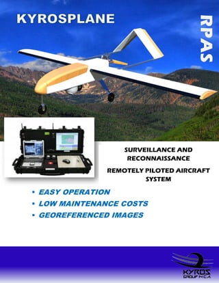
  • 2. The Remotely piloted aircraft system KYROSPLANE is configured for surveillance and reconnaissance missions, completely autonomous flight, in which the capture of video and / or photograph is required. The system operation is carried out by a crew of three (03) people; transportation of equipment is carried out in the same vehicle used as Ground Control Station. APPLICATIONS  BORDER SUVEILLANCE  SUSPECT TRACKING  TRAFFIC MONITORING  DAMAGE ASSESSMENT  WEATHER RESEARCH  DAMAGE SURVEYING  AERIAL PHOTOGRAFY  WILDLIFE MONITORING  PIPE/POWER LINE SURVEILLANCE  AGRICULTURAL APPLICATIONS  COMMUNICATIONS/BROADCAST  AERIAL NEWS COVEREGE  FLOOD MAPING  REAL ESTATE MAPING  MOVIE PRODUCTION TECHNICAL DATA Span 2,6 m Length 1,7 m MTOW 18 Kg Payload 4,6 Kg Cruise Speed: 75 Kts , 140 Km/h Endurance 4 hrs. Range 70 Km Engine 30cc, 3,7 Hp @ 8500rpm Avionic Autonomous Flight System Payload SLR Camera 18 MP, EF (18-55mm) GPS RECEIVER FOR MORE INFORMATION CONTACT US URB. SAN JACINTO, QUINTA AV, EDIF. ARAGUANEY PISO 3, APTO. 3-C, MARACAY , EDO. ARAGUA VENEZUELA 0058-424-3752792 0058-243-2351398 email: kyrosgroup@gmail.com