SlideShare a Scribd company logo
1 of 4
Download to read offline
GaugeKeeper - Optical Water Level Measurement
Key Features:
• Patented system
• Redundant data
• Real-time measurement
• Alarm & alert procedure (definable)
• Visual verification of data
• Direct human interpretation
• Historical data can be downloaded (value + image)
• No more expensive trips to remote
measuring sites
• TCP/IP connectivity
Visible & Verifiable
Camera based water level recording
C13_GaugeKeeper_e 2014-04-07
Gauge Keeper
Components
Many hydrologists have been waiting for a technology to see, measure and
verify their water level data with just one system. And to alert them when
something goes wrong. Using an image sensor for measuring water level is
a new approach. The SEBA GaugeKeeper was developed in order to collect
redundant water level data from remote sites – using image processing and
data transmission.
It has never been easier to verify data from the past – simply select and
have a look at the picture taken at the same moment that the water level was
measured and compare. It‘s that easy.
The surveillance camera is ruggadized, equipped with
special illumination for nighttime measurement and uses
an integrated poweful processor to automatically con-
vert data to measurement values. The frequency is confi-
gurable and the images are saved to a local SD-card for
preservation of evidence. Images and time-lapse movies
may also be downloaded. The water level is measured and
converted inside the processor unit then sent to the log-
ger. All data are stored inside the UnilogCom data logger.
Those data can be downloaded via remote access. There
are several ways to transfer the files to your server or the
SEBA Hydrocenter (e.g. GSM/GPRS, satelite, landline, radio
transmission, DSL, ethernet). Files (values and images) can
alternatively be pushed to an FTP-Server.
The data logger allows connection of additional sensors
(e.g. water level by radar, pressure transducer etc.) for re-
dundant water level data. With the comfortable data ma-
nagement software DEMASdb, the system can be called
several times per day in individually programmable time
slots. Independently, alarm limits can be defined (i.e. wa-
terlevel, battery capacity). SMS alarms can be sent to up to
8 different mobile phone numbers as well as to a facsimile.
(1) Camera (2) Processor Unit + Logger + Data Transmission
Data
Processing
Unilog
COM
Data
Transmission
Image
Capturing
What makes it new and special?
Different from other types of sensors, the Gauge-
Keeper can provide the surrounding information
around the sensor as well as the water level so that
the measured data can be confirmed. It also has
an advantage that it is pretty much unaffected by
weather.
Since conventional methods can measure only the
water level, there is no way to confirm if the provided
data is correct or not. Up until now it has also been
impossible to monitor the surrounding situation of
the river. Our system solves this problem by provi-
ding more accurate measurement of data than the
conventional sensors do. Compared to conventional
approaches, this system does not just rely on wireless
communication, it also saves the data on an SD-card.
Evidence is captured and stored at site additionally
to the transferred data which gives the system even
more redundancy.
No more doubt about why your data drifted: you can
now visually verify every data point as if you were
there – comfortably from your office 24/7. Your field
maintenance will be dramatically reduced and the
reliability and quality of your data will increase con-
siderably.
Prior to using the system for the first time, the GaugeKeeper needs to
be calibrated to the site‘s specific conditions.
That is done via GUI by holding a calibration template facing towards
the camera. An initial value is entered into the system.
The software then calibrates the system and defines an individual
measuring scale. As a final step, the Region of Interest (ROI) is defined .
Edge line detection
Search region
Staff Gauge
Water level detection Region of interest (ROI) (ROI)
Calibration
Visible, verifiable values
• Patented system
• Water level is stored together with the timestamp
• Possibility to connect a second camera ( camera 1 is used for measurement and the 2nd
camera
monitors the scene from a different angle)
• A distance of up to 100 m between camera 1 and ROI is possible
• Low energy consumption which allows battery or solar powered solutions
• In case of very bad sight (e.g. heavy fog) we recommend using an additional pressure sensor for water
level detection to make sure there is no loss of water level registration data.
• Optionally, the system can be extended – provided that local power supply is available
(DSL or ethernet connection).
• A clever alarm management is available.
• Alerted users can visit a specific website to review the hydrographs, images and time-lapse movies
in greater detail to determine whether action is required.
SEBA Hydrometrie GmbH & Co. KG
Gewerbestr. 61a • D-87600 Kaufbeuren
Tel.: +49 (0)8341 / 9648-0
Fax: +49 (0)8341 / 9648-48
E-Mail: info@seba.de
Internet: www.seba.de
Technical Data
Camera Data Logger type GaugeKeeper
Recording: Day & Night
Max. Image Size : 4096 x 1536 (6,2 MEGA) with 2 modules
Image Sensor: 5MP sensor technology: more than
2,5-times detailed than Full-HD
In/Outdoor: Weatherproof (IP66)
Sensor Modules: L12 - L160, horizontal picture angle 180° to
13° (35 mm)
Max. Frame Rate: 30 B/s (MEGA)
Interface: Ethernet 10/100 Mbit
Zoom: Stepless to 8x zoom
Min. Intensity of Light: Colour: 0,25 lux (t=1/60s) • 0,013 lux (t=1/1s)
B/W: 0,05 lux (t=1/60s) • 0,0025 lux (t=1/1s)
Operating
Temperature:
-30 ... +60 °C
Dimensions: 165x170x80 mm (LxWxD)
Power Supply: External 4.5...20 V
Flash Controller: M16C 16 bit with integrated watchdog
Memory: Serial Flash with 4 MB
(approx. 280.000 measured values)
A/D Converter; 32 bit
Inputs: RS485 sensor interfaces (SHWP)
SDI12 sensor interface input (option)
up/down counter input
phase counter, impulse (rain)
2 contact inputs (control, protocol)
2 analogue bi-/unipolar for standard
signals, extendable up to max. 32
analogue inputs (optional with external
module)
Keyboard: with 3 function keys
Display: 3 lines each 16 characters, 3.65 mm
Interfaces: RS232
RS485
micro SD (up to 32 GB)
USB highspeed (up to 2)
ethernet
TCP/IP functionality
Operating
Temperature:
-30...70 °C
Dimensions: 157x126x60 mm (LxWxH)
Modem (integrated) Frequency: 850/900/1800/1900MHz
(EGSM, Quadband)
SIM-card: 1.8V/3V
GaugeKeeper General:
• measuring range: water-level variations of up to 10 m
• power consumption: 60 μA (power down mode)
~ 75 mA (Modem transmitting/peak current)
Special Illumination
Illumination: Infrared, sensor-controlled
Angle: 15°
Energy consumption: 6 mA/h per measurement
Dimensions: 190x125x100 mm (LxWxD)
The right is reserved to change technical specifications without prior notice. The data is valid for the date of printing.

More Related Content

What's hot

Inline freeness transmitter
Inline freeness transmitterInline freeness transmitter
Inline freeness transmitterMiia Moffitt
 
Nanometrics Titan: accelerografi strong motion
Nanometrics Titan: accelerografi strong motion Nanometrics Titan: accelerografi strong motion
Nanometrics Titan: accelerografi strong motion Codevintec Italiana srl
 
Mobile Laser Scanning Workshop
Mobile Laser Scanning WorkshopMobile Laser Scanning Workshop
Mobile Laser Scanning WorkshopNasr Khashoggi
 
Lab 1 data acquisition fundamentals
Lab 1   data acquisition fundamentalsLab 1   data acquisition fundamentals
Lab 1 data acquisition fundamentalsdevneet11
 
data-acquisition-system-ppt
data-acquisition-system-pptdata-acquisition-system-ppt
data-acquisition-system-pptRavi Anand
 
Project ppt 4 channel data acquisition
Project ppt 4 channel data acquisitionProject ppt 4 channel data acquisition
Project ppt 4 channel data acquisitionVineesh Kumar
 
Lectute instrumentation and process control data acquisition
Lectute instrumentation and process control data acquisitionLectute instrumentation and process control data acquisition
Lectute instrumentation and process control data acquisitionrama52
 
2012 Workshop, Introduction to LiDAR Workshop, Bruce Adey and Mark Stucky (Me...
2012 Workshop, Introduction to LiDAR Workshop, Bruce Adey and Mark Stucky (Me...2012 Workshop, Introduction to LiDAR Workshop, Bruce Adey and Mark Stucky (Me...
2012 Workshop, Introduction to LiDAR Workshop, Bruce Adey and Mark Stucky (Me...GIS in the Rockies
 
Jennifer Marsman, Principal Software Development Engineer, Microsoft at MLcon...
Jennifer Marsman, Principal Software Development Engineer, Microsoft at MLcon...Jennifer Marsman, Principal Software Development Engineer, Microsoft at MLcon...
Jennifer Marsman, Principal Software Development Engineer, Microsoft at MLcon...MLconf
 
Raymetrics at Open Coffee Athens #92
Raymetrics at Open Coffee Athens #92Raymetrics at Open Coffee Athens #92
Raymetrics at Open Coffee Athens #92Open Coffee Greece
 
Lidar final ppt
Lidar final pptLidar final ppt
Lidar final pptrsarnagat
 
Autonomous Navigation of UGV Based on AHRS, GPS and LiDAR
Autonomous Navigation of UGV Based on AHRS, GPS and LiDARAutonomous Navigation of UGV Based on AHRS, GPS and LiDAR
Autonomous Navigation of UGV Based on AHRS, GPS and LiDARJohn Liu
 
A Scalable and Distributed Electrical Power Monitoring System Utilizing Cloud...
A Scalable and Distributed Electrical Power Monitoring System Utilizing Cloud...A Scalable and Distributed Electrical Power Monitoring System Utilizing Cloud...
A Scalable and Distributed Electrical Power Monitoring System Utilizing Cloud...Ryousei Takano
 
Data acquisition & system control basic information
Data acquisition & system control basic information Data acquisition & system control basic information
Data acquisition & system control basic information patel andil
 
Data Acquisition System
Data Acquisition SystemData Acquisition System
Data Acquisition Systemrajparkash
 
Multi spectral imaging sensors
Multi spectral imaging sensorsMulti spectral imaging sensors
Multi spectral imaging sensorsLanrewaju ADETUNJI
 
Frank van diggelen keynote, android gnss measurements update
Frank van diggelen keynote, android gnss measurements updateFrank van diggelen keynote, android gnss measurements update
Frank van diggelen keynote, android gnss measurements updateThe European GNSS Agency (GSA)
 
Gisgpsimplementationanduseforstormwatermapping 000 0
Gisgpsimplementationanduseforstormwatermapping 000 0Gisgpsimplementationanduseforstormwatermapping 000 0
Gisgpsimplementationanduseforstormwatermapping 000 0SuKaOt
 

What's hot (20)

Inline freeness transmitter
Inline freeness transmitterInline freeness transmitter
Inline freeness transmitter
 
Nanometrics Titan: accelerografi strong motion
Nanometrics Titan: accelerografi strong motion Nanometrics Titan: accelerografi strong motion
Nanometrics Titan: accelerografi strong motion
 
Mobile Laser Scanning Workshop
Mobile Laser Scanning WorkshopMobile Laser Scanning Workshop
Mobile Laser Scanning Workshop
 
3D remote sensing of mines
3D remote sensing of mines 3D remote sensing of mines
3D remote sensing of mines
 
Lab 1 data acquisition fundamentals
Lab 1   data acquisition fundamentalsLab 1   data acquisition fundamentals
Lab 1 data acquisition fundamentals
 
data-acquisition-system-ppt
data-acquisition-system-pptdata-acquisition-system-ppt
data-acquisition-system-ppt
 
Project ppt 4 channel data acquisition
Project ppt 4 channel data acquisitionProject ppt 4 channel data acquisition
Project ppt 4 channel data acquisition
 
Lectute instrumentation and process control data acquisition
Lectute instrumentation and process control data acquisitionLectute instrumentation and process control data acquisition
Lectute instrumentation and process control data acquisition
 
2012 Workshop, Introduction to LiDAR Workshop, Bruce Adey and Mark Stucky (Me...
2012 Workshop, Introduction to LiDAR Workshop, Bruce Adey and Mark Stucky (Me...2012 Workshop, Introduction to LiDAR Workshop, Bruce Adey and Mark Stucky (Me...
2012 Workshop, Introduction to LiDAR Workshop, Bruce Adey and Mark Stucky (Me...
 
Data Acquisition System
Data Acquisition SystemData Acquisition System
Data Acquisition System
 
Jennifer Marsman, Principal Software Development Engineer, Microsoft at MLcon...
Jennifer Marsman, Principal Software Development Engineer, Microsoft at MLcon...Jennifer Marsman, Principal Software Development Engineer, Microsoft at MLcon...
Jennifer Marsman, Principal Software Development Engineer, Microsoft at MLcon...
 
Raymetrics at Open Coffee Athens #92
Raymetrics at Open Coffee Athens #92Raymetrics at Open Coffee Athens #92
Raymetrics at Open Coffee Athens #92
 
Lidar final ppt
Lidar final pptLidar final ppt
Lidar final ppt
 
Autonomous Navigation of UGV Based on AHRS, GPS and LiDAR
Autonomous Navigation of UGV Based on AHRS, GPS and LiDARAutonomous Navigation of UGV Based on AHRS, GPS and LiDAR
Autonomous Navigation of UGV Based on AHRS, GPS and LiDAR
 
A Scalable and Distributed Electrical Power Monitoring System Utilizing Cloud...
A Scalable and Distributed Electrical Power Monitoring System Utilizing Cloud...A Scalable and Distributed Electrical Power Monitoring System Utilizing Cloud...
A Scalable and Distributed Electrical Power Monitoring System Utilizing Cloud...
 
Data acquisition & system control basic information
Data acquisition & system control basic information Data acquisition & system control basic information
Data acquisition & system control basic information
 
Data Acquisition System
Data Acquisition SystemData Acquisition System
Data Acquisition System
 
Multi spectral imaging sensors
Multi spectral imaging sensorsMulti spectral imaging sensors
Multi spectral imaging sensors
 
Frank van diggelen keynote, android gnss measurements update
Frank van diggelen keynote, android gnss measurements updateFrank van diggelen keynote, android gnss measurements update
Frank van diggelen keynote, android gnss measurements update
 
Gisgpsimplementationanduseforstormwatermapping 000 0
Gisgpsimplementationanduseforstormwatermapping 000 0Gisgpsimplementationanduseforstormwatermapping 000 0
Gisgpsimplementationanduseforstormwatermapping 000 0
 

Viewers also liked

Null Xposed Framework internals and writing modules
Null Xposed Framework internals and writing modulesNull Xposed Framework internals and writing modules
Null Xposed Framework internals and writing modulesAbhinav Chourasia, GMOB
 
Gitxaala Nation et al. v. Canada, 2016 FCA 187
Gitxaala Nation et al. v. Canada, 2016 FCA 187 Gitxaala Nation et al. v. Canada, 2016 FCA 187
Gitxaala Nation et al. v. Canada, 2016 FCA 187 Gordon Scott Campbell
 
BeCommerce X-mas 2015 - sale 2016
BeCommerce  X-mas 2015 - sale 2016BeCommerce  X-mas 2015 - sale 2016
BeCommerce X-mas 2015 - sale 2016Carmen Machiels
 
стронговська ми діти неньки одної
стронговська ми діти неньки одноїстронговська ми діти неньки одної
стронговська ми діти неньки одноїRuslanStrilchuk
 
The woodlands home sales rpt january 2016
The woodlands home sales rpt   january 2016The woodlands home sales rpt   january 2016
The woodlands home sales rpt january 2016jchellew
 
Analisis propuesta general
Analisis propuesta generalAnalisis propuesta general
Analisis propuesta generalJonathan MH
 
Presentation battle briefing mwell's conflicted copy 2016 13-06
Presentation battle briefing mwell's conflicted copy 2016 13-06Presentation battle briefing mwell's conflicted copy 2016 13-06
Presentation battle briefing mwell's conflicted copy 2016 13-06chrisseth
 

Viewers also liked (9)

Null Xposed Framework internals and writing modules
Null Xposed Framework internals and writing modulesNull Xposed Framework internals and writing modules
Null Xposed Framework internals and writing modules
 
Slideshare
SlideshareSlideshare
Slideshare
 
Gitxaala Nation et al. v. Canada, 2016 FCA 187
Gitxaala Nation et al. v. Canada, 2016 FCA 187 Gitxaala Nation et al. v. Canada, 2016 FCA 187
Gitxaala Nation et al. v. Canada, 2016 FCA 187
 
BeCommerce X-mas 2015 - sale 2016
BeCommerce  X-mas 2015 - sale 2016BeCommerce  X-mas 2015 - sale 2016
BeCommerce X-mas 2015 - sale 2016
 
стронговська ми діти неньки одної
стронговська ми діти неньки одноїстронговська ми діти неньки одної
стронговська ми діти неньки одної
 
The woodlands home sales rpt january 2016
The woodlands home sales rpt   january 2016The woodlands home sales rpt   january 2016
The woodlands home sales rpt january 2016
 
Analisis propuesta general
Analisis propuesta generalAnalisis propuesta general
Analisis propuesta general
 
Presentation battle briefing mwell's conflicted copy 2016 13-06
Presentation battle briefing mwell's conflicted copy 2016 13-06Presentation battle briefing mwell's conflicted copy 2016 13-06
Presentation battle briefing mwell's conflicted copy 2016 13-06
 
diploma masterr
diploma  masterrdiploma  masterr
diploma masterr
 

Similar to C13_GaugeKeeper_englisch

PointSense Portable Logger Data Sheet
PointSense Portable Logger Data SheetPointSense Portable Logger Data Sheet
PointSense Portable Logger Data SheetHolly Pearce
 
2900ET.pdf
2900ET.pdf2900ET.pdf
2900ET.pdfRamaSry
 
Guide To Data Acquisition Systems (Daq Systems) - TMCS.docx
Guide To Data Acquisition Systems (Daq Systems) - TMCS.docxGuide To Data Acquisition Systems (Daq Systems) - TMCS.docx
Guide To Data Acquisition Systems (Daq Systems) - TMCS.docxTMCS India
 
( KEVIN SONI )DATA ACQUISITION SYSTEM
( KEVIN SONI )DATA ACQUISITION SYSTEM ( KEVIN SONI )DATA ACQUISITION SYSTEM
( KEVIN SONI )DATA ACQUISITION SYSTEM Kevin Soni
 
weather monitoiring system.pptx
weather monitoiring system.pptxweather monitoiring system.pptx
weather monitoiring system.pptxPranayBathini1
 
Automated Substation Monitoring with Thermal Imaging
Automated Substation Monitoring with Thermal Imaging Automated Substation Monitoring with Thermal Imaging
Automated Substation Monitoring with Thermal Imaging Power System Operation
 
RDSO Training ppt
RDSO Training pptRDSO Training ppt
RDSO Training pptPooja A
 
Computer Vision for Measurement & FR
Computer Vision for Measurement & FRComputer Vision for Measurement & FR
Computer Vision for Measurement & FRRekaNext Capital
 
Advance surveying equipments
Advance surveying equipmentsAdvance surveying equipments
Advance surveying equipmentsSuryaom Tiwari
 
SysEng Computer Vison Systems
SysEng Computer Vison SystemsSysEng Computer Vison Systems
SysEng Computer Vison SystemsRekaNext Capital
 
Intelligent sensor networks 15 11-2016
Intelligent sensor networks 15 11-2016Intelligent sensor networks 15 11-2016
Intelligent sensor networks 15 11-2016Ron van Dooren
 
IsodaqGPRSbrochureapril15v6a4lro
IsodaqGPRSbrochureapril15v6a4lroIsodaqGPRSbrochureapril15v6a4lro
IsodaqGPRSbrochureapril15v6a4lroAnjie Stevens
 
Digital signal processing
Digital signal processingDigital signal processing
Digital signal processingsivakumars90
 
IRJET- Land Mine Data Collection System using Long Range WiFi and P2P Com...
IRJET-  	  Land Mine Data Collection System using Long Range WiFi and P2P Com...IRJET-  	  Land Mine Data Collection System using Long Range WiFi and P2P Com...
IRJET- Land Mine Data Collection System using Long Range WiFi and P2P Com...IRJET Journal
 

Similar to C13_GaugeKeeper_englisch (20)

PointSense Portable Logger Data Sheet
PointSense Portable Logger Data SheetPointSense Portable Logger Data Sheet
PointSense Portable Logger Data Sheet
 
2900ET.pdf
2900ET.pdf2900ET.pdf
2900ET.pdf
 
Data loggers
Data loggers Data loggers
Data loggers
 
Data logger
Data loggerData logger
Data logger
 
Guide To Data Acquisition Systems (Daq Systems) - TMCS.docx
Guide To Data Acquisition Systems (Daq Systems) - TMCS.docxGuide To Data Acquisition Systems (Daq Systems) - TMCS.docx
Guide To Data Acquisition Systems (Daq Systems) - TMCS.docx
 
( KEVIN SONI )DATA ACQUISITION SYSTEM
( KEVIN SONI )DATA ACQUISITION SYSTEM ( KEVIN SONI )DATA ACQUISITION SYSTEM
( KEVIN SONI )DATA ACQUISITION SYSTEM
 
weather monitoiring system.pptx
weather monitoiring system.pptxweather monitoiring system.pptx
weather monitoiring system.pptx
 
datalogger
dataloggerdatalogger
datalogger
 
Automated Substation Monitoring with Thermal Imaging
Automated Substation Monitoring with Thermal Imaging Automated Substation Monitoring with Thermal Imaging
Automated Substation Monitoring with Thermal Imaging
 
RDSO Training ppt
RDSO Training pptRDSO Training ppt
RDSO Training ppt
 
Computer Vision for Measurement & FR
Computer Vision for Measurement & FRComputer Vision for Measurement & FR
Computer Vision for Measurement & FR
 
Advance surveying equipments
Advance surveying equipmentsAdvance surveying equipments
Advance surveying equipments
 
SysEng Computer Vison Systems
SysEng Computer Vison SystemsSysEng Computer Vison Systems
SysEng Computer Vison Systems
 
Intelligent sensor networks 15 11-2016
Intelligent sensor networks 15 11-2016Intelligent sensor networks 15 11-2016
Intelligent sensor networks 15 11-2016
 
Homeland Security Solutions
Homeland Security SolutionsHomeland Security Solutions
Homeland Security Solutions
 
IsodaqGPRSbrochureapril15v6a4lro
IsodaqGPRSbrochureapril15v6a4lroIsodaqGPRSbrochureapril15v6a4lro
IsodaqGPRSbrochureapril15v6a4lro
 
Digital signal processing
Digital signal processingDigital signal processing
Digital signal processing
 
Ve ex cx380s d3 docsis30 (1)
Ve ex cx380s d3 docsis30 (1)Ve ex cx380s d3 docsis30 (1)
Ve ex cx380s d3 docsis30 (1)
 
Serinus 50-so2-gas-analyser
Serinus 50-so2-gas-analyserSerinus 50-so2-gas-analyser
Serinus 50-so2-gas-analyser
 
IRJET- Land Mine Data Collection System using Long Range WiFi and P2P Com...
IRJET-  	  Land Mine Data Collection System using Long Range WiFi and P2P Com...IRJET-  	  Land Mine Data Collection System using Long Range WiFi and P2P Com...
IRJET- Land Mine Data Collection System using Long Range WiFi and P2P Com...
 

C13_GaugeKeeper_englisch

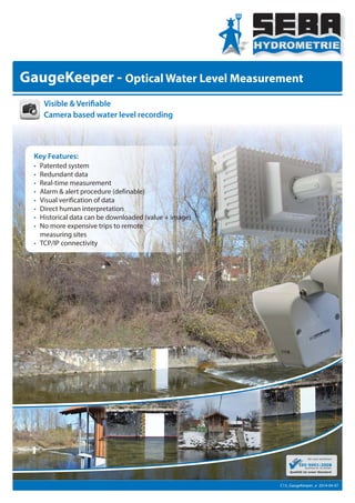
  • 1. GaugeKeeper - Optical Water Level Measurement Key Features: • Patented system • Redundant data • Real-time measurement • Alarm & alert procedure (definable) • Visual verification of data • Direct human interpretation • Historical data can be downloaded (value + image) • No more expensive trips to remote measuring sites • TCP/IP connectivity Visible & Verifiable Camera based water level recording C13_GaugeKeeper_e 2014-04-07
  • 2. Gauge Keeper Components Many hydrologists have been waiting for a technology to see, measure and verify their water level data with just one system. And to alert them when something goes wrong. Using an image sensor for measuring water level is a new approach. The SEBA GaugeKeeper was developed in order to collect redundant water level data from remote sites – using image processing and data transmission. It has never been easier to verify data from the past – simply select and have a look at the picture taken at the same moment that the water level was measured and compare. It‘s that easy. The surveillance camera is ruggadized, equipped with special illumination for nighttime measurement and uses an integrated poweful processor to automatically con- vert data to measurement values. The frequency is confi- gurable and the images are saved to a local SD-card for preservation of evidence. Images and time-lapse movies may also be downloaded. The water level is measured and converted inside the processor unit then sent to the log- ger. All data are stored inside the UnilogCom data logger. Those data can be downloaded via remote access. There are several ways to transfer the files to your server or the SEBA Hydrocenter (e.g. GSM/GPRS, satelite, landline, radio transmission, DSL, ethernet). Files (values and images) can alternatively be pushed to an FTP-Server. The data logger allows connection of additional sensors (e.g. water level by radar, pressure transducer etc.) for re- dundant water level data. With the comfortable data ma- nagement software DEMASdb, the system can be called several times per day in individually programmable time slots. Independently, alarm limits can be defined (i.e. wa- terlevel, battery capacity). SMS alarms can be sent to up to 8 different mobile phone numbers as well as to a facsimile. (1) Camera (2) Processor Unit + Logger + Data Transmission Data Processing Unilog COM Data Transmission Image Capturing What makes it new and special? Different from other types of sensors, the Gauge- Keeper can provide the surrounding information around the sensor as well as the water level so that the measured data can be confirmed. It also has an advantage that it is pretty much unaffected by weather. Since conventional methods can measure only the water level, there is no way to confirm if the provided data is correct or not. Up until now it has also been impossible to monitor the surrounding situation of the river. Our system solves this problem by provi- ding more accurate measurement of data than the conventional sensors do. Compared to conventional approaches, this system does not just rely on wireless communication, it also saves the data on an SD-card. Evidence is captured and stored at site additionally to the transferred data which gives the system even more redundancy. No more doubt about why your data drifted: you can now visually verify every data point as if you were there – comfortably from your office 24/7. Your field maintenance will be dramatically reduced and the reliability and quality of your data will increase con- siderably.
  • 3. Prior to using the system for the first time, the GaugeKeeper needs to be calibrated to the site‘s specific conditions. That is done via GUI by holding a calibration template facing towards the camera. An initial value is entered into the system. The software then calibrates the system and defines an individual measuring scale. As a final step, the Region of Interest (ROI) is defined . Edge line detection Search region Staff Gauge Water level detection Region of interest (ROI) (ROI) Calibration Visible, verifiable values • Patented system • Water level is stored together with the timestamp • Possibility to connect a second camera ( camera 1 is used for measurement and the 2nd camera monitors the scene from a different angle) • A distance of up to 100 m between camera 1 and ROI is possible • Low energy consumption which allows battery or solar powered solutions • In case of very bad sight (e.g. heavy fog) we recommend using an additional pressure sensor for water level detection to make sure there is no loss of water level registration data. • Optionally, the system can be extended – provided that local power supply is available (DSL or ethernet connection). • A clever alarm management is available. • Alerted users can visit a specific website to review the hydrographs, images and time-lapse movies in greater detail to determine whether action is required.
  • 4. SEBA Hydrometrie GmbH & Co. KG Gewerbestr. 61a • D-87600 Kaufbeuren Tel.: +49 (0)8341 / 9648-0 Fax: +49 (0)8341 / 9648-48 E-Mail: info@seba.de Internet: www.seba.de Technical Data Camera Data Logger type GaugeKeeper Recording: Day & Night Max. Image Size : 4096 x 1536 (6,2 MEGA) with 2 modules Image Sensor: 5MP sensor technology: more than 2,5-times detailed than Full-HD In/Outdoor: Weatherproof (IP66) Sensor Modules: L12 - L160, horizontal picture angle 180° to 13° (35 mm) Max. Frame Rate: 30 B/s (MEGA) Interface: Ethernet 10/100 Mbit Zoom: Stepless to 8x zoom Min. Intensity of Light: Colour: 0,25 lux (t=1/60s) • 0,013 lux (t=1/1s) B/W: 0,05 lux (t=1/60s) • 0,0025 lux (t=1/1s) Operating Temperature: -30 ... +60 °C Dimensions: 165x170x80 mm (LxWxD) Power Supply: External 4.5...20 V Flash Controller: M16C 16 bit with integrated watchdog Memory: Serial Flash with 4 MB (approx. 280.000 measured values) A/D Converter; 32 bit Inputs: RS485 sensor interfaces (SHWP) SDI12 sensor interface input (option) up/down counter input phase counter, impulse (rain) 2 contact inputs (control, protocol) 2 analogue bi-/unipolar for standard signals, extendable up to max. 32 analogue inputs (optional with external module) Keyboard: with 3 function keys Display: 3 lines each 16 characters, 3.65 mm Interfaces: RS232 RS485 micro SD (up to 32 GB) USB highspeed (up to 2) ethernet TCP/IP functionality Operating Temperature: -30...70 °C Dimensions: 157x126x60 mm (LxWxH) Modem (integrated) Frequency: 850/900/1800/1900MHz (EGSM, Quadband) SIM-card: 1.8V/3V GaugeKeeper General: • measuring range: water-level variations of up to 10 m • power consumption: 60 μA (power down mode) ~ 75 mA (Modem transmitting/peak current) Special Illumination Illumination: Infrared, sensor-controlled Angle: 15° Energy consumption: 6 mA/h per measurement Dimensions: 190x125x100 mm (LxWxD) The right is reserved to change technical specifications without prior notice. The data is valid for the date of printing.