
Recommended
Recommended
More Related Content
Featured
Featured (20)
Pigliacelli, Darren Assignment 3
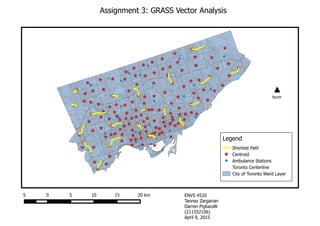
- 1. Assignment 3: GRASS Vector Analysis 5 0 5 10 15 20 km Shortest Path Centroid Ambulance Stations Toronto Centerline City of Toronto Ward Layer Legend North ENVS 4520 Tannaz Zargarian Darren Pigliacelli (211552106) April 9, 2015
- 2. ENVS 4520 Tannaz Zargarian Darren Pigliacelli (211552106) April 9, 2015 Assignment 3: GRASS Vector Analysis
- 6. Shortest Path Attribute Table:
- 7. Questions:
- 8. Are response times slower in some neighborhoods than others? • Yes, response times vary and in some neighborhoods are slower than others. In the downtown areas where urban development is dense, the response times are shorter because there are more ambulance stations. In the suburban areas of Toronto the response times are longer because there is less ambulance stations compared to the downtown areas because there is a smaller, less dense population. Do you see any pattern in how the response times vary? • There is no distinct pattern in the data, but relating to answer 1, the response times are longer in the less dense, suburban areas of Toronto and the response times are shorter in the dense, higher populated areas near downtown. What else might you use this kind of network analysis for? • This network analysis might be used for salt trucks in the winter, garbage trucks to find shortest routes, businesses to find shortest distances to their target market neighborhoods, for emergency response times for police, fire and ambulance vehicles to find the shortest routes to a location and for City of Toronto service trucks to find their shortest routes from their station to service locations.