SlideShare a Scribd company logo
1 of 19
Download to read offline
Figure 1.1: Manam eruption 12 January 2013, Fr Bogdan Skupien.
Darwin Volcanic Ash Advisory Centre
18 June 2013
MANAM: 12/01/2013
Caveat:{This report is preliminary and intended to provide a
practical evaluation of the event. Please do not reproduce comments
made here without seeking permission from the VAAC Darwin.}
1 Background
Figure 1.1 Geographic location of Manam volcano
Manam (4°4'48" S and 145°2'14" E, summit elevation 1807m) is a basaltic-andesitic
stratovolcano located on the 10-km-wide island of Manam off the northern coast of
Papua New Guinea. Four radial valleys extend from the summit and are each located
about 90 degrees apart. Manam’s first recorded eruption was in 1616. It has erupted
at least 44 times since 1616 until the 12 January 2013 eruption. Most eruptions have
occurred in South Crater with eight in both the South and Main Crater. Manam is one
of the most active volcanoes in Papua New Guinea. Since 2004, VAAC Darwin has
issued 733 advisories for Manam. Its largest recorded eruption was on 23-24
November 2004 as a VEI-4 on the Volcanic Explosivity Index (VEI).
Figure 1.2 VAAC Darwin Volcanic Ash Advisories since 2004
2 Discussion
2.1 Eruption Summary
Very mild activity was observed from Manam in
the Southern crater between 8-11 January. Thin
dark grey ash clouds were observed occasionally
until early on the 12th
. Seismicity to start the
period was low on 8 January with a Real-time
Seismic Amplitude Measurements (RSAM) of 80,
but increased to the moderate levels of 200 by the
11th
. The RSAM reached 550 on 12 January
between 0000-0100Z and coincided with the
commencement of a small sub-plinian eruption
according to Rabaul Volcano Observatory (RVO).
A peak RSAM of 620 was reported at 1300 UTC
on 12 January. The Main Crater remained quiet
with only thin to thick white vapour emissions.
The eruption was not visible on MTSAT-2 until 0232 UTC due to meteorological
cloud from the monsoonal flow. Moderate to strong winds from the northwest to the
northeast blew the ash plumes to the southwest, south and southeast. Satellite
analysis indicates the initial ash cloud to the southeast rose approximately 6km ASL
(20,000ft) by 0532 UTC. A larger eruption near 0400 UTC spread west from Manam
and rose to approximately 14km ASL (45,000ft) by 0532 UTC. Continuous forceful
projections of moderate thick dark grey ash clouds occurred until 0600 UTC. Ground
reports indicate that the ash cloud height was observed to 1500m above the summit or
3307m ASL (11,000ft). After 0600 UTC, ground reports indicated ash plume heights
were to 500m above the summit or 2307m ASL (7,500ft). Incandescent lava
fragments were visible
during the eruption.
From 13-14 January,
there were occasional to
regular emissions of
thick to thin ash clouds
that were grey to dark
in colour.
Polygons began to be
dropped starting with
the 13 January Volcanic
Ash Advisory at 0247
UTC. Meteorological
cloud made if difficult
to verify ash, but clearing was evident to
the west for SFC/FL400 and to the south
from SFC/FL200. The ash dispersion
model seemed to overdo the ash boundary
and the VA forecaster scaled back the
Fig. 2.1 Manam erupting 12
Jan 2013, Fr. Bogdan
Skupien
Figure 2.2 Manam.
12 Jan 2013, approximately 2230
UTC, 20 hours after eruption began.
Fr. Bogdan Skupien
polygon with the evidence of clearing. The final advisory was issued on 13 January at
1928 UTC.
2.2 VAAC Darwin Advisories
The eruption was first identified to VAAC Darwin at 0545 UTC in a call from an
airline. An Urgent Initial Advisory was issued at 0555 UTC after it was determined
Manam was erupting. The forecaster saw what appeared to be storm activity near the
volcano that did not fit the pattern of convection. A dispersion forecast model was
run to 55,000ft (FL550) to determine the track of the ash after the Urgent Initial. A
second pilot report was received at 0600 UTC from another airline identifying Manam
and ash to FL500.
The MTSAT-2 VIS image
from 0432 UTC was used to
determine the ash cloud
height as be 40,000ft (FL400)
using a brightness
temperature of 225K (-48C)
and the Manus 12/0000 UTC
sounding. Movement was
based on the model run and
Manus upper winds.
Figure 2.3 12 January 2013 MTSAT-2 IR 0432 UTC, The original plume southeast
of Manam remains visible as it reaches Papua New Guinea’s coastline. Winds spread
ash to the south.
Before the follow up advisory was sent a new MTSAT image became available. On
the MTSAT-2 IR
0532 UTC, using
the brightness
temperature of
209K (-64C) the
ash cloud height
was 45,000ft ASL.
The plume height
was changed to
FL450 and the
advisory sent at
0625 UTC.
Figure 2.4 12 January 2013 MTSAT-2 IR 0532 UTC, depicting ash clouds extending
to the west and east of Manam.
Figure 2.5 Manus 0000 UTC 12 Jan 2013 sounding.
In the follow up advisory at 0625 UTC/12 January, detailed information was given
providing the information sources and the movement of the ash in two separate
polygons to the west at 45,000ft (FL450) and to the southeast at 20,000ft (FL200).
Polygons were advanced forward in the 1230 UTC advisory, to match the ash
dispersion forecast.
Meteorological cloud cover near Manam made it difficult to identify volcanic ash
movement overnight. In the 1815 UTC advisory, the 2 layer polygons were
maintained from the previous advisory with the 15 KT NW monsoon steering the
SFC/FL200 plume and the SE steering wind for the ash to FL450.
The 2303 UTC advisory adjusted the polygons using the VDIFF 2100 UTC imagery.
There was a suspicious cloud to the north in addition to considerable meteorological
cloud in the area.
Fig. 2.6 MTSAT-2 IR 2332 UTC, 12 January 2013. Meteorological cloud around
Manam made it difficult to determine the extent of the ash.
Figure 2.7: Volcanic Ash Advisory Graphic issued by Darwin VAAC at 2303 UTC
on 12 January.
New satellite images confirmed that the area of volcanic ash was diminishing. The
polygons for SFC/FL 400 and SFC/FL200 were both downgraded. There was
clearing evident on the FY-2 13/0201 UTC satellite to the west and south of Manam.
Volcanic ash was visible in some areas, but was difficult to determine the exact extent
of the ash except in areas free of meteorological cloud.
Figure 2.8: Volcanic Ash Advisory Graphic issued by Darwin VAAC at 0247 UTC
on 13 January.
Figure 2.9 Volcanic Ash Advisory Graphic issued by Darwin VAAC at 0801Z on 13
January.
The VA Forecaster cancelled the FL400 polygon due to lack of reports and
identifiable volcanic ash on satellite images. No new reports of volcanic ash came in
and polygons continued to be downgraded. The final VA Advisory 2013/9 was issued
at 1928 UTC on 13 January.
2.3 Pilot Reports
VAAC Darwin received a phone call from an airline flying through the region of New
Guinea on 12 January at 0545Z. They observed a volcanic ash cloud above FL500 on
the north coast of New Guinea.
At 0600 UTC, the VAAC received an AIREP from a different airline. The AIREP
reported the ash height to be FL500 and identified the volcano as Manam with ash
drifting in a westerly direction.
AIREP
_QBA0182 120600
DD YPDMYMYX YBBBZEZX WIIIYOYX WIIIYNYX RPHIZRZX NZKLYMYX
120600 YSSYQFAO
_ARS AIREP SPECIAL VOLCANIC ASH ADVICE FROM QANTAS OPS DESK:
1) AIRCRAFT IDENT:QFA5720
2) A/C TIME/POSN :130534Z AYKK
3) A/C ALTITUDE :FL300
4) VOLC NBR :501-02
5) VOLC ACTIVITY :MANAM S04 05.99 E145 03.66
6) DRIFT OF ASH :WESTERLY
7) AIR TEMP :UNKNOWN
8) SPOT WIND :UNKNOWN
9) PLUME HGT :FL500
10)SUPP INFO :AWTG UPDATE FROM DRW VAAC. 2 AIRCRAFT HAVE
REPORTED SAME
PLEASE CHECK WITH YOUR OWN SOURCES FOR FURTHER DATA:
2.4 Ground Reports
VAAC Darwin was able to visually review Manam’s eruption. Fr. Bogdan Skupien, a
Catholic priest travelled from Bogia at 0400 UTC arriving at Bieng-Manam at 0545
UTC. He noted the eruption at 0600 UTC while taking the boat out of the water. At
the time he did not notice an earthquake or any sound of a big explosion. He saw the
black clouds of
ashes and the fire
coming out of the
volcano
simultaneously.
The next morning
between 2200 UTC
and 2300UTC 12
January while
coming back from
Boisa Island after
the morning service
Fr. Bogdan took
pictures of Manam’s
activity.
Fig. 2.10 Close up eruption of Manam with ash and lava. 12 January, photo taken
after near 0600 UTC. Fr. Bogdan Skupien.
2.5 Volcanological Reports
The status of Manam was upgraded to Alert Level II by Rabaul Volcano Observatory
(RVO) on 16 June 2012 due to raised levels of activity and seismicity. This included
four pyroclastic flows on 16 June 2012. Over the last seven months, the (Department
of Mineral Policy & Geohazards Management (DMPGM) has given reports on the
activity in their Volcano Information Bulletins on 16 June, 1 July, 1 August, 3
October, 17 October, 25 November, 8 December and 16 December. Activity before
the 12 January eruption was high as recorded by the Real-time Seismic Amplitude
Measurements (RSAM). A long-term inflationary trend towards the east and
continuous volcanic tremors also marked the activity at Manam.
“The volcanic tremors and other reported observations suggest
the eruptive activity at Southern Crater of Manam is expected
to continue. Moreover, discrete phases of stronger
strombolian/sub-plinian activity and discrete pyroclastic
flows may occur as well.” Prognosis 8/12/12 report DMPGM
An email was sent to Rabaul Volcano Observatory (RVO) at 0731 UTC on 12
January inquiring of a high level eruption. Confirmation was received of an eruption
at 0812 UTC. Initial reports from RVO indicated that the eruption began around 0300
UTC and increased in intensity between 0500-0600Z. Visible MTSAT-2 images at
0232 UTC confirm the eruption before 0300 UTC. Light ashfall was reported on the
mainland generally west of Manam around 0700 UTC. The height of the eruption
was reported to be 1500m above the summit (FL110) by the observer.
Figure 2.11 12 January 2013 MTSAT-
2 VIS 0232 UTC, The initial eruption
of Manam is seen to the southeast.
In the Volcano Information Bulletin
issued 15 January 2013, RVO reported that a small sub-plinian eruption began at
0000Z on the South Crater 12 January. It peaked between 0200-0300Z. Moderate
dark grey ash clouds rose to FL110 (11,000 ft.) lasting approximately 6 hours. Strong
NW-NE winds steered the airborne ash plumes to the south. After 0600Z, activity
subsided with ash plumes to FL075 (7,500ft). From 13-14 January, there was
occasional to regular ash cloud emissions varying from thin and grey to thick and dark.
2.6 Ash Height Calculation
During the eruption of Manam, there was a
significant difference in heights reported by
pilots, satellite and the ground based observer.
The eruption which began at 10 am local time
peaked around Noon-1 pm before subsiding after
4pm. Darkness was not a factor in the
calculation of ash plume height. In the photo to
the left, supplied by Fr. Bogdan from the day of
the eruption, the max ash plume height cannot be
determined. It pushes through the volcanic ash
and meteorological cloud in the vicinity. With
the monsoonal flow in the region, this could have
lifted the volcanic ash to the higher levels as seen
on satellite and through pilot reports. Another
explanation for the disparity of the height could
be the proximity to the eruption. At close range
to the volcano crater, it is difficult for a ground
Fig. 2.12 Ash plume from Manam pushing
through meteorological clouds and volcanic ash
clouds. 12 Jan 2013, Fr. Bogdan Skupien
based observer to fully view the eruption column and estimate the maximum height.
The ground based observer placed the eruption height at 1400-1500m above the
summit (10,500-10,900ft ASL). The two aviation reports indicated the height of the
ash to be at a much higher level 50,000ft and 50,000ft plus. VAAC Darwin initially
analysed satellite data to determine that the height was 40,000ft, but then revised the
height to 45,000ft before the advisory was issued when a new satellite image became
available.
Pilot report
0545 UTC
Pilot Report
0600 UTC
Ground
Observer
0300 UTC
Satellite
0532 UTC
Height of
volcanic ash
plume
FL500 FL500+ FL110 FL450
Figure 2.13 Cloud cover at Manam Island the afternoon of 12 January 2013. Photo
by Fr. Bogdan Skupien between 0400-0545 UTC.
Figure 2.14 12 January 2013 MTSAT-2 IR 0532 UTC, depicting ash clouds
extending to the west/southwest and southeast of Manam.
During the eruption, ash fall was reported in
three locations across the island to the west,
south and southeast of the volcano. The
volcanic ash was picked up on satellite
moving to the southeast and to the west/northwest. The VA forecaster used the
Manus sounding model from 12/0000 UTC along with MTSAT-2 IR to determine the
height of the ash from Manam. The ash to 20,000ft (FL200) was being steered by a
NW 15kt monsoon flow while the ash to 45,000ft (FL450) was being steered by an
east, southeast wind.
2.7 Aviation Warnings
There was only one aviation warning issued during the Manam eruption. NOTAM
A0041/13 NOTAMN valid from 12 January 0530 UTC to 31 January 0630 UTC was
for ash drifting to the NE at FL200. There was not a NOTAM for ash to FL450.
NBA2277
GG YBZZJSTX YBBBVOZX YBBBNOTM
121023 YBBBZEZX
(A0041/13 NOTAMN
Q)AYPM/QWWXX/IV/BO/W/000/999/
A)AYPM
Figure 2.15 12 January 2013 MTSAT-2
VIS 0532 UTC
B)1301120530 C)1301310630 EST
E)CAUTION VOLCANIC ACT ON MANAM ISLAND
(COORD S04 04 40.70 E145 02 15.74) ASH CLD
UP TO 20,000FT DRIFT TO NE DIRECTION)
There were no SIGMETs issued by PNG. VAAC Darwin received calls from the
Brisbane ATC and the NOC Met about the lack of SIGMETs. The Volcanic Ash
Meteorologist attempted to contact RVO via phone and email without any success.
PNG AirServices was contacted with a fax of the advisory and they responded with a
NOTAM to FL200.
The NOTAM issued was confirmed at 2200 UTC on 12 January by a pilot on a flight
between Madang and Wewak on a climb to F270. Volcanic Ashes were spewing from
Manam Island Volcano with the top of the ashes reaching up to F200 and a
northeasterly drift. The ashes were not as thick as the previous day.
On the 15 January, VAAC Darwin was notified that 0041/13 NOTAMN was still
valid. A fax with a copy of our last advisory for Manam (1928 UTC, 13 January) for
Manam was sent to the Pt. Moresby MWO and the NOTAM was cancelled.
2.8 Sulphur-Dioxide Data
A SACS (Support to Aviation Control Service) multi-sensor warning was received for
exceptional SO2 concentration at 1329 UTC 12 January. The region of SO2 was
detected by a pass of the satellite IASI EUMETSAT at 1244 UTC. Ash and SO2 can
be ejected to similar heights during a high level eruption. As they move away from
the volcano they follow a similar distribution pattern with the upper level winds.
Meteorological processes cause them to diverge and the amount of ash within a SO2
region diminishes until it becomes negligible. The information received from the
SACS multi-sensor warning showed that ash and SO2 were collocated.
The SO2/Ash signal that triggered a SACS SO2 alert was slightly west of the current
polygon valid at 12/1215 UTC. The SO2/Ash area was covered in the next timestamp
at 12/1815 UTC. VAAC Darwin received the alert at 1359 UTC. Meteorological
clouds remained in the area due to the monsoonal flow.
Figure 2.16 IASI SO2 Image over Papua New Guinea, 1244 UTC 12 January.
Figure 2.17 IASI Ash Index Image over Papua New Guinea, 1244 UTC 12 January.
Figure 2.18 OMI SO2 ASI Image over Papua New Guinea, 0446 UTC 12 January.
3 Recommendations
Recommendation Manam: 120113/1 – That procedures for contacting Pt. Moresby
MWO when there is an advisory in their area be included in the VAAC Darwin
Volcanic Ash Directive.
Communication challenges between Pt. Moresby MWO and VAAC Darwin have
resulted in SIGMETs not being issued or cancelled within a timely manner. Since
communication channels are not always reliable, one approach is to fax the advisory
to them after it is issued. The receipt of information is confirmed by fax and they
have access to the information that they need to issue appropriate SIGMETs.
Recommendation Manam: 120113/2 – Expand the role of SPOCS within the RFC to
serve as quality control in the VAAC. During high level eruptions, they are to ensure
that forecasters send out Urgent Initial and Follow Up Advisories within a timely
manner.
Aviation clients have stressed the importance of getting the message out first than
fine-tuning it. VA forecasters when first alerted to a high level eruption should issue
an Urgent Initial Advisory as soon as possible and then follow up with a detailed
advisory within 20 minutes. During the initial stages of an eruption, the flight level
may change as more information is available from sources. It can then be fine tuned
in the next advisory with the additional sources input. Valuable time should not be
spent changing an advisory before it is issued from a FL400 to a FL450. Airlines will
not be flying through this area and it is more important to meet the 20 minute deadline
detailing the ash location and forecast.
Recommendation Manam: 120113/3 – Update the Volcanic Ash Directive that for
high level eruptions, the VA forecaster needs to start work on the update for an
advisory no less than 1 hour before the reissue time.
When an advisory is not updated for a high level eruption within the 6 hour timeframe,
VAAC Darwin is not providing the level of service it should for its clients. Clients
begin to call and that slows down the process even further. There are many obstacles
that a VA forecaster can run into when preparing an advisory update. Some sources
of information may not be available or satellite information can be inconclusive and
additional sources of data will need to be investigated. By starting 1 hour before the
VAA is due, this will allow the VA Forecaster adequate time to investigate all
available date to complete the advisory within the timeframe.
Recommendation Manam: 120113/4 – Provide follow up training with forecasters
to address formatting issues with advisories.
In review of the Manam 12 January 2013 eruption, it was discovered that some VA
advisories were not being correctly formatted. Follow up training to be conducted to
address formatting errors and ensure that clear and informative products are issued by
the VAAC.
A. Urgent Initial Advisory
VA ADVISORY
DTG: 20130112/0555Z
VAAC: Darwin
VOLCANO: Manam 0501-02=
PSN: S0405 E14502
AREA: New Guinea-NE of
SUMMIT ELEV: 1807M
ADVISORY NR: 2013/1
INFO SOURCE:
AVIATION COLOUR CODE: NIL
ERUPTION DETAILS:
OBS VA DTG:
OBS VA CLD: VA NOT IDENTIFIABLE FM SATELLITE DATA
FCST VA CLD +6HR: NO VA EXP
FCST VA CLD +12HR: NO VA EXP
FCST VA CLD +18HR: NO VA EXP
RMK: A MORE DETAILED ADVISORY WILL FOLLOW AS SOON AS POSSIBLE.
NXT ADVISORY: NO LATER THAN 20130112/1145Z
B. Volcanic Ash Advisory (VAA)
VA ADVISORY
DTG: 20130112/1230Z
VAAC: Darwin
VOLCANO: Manam 0501-02=
PSN: S0405 E14502
AREA: New Guinea-NE of
SUMMIT ELEV: 1807M
ADVISORY NR: 2013/3
INFO SOURCE: PILOT REPORT, MTSAT2, NOAA AVIATION COLOUR CODE: RED
ERUPTION DETAILS: ERUPTION LAST OBS TO FL450 AT 12/0530Z
OBS VA DTG: 12/1215Z
OBS VA CLD:
SFC/FL200 S0345 E14450 - S0405 E14605 - S0430 E14515 - S0410 E14420 -
S0345 E14450 MOV W 15KT FL200/450 S0435 E14445 - S0355 E14535 - S0255
E14130 -
S0405 E14115 - S0435 E14445 MOV W 15KT
FCST VA CLD +6HR: 12/1815Z
SFC/FL200 S0355 E14440 - S0435 E14400 - S0535 E14550 - S0440 E14635 -
S0355 E14440 FL200/450 S0435 E14445 - S0355 E14535 - S0230 E13835 -
S0340 E13810 - S0435 E14445 FCST VA CLD +12HR: 13/0015Z SFC/FL200
S0345 E14445 - S0500 E14250 - S0615 E14725 -
S0515 E14745 - S0345 E14445
FL200/450 S0435 E14440 - S0355 E14530 - S0155 E13615 - S0310 E13545 -
S0435 E14440 FCST VA CLD +18HR: 13/0615Z SFC/FL200 S0345 E14440 -
S0510 E14215 - S0645 E14825 - S0530 E14905 - S0345 E14440 FL200/450
S0435 E14445 - S0355 E14535 - S0155 E13615 - S0310 E13550 - S0435
E14445
RMK: HEIGHT DERIVED FROM 12/0530Z MTSAT2 IR IMAGE AND MANUS 12/0000Z
SOUNDING, MOVEMENT BASED ON MODEL RUN AND MANUS UPPER WINDS.
NXT ADVISORY: NO LATER THAN 20130112/1815Z
C. VAA Downgrading Polygons
VA ADVISORY
DTG: 20130113/0247Z
VAAC: Darwin
VOLCANO: Manam 0501-02=
PSN: S0405 E14502
AREA: New Guinea-NE of
SUMMIT ELEV: 1807M
ADVISORY NR: 2013/6
INFO SOURCE: MTSAT2, FY
AVIATION COLOUR CODE: RED
ERUPTION DETAILS: VA LAST OBS TO FL400 AT 12/1700Z
OBS VA DTG: 13/0245Z
OBS VA CLD:
SFC/FL200 S0355 E14500 - S0420 E14800 - S0600 E14710 -
S0425 E14435 - S0355 E14500 MOV SE 20KT
SFC/FL400 S0345 E14525 - S0225 E14250 - S0400 E14210 -
S0425 E14445 - S0345 E14525 MOV NW 15KT
FCST VA CLD +6HR: 13/0845Z
SFC/FL200 S0355 E14505 - S0435 E14935 - S0615 E14805 -
S0435 E14420 - S0355 E14505
SFC/FL400 S0350 E14520 - S0145 E14155 - S0355 E14105 -
S0435 E14435 - S0350 E14520
FCST VA CLD +12HR: 13/1445Z
SFC/FL200 S0355 E14455 - S0410 E15125 - S0655 E14840 -
S0445 E14410 - S0355 E14455
SFC/FL400 S0330 E14525 - S0100 E14120 - S0400 E14015 -
S0435 E14425 - S0330 E14525
FCST VA CLD +18HR: 13/2045Z
SFC/FL200
SFC/FL400 NO VA EXP
RMK: HEIGHT FROM 12/1700Z NOAA AND MANUS 12/1100Z SOUNDING, MOVEMENT
BASED ON MODEL AND MANUS SOND. DOWNGRADED POLYGON FL400 AND FL200 DUE
TO SAT IMAGE FY 13/0201Z INDICATING CLEARING W AND S. VA MAY STILL
BE PRESENT IN AREAS WITH METEOROLOGICAL CLOUD.
NXT ADVISORY: NO LATER THAN 20130113/0845Z
D. SACS SO2 Alert Email
-----Original Message-----
From: SACS [mailto:sacs@aeronomie.be]
Sent: Saturday, 12 January 2013 11:29 PM
To: sacs@aeronomie.be
Subject: SACS warning -- IASI -- 2013/01/12 13:58 -- region 311
SACS multi-sensor warning of exceptional SO2 concentration
==========================================================
Process date : 2013/01/12
Process time : 13:58 UTC
Instrument : IASI
Warning region: 311
---------------------
http://sacs.aeronomie.be/IASIalert/2013/01/alertsIASI_20130112_12h44_
311.php?alert=20130112_135811_311
Date : 2013/01/12
Time : 12:44 UTC
Longitude : 141.5 deg.
Latitude : -3.7 deg.
SZA : 141.6 deg.
Max. SO2 dbt : 3.2 K
< Super Region 2 >

More Related Content

Similar to Manam _12Jan2013final

Modelling the Typhoon Haiyan Storm Surge on Eastern Philippines Using Weather...
Modelling the Typhoon Haiyan Storm Surge on Eastern Philippines Using Weather...Modelling the Typhoon Haiyan Storm Surge on Eastern Philippines Using Weather...
Modelling the Typhoon Haiyan Storm Surge on Eastern Philippines Using Weather...Nathan Hipolito
 
Hurricanes
HurricanesHurricanes
HurricanesRaza Ch
 
CAAC_Downbursts_Fog_KP
CAAC_Downbursts_Fog_KPCAAC_Downbursts_Fog_KP
CAAC_Downbursts_Fog_KPKen Pryor
 
Tropical Storm Ondoy-Tashfeen
Tropical Storm Ondoy-TashfeenTropical Storm Ondoy-Tashfeen
Tropical Storm Ondoy-TashfeenTashfeen Siddique
 
Eastern Pacific Post-Tropical Cyclone SIMON Discussion Number 26
Eastern Pacific Post-Tropical Cyclone SIMON Discussion Number 26Eastern Pacific Post-Tropical Cyclone SIMON Discussion Number 26
Eastern Pacific Post-Tropical Cyclone SIMON Discussion Number 26miaminewsstreamingvideo
 
Case Study -strong winds ppt (2014)
Case Study -strong winds ppt (2014)Case Study -strong winds ppt (2014)
Case Study -strong winds ppt (2014)William Agyakwah
 
Josh Matthew's Project In Science
Josh Matthew's Project In ScienceJosh Matthew's Project In Science
Josh Matthew's Project In Sciencevhidha
 
Active and inactive faults
Active and inactive faultsActive and inactive faults
Active and inactive faultsJowemIvanBabao
 
Fiji Times article - Energy to destroy 06-04-2015
Fiji Times article - Energy to destroy 06-04-2015Fiji Times article - Energy to destroy 06-04-2015
Fiji Times article - Energy to destroy 06-04-2015Ashneel Chandra
 
IRJET- Mediterranean Cyclones and Offshore Structures
IRJET-  	  Mediterranean Cyclones and Offshore StructuresIRJET-  	  Mediterranean Cyclones and Offshore Structures
IRJET- Mediterranean Cyclones and Offshore StructuresIRJET Journal
 
BIJOSH.B,ANS20086.pptx
BIJOSH.B,ANS20086.pptxBIJOSH.B,ANS20086.pptx
BIJOSH.B,ANS20086.pptxclaudius17
 
Vulcan_Aus_2014_VAAC_Report
Vulcan_Aus_2014_VAAC_ReportVulcan_Aus_2014_VAAC_Report
Vulcan_Aus_2014_VAAC_ReportCyndee O'Quinn
 
Tides and tsunamis lrg
Tides and tsunamis lrgTides and tsunamis lrg
Tides and tsunamis lrgLance Grindley
 

Similar to Manam _12Jan2013final (20)

Modelling the Typhoon Haiyan Storm Surge on Eastern Philippines Using Weather...
Modelling the Typhoon Haiyan Storm Surge on Eastern Philippines Using Weather...Modelling the Typhoon Haiyan Storm Surge on Eastern Philippines Using Weather...
Modelling the Typhoon Haiyan Storm Surge on Eastern Philippines Using Weather...
 
La palma
La palmaLa palma
La palma
 
La palma
La palmaLa palma
La palma
 
Hurricanes
HurricanesHurricanes
Hurricanes
 
SevereTCGeorge
SevereTCGeorgeSevereTCGeorge
SevereTCGeorge
 
phailin
phailinphailin
phailin
 
CAAC_Downbursts_Fog_KP
CAAC_Downbursts_Fog_KPCAAC_Downbursts_Fog_KP
CAAC_Downbursts_Fog_KP
 
Tropical Storm Ondoy-Tashfeen
Tropical Storm Ondoy-TashfeenTropical Storm Ondoy-Tashfeen
Tropical Storm Ondoy-Tashfeen
 
Eastern Pacific Post-Tropical Cyclone SIMON Discussion Number 26
Eastern Pacific Post-Tropical Cyclone SIMON Discussion Number 26Eastern Pacific Post-Tropical Cyclone SIMON Discussion Number 26
Eastern Pacific Post-Tropical Cyclone SIMON Discussion Number 26
 
Copy of geo ppt
Copy of geo pptCopy of geo ppt
Copy of geo ppt
 
DRR-Day 34.pptx
DRR-Day 34.pptxDRR-Day 34.pptx
DRR-Day 34.pptx
 
Case Study -strong winds ppt (2014)
Case Study -strong winds ppt (2014)Case Study -strong winds ppt (2014)
Case Study -strong winds ppt (2014)
 
N I E D
N I E DN I E D
N I E D
 
Josh Matthew's Project In Science
Josh Matthew's Project In ScienceJosh Matthew's Project In Science
Josh Matthew's Project In Science
 
Active and inactive faults
Active and inactive faultsActive and inactive faults
Active and inactive faults
 
Fiji Times article - Energy to destroy 06-04-2015
Fiji Times article - Energy to destroy 06-04-2015Fiji Times article - Energy to destroy 06-04-2015
Fiji Times article - Energy to destroy 06-04-2015
 
IRJET- Mediterranean Cyclones and Offshore Structures
IRJET-  	  Mediterranean Cyclones and Offshore StructuresIRJET-  	  Mediterranean Cyclones and Offshore Structures
IRJET- Mediterranean Cyclones and Offshore Structures
 
BIJOSH.B,ANS20086.pptx
BIJOSH.B,ANS20086.pptxBIJOSH.B,ANS20086.pptx
BIJOSH.B,ANS20086.pptx
 
Vulcan_Aus_2014_VAAC_Report
Vulcan_Aus_2014_VAAC_ReportVulcan_Aus_2014_VAAC_Report
Vulcan_Aus_2014_VAAC_Report
 
Tides and tsunamis lrg
Tides and tsunamis lrgTides and tsunamis lrg
Tides and tsunamis lrg
 

Manam _12Jan2013final

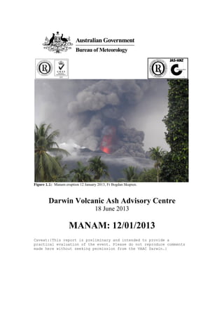
  • 1. Figure 1.1: Manam eruption 12 January 2013, Fr Bogdan Skupien. Darwin Volcanic Ash Advisory Centre 18 June 2013 MANAM: 12/01/2013 Caveat:{This report is preliminary and intended to provide a practical evaluation of the event. Please do not reproduce comments made here without seeking permission from the VAAC Darwin.}
  • 2. 1 Background Figure 1.1 Geographic location of Manam volcano Manam (4°4'48" S and 145°2'14" E, summit elevation 1807m) is a basaltic-andesitic stratovolcano located on the 10-km-wide island of Manam off the northern coast of Papua New Guinea. Four radial valleys extend from the summit and are each located about 90 degrees apart. Manam’s first recorded eruption was in 1616. It has erupted at least 44 times since 1616 until the 12 January 2013 eruption. Most eruptions have occurred in South Crater with eight in both the South and Main Crater. Manam is one of the most active volcanoes in Papua New Guinea. Since 2004, VAAC Darwin has issued 733 advisories for Manam. Its largest recorded eruption was on 23-24 November 2004 as a VEI-4 on the Volcanic Explosivity Index (VEI). Figure 1.2 VAAC Darwin Volcanic Ash Advisories since 2004
  • 3. 2 Discussion 2.1 Eruption Summary Very mild activity was observed from Manam in the Southern crater between 8-11 January. Thin dark grey ash clouds were observed occasionally until early on the 12th . Seismicity to start the period was low on 8 January with a Real-time Seismic Amplitude Measurements (RSAM) of 80, but increased to the moderate levels of 200 by the 11th . The RSAM reached 550 on 12 January between 0000-0100Z and coincided with the commencement of a small sub-plinian eruption according to Rabaul Volcano Observatory (RVO). A peak RSAM of 620 was reported at 1300 UTC on 12 January. The Main Crater remained quiet with only thin to thick white vapour emissions. The eruption was not visible on MTSAT-2 until 0232 UTC due to meteorological cloud from the monsoonal flow. Moderate to strong winds from the northwest to the northeast blew the ash plumes to the southwest, south and southeast. Satellite analysis indicates the initial ash cloud to the southeast rose approximately 6km ASL (20,000ft) by 0532 UTC. A larger eruption near 0400 UTC spread west from Manam and rose to approximately 14km ASL (45,000ft) by 0532 UTC. Continuous forceful projections of moderate thick dark grey ash clouds occurred until 0600 UTC. Ground reports indicate that the ash cloud height was observed to 1500m above the summit or 3307m ASL (11,000ft). After 0600 UTC, ground reports indicated ash plume heights were to 500m above the summit or 2307m ASL (7,500ft). Incandescent lava fragments were visible during the eruption. From 13-14 January, there were occasional to regular emissions of thick to thin ash clouds that were grey to dark in colour. Polygons began to be dropped starting with the 13 January Volcanic Ash Advisory at 0247 UTC. Meteorological cloud made if difficult to verify ash, but clearing was evident to the west for SFC/FL400 and to the south from SFC/FL200. The ash dispersion model seemed to overdo the ash boundary and the VA forecaster scaled back the Fig. 2.1 Manam erupting 12 Jan 2013, Fr. Bogdan Skupien Figure 2.2 Manam. 12 Jan 2013, approximately 2230 UTC, 20 hours after eruption began. Fr. Bogdan Skupien
  • 4. polygon with the evidence of clearing. The final advisory was issued on 13 January at 1928 UTC. 2.2 VAAC Darwin Advisories The eruption was first identified to VAAC Darwin at 0545 UTC in a call from an airline. An Urgent Initial Advisory was issued at 0555 UTC after it was determined Manam was erupting. The forecaster saw what appeared to be storm activity near the volcano that did not fit the pattern of convection. A dispersion forecast model was run to 55,000ft (FL550) to determine the track of the ash after the Urgent Initial. A second pilot report was received at 0600 UTC from another airline identifying Manam and ash to FL500. The MTSAT-2 VIS image from 0432 UTC was used to determine the ash cloud height as be 40,000ft (FL400) using a brightness temperature of 225K (-48C) and the Manus 12/0000 UTC sounding. Movement was based on the model run and Manus upper winds. Figure 2.3 12 January 2013 MTSAT-2 IR 0432 UTC, The original plume southeast of Manam remains visible as it reaches Papua New Guinea’s coastline. Winds spread ash to the south. Before the follow up advisory was sent a new MTSAT image became available. On the MTSAT-2 IR 0532 UTC, using the brightness temperature of 209K (-64C) the ash cloud height was 45,000ft ASL. The plume height was changed to FL450 and the advisory sent at 0625 UTC.
  • 5. Figure 2.4 12 January 2013 MTSAT-2 IR 0532 UTC, depicting ash clouds extending to the west and east of Manam. Figure 2.5 Manus 0000 UTC 12 Jan 2013 sounding. In the follow up advisory at 0625 UTC/12 January, detailed information was given providing the information sources and the movement of the ash in two separate polygons to the west at 45,000ft (FL450) and to the southeast at 20,000ft (FL200). Polygons were advanced forward in the 1230 UTC advisory, to match the ash dispersion forecast. Meteorological cloud cover near Manam made it difficult to identify volcanic ash movement overnight. In the 1815 UTC advisory, the 2 layer polygons were maintained from the previous advisory with the 15 KT NW monsoon steering the SFC/FL200 plume and the SE steering wind for the ash to FL450. The 2303 UTC advisory adjusted the polygons using the VDIFF 2100 UTC imagery. There was a suspicious cloud to the north in addition to considerable meteorological cloud in the area.
  • 6. Fig. 2.6 MTSAT-2 IR 2332 UTC, 12 January 2013. Meteorological cloud around Manam made it difficult to determine the extent of the ash. Figure 2.7: Volcanic Ash Advisory Graphic issued by Darwin VAAC at 2303 UTC on 12 January.
  • 7. New satellite images confirmed that the area of volcanic ash was diminishing. The polygons for SFC/FL 400 and SFC/FL200 were both downgraded. There was clearing evident on the FY-2 13/0201 UTC satellite to the west and south of Manam. Volcanic ash was visible in some areas, but was difficult to determine the exact extent of the ash except in areas free of meteorological cloud. Figure 2.8: Volcanic Ash Advisory Graphic issued by Darwin VAAC at 0247 UTC on 13 January.
  • 8. Figure 2.9 Volcanic Ash Advisory Graphic issued by Darwin VAAC at 0801Z on 13 January. The VA Forecaster cancelled the FL400 polygon due to lack of reports and identifiable volcanic ash on satellite images. No new reports of volcanic ash came in and polygons continued to be downgraded. The final VA Advisory 2013/9 was issued at 1928 UTC on 13 January. 2.3 Pilot Reports VAAC Darwin received a phone call from an airline flying through the region of New Guinea on 12 January at 0545Z. They observed a volcanic ash cloud above FL500 on the north coast of New Guinea. At 0600 UTC, the VAAC received an AIREP from a different airline. The AIREP reported the ash height to be FL500 and identified the volcano as Manam with ash drifting in a westerly direction. AIREP _QBA0182 120600 DD YPDMYMYX YBBBZEZX WIIIYOYX WIIIYNYX RPHIZRZX NZKLYMYX 120600 YSSYQFAO _ARS AIREP SPECIAL VOLCANIC ASH ADVICE FROM QANTAS OPS DESK: 1) AIRCRAFT IDENT:QFA5720 2) A/C TIME/POSN :130534Z AYKK 3) A/C ALTITUDE :FL300
  • 9. 4) VOLC NBR :501-02 5) VOLC ACTIVITY :MANAM S04 05.99 E145 03.66 6) DRIFT OF ASH :WESTERLY 7) AIR TEMP :UNKNOWN 8) SPOT WIND :UNKNOWN 9) PLUME HGT :FL500 10)SUPP INFO :AWTG UPDATE FROM DRW VAAC. 2 AIRCRAFT HAVE REPORTED SAME PLEASE CHECK WITH YOUR OWN SOURCES FOR FURTHER DATA: 2.4 Ground Reports VAAC Darwin was able to visually review Manam’s eruption. Fr. Bogdan Skupien, a Catholic priest travelled from Bogia at 0400 UTC arriving at Bieng-Manam at 0545 UTC. He noted the eruption at 0600 UTC while taking the boat out of the water. At the time he did not notice an earthquake or any sound of a big explosion. He saw the black clouds of ashes and the fire coming out of the volcano simultaneously. The next morning between 2200 UTC and 2300UTC 12 January while coming back from Boisa Island after the morning service Fr. Bogdan took pictures of Manam’s activity. Fig. 2.10 Close up eruption of Manam with ash and lava. 12 January, photo taken after near 0600 UTC. Fr. Bogdan Skupien. 2.5 Volcanological Reports The status of Manam was upgraded to Alert Level II by Rabaul Volcano Observatory (RVO) on 16 June 2012 due to raised levels of activity and seismicity. This included four pyroclastic flows on 16 June 2012. Over the last seven months, the (Department of Mineral Policy & Geohazards Management (DMPGM) has given reports on the activity in their Volcano Information Bulletins on 16 June, 1 July, 1 August, 3 October, 17 October, 25 November, 8 December and 16 December. Activity before the 12 January eruption was high as recorded by the Real-time Seismic Amplitude Measurements (RSAM). A long-term inflationary trend towards the east and continuous volcanic tremors also marked the activity at Manam. “The volcanic tremors and other reported observations suggest the eruptive activity at Southern Crater of Manam is expected to continue. Moreover, discrete phases of stronger
  • 10. strombolian/sub-plinian activity and discrete pyroclastic flows may occur as well.” Prognosis 8/12/12 report DMPGM An email was sent to Rabaul Volcano Observatory (RVO) at 0731 UTC on 12 January inquiring of a high level eruption. Confirmation was received of an eruption at 0812 UTC. Initial reports from RVO indicated that the eruption began around 0300 UTC and increased in intensity between 0500-0600Z. Visible MTSAT-2 images at 0232 UTC confirm the eruption before 0300 UTC. Light ashfall was reported on the mainland generally west of Manam around 0700 UTC. The height of the eruption was reported to be 1500m above the summit (FL110) by the observer. Figure 2.11 12 January 2013 MTSAT- 2 VIS 0232 UTC, The initial eruption of Manam is seen to the southeast. In the Volcano Information Bulletin issued 15 January 2013, RVO reported that a small sub-plinian eruption began at 0000Z on the South Crater 12 January. It peaked between 0200-0300Z. Moderate dark grey ash clouds rose to FL110 (11,000 ft.) lasting approximately 6 hours. Strong NW-NE winds steered the airborne ash plumes to the south. After 0600Z, activity subsided with ash plumes to FL075 (7,500ft). From 13-14 January, there was occasional to regular ash cloud emissions varying from thin and grey to thick and dark. 2.6 Ash Height Calculation During the eruption of Manam, there was a significant difference in heights reported by pilots, satellite and the ground based observer. The eruption which began at 10 am local time peaked around Noon-1 pm before subsiding after 4pm. Darkness was not a factor in the calculation of ash plume height. In the photo to the left, supplied by Fr. Bogdan from the day of the eruption, the max ash plume height cannot be determined. It pushes through the volcanic ash and meteorological cloud in the vicinity. With the monsoonal flow in the region, this could have lifted the volcanic ash to the higher levels as seen on satellite and through pilot reports. Another explanation for the disparity of the height could be the proximity to the eruption. At close range to the volcano crater, it is difficult for a ground Fig. 2.12 Ash plume from Manam pushing through meteorological clouds and volcanic ash clouds. 12 Jan 2013, Fr. Bogdan Skupien
  • 11. based observer to fully view the eruption column and estimate the maximum height. The ground based observer placed the eruption height at 1400-1500m above the summit (10,500-10,900ft ASL). The two aviation reports indicated the height of the ash to be at a much higher level 50,000ft and 50,000ft plus. VAAC Darwin initially analysed satellite data to determine that the height was 40,000ft, but then revised the height to 45,000ft before the advisory was issued when a new satellite image became available. Pilot report 0545 UTC Pilot Report 0600 UTC Ground Observer 0300 UTC Satellite 0532 UTC Height of volcanic ash plume FL500 FL500+ FL110 FL450 Figure 2.13 Cloud cover at Manam Island the afternoon of 12 January 2013. Photo by Fr. Bogdan Skupien between 0400-0545 UTC.
  • 12. Figure 2.14 12 January 2013 MTSAT-2 IR 0532 UTC, depicting ash clouds extending to the west/southwest and southeast of Manam. During the eruption, ash fall was reported in three locations across the island to the west, south and southeast of the volcano. The volcanic ash was picked up on satellite moving to the southeast and to the west/northwest. The VA forecaster used the Manus sounding model from 12/0000 UTC along with MTSAT-2 IR to determine the height of the ash from Manam. The ash to 20,000ft (FL200) was being steered by a NW 15kt monsoon flow while the ash to 45,000ft (FL450) was being steered by an east, southeast wind. 2.7 Aviation Warnings There was only one aviation warning issued during the Manam eruption. NOTAM A0041/13 NOTAMN valid from 12 January 0530 UTC to 31 January 0630 UTC was for ash drifting to the NE at FL200. There was not a NOTAM for ash to FL450. NBA2277 GG YBZZJSTX YBBBVOZX YBBBNOTM 121023 YBBBZEZX (A0041/13 NOTAMN Q)AYPM/QWWXX/IV/BO/W/000/999/ A)AYPM Figure 2.15 12 January 2013 MTSAT-2 VIS 0532 UTC
  • 13. B)1301120530 C)1301310630 EST E)CAUTION VOLCANIC ACT ON MANAM ISLAND (COORD S04 04 40.70 E145 02 15.74) ASH CLD UP TO 20,000FT DRIFT TO NE DIRECTION) There were no SIGMETs issued by PNG. VAAC Darwin received calls from the Brisbane ATC and the NOC Met about the lack of SIGMETs. The Volcanic Ash Meteorologist attempted to contact RVO via phone and email without any success. PNG AirServices was contacted with a fax of the advisory and they responded with a NOTAM to FL200. The NOTAM issued was confirmed at 2200 UTC on 12 January by a pilot on a flight between Madang and Wewak on a climb to F270. Volcanic Ashes were spewing from Manam Island Volcano with the top of the ashes reaching up to F200 and a northeasterly drift. The ashes were not as thick as the previous day. On the 15 January, VAAC Darwin was notified that 0041/13 NOTAMN was still valid. A fax with a copy of our last advisory for Manam (1928 UTC, 13 January) for Manam was sent to the Pt. Moresby MWO and the NOTAM was cancelled. 2.8 Sulphur-Dioxide Data A SACS (Support to Aviation Control Service) multi-sensor warning was received for exceptional SO2 concentration at 1329 UTC 12 January. The region of SO2 was detected by a pass of the satellite IASI EUMETSAT at 1244 UTC. Ash and SO2 can be ejected to similar heights during a high level eruption. As they move away from the volcano they follow a similar distribution pattern with the upper level winds. Meteorological processes cause them to diverge and the amount of ash within a SO2 region diminishes until it becomes negligible. The information received from the SACS multi-sensor warning showed that ash and SO2 were collocated. The SO2/Ash signal that triggered a SACS SO2 alert was slightly west of the current polygon valid at 12/1215 UTC. The SO2/Ash area was covered in the next timestamp at 12/1815 UTC. VAAC Darwin received the alert at 1359 UTC. Meteorological clouds remained in the area due to the monsoonal flow.
  • 14. Figure 2.16 IASI SO2 Image over Papua New Guinea, 1244 UTC 12 January. Figure 2.17 IASI Ash Index Image over Papua New Guinea, 1244 UTC 12 January.
  • 15. Figure 2.18 OMI SO2 ASI Image over Papua New Guinea, 0446 UTC 12 January. 3 Recommendations Recommendation Manam: 120113/1 – That procedures for contacting Pt. Moresby MWO when there is an advisory in their area be included in the VAAC Darwin Volcanic Ash Directive. Communication challenges between Pt. Moresby MWO and VAAC Darwin have resulted in SIGMETs not being issued or cancelled within a timely manner. Since communication channels are not always reliable, one approach is to fax the advisory to them after it is issued. The receipt of information is confirmed by fax and they have access to the information that they need to issue appropriate SIGMETs. Recommendation Manam: 120113/2 – Expand the role of SPOCS within the RFC to serve as quality control in the VAAC. During high level eruptions, they are to ensure that forecasters send out Urgent Initial and Follow Up Advisories within a timely manner. Aviation clients have stressed the importance of getting the message out first than fine-tuning it. VA forecasters when first alerted to a high level eruption should issue an Urgent Initial Advisory as soon as possible and then follow up with a detailed advisory within 20 minutes. During the initial stages of an eruption, the flight level
  • 16. may change as more information is available from sources. It can then be fine tuned in the next advisory with the additional sources input. Valuable time should not be spent changing an advisory before it is issued from a FL400 to a FL450. Airlines will not be flying through this area and it is more important to meet the 20 minute deadline detailing the ash location and forecast. Recommendation Manam: 120113/3 – Update the Volcanic Ash Directive that for high level eruptions, the VA forecaster needs to start work on the update for an advisory no less than 1 hour before the reissue time. When an advisory is not updated for a high level eruption within the 6 hour timeframe, VAAC Darwin is not providing the level of service it should for its clients. Clients begin to call and that slows down the process even further. There are many obstacles that a VA forecaster can run into when preparing an advisory update. Some sources of information may not be available or satellite information can be inconclusive and additional sources of data will need to be investigated. By starting 1 hour before the VAA is due, this will allow the VA Forecaster adequate time to investigate all available date to complete the advisory within the timeframe. Recommendation Manam: 120113/4 – Provide follow up training with forecasters to address formatting issues with advisories. In review of the Manam 12 January 2013 eruption, it was discovered that some VA advisories were not being correctly formatted. Follow up training to be conducted to address formatting errors and ensure that clear and informative products are issued by the VAAC.
  • 17. A. Urgent Initial Advisory VA ADVISORY DTG: 20130112/0555Z VAAC: Darwin VOLCANO: Manam 0501-02= PSN: S0405 E14502 AREA: New Guinea-NE of SUMMIT ELEV: 1807M ADVISORY NR: 2013/1 INFO SOURCE: AVIATION COLOUR CODE: NIL ERUPTION DETAILS: OBS VA DTG: OBS VA CLD: VA NOT IDENTIFIABLE FM SATELLITE DATA FCST VA CLD +6HR: NO VA EXP FCST VA CLD +12HR: NO VA EXP FCST VA CLD +18HR: NO VA EXP RMK: A MORE DETAILED ADVISORY WILL FOLLOW AS SOON AS POSSIBLE. NXT ADVISORY: NO LATER THAN 20130112/1145Z B. Volcanic Ash Advisory (VAA) VA ADVISORY DTG: 20130112/1230Z VAAC: Darwin VOLCANO: Manam 0501-02= PSN: S0405 E14502 AREA: New Guinea-NE of SUMMIT ELEV: 1807M ADVISORY NR: 2013/3 INFO SOURCE: PILOT REPORT, MTSAT2, NOAA AVIATION COLOUR CODE: RED ERUPTION DETAILS: ERUPTION LAST OBS TO FL450 AT 12/0530Z OBS VA DTG: 12/1215Z OBS VA CLD: SFC/FL200 S0345 E14450 - S0405 E14605 - S0430 E14515 - S0410 E14420 - S0345 E14450 MOV W 15KT FL200/450 S0435 E14445 - S0355 E14535 - S0255 E14130 - S0405 E14115 - S0435 E14445 MOV W 15KT FCST VA CLD +6HR: 12/1815Z SFC/FL200 S0355 E14440 - S0435 E14400 - S0535 E14550 - S0440 E14635 - S0355 E14440 FL200/450 S0435 E14445 - S0355 E14535 - S0230 E13835 - S0340 E13810 - S0435 E14445 FCST VA CLD +12HR: 13/0015Z SFC/FL200 S0345 E14445 - S0500 E14250 - S0615 E14725 - S0515 E14745 - S0345 E14445 FL200/450 S0435 E14440 - S0355 E14530 - S0155 E13615 - S0310 E13545 - S0435 E14440 FCST VA CLD +18HR: 13/0615Z SFC/FL200 S0345 E14440 - S0510 E14215 - S0645 E14825 - S0530 E14905 - S0345 E14440 FL200/450 S0435 E14445 - S0355 E14535 - S0155 E13615 - S0310 E13550 - S0435 E14445
  • 18. RMK: HEIGHT DERIVED FROM 12/0530Z MTSAT2 IR IMAGE AND MANUS 12/0000Z SOUNDING, MOVEMENT BASED ON MODEL RUN AND MANUS UPPER WINDS. NXT ADVISORY: NO LATER THAN 20130112/1815Z C. VAA Downgrading Polygons VA ADVISORY DTG: 20130113/0247Z VAAC: Darwin VOLCANO: Manam 0501-02= PSN: S0405 E14502 AREA: New Guinea-NE of SUMMIT ELEV: 1807M ADVISORY NR: 2013/6 INFO SOURCE: MTSAT2, FY AVIATION COLOUR CODE: RED ERUPTION DETAILS: VA LAST OBS TO FL400 AT 12/1700Z OBS VA DTG: 13/0245Z OBS VA CLD: SFC/FL200 S0355 E14500 - S0420 E14800 - S0600 E14710 - S0425 E14435 - S0355 E14500 MOV SE 20KT SFC/FL400 S0345 E14525 - S0225 E14250 - S0400 E14210 - S0425 E14445 - S0345 E14525 MOV NW 15KT FCST VA CLD +6HR: 13/0845Z SFC/FL200 S0355 E14505 - S0435 E14935 - S0615 E14805 - S0435 E14420 - S0355 E14505 SFC/FL400 S0350 E14520 - S0145 E14155 - S0355 E14105 - S0435 E14435 - S0350 E14520 FCST VA CLD +12HR: 13/1445Z SFC/FL200 S0355 E14455 - S0410 E15125 - S0655 E14840 - S0445 E14410 - S0355 E14455 SFC/FL400 S0330 E14525 - S0100 E14120 - S0400 E14015 - S0435 E14425 - S0330 E14525 FCST VA CLD +18HR: 13/2045Z SFC/FL200 SFC/FL400 NO VA EXP RMK: HEIGHT FROM 12/1700Z NOAA AND MANUS 12/1100Z SOUNDING, MOVEMENT BASED ON MODEL AND MANUS SOND. DOWNGRADED POLYGON FL400 AND FL200 DUE TO SAT IMAGE FY 13/0201Z INDICATING CLEARING W AND S. VA MAY STILL BE PRESENT IN AREAS WITH METEOROLOGICAL CLOUD. NXT ADVISORY: NO LATER THAN 20130113/0845Z D. SACS SO2 Alert Email -----Original Message----- From: SACS [mailto:sacs@aeronomie.be] Sent: Saturday, 12 January 2013 11:29 PM
  • 19. To: sacs@aeronomie.be Subject: SACS warning -- IASI -- 2013/01/12 13:58 -- region 311 SACS multi-sensor warning of exceptional SO2 concentration ========================================================== Process date : 2013/01/12 Process time : 13:58 UTC Instrument : IASI Warning region: 311 --------------------- http://sacs.aeronomie.be/IASIalert/2013/01/alertsIASI_20130112_12h44_ 311.php?alert=20130112_135811_311 Date : 2013/01/12 Time : 12:44 UTC Longitude : 141.5 deg. Latitude : -3.7 deg. SZA : 141.6 deg. Max. SO2 dbt : 3.2 K < Super Region 2 >