
Recommended
Recommended
More Related Content
Similar to Public grievance redressal system
Similar to Public grievance redressal system (20)
More from Charles D'souza
Recently uploaded
Recently uploaded (20)
Public grievance redressal system
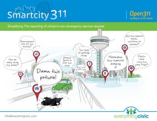
- 1. everythingcivicinfo@everythingcivic.com Simplifying The reporting of citizen’s non-emergency service request
- 2. rakesh@spaceotechnologies.com everythingcivic We build city-branded SmartCity-311 Mobile Apps which allow city government and citizens to work together in non-emergency situations for the betterment of the community. info@everythingcivic.com
- 3. How Does SmartCity-311 App work? everythingcivicinfo@everythingcivic.com Spot Snap Solve
- 4. Citizens use the SmartCity-311 mobile app to connect with local government. The need and desire for civic and government agencies to be more intricately connected is growing rapidly. And thanks to the development of online initiatives like e-Democracy, Gov. 2.0 and the Open Government Initiative, the ability to do so is becoming a reality to cities, towns and communities everywhere. everythingcivicinfo@everythingcivic.com
- 5. EverythingCivic is able to provide these services to all non-emergency services through its web and mobile platform, providing civic agencies with the capability to gather, track, analyze, store and publish civic-related data and information. everythingcivicinfo@everythingcivic.com GPS-enabled Smartphones GeoTag the photos, work crews/ officers can locate the problem without requiring a citizen to enter the address information
- 6. Our system has two modules everythingcivicinfo@everythingcivic.com CRM (Citizen Relationship Management) Suite for Government / Municipal councils Our Mobile 311 City branded App. Available on
- 7. For Citizens: Our Mobile 311 City branded App: everythingcivicinfo@everythingcivic.com SmartCity-311 apps are available for iPhone and Android phones and are extremely easy to use. Reporting an issue using the following quick and easy process… • Citizens install the FREE SmartCity-311 app on their smartphone. • Citizens observe an issue such as a pothole or a corner full of garbage. • Citizens capture a photo of the issue using the built-in Camera functionality of the app. • Citizens choose from the menu for submitting the photo to the proper agency. Garbage, Roads, Health Issues, Dangerous Conditions, Redevelopment, Police Issues, Environment Issues, Noise Complaints and other categories are available. • Citizens have the option to add written comments regarding the issue. • Citizens submit the issue by pressing the SUBMIT icon. • Using the GPS in the phone, the application appends location and time-stamp information for each report, which is then sent to the central server.
- 8. For Government / Municipal councils: Citizen Relationship Management (CRM) Suite everythingcivicinfo@everythingcivic.com Our Cloud-based Web-hosted for Municipal Corporation is a Citizen Relationship Management (CRM) Suite, which is based on Open311 Protocol & API. The idea behind it is simple. Everything is as automated as possible, and for those things that aren’t, an efficient non-technical user interface eliminates duplication of work. FOR EXAMPLE: • A Government official log's into our Cloud CRM. • Based on Rank & Department, he sees the list of issues reported by citizens and which belong to his/her geographies. • They can view photos of the issue, view a mapped location of the issue, assign communication and resolution of the issue to the proper staff, acknowledge/update/close issues from the CRM or Field Officer. The mobile app will also generate automated email notifications to residents when requests are updated/closed. • The Open311 protocol API allows for dynamically updating all citizen engagement channels (websites, Facebook or Twitter), exports data, generates reports by date range and visualizes data via the map tab. • Using our inbuilt Workflow management Tools work order tickets for service teams or contractors can also be produced.
- 9. everythingcivicinfo@everythingcivic.com Business Intelligence (BI) Module: Our BI tool makes it simple to pour through a serious amount of data to create charts and graphs, highlighting everything from trends over time to the volume of reports. Heat-maps Module in our CRM: The heat-map is one of the fastest and easiest ways to visualize geographical data on a map. Below is the sample heat-map showing density of new roads built in Ahmedabad by engineering department.
- 10. info@everythingcivic.com/Everythingcivic everythingcivic.com@everythingcivic follow us Our Goal everythingcivic Our goal is to Cultivate Positive and Productive Civic Practices using modern technology Innovatively and build systems & Solutions around it.