1. 4. Acknowledgements
1. Overview 2. Work-Flow
Caspar Chung*, Jyoteshwar R Nagol*, Jan Dempewolf, Xin Tao, Anupam Anand
Global Land Cover Facility, University of Maryland. *cchung7@umd.edu, jnagol@umd.edu
Hierarchical Object-Based Image Analysis Approach for Classification
of Sub-Meter Multispectral Imagery in Tanzania
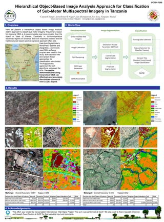
Image Segmentation
Coarse Scale
Segmentation
Fine Scale
Segmentation
Estimation of Scale
Parameter (ESP Tool)
Data Preparation
Ortho-rectified Raw
Imagery
Image Calibration
NDVI layer
Generation
Pan Sharpening
DEM (Resampled)
Classification
Decision Tree
(Random Forest) based
Image Classification
Training Data Collection
QA/QC
Feature Selection for
Classifier Training
3. Results
Data from DigitalGlobe's
WorldView2 satellite and
eCognition, a commonly
used OBIA software
program was used for this
study. Both decision tree
and random forest
approaches for
classification were tested.
The Kappa index
agreement for both
algorithms surpassed the
85%. The results
demonstrate that using
hierarchical OBIA can
effectively and accurately
discriminate classes at
even LCCS3 legend.
Here we present a hierarchical Object Based Image Analysis
(OBIA) approach to classify sub-meter imagery. The primary reason
for choosing OBIA is to accommodate pixel sizes smaller than the
object or class of interest. Especially in nonhomogeneous
savannah regions of Tanzania, this is an important concern and the
traditional pixel based spectral signature approach often fails.
Mahenge Overall Accuracy: 0.967 Kappa: 0.958
Decision tree level/Types of features Spectral Geometry Texture Neighbor Super/Subobjects Soil DEM
High level (1st to 5th node) 7(25%) 2(15.3%) 0 2(50%) 1(33.3%) 0 1(100%)
Medium level (6th to 10th node) 18(64.2%) 6(46.1%) 5(83.3%) 2(50%) 2(66.6%) 3 (75%) 0
Low level (11th to 14th node) 3(10.7%) 5(38.4%) 1(16.6%) 0 0 1(25%) 0
Total 28 13 6 4 3 4 1
Malangali Overall Accuracy: 0.949 Kappa:0.932
Decision tree level/Types of features Spectral Geometry Texture Neighbor Super/Subobjects Soil DEM
High level (1st to 3rd node) 2(20%) 0 1(25%) 0 0 0 0
Medium level (4th to 8th node) 6(60%) 2(66.6%) 1(25%) 2(50%) 0 2(66.6%) 0
Low level (9th to 11th node) 2(20%) 1(33.3%) 2(50%) 2(50%) 1(100%) 1(33/3%) 1(100%)
Total 10 3 4 4 1 3 1
Legend
Agriculture
Rock/gravel
Soil
Road
Roof
Riparian trees
Trees
Shrubland
Grass
Water
Tree shadow
Cloud/shadow
This effort was funded by Conservation International, Vital Signs Project. The work was performed at GLCF. We also want to thank Saurabh Channan
and Joseph Owen Sexton at GLCF for their valuable input and comments.
GC13H-1250
Legend
Agriculture
Rock/gravel
Soil
Road
Trail
Roof
Riparian trees
Trees
Shrubland
Grass
Water
Shadow