TESMAP AND TESTOPO

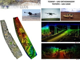
TESMAP - Seabird Aerial Mapping Last week, 4th of June, specialist geospatial and geoscience solutions company, Total Earth Solutions (TES), with its aviation partner, helicopter company Heliwest, carried out a detail photogrammetry survey of the Seabird seafront, using cutting edge Drone technology. Heliwest, Western Australia’s largest helicopter company, operates a Lockheed Martin “Indago” survey drone for a variety of applications including night time surveillance of bush fires as witnessed last fire season in Perth, and a recent UN project where the unit was used in disaster relief immediately following the cyclone in Vanuatu. The Indago differs from the cheap hobby drones that are becoming common by its robust military spec construction and highly sophisticated navigation and control systems that allow it to operate in all conditions and to remain sufficiently stable and vibration free in autonomous flight for high resolution photography to be used for quantitative mapping purposes. As part of a testing program, TES and Heliwest offered to fly the Seabird seafront for the Shire of Gin Gin at no cost and to make the data available to the council and interest groups to assist in remediation efforts and to demonstrate the application of the technology to coastal erosion problems. The UAV flies low at approximately 100m above the ground, along pre-pre-programmed flight lines, taking hi-resolution overlapping photographs. Objects and features are photographed from different angles in adjacent frames, allowing a 3 dimensional terrain surface to be created, that with appropriate ground control can be accurate to several cm. The creation of 3D models from airborne photography is not new, but the introduction of high quality drones has changed the economics of these surveys. Previously photographs were taken from aircraft at high altitude requiring enormous cameras valued at over $1m. Such surveys are still commonplace, but are only suited to large regional surveys as the operating economics of the aircraft make them prohibitively expensive for small areas. Flying low and slow, a drone can utilise a much smaller camera, and yet achieve much higher resolution than an aircraft, especially for high angle beach slopes. More importantly, the operating economics of drones are better suited to detailed mapping of smaller features, such as Seabird, allowing problem areas are be re-surveyed at regular intervals to map precisely how coastal areas change with time. Drones are not new, but this survey exemplifies the difference between cheap hobby machines that take photographs and survey quality machines that collect data. Advances continue with larger drones soon to be introduced by TES and Heliwest to carry portable laser scanning (LIDAR) units for even more detailed mapping of complex features, with applications in mining, civil and environmental mapping. Brett M. Johnson Principal/Director Total Earth Solu

Recommended
More Related Content
More from Brett Johnson
More from Brett Johnson (20)
Recently uploaded
Recently uploaded (20)
TESMAP AND TESTOPO
- 1. TESMAP – UAV ORTHOIMAGERY TESTOPO – UAV LIDAR