1. DS-T
DS-T
DS-T
DS-T
DS-T
DS-T
DS-T
DS-T
DS-T
DFL
DFL
MS
DS-T
DS-T
DS-T
DS-T
DS-T
DS-T
DS-T
MS
RS-T
RS-T
DS-T
DS-T
EF
DS-T
DS-T
DS-T
DS-T
MS
DS-T
DS-T MS
DS-T
DS-T
DS-T
EF
DS-T
DFL
DF-S
DFL
DS-T
DS-T
EF
DS-T
DS-T
DS-T
DS-T
DS-T
DS-T
DS-T
RF
DS-T
MS
DS-T
MSDS-T
DS-T
DS-T
MS
RS-T
DS-T
DS-T
DS-T
EF
DS-T
RS-T
DS-T
RS-T
DS-T
DS-T
DS-T
EF
RF
OC
DS-T
MS
EF
DFL
DS-T
DS-T
DS-T
DS-T
DFL
DS-T
DS-T
DS-T
DS-T
RS-T
DS-T
RS-T
MS
MS
RS-T
DS-T
OC
RF
DS-T
MS
DS-T
DS-R
DS-T DS-T
DS-T
DS-T
MS
DS-T
DS-T
DS-T
DS-T
DFL
RF
DS-T
RF
RF
DFL
RF
MS
DS-T
DFL
RF
OC
RF
DS-T
MS
DFL
DS-T
DFL
DS-T
DS-T
MS
DS-T
DS-T
MS
DS-T
DS-T
DS-T
DFL
DF-S
DS-T
EF
DFL
RS-T
MS
DS-TMS
DFL
DS-T DS-T
DS-T
EF
DS-T
DS-T
DS-T DFL
DS-T
DS-T
EF
DFL
DS-T
DS-T
MS
DS-T
DS-T
MS
DS-T
MS
DS-T
EF
DS-T
DS-TDS-T
MS
DS-T
DS-T
DS-T
DS-T
MS
DS-T
DS-T
DS-T
DF-S
DFL
DS-T
DS-T
DS-T
DS-T
DS-T
DS-T
MS
DS-T
DS-T
MS
DS-T
DS-T
MS
DS-T
DS-T
RS-T
DS-T
MS
DF-S
DFL
DFL
DS-T DS-T
MS
DS-T
DS-T
MS
DS-T
DS-T
DS-T
DS-T
DS-T
DS-T
MS
DFL
DS-T MS
DS-T
DS-T
OC
RF
DS-T
DS-T
RF
DS-T
DS-T
DS-T
DFL
DS-T
EF
DS-T
DS-T
DS-T
MS
DS-T
DS-T
DFL
RS-T
MS
MS
DS-T
DS-T
DS-TDS-T
DS-T
RS-T
RF
DFL
DS-T
MS
MS
EF
DS-T
DS-T
DS-T
DS-T
DS-T
DS-T
DS-T
DS-T
DS-T
MS
DS-T
OC
OC
RS-T
OC
MS
DS-T
DS-T
DS-T
DFL
RS-T
DF-C
OC
RF
OC
DS-T
OC
RF
OC
DFL
DS-T
DS-T
DS-T
DS-T
MS
DFL
DS-T
DS-T
RF
DS-T
DS-T
DS-T
DS-T
MS
DS-T
DFL
DFL DS-T
DS-T
DS-T
MS
MS
DS-T
RS-T
DS-T
DS-T DS-T
DS-T
RS-R
DS-T
DS-T
DS-T
MS
DS-T
DS-T
DS-T
DFL
DS-T
DS-T
MS
EF
DS-T
DS-T
MS
DS-T
MS
DS-T
DS-T
DS-T
MS
DS-T
DS-T
RS-T
DS-T DS-T
DS-T
DS-T
DS-T
DS-T
DS-T
DS-T
DS-T
MS
DS-T
MS
DS-T
MS
DFLDS-T
DS-T
DS-T
DS-T
DS-T
RF RF
OC
OC
RF
OC
DS-T
OC
MS
DS-T
DS-T
MS
RF
MS
DS-T
DS-T
DS-T
MS
DS-T
MS
MS
MS
OC
DS-T
MS
MS DFL
DS-T
DS-T
DS-T
MS
DFL
DS-T
DS-T
DS-T
DS-T
DS-T
DS-T
DS-T
DS-T
DS-T
DS-T
DS-T
MSDS-T
DS-T
DS-T
DS-T
MS
DS-T
DF-S
DS-T
DS-T
DS-T
DS-T
DS-T
DS-T
DS-T
DS-T
DFLDFL
OC
Sixmile Creek
North Hollow-Twelvemile Creek
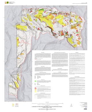
UTAH GEOLOGICAL SURVEY
a division of
Utah Department of Natural Resources
in cooporation with the
United States Forest Service
Plate 1
Utah Geological Survey Map 273DM
Landslide Inventory Map of the Sixmile Canyon and North Hollow Area, Sanpete County, Utah
MAP LOCATION
FERRON
RESERVOIR
MAYFIELD WOODS LAKE
HELIOTROPE
MTN
STERLING
BLACK
MOUNTAIN
INDEX TO U.S. GEOLOGICAL
SURVEY 7.5' QUADRANGLES
CONTOUR INTERVAL 40 FEET
SCALE 1:24,000
2 0 21
Miles
2 0 21
Kilometers
LANDSLIDE INVENTORY MAP OF THE SIXMILE CANYON AND NORTH HOLLOW AREA,
SANPETE COUNTY, UTAH
By
Gregg S. Beukelman, Ben A. Erickson, and Richard E. Giraud
2015
APPROXIMATE MEAN
DECLINATION, 2015
TRUENORTH
MAGNETICNORTH
11° 33'
Base from USFS Black Mountain, Ferron Reservoir, Sterling,
Projection: UTM Zone 12
Datum: NAD 1983
Spheroid: Clarke 1866
Program Manager: Steve D. Bowman
Project Manager: Richard E. Giraud
GIS and Cartography: Jay C. Hill and Gordon E. Douglass
Utah Geological Survey
1594 West North Temple, Suite 3110
P.O. Box 146100, Salt Lake City, UT 84114-6100
(801) 537-3300
geology.utah.gov
Mayfield and Woods Lake 7.5'Quadrangles 2012
EXPLANATION
This map presents a landslide inventory of part of the Sixmile Canyon and North Hollow area, Sanpete
County, Utah, at a scale of 1:24,000. The purpose of the map and accompanying geodatabase is to show and
characterize prehistoric and historical landslides larger than about 120 feet across their shortest dimension, and
to provide information useful for managing landslide problems. The map and accompanying geodatabase were
prepared by the Utah Geological Survey (UGS) as a cooperative project with the Manti-La Sal National Forest.
The map covers 42 square miles on the west side of the Wasatch Plateau, and includes parts of two hydrologic
units: 33 square miles in the Sixmile Creek Hydrologic Unit (hydrologic unit code no. 160300040502) and 9
square miles in the northern part of the North Hollow-Twelvemile Creek Hydrologic Unit (hydrologic unit code
no. 160300040404) (hydrologic unit boundaries from Utah Automated Geographic Reference Center, 2012).
We used geographic information system (GIS) software to capture, store, and display the data for each mapped
landslide.
Manti-La Sal National Forest boundary
Hydrologic unit boundary
We prepared the landslide inventory by analyzing and interpreting 12 different sets of stereo and
orthophoto aerial photography acquired periodically from 1940 through 2011, which provide a 72-year history
of landsliding in the area. We cite photography dates and scale in our aerial photographs reference list. We
recorded spatial and tabular data for each mapped landslide. Spatial data pertain to landslide deposit and
landslide geomorphic source type; source types include slide and flow main scarps, rockfall cliff bands and
outcrops, and debris-flow source areas and channels. Tabular data describe landslide characteristics in text or
numeric form. The spatial and tabular data are stored in the geodatabase and linked to the inventory map. Land-
slide information stored in the geodatabase includes area, material type, movement type, landslide deposit name,
landslide source name, movement activity, thickness, movement direction, approximate movement dates,
geologic unit(s) associated with the landslide, confidence in mapped boundaries, mapper name, peer reviewer
name, and comments.
Landslide Classification
The characteristics used to classify landslides were observed on aerial photography of various dates,
on topographic quadrangle maps, in Manti-La Sal National Forest reports, and in the field. Our landslide classi-
fication methodology is similar to that used by the California Geological Survey (Irvine and others, 2007) and
the Oregon Department of Geology and Mineral Industries (Burns and Madin, 2009). Landslide classification
is based primarily on terminology and mapping criteria of Varnes (1978), Wieczorek (1984), Cruden and Varnes
(1996), Keaton and DeGraff (1996), and Haskins and others (1998). Landslide deposits are classified based on
type of geologic material and type of movement. Where a landslide source could be identified and mapped, the
source was classified based on the geomorphic source type. Both the landslide deposit and source were further
classified based on landslide movement activity and boundary-mapping confidence. The geodatabase includes
additional landslide information not shown on the map.
Landslide Deposit Materials and Movement
Each landslide deposit is assigned a two-part name based on dominant material type and movement
type after Cruden and Varnes (1996). The material is classified as rock or soil, and soil is further subdivided as
debris (mostly coarser than sand-sized particles) or earth (mostly sand-sized or finer particles). The observed
movement types in the Sixmile Canyon and North Hollow area consist of falls, flows, and slides (rotational and
translational). We used the following landslide names in our mapping:
RF rockfall
RS-R rock slide, rotational
RS-T rock slide, translational
DS-R debris slide, rotational
DS-T debris slide, translational
DFL debris flow
EFL earth flow
Landslide Source Type
Landslide source areas are classified based on geomorphic source type. Cliff bands and
outcrops are typically the source areas for rockfall deposits. Main scarps are typically the
source area for slide and flow deposits. A debris-flow source is an eroded area above the
deposit. A debris-flow/channel is the scoured path the debris flow has taken from its source to
the deposit. We identified the following landslide source types in our mapping:
CB cliff band
OC outcrop
MS main scarp
DF-S debris-flow source
DF-C debris-flow/channel
Landslide Movement Activity
We classified landslide deposits based on landslide features observed on aerial photographs and/or in
the field.
Active or historical: The landslide has documented movement or landslide features observed
on aerial photography and/or in the field indicative of historical movement.
Dormant or very-slow moving: Landslide-deposit landforms are fresh or uneroded, but there
is no evidence of historical movement. Landslide movement is suspended or at a slow rate
preventing development of sharp recognizable features associated with active movement and
allowing erosion to smooth existing features.
Dormant-eroded: Landslide-deposit landforms are smoothed, subdued, and incised by
erosion.
Landslide Mapping Confidence
The confidence of landslide mapping is based on the visual clarity of boundaries around source and
landslide deposits. Erosion or vegetation may obscure boundaries, making them difficult to map accurately.
High: The landslide boundary is clearly evident and discernable. The landslide generally
shows features indicative of recent movement.
Moderate: Some, but not all, parts of the boundary are clearly evident, other parts are approxi-
mate or gradational. Diagnostic landforms are generally present.
Low: The boundary is difficult to determine and is approximately located, and few diagnostic
landforms may be present.
Geology and Landslides in the Sixmile Canyon and North Hollow Area
The Sixmile Canyon and North Hollow area lies on the western side of the Wasatch Plateau. Previous
geologic mapping of the area includes the 1:24,000-scale geologic map of the Sterling 7.5’ quadrangle (Weiss,
1994) and the 1:100,000-scale geologic map of the Manti 30’ x 60’ quadrangle (Witkind and others, 1987). The
geologic units exposed within the area consist of, from oldest to youngest, Cretaceous Price River Formation,
Tertiary-Cretaceous North Horn Formation, Tertiary Flagstaff Limestone, Tertiary Colton Formation, and
Quaternary moraine (Witkind and others, 1987). The Price River Formation contains sandstone and shale. The
North Horn Formation is primarily shale with lesser amounts of sandstone. Shale in the North Horn Formation
commonly weathers to clay and typically produces more landslides than the other rock units on the Wasatch
Plateau (McDonald and Giraud, 2011). The Flagstaff Limestone contains shale and limestone. The Colton
Formation commonly contains claystone and mudstone. Quaternary glacial moraine deposits are composed
chiefly of eroded Flagstaff, and lesser North Horn material, and are found in the upper part of Sixmile Canyon.
Rock units in the eastern part of the map area are generally flat lying and are cut by north-south-trending,
high-angle, small-displacement normal faults. In the western part of the North Hollow area, and the lower part
of Sixmile Canyon, these units dip moderately to the west as part of the Wasatch monocline.
Weak geologic units within the Sixmile Canyon and North Hollow area show evidence of widespread landslid-
ing. The upper part of Sixmile Canyon was glaciated most recently during the Pleistocene (Wilson, 1949;
Larson, 1996) and post-glacial landslides have commonly displaced moraines. Weathered shale of the North
Horn Formation commonly produces the largest landslides. Limestone of the Flagstaff Formation forms a
plateau cap rock that is a common source of rockfall along cliff bands. Our mapping shows that most of the
active landslides are reactivations of pre-existing landslides. Pre-existing landslides are prone to reactivation
due to their weak strength characteristics. Some of these landslides have moved very slowly, inches or less per
year, while others have moved rapidly and traveled miles.
The map area has a long history of damaging landslides. Landsliding and exceptionally high stream
flows in 1983 caused extensive damage to the main Sixmile Canyon Road (USFS Road 50047) (U.S. Forest
Service, 1983) and two of three springs that provided the town of Sterling with its culinary water supply. Land-
slides in the map area have also caused damage to developed areas below the mouth of Sixmile Creek. During
one of these landslide events, Sixmile Creek changed course several hundred yards before it passed beneath U.S.
Highway 89 just north of Sterling. The resulting backup of debris filled the ravine east of the highway, caused
flooding of nearby fields, and deposited layers of silt and sand in low-lying areas.
ACKNOWLEDGMENTS
We thank Greg McDonald, Tyler Knudsen, Steve Bowman, and Jay Hill (Utah Geological Survey) for
their technical review comments. Gordon Douglass and Jay Hill provided GIS and cartographic input and
support. Pete Kilbourne (now retired from the Manti-La Sal National Forest) provided helpful input on map
scoping.
DISCLAIMER
Mapping supported by the Manti-La Sal National Forest, Department of Agriculture, under U.S.
Forest Service Challenge Cost-Share Agreement 10-CS-11041000-033, and the Utah Geological Survey. The
views and conclusions contained in this document are those of the authors and should not be interpreted as
necessarily representing the official policies, either expressed or implied, of the U.S. Government.
Although this product represents the work of professional scientists, the Utah Department of Natural Resources,
Utah Geological Survey, makes no warranty, expressed or implied, regarding its suitability for a particular use.
The Utah Department of Natural Resources, Utah Geological Survey, shall not be liable under any circum-
stances for any direct, indirect, special, incidental, or consequential damages with respect to claims by users of
this product. For use at 1:24,000 scale only. The UGS does not guarantee accuracy or completeness of the data.
REFERENCES
Burns, W.J., and Madin, I.P., 2009, Protocol for inventory mapping of landslide deposits from light detection and
ranging (LIDAR) imagery: Oregon Department of Geology and Mineral Industries Special Paper 42, 24 p.
Cruden, D.M., and Varnes, D.J., 1996, Landslide types and processes, in Turner, A.K., and Schuster, R.L.,
editors, Landslides—investigation and mitigation: Washington, D.C., National Academy Press, National
Research Council, Transportation Research Board Special Report 247, p. 36–75.
Haskins, D.M., Correll, C.S., Foster, R.A., Chatoian, J.M., Fincher, J.M., Strenger S., Keys, J.E., Maxwell, J.R.,
and King, T., 1998, A geomorphic classification system: Washington, D.C., USDA Forest Service, 110 p.
Irvine, P.J., McCrink, T.P., and Willis, C.J., 2007, Landslide hazard mapping by the California Geological
Survey—tools for assessing landslide hazards in California, in Schaefer, V.R., Schuster, R.L., and Turner,
A.K., editors, Conference presentations, 1st North American Landslide Conference, Vail, Colorado: Associa-
tion of Environmental & Engineering Geologists Special Publication, no. 23, p. 603–612.
Keaton, J.R., and DeGraff, J.V., 1996, Surface observation and geologic mapping, in Turner, A.K., and Schuster,
R.L., editors, Landslides—investigation and mitigation: Washington, D.C., National Academy Press,
National Research Council, Transportation Research Board Special Report 247, p. 178–230.
Larson, P.R., 1996, Glacial geomorphology of a portion of the Wasatch Plateau, central Utah: Salt Lake City,
University of Utah, Ph.D. dissertation, 186 p.
McDonald, G.N., and Giraud, R.E., 2011, Landslide inventory map of Twelvemile Canyon, Sanpete County,
Utah: Utah Geological Survey Map 247DM, scale 1:24,000.
U.S. Forest Service, 1983, Flood damage report and funding request to repair or ameliorate the damages caused
by the snowmelt, high water, landslides, and mudflows of the spring and summer 1983: Price, Utah, Manti-La
Sal National Forest unpublished report, 133 p.
Utah Automated Geographic Reference Center, 2012, Utah SGID vector GIS data layers HUC: Online,
<http://gis.utah.gov/sgid-vector-download/utah-sgid-vector-gis-data-layers-by-name>, accessed January 3,
2015.
Varnes, D.J., 1978, Slope movement types and processes, in Schuster, R.L. and Krizek, R.J., editors,
Landslides—analysis and control: Washington, D.C., National Academy of Sciences, National Research
Council, Transportation Research Board Special Report 176, p. 11–33.
Wieczorek, G.F., 1984, Preparing a detailed landslide-inventory map for hazard evaluation and reduction:
Bulletin of the Association of Engineering Geologists, v. 21, no. 3, p. 337–342.
Wiess, M.P., 1994, Geologic map of the Sterling quadrangle, Sanpete County, Utah: Utah Geological Survey
Map 159, scale 1:24,000.
Wilson, M.D., 1949, Geology of upper Sixmile Canyon area, central Utah: Columbus, Ohio State University,
M.S. thesis, 106 p.
Witkind, I.J., Weiss, M.P., and Brown, T.L., 1987, Geologic map of the Manti 30’ x 60’ quadrangle, Carbon,
Emery, Juab, Sanpete, and Sevier Counties, Utah: U.S. Geological Survey Miscellaneous Investigations
Series Map I-1631, scale 1:100,000.
AERIAL PHOTOGRAPHS
Aerial photographs listed here, with the exception of ESRI World Imagery, and the National Agricul-
ture Imagery Program and Google orthophotos, are available online via the UGS Aerial Imagery Collection at
https://geodata.geology.utah.gov/imagery/.
ESRI, 2011, World Imagery orthophotography, ArcGIS online map service, accessed on May 1, 2015.
Soil Conservation Service, 1940, Aerial photography, Project Code COK, frames 1-5 through 8, 1-35 through
40, 1-48 through 52, and 1-78 through 82, dated 8-3-1940; frames 4-34 through 38, dated 8-28-1940, black
and white, approximate scale 1:20,000.
U.S. Forest Service, Intermountain Region, 1983, Manti-La Sal National Forest aerial photography, frames 68
through 103, dated 5-28-1983, color, approximate scale 1:8,500.
U.S. Forest Service, Manti-La Sal National Forest, 1964, Aerial photography, Project Code ENR, frames 9-33
through 36, 9-63 through 67, 9-80 through 84, 9-113 through 116, 9-135 through 139, and 9-175 through 180,
dated 9-11-1964, black and white, approximate scale 1:15,840.
U.S. Forest Service, Manti-La Sal National Forest, 1976, Aerial photography, Project Code 49007, frames
676-192 through 199, 676-230 through 234, 776-9 through 13, 776-44 through 47, 776-64 through 66, dated
7-4-1976, color; frames 776-65 and 776-66, dated 7-4-1976, black and white; frames 776-88 through 92,
dated 8-5-1976, black and white; frames 776-134 through 138, dated 9-28-1976, color, approximate scale
1:15,840.
U.S. Forest Service, Manti-La Sal National Forest, 1984, Aerial photography, Project Code 614101, frames
184-13 through 18, 184-31 through 35, 184-63 and 67, 184-97 through 103, 184-141 through 147, 184-218
through 224, 184-232 through 237, dated 9-9-1984, color, approximate scale 1:12,000.
U.S. Forest Service, Manti-La Sal National Forest, 1991, Aerial photography, Project Code 614100, frames
490-61 through 65, 490-98 through 103, 490-133 through 136, 490-150 through 155, 490-180 through 185,
490-193 through 198, dated 9-25-1991, color, approximate scale 1:15,840.
Utah Automated Geographic Reference Center, 2004, National Agriculture Imagery Program aerial photogra-
phy, Project Code NAIP04, frames 03124-29 through 32, 03232-61 through 64, 03232-190 through 193,
03232-238-241, color, approximate scale 1:40,000.
Utah Automated Geographic Reference Center, 2013, Google imagery color orthophotos: Online,
http://gis.utah.gov/data/googleimagery/, accessed June 2, 2015.
Utah Automated Geographic Reference Center, 2015, U.S. Geological Survey mid-1990s black and white
orthophotos and 2004, 2006, 2009, 2011, and 2014 National Agriculture Imagery Program color orthophotos:
Online, < http://gis.utah.gov/aerial-photography>, accessed January 4, 2015.
Landslide Inventory Map of the Manti Canyon, Ephraim Canyon, and Dry Canyons-San Pitch River Area (in progress)
Landslide Inventory Map of Twelvemile Canyon (UGS Map 247DM)
)ssergorpni(aerAkeerCnorreFehtfopaMyrotnevnIedilsdnaL
111°30'
111°30'
111°32'30"
111°32'30"
111°35'
111°35'
111°37'30"
111°37'30"
111°40'
111°40'
39°12'30"
39°12'30"
39°10'
39°10'
39°7'30"
39°7'30"
39°5'
39°5'
3E2E 3E 4E
19S
18S
19S 4E19S 3E
19S
20S
19S
18S
20S
19S
3E2E