
Recommended
More Related Content
Similar to Streets as Destinations - Canterbury City Council (2008 - 2020)
Similar to Streets as Destinations - Canterbury City Council (2008 - 2020) (20)
Recently uploaded
Recently uploaded (20)
Streets as Destinations - Canterbury City Council (2008 - 2020)
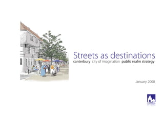
- 1. Streets as destinations canterbury city of imagination public realm strategy January 2008
- 2. Inside cover
- 3. Contents Introduction Key plan of completed and proposed projects 1: St. George’s Street and Iron Bar Lane 2: The Beaney Library and Museum 3: The Marlowe Riverside 4: Connecting the Marlowe Theatre, Beaney Library and the King’s Mile 5: Connecting the West Station with the High Street 6: Connecting the Museum of Canterbury with the High Street 7: Connecting World Heritage Sites 8: Extending the King’s Mile to Northgate 9: The Parade, High Street and St. Peter’s Street Appendices: Estimated breakdown of costs for each project Page 4 5 6 7 8 9 10 11 12 13 15 i - vii 3 The plans based on Ordnance Survey mapping included within this publication are provided by Canterbury City Council under licence from the Ordnance Survey in order to fulfil its public function to act as a planning authority and encourage investment. Persons viewing this mapping should contact Ordnance Survey copyright for advice where they wish to licence Ordnance Survey map data for their own use. © Crown copyright. All rights reserved (Canterbury City Council) (100019614) (2008). Executive summary A fundamental change in the way we think about and design streets is underway. The new Government funded publication Manual for Streets expresses new thinking on the design of streets. It identifies streets as key elements of placemaking and emphasises their role in creating successful, well designed urban centres. CABE supports this shift and recommends a strategic approach to the design and management of public spaces underpinned by robust research and evaluation. Manual for Streets states that principles and objectives for streets should be set out in a public realm strategy. This strategy is Canterbury City Council’s first attempt to develop a coherent framework for the phased upgrading and enhancement of streets and associated public space. This document shows what has already been achieved and what remains to be done. It does this by costing nine key individual projects. Too often street design is dominated by certain stakeholders, resulting in unimaginatively designed streets which have tended to favour motorists over other users. Policy and practice is now moving away from segregation of motorists and civic functions towards a more integrated urban environment. There is economic value in high quality streets. By improving street quality the popularity of the area is raised. CABE’s Paved with Gold study demonstrates a direct link between street quality and property prices. It shows clearly that quality can add at least 5% to the price of homes and to retail rents. The development of this joined up strategy document clearly illustrates what needs to be done to create a network of high quality pedestrian movement routes and spaces in the city. If this can be achieved it will last many years and will see public life enrich the public realm of the city: streets will become destinations not just thoroughfares. Streets as destinations canterbury city of imagination public realm strategy
- 4. Introduction This public realm strategy for Canterbury represents the initial steps towards achieving an urban renaissance in the City of Canterbury. Although the city has inherited and maintained a rich cultural and historic legacy, highlighted by its World Heritage Site status, much of the public realm that provides the setting for the city’s diverse ‘offer’falls short, not only in terms of quality and visual appearance, but also in terms of legible pedestrian routes. Canterbury is a place that has strived to remove the dominance of the motor car from its historic core, whilst attracting visitors as one of the country’s top visitor destinations. The resulting environmental enhancements, carried out over a number of years, have been somewhat piecemeal in nature due to funding issues, and have often focussed on specific areas within the city rather than forming part of an holistic, place-making, urban design strategy. In June 2005 the Yellow Book report ‘canterbury: city of imagination’concluded that urban design should be one of the key themes in an Action Plan to make Canterbury “One of Europe’s most dynamic, attractive and competitive small cities”. Enhancement of the public realm provides the ideal creative catalyst towards achieving the ‘vision’for Canterbury. The multi-disciplinary nature of this approach, the underlying urban design principles of connectivity, adaptability, legibility, permability, and an understanding of the social and economic implications of design and planning decisions reaches beyond simple repaving schemes. The combination of a ‘pedestrian friendly’network of ‘living places’and high quality public realm will encourage a vibrant mix of activities and multifunctional services, accessible to both visitors and residents, that would further promote cohesion, inclusion and equal opportunities within the city. Over the past 17 years Canterbury City Council has undertaken a number of public realm enhancement projects throughout the city using high quality, natural materials. The use of such long lasting materials ensures the local distinctiveness of the city is maintained in a sustainable manner. 4 Aims of the strategy The aim of this public realm strategy for Canterbury, building on those projects already completed, is to create a legible network of streets and spaces that not only afford permeable connections to each other and the wider city, but also become destinations in their own right. Objectives To encourage people to walk and cycle rather than drive. To strengthen the city’s unique historic sense of place. To encourage the development of a series of destinations within the city. Purpose of this document To help secure external partnership funding. To provide the ‘bigger picture’and enable individual schemes to be prioritised and implemented progressively. Tower House (committed project) due 2009 £200,000.00 King’s Mile (Palace Street, Guildhall Street, Sun Yard) 2007 £600,000.00 Lady Wootton’s Green 2006 £40,000.00 Whitefriars 2005 £1,5000,000.000 Rose Lane and Rose Square 2003 £800,000.00 The Dane John Restoration 1999 £1,200,000.00 Stour Street (part) 1998 £15,000.00 Burgate, Sun Street, Mercery Lane, Iron Bar Lane 1995 £400,000.00 Longmarket, Butchery Lane 1991 £250,000.00 Sub-total £4,805,000.00 Project Completed Amount Completed public realm projects - approximate costs at time of completion Estimated costs of proposed projects Estimated costs are shown on each project page as an overall figure (produced January 2008 - valid until January 2010). Larger projects have been divided into component parts and costed. Detailed breakdowns of estimated costs are included as appendices to this strategy.
- 5. 5 Key plan of completed and proposed projects
- 6. 1 6 St. George’s Street and Iron Bar Lane St. George’s Street was one of the first pedestrianised areas in Canterbury. It contains a mix of high street shops of post war construction. This street and the square in Iron Bar Lane are the current locations for Canterbury’s weekly markets. The mix of paving and road surfacing materials throughout this area do not sit easily together and betray the fact that previous public realm enhancements have been implemented sporadically and are in need of rationalisation. The recently completed Whitefriars shopping centre opens into an undefined space near St. George’s Clocktower. Apart from the clocktower itself, this space lacks identity and imparts a feeling of disorientation to pedestrians. Transformation to an identifiable public space would improve the legibility of the city, forming part of the network of small connected urban spaces that are characteristic of this part of the city. Estimated cost £528,755.42 Estimated cost £629,883.66 Enhancement work to St. George’s Street Enhancement work to Iron Bar Lane, Squares, Canterbury Lane and Clocktower Area
- 7. The Beaney Library and Museum Canterbury’s principal public museum, art gallery and library, known as the Beaney, will be transformed with lottery funding in the next few years. It will be extended and modernised with a new street-level access off Best Lane. It is hoped that a limited amount of City Council funding will enable the public square at the junction of the High Street and a short length of Best Lane extending to the new entrance to be enhanced with new paving, lighting and signage. The intention is that this area will become the city’s cultural hub with Wi-Fi connectivity. Once this is completed it will be important to enhance the surface of the inner courtyard together with the remainder of Best Lane which will comprise yorkstone footways and granite sett road surface. This addition will form part of the link between two key cultural centres - the Marlowe Theatre and the Beaney. 2 7 Estimated cost £333,591.12
- 8. 3 The Marlowe Riverside The proposed architectural remodelling of the existing building and the acquisition of the neighbouring Friars Motor Company will require funding in the order of £24 million. This does not include the design and construction of the outside space surrounding the new theatre. Both the front forecourt and the riverside setting provide great opportunities for the creation of new and exciting public realm which will enable public access to this new cultural hub to be woven into the existing pedestrian network of the city. This proposal provides a series of interconnected high quality urban spaces, which, together provide a more appropriate setting and are better able to complement this new cultural hub for the city. The key attributes of this option are as follows: New urban square created at the front of the building using high quality natural stone paving. This is the reception space for visitors who arrive at the theatre having walked through the tightly enclosed streets of the medieval city. It provides the setting for the building and vantage point from which it can be viewed and comprehended. It is a space which vehicles can drive over to access the parking and service areas to the side and rear of the building, but its design will emphasise its primary purpose which is for people on foot. It will be a dynamic space, colourful and exciting during the day and imaginatively illuminated at night. It will be available for events and performances. A series of three interconnected garden spaces, each designed to reflect a phase in the life of Christopher Marlowe and celebrate the story of his enigmatic and turbulent life have been created on the river frontage. This linear ‘pocket park’will provide a setting for new sculpture, an outdoor theatre for drama and music, interpretation of Marlowe’s path through life and his great literary works, riverside terraces for theatre-goers to use during intervals and a new link in the riverside walk that runs throughout the city. 8 Estimated cost £135,598.56 Estimated cost £303,915.92 Creation of Marlowe Theatre urban square Creation of riverside park commemorating the life of Christopher Marlowe
- 9. Connecting the Marlowe Theatre, Beaney Library and the King’s Mile This narrow, crescent-shaped intimate lane connecting St Peter’s Street with the newly finished King’s Mile enhancement at Palace Street represents an important link route in the city. It connects two major shopping streets as well as linking the Marlowe Theatre with the Beaney Museum and Library. It crosses the river Stour and provides wonderful views up and down stream of hidden Canterbury. Already, shops restaurants and pubs are moving into the street; a trend likely to continue with the future development of the Marlowe Theatre. 4 9 Estimated cost £651,906.76
- 10. 5 Connecting the West Station with the High Street Canterbury will be just over one hours journey time from the centre of London when the new fast rail link begins to operate from Canterbury West railway station in the next few years. This is likely to impact on the city and surrounding towns and villages as more people seek to settle in the locality and work in the capital. It will also increase the importance of the Westgate Towers as a main gateway to the city; already the main entrance/exit point for University of Kent students and as an approach from the coastal towns. Change, to create a more favourable urban environment for people to use is possible and would serve to re-connect the outlying St Dunstan’s with the main High Street. At present traffic passes through and around the Westgate Towers forcing people on foot to experience a poor quality, circuitous route in order to enter and leave the city. It is hoped that traffic can be re-routed using a new link road to enable a significantly reduced traffic flow to share new public spaces. A multi-purpose riverside event space is envisaged. This could be used for parking and for special events throughout the year. Estimated cost £460,130.63 Improved forecourt to West Station and enhancement of footways along Station Road West Estimated cost £313,506.17 St. Dunstan’s Street enhancement 10 Estimated cost £677,440.07 New multi-purpose event space and enhancement of North Lane Estimated cost £673,915.51 New public squares at Westgate Towers and improved public realm access to Guildhall
- 11. Connecting the Museum of Canterbury to the High Street When looking into Stour Street from the High Street the initial impression is that this is a servicing area due to the large vehicle entrance to the Post Office yard on the right and the car park entrance to the Abode Hotel on the left. A signpost to the museum and two telephone kiosks indicate this is actually part of the public realm. This project would provide a visual link from the High Street using high quality paving materials that would reinforce the public ‘ownership’of the space and encourage further exploration beyond the High Street. 6 11 Estimated cost £321,718.17
- 12. 7 12 Connecting World Heritage Sites Longport/A257 is the main approach into Canterbury from the east. The road feeds into the main traffic circulatory route around the city at the roundabout junction with Upper Chantry Lane whilst local traffic continues past St. Augustine’s Abbey Gardens. This route into the city connects St. Martin’s Church, St. Augustine’s Abbey Ruins and Canterbury Cathedral - the three constituent parts of Canterbury’s World Heritage Site. Completion of this project would provide significant improvements to pedestrian and cycling accessibility to and from the city centre and enhance the historic environment through Longport and Church Street St. Paul’s. Local businesses within these streets would benefit from the increased footfall generated by the improved ‘sense of place’. Public realm enhancement would also highlight the significant buildings in this area such as the Cemetery Gate and Fyndon Gate. Lower Bridge Street carries through traffic and is a barrier to pedestrian movement due to the volume of traffic, and the width of the crossing area between Church Street St. Paul’s and Burgate. A major aim of this proposal is the widening of the footpaths and narrowing of the carriageway here to provide a safe crossing point where the pedstrian has priority. The continued use of granite setts and york stone paving (as existing in Burgate) will act as a visual marker of the walkable route and as a natural traffic calming measure. Estimated cost £1,679,986.47
- 13. Extending the King’s Mile to Northgate The King’s Mile enhancement scheme along Guildhall Street and Palace Street has successfully transformed the area into a pedestrian priority area. Widened pavements in Palace Street enable restaurants and bars to extend out into the street, creating an attractive alfresco environment that encourages exploration and relaxation even after dark. Northgate, with its specialist shops and restaurants, was always intended to be part of this project, but at the time, funding wasn’t available. High quality paving at the Staplegate corner would enhance the setting of the Mint Yard Gate and Sir John Boys House, whilst the continuation of the surface treatments in Palace Street along Northgate would reinforce the King’s Mile‘brand’. 8 13 Estimated cost £408,863.04
- 14. The Parade, High Street and St. Peter’s Street These three streets along with St. George’s Street make up Canterbury’s central thoroughfare, running from the north west to the south east of the walled city. This is the spine from which all parts of the historic core of the city can be reached. St. Peter’s Street is a street of predominantly medieval timber-framed buildings at the West Gate Towers end with, progressively, a greater number of Victorian buildings along the High Street and Parade and post- war redevelopment along St. George’s Street. This project would enhance the linear qualities of these streets by the continuity of paving materials, whilst allowing subtle variations to complement the characteristics of each of the component areas. 9 14 Estimated cost £408,863.04
- 15. Appendices: Estimated breakdown of costs for each project i 1 St. George’s Street and Iron Bar Lane. Enhancement work to St. George’s Street Enhancement work to Iron Bar Lane, Squares, Canterbury Lane and Clocktower Area
- 16. ii The Beaney Library and Museum 2 3 The Marlowe Riverside Creation of Marlowe Theatre urban square
- 17. iii Connecting the Marlowe Theatre, Beaney Library and the King’s Mile 4 Creation of riverside park commemorating the life of Christopher Marlowe
- 18. 5 Connecting the West Station with the High Street Improved forecourt to West Station and enhancement of footways along Station Road West St. Dunstan’s Street enhancement iv
- 19. New multi-purpose event space and enhancement of North Lane New public squares at Westgate Towers and improved public realm access to Guildhall v
- 20. 7 Connecting World Heritage Sites Connecting the Museum of Canterbury to the High Street 6 vi
- 21. The Parade, High Street and St. Peter’s Street 9 Extending the King’s Mile to Northgate 8 vii
- 24. Published by Canterbury City Council January 2008