
Recommended
Recommended
More Related Content
What's hot
What's hot (20)
Viewers also liked
Viewers also liked (19)
Similar to Environmental Impact Assessment of Gully Erosion in Umuoji, Idemili North L.G.A in Anambra State
Similar to Environmental Impact Assessment of Gully Erosion in Umuoji, Idemili North L.G.A in Anambra State (20)
Recently uploaded
Recently uploaded (20)
Environmental Impact Assessment of Gully Erosion in Umuoji, Idemili North L.G.A in Anambra State
- 1. The International Journal Of Engineering And Science (IJES) || Volume || 4 || Issue || 9 || Pages || PP -44-53 || 2015 || ISSN (e): 2319 – 1813 ISSN (p): 2319 – 1805 www.theijes.com The IJES Page 44 Environmental Impact Assessment of Gully Erosion in Umuoji, Idemili North L.G.A in Anambra State. ¹I.A. EZECHUKWU, and ²C.N. MADUBUIKE ¹ Department of Agricultural and Bioresources EngineeringNnamdi Azikiwe University, Awka, Nigeria. ²Department of Agricultural EngineeringFederal University of technology, Owerri, Nigeria --------------------------------------------------------ABSTRACT------------------------------------------------------------- Fivegully sites from five villages namely Uruegbe, Akala-etiti, Umuazu, Dianokwu and Dimechem were selected in Umuoji and soil samples collected from the various locations respectively, to evaluate the impact of gully erosion within the environment in Umuoji. Results indicated that the soil samples have Atterberg limit that might be considered low, while liquid limit (LL) ranged from 25 – 30, the plasticity index (PI) ranged from 1 – 5%, which suggested that the soils are slight plastic. Moisture content was moderate. Chemical analysis, on the other hand, revealed that the soil samples are fairly low. Organic matter content ranged from 7.4 - 12%, the soil PH level ranged from 5 – 6 which is within slightly acidic and moderate acidic. Engineering properties and physio-chemical characteristics of soil samples from gully selected area, thus, provided insights into the contributing factors of gully formations that are prevalent in the Umuoji environment. Concrete tracing and backfilling of gully affected areas is recommended to reduce the impact of gullying or the force of rain-drop. This will reduce the formation and widening of the incipient gullies. Keywords: Factor, Gully erosion, Soil properties, Umuoji. --------------------------------------------------------------------------------------------------------------------------------------- Date of Submission: 08 September 2015 Date of Accepted: 20 September 2015 --------------------------------------------------------------------------------------------------------------------------------------- I. Introduction Gully Erosion is an obvious and clear form of soil degradation consisting of an open incised and unstabled channel generally more than 30 centimeters deep. It occurs where surface water flow has become trapped in a small concentrated stream, and begins to erode channels in the ground surface, making it wider and deeper. Uncontrolled progress of gullies results in „bad land‟ topography and destroys the ecology and economy of the affected areas, Cavey (2006). Gully erosion is very pronounced in almost every urban centers of the south-eastern Nigeria (Onwuka, 2008). Egboka (1993) has noted that the period of between 1920 and now has witnesses not only the disappearance of arable lands, but also numerous loses in lives and propertiesdue to landslides. According to Onwuka (2008), of all the four natural disasters in Nigeria, i.e.erosion, flood, desertification and drought, erosion is the most severe. This is because, whereas all the other disasters lead to flight from the area, hunger and death, only gully erosion leads, in addition to the disappearance of the land itself. Soil erosion has been identified as the most threatening environmental hazard in the developing world, and as a direct cause of environment deterioration and poverty in many parts of the world. Gully erosion is an environmental hazard that can be caused by either natural or human induced factors. Deep depressions called gullies are formed by swiftly moving waters causing erosion by them which determine its extent and form (Egboka, 1993; Onwuka, 2008). In Umuoji town, almost all the communities are faced with environmental degradation caused by gully erosion. The objective of this work is therefore to ascertain the contributing factors in Umuoji. II. Materials and Method. 2.1 Physiography, Climate and Geology of the Study Area. Umuoji town is located in idemili North Local Government Area of Anambra State in the southeast geopolitical zone of Nigeria, with coordinate 6°06‟02.4”N 6°52‟56.2”E. It is bounded in the northwest by Ogidi, in the southwest by Ojoto, southeast by Uke, in the northeast by Abatete and in the west by Nkpor. The town has a land area of 8.938 sq.km with a population of about 80,000 and is essentially of sub-urban setting comprising predominantly of residential homes and agricultural lands. The study area (Umuoji) lies within the humid tropical rainforest belt of Nigeria with an annual rainfall of about 1300-3000mm, average temperature range of about 25 – 27.50C,The study area is dominated by two major seasons – rainy season and dry season.
- 2. Environmental Impact Assessment Of… www.theijes.com The IJES Page 45 Rainy season ranges from March to October with its peak in July and September, and a short break in August. The dry season ranges from November to February with the influence of harmattan felt between the months of December and January. These seasonal changes with its attendantchanges in temperature, runoff and humidity contribute to the disintegration and washing away of the soil and rock units in the study area. 2.2 Data Generation and Analysis Five gully sites namely, Uruegbe, Akala-etiti, Umuazu, Dianokwu and Dimechem were selected and soil samples collected from these sites at the depth of 10cm, 20cm and 30cm respectively for laboratory analysis. 2.2.1 Soil physio-chemical and engineering properties Soil physical and chemical properties such as dry density, moisture content at the time of test, soil Ph, organic matter content, plastic limit and plasticity index, percent sand, silt and clay contents were determined and measured. Soil engineering properties such as erodibility, bearing capacity, resistance to penetration, cohesion and angle of internal friction were also determined. 2.2.2 Atterberg limits; Atterberg limits method were used to determine the liquid limit, plastic limit and the plasticity index of the soil in the study area (Umuoji) as shown in table 1 using the Casagrande liquid limit device. The plasticity index was obtained using the relation; PLASTICITY INDEX (PI) = LIQUID LIMIT (LL) - PLASTIC LIMIT (PL) 2.2.3. Bulk density; Bulk density was determined using the popular method; Dry soil weight (g) = w₂ - w₁ Where w₁ = Mass of wet soil in grams (g) w₂ = Mass of oven dried soil in grams (g) Dry density (g/cm³) = Mass of oven dried soil/Total volume Equipment: Microwave, ovenproof container, nylon bag for sampling, weight scale (grams). 2.2.4. Particle size analysis; The particle size analysis of eroded and non-eroded soil in the study area as shown in table 6 was determined using the test of significance formular; S²₁ = ∑Xi² - (∑Xi)² N --------------- (1) n -1 S₁ = ∑Xi² - (∑Xi)² N ----------------- (2) n -1 Where S²₁ = variance of particle size of non-eroded soil sample. S₁ = standard deviation of particle size of non-eroded soil sample. The same formular is also applied for the eroded soil sample. 2.2.5. The American Standard Test Methods; The American Standard Test Methods for Moisture, Ash, and Organic Matter of Organic Soils (ATSM) were used fororganic matter determination of the soil of selected gully sites in Umuoji (table 8.1 and 8.2). The organic content is the ratio, expressed as a percentage, of the mass of organic matter in a given mass of soil to the mass of the dry soil solids. Equipment: A stove, weight scale (grams), Porcelain dish. Calculation: i. The mass of the dry soil. MD =MPDS -MP ii. The mass of the ashed (burned) soil. MA =MPA -MP
- 3. Environmental Impact Assessment Of… www.theijes.com The IJES Page 46 iii. The mass of organic matter MO = MD- MA iv. The organic matter (content). OM = MO / MDx 100 - The pH level of the soil of selected gully sites was tested using a pH meter 2.2.6 The erodibility factor; The erodibility factor of the soil in the study area (table 10) was determined using the model for computation of erodibility factor values developed by Madubuike (2006) seen to be the optimum of the best fit equations, and is given as; K = 0.3362 + 9.58 x 10¯¹ĸ – 8.22 x 10¯²Fe + 3.6 x 10¯³C + 9.0 x 10¯⁴Cl Where K = average annual/seasonal erodibility factor (m-t ha¯¹mm¯¹) ĸ = hydraulic conductivity (x10¯²cm.s¯²) Fe = „amorphous‟ iron oxide (ppm) C = soil cohesion (KN/m¯²) Cl= clay content (%) 2.2.7 Hydraulic conductivity; The hydraulic conductivity for the study area was determined using the United state Bureau of Reclamation (USBR) formular, and is given as; K = 0.36(d₂₀² ̇³) Where K = hydraulic conductivity (cm/s) d₂₀ = effective grain diameter (mm) Significance: Hydraulic conductivity determines the behavior of the soil fluid within the soil system under specified conditions. 2.2.8 Angle of internal friction and Cohesion; Angle of internal friction and cohesion for the study area was determined using the Mohr circle and envelopes of failure. Significance: Angle of internal friction is used to describe the friction shear resistance of soil together with the normal stress while cohesion is used to describe the non-frictional part of theshear resistance which is independent of the normal stress. 2.2.9 Bearing capacity; Bearing capacity for the study area was developed and calculated using Terazaghi (1943) equation which is given as; qu = CNс + qNq + 0.5уBNу Where qu = Ultimate bearing capacity q = effective overburden pressure у = unit weight of soil C = cohesion Nс, Nq, Nу = Terazaghi‟s bearing factors Significance: Bearing capacity describes the ability of the underlying soil to support the foundation loads without shear failure. 2.2.10 Resistance to penetration; Resistance to penetration for the study area was measured using a pocket penetrometer pushed through the soil profile of 30cm depth. Significance: It can be used to inform management of a site that shows signs of growing degradation to reduce soil compaction and increase soil quality. 2.2.11 The rainfall amount/erosivity; The rainfall amount/erosivity for the study area over a 10year period were computed (table 15) using the equation given by Lee and Lee, (2006) for erosivity (R) as; R = 38.5 + 0.35 x Pr Where R= Erosivity factor, Pr = is the annual average rainfall (mm/yr)
- 4. Environmental Impact Assessment Of… www.theijes.com The IJES Page 47 III. Results Table 1: Summary of Atterberg limits of soil samples from Gully sites in Umuoji environment. LOCATION SOIL DEPTH (cm) LIQUID LIMIT PLASTIC LIMIT PLASTICITY INDEX % Uruegbe 10 20 30 27.60 25.90 27.40 23.80 22.50 23.50 3.80 3.40 3.90 Akala-etiti 10 20 30 28.50 27.00 30.80 24.30 25.00 28.20 4.20 2.00 4.00 Umuazu 10 20 30 28.90 26.90 28.60 24.50 23.00 23.70 4.40 3.90 4.90 Dianokwu 10 20 30 29.80 28.20 28.80 26.80 27.00 24.90 3.00 1.20 3.90 Dimechem 10 20 30 29.50 28.30 29.60 26.30 24.80 26.00 3.20 3.50 3.60 Table 2:Standard Range of Plastic Limits of Soil (Clayton and Juckes, 1978) PLASTIC LIMIT OF SOIL (%) PLASTICITY Below 35% Low plasticity Between 35 – 50% Intermediate plasticity Above 50% High plasticity Table 3:Plasticity indices and corresponding states of plasticity (Burmister, 1997) S/N Plasticity index % State of plasticity 1 0 Non plastic 2 1 – 5 Slight 3 5 – 10 Low 4 10 – 20 Medium 5 20 – 40 High 6 > 40 Very high Table 4: Summary of Compaction Test on soils in the study area Location 1: Uruegbe Moisture Content (%) 4.86 6.87 8.44 10.81 14.56 Dry Density (g/cm³) 1.58 1.59 1.61 1.60 1.58 Location 2: Akala-Etiti Moisture Content (%) 4.36 5.75 7.28 11.94 13.03 Dry Density (g/cm³) 1.60 1.57 1.58 1.62 1.61 Location 3: Umuazu Moisture Content (%) 6.50 7.08 9.8 12.04 14.96 Dry Density (g/cm³) 1.60 1.65 1.63 1.60 1.59 Location 4: Dianokwu Moisture Content (%) 5.72 7.79 10.1 12.84 13.69 Dry Density (g/cm³) 1.65 1.61 1.64 1.60 1.60 Location 5: Dimechem Moisture Content (%) 5.50 5.81 6.78 9.3 13.0 Dry Density (g/cm³) 1.55 1.57 1.60 1.59 1.58
- 5. Environmental Impact Assessment Of… www.theijes.com The IJES Page 48 Table 5 Location Optimum Moisture Content (%) Optimum Dry Density (g/cm³) Uruegbe 8.5 1.61 Akala-Etiti 5.8 1.60 Umuazu 9.8 1.63 Dianokwu 10.0 1.64 Dimechem 9.3 1.59 Location 1: Uruegbe Dry Density (g/cm³) versus Moisture Content (%)
- 6. Environmental Impact Assessment Of… www.theijes.com The IJES Page 49 Location 4: Dianokwu Fig 4: Dry Density (g/cm³) versus Moisture Content (%) Curve OMC = 10.0% ODD = 1.64g/cm³ Location 5:Dimechem Fig 5: Dry Density (g/cm³) versus Moisture Content (%) Curve OMC = 9.3% ODD = 1.59g/cm³ Table 6:Particle size and statistical analysis of eroded soil and surrounding soil (Non-eroded soil) in the study area. Non-eroded soil Eroded soil Location Sand (%) Silt (%) Clay(%) Soil Textural class Sand (%) Silt (%) Clay (%) Soil Textural class Uruegbe 79.56 5.24 15.20 Sandy loam 84.40 3.36 12.24 Loamy sand Akala-etiti 80.34 6.56 13.10 Loamy sand 82.92 3.10 13.98 Loamy sand Umuazu 77.00 7.23 15.77 Sandy loam 86.10 4.03 9.87 Sand Dianokwu 80.70 5.92 13.38 Loamy sand 90.13 2.55 7.32 Sand Dimechem 83.00 6.04 10.96 Loamy sand 85.80 3.60 10.60 Sand 1.59 1.6 1.61 1.62 1.63 1.64 1.65 1.66 0 2 4 6 8 10 12 14 16 DRYDENSITY MOISTURE CONTENT Dry Density (g/cm³) versus Moisture Content (%) 1.54 1.55 1.56 1.57 1.58 1.59 1.6 1.61 0 2 4 6 8 10 12 14 DRYDENSITY MOISTURE CONTENT Dry Density (g/cm³) versus Moisture Content (%)
- 7. Environmental Impact Assessment Of… www.theijes.com The IJES Page 50 Table 7: Result of test of Significance Non-eroded soil Eroded soil Sample Mean Variance Std Deviation Mean Variance Std Deviation Sand 80.12 4.68 2.16 85.87 7.27 2.70 Clay 13.68 3.63 1.90 10.80 25.20 5.02 Silt 6.20 0.55 0.74 3.33 0.31 0.56 Table 8.1: Organic matter content analysis Specimen number 1 Uruegbe 2 Akala-etiti MP = Mass of empty, clean porcelain dish (grams) 23.20 23.03 MPDS = Mass of dish and dry soil (grams) 35.29 36.66 MPA= Mass of the dish and ash (Burned soil) (grams) 34.06 35.27 MD =Mass of the dry soil (grams) 12.09 13.63 MA = Mass of the ash (Burned soil) (grams) 10.86 12.24 MO = Mass of organic matter (grams) 1.23 1.39 OM = Organic matter, % 10.17 10.20 Table 8.2: Contd Specimen number 3 Umuazu 4 Dianokwu 5 Dimechem MP = Mass of empty, clean porcelain dish (grams) 23.00 23.10 23.06 MPDS = Mass of dish and dry soil (grams) 35.20 35.80 36.10 MPA= Mass of the dish and ash (Burned soil) (grams) 34.01 34.35 35.13 MD =Mass of the dry soil (grams) 12.20 12.70 13.04 MA = Mass of the ash (Burned soil) (grams) 11.01 11.25 12.07 MO = Mass of organic matter (grams) 1.19 1.45 0.97 OM = Organic matter, % 9.75 11.42 7.44 Table 9.1: pH level of the selected study area (Umuoji). S/N Location pH range 1 Uruegbe 5.80 2 Akala-etiti 6.10 3 Umuazu 5.70 4 Dianokwu 5.78 5 Dimechem 6.00 Table 9.2:Classification of Soil pH Source: United States Department of Agriculture, 2011 Table 10.1:Soil erodibility analysis Location Erodibility factor K Uruegbe 0.20513 Akala-etiti 0.18739 Umuazu 0.19500 Dianokwu 0.16956 Dimechem 0.17790 Denomination pH range Ultra acid < 3.5 Extreme acid 3.5 – 4.4 Very strong acid 4.5 – 5.0 Strong acid 5.1 – 5.5 Moderate acid 5.6 – 6.0 Slight acid 6.1 – 6.5 Neutral 6.6 – 7.3 Slightly alkaline 7.4 – 7.8 Moderately alkaline 7.9 – 8.4 Strongly alkaline 8.5 – 9.0
- 8. Environmental Impact Assessment Of… www.theijes.com The IJES Page 51 Table 10.2:Soil Characteristics Associated with K Values. ERODIBILITY K VALUE RANGE Low 0.05 - 0.15 Low 0.05 - 0.20 Moderate 0.25 - 0.45 High 0.45 - 0.65 Table 11: Engineering properties of soil in Umuoji. Location Cohesion (C) KN/m³ Angle of Internal Friction φ(°) Mean Resistance to Penetration (kg/cm²) Bearing capacity (KN/m²) Uruegbe 30 18 1.6 292 Akala-etiti 35 24 1.8 317 Umuazu 35 20 2.1 311 Dianokwu 42 15 2.0 378 Dimechem 39 17 1.7 357 Table 12:Engineering properties of soil, Underwood, (1967). Laboratory test observation Average range of values Cohesion (KN/m³) Unfavourable 35 – 700 Favourable 700 – 10,500 Angle of Internal Friction φ(°) 10 – 20 20 – 65 Table 13:Soil Characteristics Associated with bearing capacity values Category Type of soil Presumed bearing capacity value (KN/m²) Non- cohesive soil - Dense gravel or dense sand and gravel. - Medium dense gravel or medium dense sand and gravel. - Loose gravel or loose sand and gravel. > 600 200 – 600 < 200 Cohesive soil - Very stiff clays. - Stiff clays. - Firm clays 300 150 – 300 75 - 150 Source: http://environment.uwe.ac.uk/geocal/foundations/gifs/tremmie.gif. Table 14:Monthly rainfall data for Anambra State in “mm” (year 2004 – 2013) Source:Hydrometeorological department, ministry of science and technology Awka.
- 9. Environmental Impact Assessment Of… www.theijes.com The IJES Page 52 Table 15: Rainfall Aggressivity Index (RAI) Rainfall erosivity Interpretation 0 – 60 Very low 61 – 90 Low 91 – 120 Moderate 121 – 160 High Above 160 Very high (Modified by Arnoldus, 1980) IV. Discussions i. The liquid and plastic limits were used to obtain the plasticity index which is a measure of the plasticity of the soils (table 1). All the soil samples from the various gully sites are within the low plastic range (table 2), the plasticity index revealed that the soils are non-cohesive and non-plastic because it ranged from 1.2% to 4.9% (table 3). The non-cohesive nature of the soil in the area account for the gully erosion problems because water flows through the soil with ease and move the soil particles down slope with increase in velocity of motion of the water. ii. The compaction test (Table 4) shows that the moisture content ranges from 4.36% to 14.96% while the bulk density (dry density) ranges from 1.57g/cm³ to 1.65g/cm³ while optimum moisture content ranges 5.8% to 10.9% and optimum dry density ranges from 1.59g/cm³ to 1.64g/cm³. The bulk density values are high which indicates that the soil is not compact but loose. It is generally desirable to have soil with a low bulk density (dry density) (<1.5 g/cm³) for optimum movement of air and water through the soil, Soil structural degradation increases if the bulk densities get higher (Hunt and Glikes, 1992). iii. Table 6 shows the particle size analysis of eroded and non-eroded soil in the study area. There was significantly more sand in eroded soil than non-eroded soil (table 7). This could be as a result of the loss of organic binding agents by rain action, leading to loss of finer soil particles carried away by the force of erosion and flood water. Silt and clay content was reduced while sand content was increased in the eroded soil, suggesting great influences on surface water flow which have eroded the lighter silt and clay in the soil tested. Many exposed subsurface soils on eroded sites tend to be more erodible than the original soils were, because of their poorer structure. iv. The organic test (table 8.1 and 8.2) was performed to determine the organic content of soils. The organic content is the ratio, expressed as a percentage, of the mass of organic matter in a given mass of soil to the mass of the dry soil solids. The test shows that the organic matter content of the selected areas of the study ranges from 7.4% to 12% which is fairly low. The lower organic matter levels often associated with subsoil which contribute to lower crop yields and generally poorer crop cover, which in turn provides less crop protection for the soil thereby making the soil more prone to erosion. Soils with <5% organic matter content are highly erodible (Fullen, 2004). v. Table 9.1 shows the soil pH level of the selected gully sites in the study area (Umuoji). The pH ranges from 5.70 – 6.10 which is within slightly acidic and moderately acidic as compared with table 9.2 vi. The results of the determined erodibility factor in the various locations selected are as shown in table 10.1. It can be observed that the soils in Uruegbe are more erodible with the highest erodibility factor, K value of (0.20513). Dianokwu soils are the least with a value of (0.16956), suggesting that Umuoji soil generally has low erodibility rate been compared with table 10.2.A soil with relatively low erodibility factor may show signs of serious erosion, yet a soil could be highly erodible and suffer little erosion (Nyakatawa et al. 2001). This is because gully erosion is a function of many factors such as rainfall factor, soil erodibility factor, control practice factor etc. vii. The strength results (table 11) indicate that cohesion (C) and angle of internal friction ranged from 0 – 42 KN/m³ and 18 - 24° respectively. The lowest C value was recorded on soil sample from Uruegbe while the highest was recorded on soil sample from Dianokwu. The highest (°) value was recorded on soil from Akala- etiti and its lowest value recorded on sample from Dianokwu. The strength parameters (φ and C) compared with table 12 has shown that the sample have less ability to resist shearing deformation stresses. This is significantly observed in the low values of cohesion and angle of internal found within the cohesive soils, which will have its strength reduced with moisture influx, and inturn lead to bearing capacity loss during the life of any engineering project within the environment of Umuoji. The calculated bearing pressure for the underlying soil Umuoji (table 11) has shown that the existing Cohesive (compared with table 13) with an ultimate bearing capacity that ranges from 292 – 378KN/m² at 15cm and 30cm depth respectively. The mean penetration resistance ranges from 1.6kg/cm² - 2.1kg/cm² with Umuazu recording
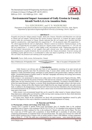
- 10. Environmental Impact Assessment Of… www.theijes.com The IJES Page 53 the highest value and its lowest value on Uruegbe. The result suggests that the soil in Umuazu was more penetrable and less penetrable in Uruegbe soil. viii. Table 14 shows the monthly rainfall data for Anambra state where the study area is located within, rainfall erosivity value calculated for the study area was checked with the Rainfall Aggresivity Index (RAI) in table 15, developed by Fournier, (1960) and modified by Arnoldus, (1980). The result shows that the study area lies in a region of high rainfall aggressivity. V. Conclusion and Recommendation From the results of this work, the following conclusions are reached about the environmental impact of gullies in Umuoji: i. From the results obtained in Atterberg, sieve and compaction test, it shows that the soils in the study area (Umuoji) have low plasticity, and not-compact. Umuoji can be said to have an unfair share of gully erosion. ii. From the results obtained in engineering properties associated with Umuoji soil, it shows that the soils in the study area are cohesive, moderately penetrable, and have less ability to resist shear deformation stresses. This study on the Environmental impact assessment of gully erosion in Umuoji has provided insights into the probable factors of widespread and persistent occurrence of gullies in Umuoji area e.g. fig 1 and 2 below. Concrete terracing of gully affected areas and agroforestry practices that will protect the soil and reduce run-off are recommended. This will also reduce the formation and widening of the incipient gullies. References [1] Burmister .F. (1997) ADVANCED SOIL MECHANICS 2nd edition 471pp. [2] Cavey .B. (2006), Gully erosion, Department of Natural Resources and Water Fact sheets L81 P 1-4. [3] Clayton and Juckles (1978) Standard range of plastic limits of soils. [4] Egboka, B.C.E (1993), Gully erosion in the Agulu-Nanka region of Anambra state, Nigeria. Proceeding of the Harare symposium. IAHS publications. [5] Fullen M.A, and Catt J.A (2004). SOIL MANAGEMENT: Problems and Solutions. London: Arnold. [6] Hunt .N and Glikes .R (1992) FARMMONITORING HANDBOOK. The University of Western Australia: Nedlands, WA [7] Madubuike, C.N, and Chukwuma, G.O (2006). Journal on A USLE soil erodibility factor model for Abia, Ebonyi and Imo states of Nigeria. [8] Nyakatawa, E.Z.; Reddy, K.C.; and Lemunyon, J.L. 2001. Predicting soil erosion in conservation tillage cotton production systems using the revised universal soil loss equation (RUSLE). [9] Onwuka S.U (2008) “Urban erosion problems in Nigeria” Okoye C.O. Onwuka S.U.(Eds), Urban Environmental problems in Nigeria. Fig 1:A picture of gully at Uruegbe in Umuoji Fig 2: A gully at Uruegbe with a water pipeline destroyed