Leveraging Geographic Data in SugarCRM
•Download as KEY, PDF•
1 like•2,562 views

Presentation given at SugarCON 2010.

Recommended
Recommended
More Related Content
What's hot
What's hot (20)
Similar to Leveraging Geographic Data in SugarCRM
Similar to Leveraging Geographic Data in SugarCRM (20)
Recently uploaded
Recently uploaded (20)
Leveraging Geographic Data in SugarCRM
- 1. Leveraging Geographic Data in SugarCRM
- 2. About the Speaker Asa Kusuma • Intern at Milsoft Utility Solutions • Sophomore at Abilene Christian University • Twitter: asakusuma • www.asakusuma.com
- 3. Geographic Data: What’s the Big Deal?
- 4. photo by gerlos Know Your Customers
- 5. Reaching the End Goal New New CRM Create Data Capabilities Visuals Old Filter Insight into Data Data Customer Base
- 6. The End Goal Expanded photo by eBeam • Target customers • Streamline analysis • Get the “Big Picture” • Look good in meetings • Capitalize on data
- 7. photo by eBeam Concept is simple
- 8. photo by Dizzy Girl Implementation is Messy
- 10. About Milsoft • We make software for utility companies • Headquarters in Abilene, TX • Over 1,000 customers, US + International photo by philipbouchard
- 11. Our needs at Milsoft • Send geographic-sensitive data to customers • Marketing • Workshops • Inform decision makers • Streamline meetings • Do it all in SugarCRM
- 12. Bad
- 13. Good
- 14. The Old Way 1. Export SugarCRM data 2. Cleanup data 3. Import data into 3rd party software 4. Filter data or generate visual 5. Cross fingers 6. Import data back into SugarCRM
- 15. The New Way 1. Filter data or create visual in SugarCRM 2. Laugh at people doing it the old way
- 16. Steps to Success 1. Extend your data • Add coordinates to Accounts 2. Create data filtering capabilities • Add geographic filters for Reports 3. Create visuals • Link your Accounts with Google Maps • Link your Reports with Google Maps
- 18. SIMPLICITY
- 19. Blend In
- 20. Guidelines • Permanent, scalable solutions, not hacks • If it’s not simple, it won’t be used • Insert new features into existing workflow • Complement and extend existing features
- 22. Step 1: Add Geographic Data • Get a Google Maps API Key • Create custom fields • Create script • Connect to database • Add coordinates to each account • Run script (takes a long time)
- 23. Create Custom Fields Admin > Studio > Accounts > Fields > Add Field • Add fields to store latitude & longitude • Datatype: Decimal • Uncheck “Required Field” • Check “Reportable” • Populate fields using address + Google Maps
- 25. Create Script • Connect to SugarCRM database • Invoke config.php (don’t hardcode) • Retrieve and loop through Accounts • Send address to Google Maps • Receive Latitude and Longitude • Record coordinates
- 27. Now What? • Accounts with an address have coordinates • Do stuff with the coordinates • Filter Accounts with Reports • Put your Accounts on a map • Put your filtered Accounts on a map
- 28. Filtering in Reports • Select Accounts within a certain distance of a postal code • Add functionality to Reports
- 29. Code the Filter 1. Create the label string 2. Associate the label string with a function 3. Create the function 4. Add the extra text inputs 5. Force a JOIN with accounts_cstm
- 30. Create the String Label modules/Reports/language/en_us.lang.php
- 31. Associate Label with Function modules/Reports/templates/ templates_modules_defs_js.php
- 32. Create the Function Get postal code coordinates Filter query include/generic/SugarWidgets/SugarWidgetReportField.php (queryFilterWithin_Radius())
- 33. Add Extra Text Inputs Add inputs include/javascript/reports.js
- 34. Add Extra Text Inputs (cont.) 2 new arguments Set default input size Add label include/javascript/reports.js (addFilterInputText())
- 35. Force the JOIN Link to accounts_cstm • Custom fields are stored in accounts_cstm • JOIN combines accounts and accounts_cstm modules/Reports/Reports.php (create_from())
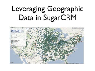
- 36. Radius Distance Radius Center (Postal Code) The Result
- 37. Make a Simple Map
- 38. Code the Map 1. Connect to the database 2. Pull Account coordinates 3. Pass data from PHP to JavaScript 4. Plot points on the Google Map
- 39. Setup the Map Connect to database Import jQuery and Google Map stuff map.php (in the root directory)
- 40. Display the Map Echo out data as a JavaScript array Plot points on the map map.php (in the root directory)
- 41. The Result
- 42. nifty link Put it all together
- 43. Data Path Report ID Report Map Report Data ID Points Query Database
- 44. Create Query Retrieval Function Check for Lat & Long columns Add Lat & Long columns Build Query Return Query modules/Reports/Reports.php (execute_query())
- 45. Link From Report to Map Create link modules/Reports/Reports.php (execute_query())
- 46. Prepare the Data for the Map Receive Report ID Create a Report Produce MySQL query modules/Reports/map.php
- 47. Display the Map Package account as a point Initialize Map Plot data on Map modules/Reports/map.php
- 48. click here... Put it all together
- 49. The Final Result
- 50. Try This At Home • Protect your data • Work out the kinks • Issues with editing Reports • Issues with multi-module Reports • Code Snippets at: http://www.asakusuma.com/sugarcon • Be the envy of your next meeting
- 51. photo by gerlos Know Your Customers
Editor's Notes
- milsoft computer science major open source web development and clean web design
- If it’s not simple, users won’t use