SlideShare a Scribd company logo
1 of 26
Location and Time
Latitude and LongitudeLatitude and Longitude
The latitude and longitude system wasThe latitude and longitude system was
developed in the middle ages. Ptolemydeveloped in the middle ages. Ptolemy
also used a grid system in ancient Greece.also used a grid system in ancient Greece.
Latitude lines run horizontallyLatitude lines run horizontally
and are also known asand are also known as
parallels.parallels.
Longitude lines, also knownLongitude lines, also known
as meridians, run vertically.as meridians, run vertically.
a) Latitude (Parallels) b) Longitude (Meridians)
The Geographic Grid
Latitude
1. Latitude lines are also known as
parallels because they are parallel and
are an equal distance apart from each
other.
2. Each degree of latitude is
approximately 69 miles apart. There is
a slight variation because the earth is
not round, but more ellipsoid.
3. One way to remember latitude is to
imagine it as the rungs of a ladder,
“ladder-tude.”
4. Degrees of latitude are numbered from
0 to 90, both north and south.
5. 0° is the Equator, the imaginary line that
divides the earth into northern and
southern hemispheres.
6. 90° north is the North Pole and 90°
south is the South Pole.
The Equator: 0° N/SThe Equator: 0° N/S
Longitude
1. Longitude lines are also known
as meridians.
2. They are about 69 miles apart at
the equator, they converge at the
poles.
3. 0° longitude is located at
Greenwich, England.
4. The degrees continue to 180°
east and west until they meet at
the International Date Line in the
Pacific Ocean.
Prime Meridian: 0° E/WPrime Meridian: 0° E/W
► Greenwich, England: the site of theGreenwich, England: the site of the
British Royal Greenwich Observatory,British Royal Greenwich Observatory,
was established as the site of thewas established as the site of the
Prime Meridian by an internationalPrime Meridian by an international
conference in 1884.conference in 1884.
International Date Line 180° E/WInternational Date Line 180° E/W
Longitude and LatitudeLongitude and Latitude
• Degrees longitude and latitude are divided
into minutes (') and seconds (").
– There are 60 minutes in each degree.
• Each minute is divided into 60 seconds.
– Seconds can be further divided into tenths, hundredths,
or even thousandths.
• For example, the U.S. Capitol is located at
38°53'23"N , 77°00'27"W
– Or 38°, 53 minutes, and 23 seconds north of
the equator and 77 degrees, no minutes and
27 seconds west of the meridian passing
through Greenwich, England).
Longitude and LatitudeLongitude and Latitude
How to write Latitude and
Longitude
• Coordinates of latitude and longitude
are ALWAYS written as
LATITUDE 1st
, LONGITUDE 2nd
N or S°, E or W°
• For Example- Victorville, CA:
34° N, 118° W
• Directions MUST always be included
in the coordinates
• AAA is located at the corner
of Haven Ave. and Foothill Bl.
Using Latitude and
Longitude
Latitude and longitude are like imaginary streets on the earth.
1. Go to your starting line (the Equator).
2. Determine which direction you must go (north or south).
3. Determine the distance in degrees you must go.
*This will give you the location of one of your streets*
1. Go to your starting line (the Prime Meridian).
2. Determine which direction you must go (east or west).
3. Determine the distance in degrees you must go.
*This will give the location of your second street.*
If you find the imaginary intersection of the two roads, then you have found the exact
location of a particular place!
Using your atlasUsing your atlas
• An atlas is a collection of maps compiled into an easy-to-
use format
• It usually has an accompanying index, which is an
alphabetical listing of place names and their
pronunciations
• Atlases may be general in nature and cover the entire
globe, or they may be specific to geographical locations,
topics or time periods
– Specialized atlases exist in a wide variety of topics
– Most libraries have atlases in their reference sections.
Goode’s World AtlasGoode’s World Atlas
• Introduction
– Contains information about:
• The edition of the Atlas you are using
• Basic Earth properties
– Information on longitude and latitude, important grid lines, and more
• Map Scale
• Map Projections
• Thematic Maps
– Information about the different types of maps included in the atlas
• Map Legend
– This section is very important!
– Contains information about the symbols used on the maps
• For example, shows the different sized dots that are used to represent
cities and what the population is for each sized dot
• Also shows the symbols used to depict landforms
• World Maps
• Regional Maps
• Tables and Indexes
Goode’s World AtlasGoode’s World Atlas
• World Maps Section
– This section contains many world maps
including:
• Political, physical, landforms, volcanoes, ocean
floor, climates, vegetation, soil, population density,
gross domestic product, literacy, languages,
minerals, nuclear power, military power,
telecommunications, and more.
Goode’s World AtlasGoode’s World Atlas
• Regional Maps Section
– This is separated into regions with many different
maps of each region.
– The regions in this atlas are:
1. North America
2. South America
3. Europe
4. Asia
5. Australia, Oceania, and Antarctica
6. Africa
7. Oceans and Arctic Region
Goode’s World AtlasGoode’s World Atlas
• Tables and Indexes Section
– This section contains an alphabetical list of all of the
places in the atlas, which includes a pronunciation
guide, page number where the place can be found in
the atlas, and the latitude and longitude coordinates.
– It also contains:
• A glossary of foreign geographic terms
• General Information about:
– Land area of islands, area of lakes and oceans, heights of
mountains, length of rivers, population for large cities
• World Political Information
• World Demographic Information
• World Agriculture Information
• World Economic Tables
Time
Time
• Early agricultural societies found that local noon could be
determined by observing the changing length of the shadow cast
by a stick placed perpendicular to the ground. Local noon is the
time at which the shadow is the shortest length cast. Romans used
this principle to design their sundials and called their noon position
of the Sun the "meridian" (meridiem - the Sun's highest point of the
day).
• It was difficult to compare time as one traveled to different localities
as each city adjusted its clocks to their own local noon.
• Because the Earth rotates toward the east, towns to the east
experienced solar noon earlier while those to the west later.
Standard Time
• As cross-country travel and communication became faster and more
efficient, a standardized system of global time was required.
• Given the Earth rotates once throughout a 24 hour period, 24 standard times
zones were agreed upon at the 1884 International Prime Meridian
Conference.
• The local solar time at Greenwich, England was designated the prime
meridian. Each time zone extends 7.5° on either side of a central meridian.
• For years the global standard for reporting time was Greenwich mean time
(GMT). GMT is now referred to as Universal Time Coordinated (UTC) but
the prime meridian is still the reference for standard time.
International Date
LineFerdinand Magellan and crew in 1519 set
out on their westward journey from Spain
to circumnavigate the Earth. Upon their
return three years later, they discovered
that
their meticulously kept logs were off by one
day. This was one of the first recorded
experience with changing global time. This
earlier experience would ultimately lead to
the establishment of the international date
line. The International Date Line lies
directly opposite of the prime meridian and
having a longitude of 180°. Crossing the
line when traveling east one turns their
calendar back a full day. Traveling west one
moves their calendar forward one day.
Daylight Saving TimeDaylight Saving Time
 Many countries observeMany countries observe
daylight saving timedaylight saving time - the- the
practice of setting clockspractice of setting clocks
forward one hour in the springforward one hour in the spring
and back one hour in the fall.and back one hour in the fall.
 First proposed by BenjaminFirst proposed by Benjamin
Franklin, the notion ofFranklin, the notion of
extending daylight one hourextending daylight one hour
into the evening didn't catchinto the evening didn't catch
hold until World War One as ahold until World War One as a
means of energy savings.means of energy savings.
 Some countries, territories,Some countries, territories,
and states in the U.S. do notand states in the U.S. do not
observe daylight saving time.observe daylight saving time.
Standard MeridiansStandard Meridians
• There are 24 standard
meridians.
• They are all 15° apart.
• The first standard meridian is
the Prime Meridian.
• Time does NOT change at the
standard meridians.
– The standard meridian is the
middle of the time zone.
– Time zones extend 7.5° on
each side of the standard
meridian.
US Time Zones
Assignment
• Read Section Three: Location
– Complete Problems-Part I 1 a-e, 2 a-e,
Problems-Part II 1 a-e, 2 a-d, 3, and 4
• Read Section Four: Time
– Complete Problems-Part I 1-4, Problems-Part
II 1 a & b, 2, and 3
– Complete worksheet “Calculating Time” 1 a-d,
2, 3 a-e

More Related Content

What's hot

UNDERSTANDING TIME & DATE MERIDIAN
UNDERSTANDING TIME & DATE MERIDIANUNDERSTANDING TIME & DATE MERIDIAN
UNDERSTANDING TIME & DATE MERIDIANHimadri Samal
 
Time zones and international date line (idl
Time zones and international date line (idlTime zones and international date line (idl
Time zones and international date line (idlMuhammad Sajjad
 
Time Presentation
Time Presentation Time Presentation
Time Presentation Vj NiroSh
 
8.Charts
8.Charts8.Charts
8.ChartsAmenBAL
 
Field astronomy in surveying
Field astronomy in surveyingField astronomy in surveying
Field astronomy in surveyingsuraj jha
 
Field astronomy and triangulation
Field astronomy and triangulationField astronomy and triangulation
Field astronomy and triangulationPankaj Kushwaha
 
Celestial coordinate systems
Celestial coordinate systemsCelestial coordinate systems
Celestial coordinate systemsSalah Mahmood
 
Surveying geodesy ajith sir
Surveying   geodesy ajith sirSurveying   geodesy ajith sir
Surveying geodesy ajith sirSHAMJITH KM
 
Intro to basic navigation lrg
Intro to basic navigation lrgIntro to basic navigation lrg
Intro to basic navigation lrgLance Grindley
 
Field astronomy - Advanced surveying
Field astronomy - Advanced surveying Field astronomy - Advanced surveying
Field astronomy - Advanced surveying Vijay Parmar
 
FIELD ASTRONOMY SURVEYING
FIELD ASTRONOMY SURVEYINGFIELD ASTRONOMY SURVEYING
FIELD ASTRONOMY SURVEYINGKavin Raval
 
Field Astronomy -Astronomical terms & Co-ordinate system
Field Astronomy -Astronomical terms & Co-ordinate systemField Astronomy -Astronomical terms & Co-ordinate system
Field Astronomy -Astronomical terms & Co-ordinate systemBathla Tuition Centre
 
Latitudes and longitudes
Latitudes and longitudesLatitudes and longitudes
Latitudes and longitudesthemassmaker
 
Geospatial reference-systems
Geospatial reference-systemsGeospatial reference-systems
Geospatial reference-systemsStephen
 
6th std Social Science- Geography ch- 2 Latitudes and Longitudes
6th std Social Science- Geography   ch- 2 Latitudes and Longitudes6th std Social Science- Geography   ch- 2 Latitudes and Longitudes
6th std Social Science- Geography ch- 2 Latitudes and LongitudesNavya Rai
 

What's hot (20)

9. Time
9. Time9. Time
9. Time
 
UNDERSTANDING TIME & DATE MERIDIAN
UNDERSTANDING TIME & DATE MERIDIANUNDERSTANDING TIME & DATE MERIDIAN
UNDERSTANDING TIME & DATE MERIDIAN
 
Time zones and international date line (idl
Time zones and international date line (idlTime zones and international date line (idl
Time zones and international date line (idl
 
Time Presentation
Time Presentation Time Presentation
Time Presentation
 
8.Charts
8.Charts8.Charts
8.Charts
 
Field astronomy in surveying
Field astronomy in surveyingField astronomy in surveying
Field astronomy in surveying
 
Field astronomy and triangulation
Field astronomy and triangulationField astronomy and triangulation
Field astronomy and triangulation
 
Ncert earth
Ncert earthNcert earth
Ncert earth
 
Field.astronomy
Field.astronomyField.astronomy
Field.astronomy
 
Celestial coordinate systems
Celestial coordinate systemsCelestial coordinate systems
Celestial coordinate systems
 
Surveying geodesy ajith sir
Surveying   geodesy ajith sirSurveying   geodesy ajith sir
Surveying geodesy ajith sir
 
navigation
navigationnavigation
navigation
 
Intro to basic navigation lrg
Intro to basic navigation lrgIntro to basic navigation lrg
Intro to basic navigation lrg
 
Field astronomy - Advanced surveying
Field astronomy - Advanced surveying Field astronomy - Advanced surveying
Field astronomy - Advanced surveying
 
FIELD ASTRONOMY SURVEYING
FIELD ASTRONOMY SURVEYINGFIELD ASTRONOMY SURVEYING
FIELD ASTRONOMY SURVEYING
 
Field Astronomy -Astronomical terms & Co-ordinate system
Field Astronomy -Astronomical terms & Co-ordinate systemField Astronomy -Astronomical terms & Co-ordinate system
Field Astronomy -Astronomical terms & Co-ordinate system
 
Latitudes and longitudes
Latitudes and longitudesLatitudes and longitudes
Latitudes and longitudes
 
Intro to Navigation
Intro to NavigationIntro to Navigation
Intro to Navigation
 
Geospatial reference-systems
Geospatial reference-systemsGeospatial reference-systems
Geospatial reference-systems
 
6th std Social Science- Geography ch- 2 Latitudes and Longitudes
6th std Social Science- Geography   ch- 2 Latitudes and Longitudes6th std Social Science- Geography   ch- 2 Latitudes and Longitudes
6th std Social Science- Geography ch- 2 Latitudes and Longitudes
 

Viewers also liked

Summer 2016 geog 110 schmidt
Summer 2016 geog 110 schmidtSummer 2016 geog 110 schmidt
Summer 2016 geog 110 schmidtLisa Schmidt
 
C:\Fakepath\Earth’S Grid
C:\Fakepath\Earth’S GridC:\Fakepath\Earth’S Grid
C:\Fakepath\Earth’S Gridguestdf739ebb
 
FOSTEr in MED Pilot project Conference in Cagliari 28/06/2016: pilots present...
FOSTEr in MED Pilot project Conference in Cagliari 28/06/2016: pilots present...FOSTEr in MED Pilot project Conference in Cagliari 28/06/2016: pilots present...
FOSTEr in MED Pilot project Conference in Cagliari 28/06/2016: pilots present...FOSTEr in MED
 
Lab five us geological survey topographic maps & us public
Lab five us geological survey topographic maps & us publicLab five us geological survey topographic maps & us public
Lab five us geological survey topographic maps & us publiclschmidt1170
 
Lab five us geological survey topographic maps & us public
Lab five us geological survey topographic maps & us publicLab five us geological survey topographic maps & us public
Lab five us geological survey topographic maps & us publicLisa Schmidt
 
Lab four isolines and contour lines
Lab four isolines and contour linesLab four isolines and contour lines
Lab four isolines and contour lineslschmidt1170
 
Space_Cycles_review
Space_Cycles_reviewSpace_Cycles_review
Space_Cycles_reviewDavidSP1996
 
Reasons for the seasons notes
Reasons for the seasons notesReasons for the seasons notes
Reasons for the seasons notesmrcoyleteach
 
Tides, Neap Tide, Spring Tide, Astronomy Lesson PowerPoint
Tides, Neap Tide, Spring Tide, Astronomy Lesson PowerPointTides, Neap Tide, Spring Tide, Astronomy Lesson PowerPoint
Tides, Neap Tide, Spring Tide, Astronomy Lesson PowerPointwww.sciencepowerpoint.com
 
Seasons, Earth, Axial Tilt Lesson PowerPoint
Seasons, Earth, Axial Tilt Lesson PowerPointSeasons, Earth, Axial Tilt Lesson PowerPoint
Seasons, Earth, Axial Tilt Lesson PowerPointwww.sciencepowerpoint.com
 
Eclipses And Tides
Eclipses And TidesEclipses And Tides
Eclipses And Tidesshas595
 
Rotation and revolution powerpoint
Rotation and revolution powerpointRotation and revolution powerpoint
Rotation and revolution powerpointJaydian Thompson
 
The movements of the Earth
The movements of the Earth  The movements of the Earth
The movements of the Earth Mariadebiologia
 

Viewers also liked (20)

Summer 2016 geog 110 schmidt
Summer 2016 geog 110 schmidtSummer 2016 geog 110 schmidt
Summer 2016 geog 110 schmidt
 
Solstice and equinox
Solstice and equinoxSolstice and equinox
Solstice and equinox
 
C:\Fakepath\Earth’S Grid
C:\Fakepath\Earth’S GridC:\Fakepath\Earth’S Grid
C:\Fakepath\Earth’S Grid
 
FOSTEr in MED Pilot project Conference in Cagliari 28/06/2016: pilots present...
FOSTEr in MED Pilot project Conference in Cagliari 28/06/2016: pilots present...FOSTEr in MED Pilot project Conference in Cagliari 28/06/2016: pilots present...
FOSTEr in MED Pilot project Conference in Cagliari 28/06/2016: pilots present...
 
Earth’S Grid
Earth’S GridEarth’S Grid
Earth’S Grid
 
Lab five us geological survey topographic maps & us public
Lab five us geological survey topographic maps & us publicLab five us geological survey topographic maps & us public
Lab five us geological survey topographic maps & us public
 
Lab five us geological survey topographic maps & us public
Lab five us geological survey topographic maps & us publicLab five us geological survey topographic maps & us public
Lab five us geological survey topographic maps & us public
 
Lab four isolines and contour lines
Lab four isolines and contour linesLab four isolines and contour lines
Lab four isolines and contour lines
 
Start with the Golden Circle - How Great Leaders Inspire Action
Start with the Golden Circle - How Great Leaders Inspire ActionStart with the Golden Circle - How Great Leaders Inspire Action
Start with the Golden Circle - How Great Leaders Inspire Action
 
Chap 3 locating places
Chap 3  locating placesChap 3  locating places
Chap 3 locating places
 
Space_Cycles_review
Space_Cycles_reviewSpace_Cycles_review
Space_Cycles_review
 
Reasons for the seasons notes
Reasons for the seasons notesReasons for the seasons notes
Reasons for the seasons notes
 
spherical triangles
spherical trianglesspherical triangles
spherical triangles
 
Tides, Neap Tide, Spring Tide, Astronomy Lesson PowerPoint
Tides, Neap Tide, Spring Tide, Astronomy Lesson PowerPointTides, Neap Tide, Spring Tide, Astronomy Lesson PowerPoint
Tides, Neap Tide, Spring Tide, Astronomy Lesson PowerPoint
 
Four Seasons
Four SeasonsFour Seasons
Four Seasons
 
Seasons, Earth, Axial Tilt Lesson PowerPoint
Seasons, Earth, Axial Tilt Lesson PowerPointSeasons, Earth, Axial Tilt Lesson PowerPoint
Seasons, Earth, Axial Tilt Lesson PowerPoint
 
Eclipses And Tides
Eclipses And TidesEclipses And Tides
Eclipses And Tides
 
Tides notes ppt
Tides notes pptTides notes ppt
Tides notes ppt
 
Rotation and revolution powerpoint
Rotation and revolution powerpointRotation and revolution powerpoint
Rotation and revolution powerpoint
 
The movements of the Earth
The movements of the Earth  The movements of the Earth
The movements of the Earth
 

Similar to Lab two location and time

Geographic Coordinate System.pdf
Geographic Coordinate System.pdfGeographic Coordinate System.pdf
Geographic Coordinate System.pdfTrippinsunshine
 
Geography five lab one
Geography five lab oneGeography five lab one
Geography five lab onelschmidt1170
 
The Globe And It's Features
The Globe And It's FeaturesThe Globe And It's Features
The Globe And It's FeaturesRonel Ragmat
 
FINAL globe latitudes and longitudes (1).pptx
FINAL globe  latitudes and longitudes (1).pptxFINAL globe  latitudes and longitudes (1).pptx
FINAL globe latitudes and longitudes (1).pptxChhayaRajeev
 
Types of maps, long, lat, satellites, time zones
Types of maps, long, lat, satellites, time zonesTypes of maps, long, lat, satellites, time zones
Types of maps, long, lat, satellites, time zonesBantay's Earth Science!
 
Travel Agency and Tour Operation Management -Geography of Tourism
Travel Agency and Tour Operation Management -Geography of TourismTravel Agency and Tour Operation Management -Geography of Tourism
Travel Agency and Tour Operation Management -Geography of TourismNataraja T.C
 
lat_and_lon_poewrpoint1_teacher_copy.ppt
lat_and_lon_poewrpoint1_teacher_copy.pptlat_and_lon_poewrpoint1_teacher_copy.ppt
lat_and_lon_poewrpoint1_teacher_copy.pptASShyamkumar4792
 
Geography five lab one
Geography five lab oneGeography five lab one
Geography five lab onelschmidt1170
 
Geographic grid latitudes and longitudes made by Ravi Bharti
Geographic grid  latitudes and longitudes made by Ravi BhartiGeographic grid  latitudes and longitudes made by Ravi Bharti
Geographic grid latitudes and longitudes made by Ravi BhartiRaviBharti18
 
Geographical Themes and Terms
Geographical Themes and TermsGeographical Themes and Terms
Geographical Themes and Termsafrancksjrcs
 
globe latitudes and longitudes.pptx
globe  latitudes and longitudes.pptxglobe  latitudes and longitudes.pptx
globe latitudes and longitudes.pptxChhayaRajeev
 
training course on navigation of a ship.pptx
training course on navigation of a ship.pptxtraining course on navigation of a ship.pptx
training course on navigation of a ship.pptxdevmarineacademy
 
The earth - Our Living Planet
The earth - Our Living PlanetThe earth - Our Living Planet
The earth - Our Living PlanetSuzzy Sandy
 
Longitude and latitude gr 10.pptx
Longitude and latitude gr 10.pptxLongitude and latitude gr 10.pptx
Longitude and latitude gr 10.pptxlyba643
 

Similar to Lab two location and time (20)

Geographic Coordinate System.pdf
Geographic Coordinate System.pdfGeographic Coordinate System.pdf
Geographic Coordinate System.pdf
 
Geography five lab one
Geography five lab oneGeography five lab one
Geography five lab one
 
The Globe And It's Features
The Globe And It's FeaturesThe Globe And It's Features
The Globe And It's Features
 
FINAL globe latitudes and longitudes (1).pptx
FINAL globe  latitudes and longitudes (1).pptxFINAL globe  latitudes and longitudes (1).pptx
FINAL globe latitudes and longitudes (1).pptx
 
Types of maps, long, lat, satellites, time zones
Types of maps, long, lat, satellites, time zonesTypes of maps, long, lat, satellites, time zones
Types of maps, long, lat, satellites, time zones
 
Travel Agency and Tour Operation Management -Geography of Tourism
Travel Agency and Tour Operation Management -Geography of TourismTravel Agency and Tour Operation Management -Geography of Tourism
Travel Agency and Tour Operation Management -Geography of Tourism
 
lat_and_lon_poewrpoint1_teacher_copy.ppt
lat_and_lon_poewrpoint1_teacher_copy.pptlat_and_lon_poewrpoint1_teacher_copy.ppt
lat_and_lon_poewrpoint1_teacher_copy.ppt
 
Geography five lab one
Geography five lab oneGeography five lab one
Geography five lab one
 
Geographic grid latitudes and longitudes made by Ravi Bharti
Geographic grid  latitudes and longitudes made by Ravi BhartiGeographic grid  latitudes and longitudes made by Ravi Bharti
Geographic grid latitudes and longitudes made by Ravi Bharti
 
Geographical Themes and Terms
Geographical Themes and TermsGeographical Themes and Terms
Geographical Themes and Terms
 
lec-gps (2).ppt
lec-gps (2).pptlec-gps (2).ppt
lec-gps (2).ppt
 
Geography 6
Geography 6Geography 6
Geography 6
 
QUICK GEOGRAPHY (1).pdf
QUICK GEOGRAPHY (1).pdfQUICK GEOGRAPHY (1).pdf
QUICK GEOGRAPHY (1).pdf
 
Unit1 160131210057
Unit1 160131210057Unit1 160131210057
Unit1 160131210057
 
globe latitudes and longitudes.pptx
globe  latitudes and longitudes.pptxglobe  latitudes and longitudes.pptx
globe latitudes and longitudes.pptx
 
training course on navigation of a ship.pptx
training course on navigation of a ship.pptxtraining course on navigation of a ship.pptx
training course on navigation of a ship.pptx
 
4 atlas en kaartskale
4 atlas en kaartskale4 atlas en kaartskale
4 atlas en kaartskale
 
The earth - Our Living Planet
The earth - Our Living PlanetThe earth - Our Living Planet
The earth - Our Living Planet
 
earth living planet.pptx
earth living planet.pptxearth living planet.pptx
earth living planet.pptx
 
Longitude and latitude gr 10.pptx
Longitude and latitude gr 10.pptxLongitude and latitude gr 10.pptx
Longitude and latitude gr 10.pptx
 

More from Lisa Schmidt

Chapter 1 A World Of Regions
Chapter 1 A World Of RegionsChapter 1 A World Of Regions
Chapter 1 A World Of RegionsLisa Schmidt
 
The giant ancient forest you cannot see coyote crossing
The giant ancient forest you cannot see   coyote crossingThe giant ancient forest you cannot see   coyote crossing
The giant ancient forest you cannot see coyote crossingLisa Schmidt
 
Summer geog lab 2016 schmidt
Summer geog lab 2016 schmidtSummer geog lab 2016 schmidt
Summer geog lab 2016 schmidtLisa Schmidt
 
Summer geog 101 2016 schmidt
Summer geog 101 2016 schmidtSummer geog 101 2016 schmidt
Summer geog 101 2016 schmidtLisa Schmidt
 
Daylight saving time may have health costs la times
Daylight saving time may have health costs   la timesDaylight saving time may have health costs   la times
Daylight saving time may have health costs la timesLisa Schmidt
 
Daylight saving time could end in california the sacramento bee
Daylight saving time could end in california   the sacramento beeDaylight saving time could end in california   the sacramento bee
Daylight saving time could end in california the sacramento beeLisa Schmidt
 
Ch 3 worksheet edited
Ch 3 worksheet editedCh 3 worksheet edited
Ch 3 worksheet editedLisa Schmidt
 
Intro spring 2016 geog 101 l
Intro spring 2016 geog 101 lIntro spring 2016 geog 101 l
Intro spring 2016 geog 101 lLisa Schmidt
 
Syllabus geography 102 spring 2016
Syllabus geography 102 spring 2016Syllabus geography 102 spring 2016
Syllabus geography 102 spring 2016Lisa Schmidt
 
Could a great quake strike on the enigmatic san jacinto fault temblor
Could a great quake strike on the enigmatic san jacinto fault    temblorCould a great quake strike on the enigmatic san jacinto fault    temblor
Could a great quake strike on the enigmatic san jacinto fault temblorLisa Schmidt
 
Introspringonlinegeog110 14 wk
Introspringonlinegeog110 14 wkIntrospringonlinegeog110 14 wk
Introspringonlinegeog110 14 wkLisa Schmidt
 
Spring 2016 syllabus geog 110 sect 71
Spring 2016 syllabus geog 110 sect 71Spring 2016 syllabus geog 110 sect 71
Spring 2016 syllabus geog 110 sect 71Lisa Schmidt
 
Spring geog 101 mon 2016 schmid
Spring geog 101 mon 2016 schmidSpring geog 101 mon 2016 schmid
Spring geog 101 mon 2016 schmidLisa Schmidt
 
Geog lab syllabus wed spring 2016
Geog lab syllabus wed spring 2016Geog lab syllabus wed spring 2016
Geog lab syllabus wed spring 2016Lisa Schmidt
 
Will exxon have to pay for years of misleading the public bill moyers
Will exxon have to pay for years of misleading the public    bill moyersWill exxon have to pay for years of misleading the public    bill moyers
Will exxon have to pay for years of misleading the public bill moyersLisa Schmidt
 
Periodic table's 7th row completed with discovery of four new elements ifl ...
Periodic table's 7th row completed with discovery of four new elements   ifl ...Periodic table's 7th row completed with discovery of four new elements   ifl ...
Periodic table's 7th row completed with discovery of four new elements ifl ...Lisa Schmidt
 
Intro geog 120 spr 2016 sbvc
Intro geog 120 spr 2016 sbvcIntro geog 120 spr 2016 sbvc
Intro geog 120 spr 2016 sbvcLisa Schmidt
 

More from Lisa Schmidt (20)

Chapter 1 A World Of Regions
Chapter 1 A World Of RegionsChapter 1 A World Of Regions
Chapter 1 A World Of Regions
 
Eastern europe
Eastern europeEastern europe
Eastern europe
 
The giant ancient forest you cannot see coyote crossing
The giant ancient forest you cannot see   coyote crossingThe giant ancient forest you cannot see   coyote crossing
The giant ancient forest you cannot see coyote crossing
 
Summer geog lab 2016 schmidt
Summer geog lab 2016 schmidtSummer geog lab 2016 schmidt
Summer geog lab 2016 schmidt
 
Summer geog 101 2016 schmidt
Summer geog 101 2016 schmidtSummer geog 101 2016 schmidt
Summer geog 101 2016 schmidt
 
Daylight saving time may have health costs la times
Daylight saving time may have health costs   la timesDaylight saving time may have health costs   la times
Daylight saving time may have health costs la times
 
Daylight saving time could end in california the sacramento bee
Daylight saving time could end in california   the sacramento beeDaylight saving time could end in california   the sacramento bee
Daylight saving time could end in california the sacramento bee
 
Ch 3 worksheet edited
Ch 3 worksheet editedCh 3 worksheet edited
Ch 3 worksheet edited
 
Intro spring 2016
Intro spring 2016Intro spring 2016
Intro spring 2016
 
Intro spring 2016 geog 101 l
Intro spring 2016 geog 101 lIntro spring 2016 geog 101 l
Intro spring 2016 geog 101 l
 
Syllabus geography 102 spring 2016
Syllabus geography 102 spring 2016Syllabus geography 102 spring 2016
Syllabus geography 102 spring 2016
 
Could a great quake strike on the enigmatic san jacinto fault temblor
Could a great quake strike on the enigmatic san jacinto fault    temblorCould a great quake strike on the enigmatic san jacinto fault    temblor
Could a great quake strike on the enigmatic san jacinto fault temblor
 
Introspringonlinegeog110 14 wk
Introspringonlinegeog110 14 wkIntrospringonlinegeog110 14 wk
Introspringonlinegeog110 14 wk
 
Spring 2016 syllabus geog 110 sect 71
Spring 2016 syllabus geog 110 sect 71Spring 2016 syllabus geog 110 sect 71
Spring 2016 syllabus geog 110 sect 71
 
Spring geog 101 mon 2016 schmid
Spring geog 101 mon 2016 schmidSpring geog 101 mon 2016 schmid
Spring geog 101 mon 2016 schmid
 
Geog lab syllabus wed spring 2016
Geog lab syllabus wed spring 2016Geog lab syllabus wed spring 2016
Geog lab syllabus wed spring 2016
 
Will exxon have to pay for years of misleading the public bill moyers
Will exxon have to pay for years of misleading the public    bill moyersWill exxon have to pay for years of misleading the public    bill moyers
Will exxon have to pay for years of misleading the public bill moyers
 
Periodic table's 7th row completed with discovery of four new elements ifl ...
Periodic table's 7th row completed with discovery of four new elements   ifl ...Periodic table's 7th row completed with discovery of four new elements   ifl ...
Periodic table's 7th row completed with discovery of four new elements ifl ...
 
Geography basics
Geography basicsGeography basics
Geography basics
 
Intro geog 120 spr 2016 sbvc
Intro geog 120 spr 2016 sbvcIntro geog 120 spr 2016 sbvc
Intro geog 120 spr 2016 sbvc
 

Lab two location and time

  • 2. Latitude and LongitudeLatitude and Longitude The latitude and longitude system wasThe latitude and longitude system was developed in the middle ages. Ptolemydeveloped in the middle ages. Ptolemy also used a grid system in ancient Greece.also used a grid system in ancient Greece. Latitude lines run horizontallyLatitude lines run horizontally and are also known asand are also known as parallels.parallels. Longitude lines, also knownLongitude lines, also known as meridians, run vertically.as meridians, run vertically.
  • 3. a) Latitude (Parallels) b) Longitude (Meridians) The Geographic Grid
  • 4. Latitude 1. Latitude lines are also known as parallels because they are parallel and are an equal distance apart from each other. 2. Each degree of latitude is approximately 69 miles apart. There is a slight variation because the earth is not round, but more ellipsoid. 3. One way to remember latitude is to imagine it as the rungs of a ladder, “ladder-tude.” 4. Degrees of latitude are numbered from 0 to 90, both north and south. 5. 0° is the Equator, the imaginary line that divides the earth into northern and southern hemispheres. 6. 90° north is the North Pole and 90° south is the South Pole.
  • 5. The Equator: 0° N/SThe Equator: 0° N/S
  • 6. Longitude 1. Longitude lines are also known as meridians. 2. They are about 69 miles apart at the equator, they converge at the poles. 3. 0° longitude is located at Greenwich, England. 4. The degrees continue to 180° east and west until they meet at the International Date Line in the Pacific Ocean.
  • 7. Prime Meridian: 0° E/WPrime Meridian: 0° E/W ► Greenwich, England: the site of theGreenwich, England: the site of the British Royal Greenwich Observatory,British Royal Greenwich Observatory, was established as the site of thewas established as the site of the Prime Meridian by an internationalPrime Meridian by an international conference in 1884.conference in 1884.
  • 8. International Date Line 180° E/WInternational Date Line 180° E/W
  • 9. Longitude and LatitudeLongitude and Latitude • Degrees longitude and latitude are divided into minutes (') and seconds ("). – There are 60 minutes in each degree. • Each minute is divided into 60 seconds. – Seconds can be further divided into tenths, hundredths, or even thousandths.
  • 10. • For example, the U.S. Capitol is located at 38°53'23"N , 77°00'27"W – Or 38°, 53 minutes, and 23 seconds north of the equator and 77 degrees, no minutes and 27 seconds west of the meridian passing through Greenwich, England). Longitude and LatitudeLongitude and Latitude
  • 11. How to write Latitude and Longitude • Coordinates of latitude and longitude are ALWAYS written as LATITUDE 1st , LONGITUDE 2nd N or S°, E or W° • For Example- Victorville, CA: 34° N, 118° W • Directions MUST always be included in the coordinates
  • 12. • AAA is located at the corner of Haven Ave. and Foothill Bl. Using Latitude and Longitude Latitude and longitude are like imaginary streets on the earth. 1. Go to your starting line (the Equator). 2. Determine which direction you must go (north or south). 3. Determine the distance in degrees you must go. *This will give you the location of one of your streets* 1. Go to your starting line (the Prime Meridian). 2. Determine which direction you must go (east or west). 3. Determine the distance in degrees you must go. *This will give the location of your second street.* If you find the imaginary intersection of the two roads, then you have found the exact location of a particular place!
  • 13. Using your atlasUsing your atlas • An atlas is a collection of maps compiled into an easy-to- use format • It usually has an accompanying index, which is an alphabetical listing of place names and their pronunciations • Atlases may be general in nature and cover the entire globe, or they may be specific to geographical locations, topics or time periods – Specialized atlases exist in a wide variety of topics – Most libraries have atlases in their reference sections.
  • 14. Goode’s World AtlasGoode’s World Atlas • Introduction – Contains information about: • The edition of the Atlas you are using • Basic Earth properties – Information on longitude and latitude, important grid lines, and more • Map Scale • Map Projections • Thematic Maps – Information about the different types of maps included in the atlas • Map Legend – This section is very important! – Contains information about the symbols used on the maps • For example, shows the different sized dots that are used to represent cities and what the population is for each sized dot • Also shows the symbols used to depict landforms • World Maps • Regional Maps • Tables and Indexes
  • 15. Goode’s World AtlasGoode’s World Atlas • World Maps Section – This section contains many world maps including: • Political, physical, landforms, volcanoes, ocean floor, climates, vegetation, soil, population density, gross domestic product, literacy, languages, minerals, nuclear power, military power, telecommunications, and more.
  • 16. Goode’s World AtlasGoode’s World Atlas • Regional Maps Section – This is separated into regions with many different maps of each region. – The regions in this atlas are: 1. North America 2. South America 3. Europe 4. Asia 5. Australia, Oceania, and Antarctica 6. Africa 7. Oceans and Arctic Region
  • 17. Goode’s World AtlasGoode’s World Atlas • Tables and Indexes Section – This section contains an alphabetical list of all of the places in the atlas, which includes a pronunciation guide, page number where the place can be found in the atlas, and the latitude and longitude coordinates. – It also contains: • A glossary of foreign geographic terms • General Information about: – Land area of islands, area of lakes and oceans, heights of mountains, length of rivers, population for large cities • World Political Information • World Demographic Information • World Agriculture Information • World Economic Tables
  • 18. Time
  • 19. Time • Early agricultural societies found that local noon could be determined by observing the changing length of the shadow cast by a stick placed perpendicular to the ground. Local noon is the time at which the shadow is the shortest length cast. Romans used this principle to design their sundials and called their noon position of the Sun the "meridian" (meridiem - the Sun's highest point of the day). • It was difficult to compare time as one traveled to different localities as each city adjusted its clocks to their own local noon. • Because the Earth rotates toward the east, towns to the east experienced solar noon earlier while those to the west later.
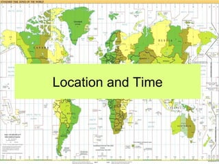
  • 20. Standard Time • As cross-country travel and communication became faster and more efficient, a standardized system of global time was required. • Given the Earth rotates once throughout a 24 hour period, 24 standard times zones were agreed upon at the 1884 International Prime Meridian Conference. • The local solar time at Greenwich, England was designated the prime meridian. Each time zone extends 7.5° on either side of a central meridian. • For years the global standard for reporting time was Greenwich mean time (GMT). GMT is now referred to as Universal Time Coordinated (UTC) but the prime meridian is still the reference for standard time.
  • 21. International Date LineFerdinand Magellan and crew in 1519 set out on their westward journey from Spain to circumnavigate the Earth. Upon their return three years later, they discovered that their meticulously kept logs were off by one day. This was one of the first recorded experience with changing global time. This earlier experience would ultimately lead to the establishment of the international date line. The International Date Line lies directly opposite of the prime meridian and having a longitude of 180°. Crossing the line when traveling east one turns their calendar back a full day. Traveling west one moves their calendar forward one day.
  • 22. Daylight Saving TimeDaylight Saving Time  Many countries observeMany countries observe daylight saving timedaylight saving time - the- the practice of setting clockspractice of setting clocks forward one hour in the springforward one hour in the spring and back one hour in the fall.and back one hour in the fall.  First proposed by BenjaminFirst proposed by Benjamin Franklin, the notion ofFranklin, the notion of extending daylight one hourextending daylight one hour into the evening didn't catchinto the evening didn't catch hold until World War One as ahold until World War One as a means of energy savings.means of energy savings.  Some countries, territories,Some countries, territories, and states in the U.S. do notand states in the U.S. do not observe daylight saving time.observe daylight saving time.
  • 23. Standard MeridiansStandard Meridians • There are 24 standard meridians. • They are all 15° apart. • The first standard meridian is the Prime Meridian. • Time does NOT change at the standard meridians. – The standard meridian is the middle of the time zone. – Time zones extend 7.5° on each side of the standard meridian.
  • 25.
  • 26. Assignment • Read Section Three: Location – Complete Problems-Part I 1 a-e, 2 a-e, Problems-Part II 1 a-e, 2 a-d, 3, and 4 • Read Section Four: Time – Complete Problems-Part I 1-4, Problems-Part II 1 a & b, 2, and 3 – Complete worksheet “Calculating Time” 1 a-d, 2, 3 a-e