GIS on the Rise in Citizen Engagement
•
0 likes•364 views

Downloadable mobile applications are promoting open government and citizen engagement as well as growing the community's authoritative GIS databases.

Recommended
Recommended
More Related Content
More from Esri
More from Esri (20)
Recently uploaded
Recently uploaded (20)
GIS on the Rise in Citizen Engagement
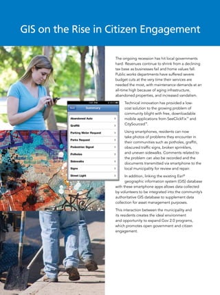
- 1. GIS on the Rise in Citizen Engagement The ongoing recession has hit local governments hard. Revenues continue to shrink from a declining tax base as businesses fail and home values fall. Public works departments have suffered severe budget cuts at the very time their services are needed the most, with maintenance demands at an all-time high because of aging infrastructure, abandoned properties, and increased vandalism. Technical innovation has provided a low- cost solution to the growing problem of community blight with free, downloadable mobile applications from SeeClickFix™ and CitySourced™. Using smartphones, residents can now take photos of problems they encounter in their communities such as potholes, graffiti, obscured traffic signs, broken sprinklers, and uneven sidewalks. Comments related to the problem can also be recorded and the documents transmitted via smartphone to the local municipality for review and repair. In addition, linking the existing Esri® geographic information system (GIS) database with these smartphone apps allows data collected by volunteers to be integrated into the community’s authoritative GIS database to supplement data collection for asset management purposes. This interaction between the municipality and its residents creates the ideal environment and opportunity to expand Gov 2.0 programs, which promotes open government and citizen engagement.
- 2. Smartphones Help New Haven Residents Resolve Community Problems New Haven, Connecticut, resident Ben Berkowitz had an epiphany after several unsuccessful telephone calls to city hall to report graffiti on a building adjacent to his property. “I thought, wouldn’t it be great if there was a way for a resident to easily submit common community concerns to the city so that they could be quickly reviewed and resolved?” says Berkowitz, founder of SeeClickFix. Within a few years, Berkowitz launched his company and released a free smartphone application to record and submit community complaints for resolution. The most common community complaints in New Haven are input directly into its authoritative GIS database for further processing by Cityworks® and ArcGIS® applications. New Haven implemented its GIS database several years ago and uses it for maintenance review, project planning, emergency response, and the many other responsibilities of the city. “Providing the opportunity for citizens to easily report these problems and then have that collected data geocoded and integrated into our database for use by our maintenance crews helps us organize our work more efficiently. This also leads to greater satisfaction in the community with the local government and its officials.” Rob Smuts, New Haven’s Chief Administrative Officer When citizen complaints are sent to the GIS database, a service request is created and the location of the incident geocoded so it can be viewed in ArcGIS for further evaluation. If appropriate, a work order is then generated from the service request. Geocoding is a critical step in the process because it allows the city to maintain its asset registry, so all public works activities can be associated with a feature (or asset) in the GIS database. The asset registry also preserves the history of infrastructure repairs and allows city managers to perform a variety of GIS analyses, such as evaluating areas with unusually high maintenance requirements to determine possible causes and take preventive measures if appropriate. This allows the city to maintain the public assets it is responsible for in a cost-effective manner. With the addition of the Cityworks application from Azteca Systems, Inc.®, New Haven was able to implement the staging area necessary to filter incidents reported by the community to SeeClickFix and populate its authoritative GIS database with citizen-collected data.
- 3. Community Involvement Drives enrollment forecasting and analysis, school boundary maintenance, student safety, disaster Los Angeles Unified School District planning, and facilities operations and management. Maintenance Because upkeep of the numerous LAUSD Responsible for educating more than facilities requires an army of administrative, 675,000 K–12 students annually, the Los maintenance, and technical staff that is Angeles Unified School District (LAUSD) is continually evaluating and processing the the second-largest public school district in many service requests submitted each day, the United States. Facilities include over the district decided to implement a data 750 K–12 schools, 200 learning centers, collection system that would allow campus and dozens of warehouses and storage members to easily report nonemergency yards within the sprawling 469 square issues. This would subsequently relieve miles of Los Angeles, California. the operations department of some of its The district has used Esri’s GIS software inspection and reporting responsibilities for many years to facilitate a number of and let it concentrate on the repair and administrative tasks including student maintenance of the school district’s assets.
- 4. In 2010, the district contracted with CitySourced to implement LAUSD Service Calls, a smartphone application permitting LAUSD students and faculty to report maintenance issues. “We wanted to take advantage of today’s technology and provide our community with an intuitive tool that allows [members] to easily document maintenance issues and send those reports directly to us so that we can resolve them,” says Danny Lu, LAUSD business analyst. “As an added benefit, by using the application, students and faculty members of LAUSD are provided with a sense of ownership while building community pride.” CitySourced uses Esri’s ArcGIS application programming interface (API) for smartphones in the LAUSD Service Calls application so that the school district can integrate the volunteered data from the incident reports with its authoritative ArcGIS database. “The LAUSD Service Calls implementation is an end-to-end solution. Incidents are recorded on the mobile devices and sent to the CitySourced servers hosted by Microsoft Azure. Our servers route the issues directly into LAUSD’s IBM Maximo asset management system as a service request, where they are reviewed and subsequently resolved by the district’s maintenance department.” Kurt Daradics, Director of Business Development at CitySourced To learn more about citizen engagement in GIS, register for the free webinar series at esri.com/pwcitizen or call us at 888-603-3207. Copyright © 2011 Esri. All rights reserved. Esri, the Esri globe logo, ArcGIS, and esri.com are trademarks, registered trademarks, or service marks of Esri in the United States, the European Community, or certain other jurisdictions. Other companies and products mentioned herein may be trademarks or registered trademarks of their respective trademark owners. 126967 3M07/11sh