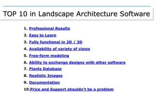
Landscape Design Software main features to look for by Landscape Architects, Urban Planners, Gardeners...
Principales características que los arquitectos paisajistas, urbanistas y jardineros deben buscar en los programas de paisajismo
John May's document outlines various design projects completed using CAD software like AutoCAD, SolidWorks, and Revit. The projects include assignments creating drawings using dimensions and layers in AutoCAD, a garage plan using external references and overlays, elevation plans for a garage created from roof plans, and a SolidWorks assembly of a drill press bracket from a blueprint. Other projects include designing parts for a radio flyer wagon in SolidWorks, redesigning a bookstore space in Revit, and designing plastic game pieces based on a client's idea. The document demonstrates skills in areas like 3D modeling, blueprint reading, assemblies, and generating drawings for fabrication.
This document contains summaries of various design projects completed by John May using CAD software such as AutoCAD, SolidWorks, and Revit. The projects include designs for garage plans, building elevations, a drill press bracket, radio flyer parts, and a bookstore redesign. For each project, John utilized skills such as dimensioning, layering, file referencing, assembly, drafting, and more to design and document 3D models and plans. The document demonstrates John's proficiency with multiple CAD programs and experience with various design and engineering tasks.
FREECAD is a free and open-source 3D CAD modeler and BIM software intended for mechanical engineering but also other engineering uses, with parametric modeling and finite element analysis support. NanoCAD is an easy-to-use CAD application that provides high performance and full capability for 2D drafting and 3D modeling in various industries using the DWG format. Sculptris is a virtual sculpting software focused on modeling clay and organic 3D models that can generate normal and displacement maps.
This document discusses various engineering software used for modeling, drafting, design, and analysis in civil engineering. It describes software for 2D and 3D CAD like AutoCAD, SketchUp, Revit, and Maya. It also covers analysis software like SAP 2000, STAAD Pro, and ETABS for designing and analyzing structures. Additionally, it mentions software tools for specialized tasks such as GIS for maps, SW-Road for road design, MATLAB for graphs and calculations, and MS Project and Oracle for project management and cost estimation.
Geo Information & Modeling Solution Pvt. Ltd is a company that provides 3D modeling services for real estate projects using Google Earth. They create detailed 3D models of projects that can be viewed globally in Google Earth. The models include buildings, landscaping, and surrounding areas to give customers an accurate sense of location. Customers can use the 3D models for marketing purposes by linking them to websites or including them in presentations. Geo Information & Modeling Solution has worked on many prestigious real estate projects in India.
AutoCAD LT 2013 is 2D drafting and detailing software that allows users to accurately document ideas, collaborate with others using DWG file format, and increase productivity with efficient drafting tools. It captures design concepts and produces precise technical drawings that can be easily edited and shared. The software provides comprehensive 2D tools for documentation, enables sharing work with colleagues through file collaboration, and focuses on intuitive interactions for improved productivity in design documentation.
AutoCAD LT 2013 is 2D drafting and detailing software that allows users to accurately document ideas, collaborate with others using DWG file format, and increase productivity with efficient drafting tools. It captures design concepts and produces precise technical drawings that can be easily edited, shared, and repurposed. Customers who viewed this item also looked at books about learning and mastering AutoCAD 2013 and AutoCAD LT 2013.
3D Modelling, Animation, Rendering, and Compositing Solutions for a variety of Industries, including Engineering and Architectural design (Building and Landscape), Motion Graphics, Game Design, and Film Editing.
Exploration and 3D GIS Software - MapInfo Professional Discover3D 2015Prakher Hajela Saxena
Pitney Bowes Software provides natural resource management solutions including GIS software for mineral exploration, mining, oil and gas, and forestry industries. Their solutions help users discover, evaluate, develop and manage natural assets. Their portfolio includes MapInfo Pro, Discover3D, and Engage3D Pro which provide spatial analysis, 3D modeling, and visualization capabilities for evaluating natural resource assets.
Civil Engineering all software information pdf Sonali117356
The document discusses various types of software used in architectural and structural design. It covers architectural software such as AutoCAD, Revit, Rhino, ArchiCAD, SketchUp, Canvas, and Lumion. It also discusses structural software such as STAAD Pro, ETABS, SAP2000, and ANSYS. The document then focuses on describing AutoCAD in more detail, covering its features, advantages, disadvantages, commands, and how to use layers and hatches.
The document discusses the need for computer applications in architecture. It describes how computers are used for construction documents, 3D models, presentation preparation, and allow architects to access more information about building projects through software programs. Specific applications discussed include CAD/CADD for drawings, SketchUp and Revit for 3D modeling, Photoshop for rendering and image editing, and Lumion for architectural visualization. The advantages of using computers include increased accuracy, consistency, ability to understand complex designs, and information access.
This document provides an overview and summaries of various Autodesk software products, including AutoCAD, AutoCAD Architecture, AutoCAD Civil 3D, AutoCAD Electrical, AutoCAD LT, AutoCAD Map 3D, AutoCAD Mechanical, AutoCAD MEP, AutoCAD P&ID, AutoCAD Plant 3D, AutoCAD Raster Design, AutoCAD Structural Detailing, and AutoCAD Utility Design. For each product, it lists the key features and capabilities in 1-2 concise sentences. The document is intended to introduce the various specialized Autodesk design and engineering software applications.
BIM in the Field: BIM for the Landscape ArchitectMarc Goldman
BIM is very well suited for more than tall structures or MEP coordination. A variety of tools are ready to be applied to the tasks of Landscape Architecture design and construction.
The document describes D-Reader, a software tool being developed by DII to automate the conversion of engineering drawings from scanned paper formats into 3D CAD models using artificial intelligence techniques. D-Reader uses computer vision and complex algorithms to extract engineering data from drawings, contextualize the information, and recreate the designs as 3D CAD files. This addresses the challenge of digitizing legacy engineering assets still contained in paper formats. The tool will help accelerate the global transition to digital formats by automating what is currently a manual process.
Is AutoCAD too expensive for your company? Consider these seven alternatives instead.
Autodesk is a juggernaut in the drafting industry—and they know it. While they tend to produce sleek, full-featured products, they come at a high cost.
Original post at http://blog.capterra.com/top-7-autocad-alternatives/?utm_medium=social&utm_campaign=slideshare&utm_source=linkedin
Be it an architecture or engineering design student, AutoCAD will likely be familiar to them. This widely popular digital drafting software is known for producing detailed drawings; however, its depth goes far beyond this initial impression. It provides an array of tools for 2D digital drawing, drafting and documentation as well as specialised ones for mechanical, electrical and architectural design which you can learn in autocad training.
Office room designers play a crucial role in creating efficient, aesthetically pleasing, and functional workspaces. To achieve this, they rely on a range of tools and software that aid in planning and visualizing office layouts. In this blog, we'll explore the essential tools and software that office room designers need to bring their design visions to life.
The document discusses software skills that are important for civil engineers to develop. It begins by stating that basic skills are needed in civil engineering and there is a need to develop additional skills. It then defines what software skills are and lists some common software used in industry, including MS Excel, AutoCAD, Revit, and STAAD Pro. For each software, it provides examples of how it is used in civil engineering for tasks like modeling, drafting, analysis, and documentation. It emphasizes that software skills are crucial for engineers to effectively perform their jobs and advance their careers.
Handout from my presentation at Autodesk University 2014 discussing how to coordinate civil and building models between Civil 3D, Revit, Navisworks, and InfraWorks.
This document discusses supporting multiple screens on Android. It covers challenges like resolution independence and density independence. Density can be managed through standard categories, though screens vary. The density-independent pixel (dp) is a virtual unit for design. Supporting multiple densities requires alternative graphic assets scaled at ratios like 3:4:6:8. Resources are provided for determining screen sizes, densities, and creating density-specific assets.
It presentation specialised application softwareNisarga Nikam
Specialized application software is designed for specific company or industry needs and includes programs like image editors, multimedia authoring programs, web authoring programs, and CAD software. Examples provided are Photoshop and Paint.NET for image editing, PowerPoint for multimedia authoring, Dreamweaver for web authoring, and AutoCAD for computer-aided design. Specialized software provides industry-specific tools and features beyond basic office programs.
Rayat institute of engineering and information technology(final)Yogesh Thakur
This document is a report submitted by Yogesh Thakur to fulfill the requirements for a six month industrial training program at IMPACT ENGINEERS in Mohali from April 19, 2016 to July 19, 2016. It includes an acknowledgement, candidate's declaration, preface, table of contents, and begins chapters on the introduction to AutoCAD, its history and features for architecture, advantages and disadvantages, entity types and descriptions, differences between CAD and AutoCAD, basic drawing commands, and text alignment options.
5 POPULAR 3D MODELLING SOFTWARE OPTIONSSonaliYadav50
BIMx, Live Home 3D, Onshape, SketchUp, and SkyCiv Structural 3D are some of the most popular 3D modeling software options. They allow users to create 3D models of buildings, homes, structures and other objects. Some key features include integrated 2D and 3D workflows for construction projects, automatically generating 3D perspectives based on floor plans, cloud-based collaboration, and structural analysis capabilities.
Explore the essential graphic design tools and software that can elevate your creative projects. Discover industry favorites and innovative solutions for stunning design results.
This document discusses various Revit add-ins that can help boost productivity for BIM professionals. It describes add-ins that specialize in areas like automation and programming, validation, visualization, import/export, and being general all-rounders. Specific add-ins highlighted include Dynamo, Enscape, V-Ray, Lumion LiveSync, and DiRoots. The document emphasizes that Revit professionals can streamline tasks and enhance their workflows using these third-party add-ins.
Similar to Top 10 Features Landscape Design Software (20)
My Fashion PPT is my presentation on fashion and TrendssMedhaRana1
This Presentation is in one way a guide to master the classic trends and become a timeless beauty. This will help the beginners who are out with the motto to excel and become a Pro Fashionista, this Presentation will provide them with easy but really useful ten ways to master the art of styles. Hope This Helps.
World trade center in kerala proposal- AR. DEEKSHITH MAROLI 724519251008 REPORTdeekshithmaroli666
World trade center live proposal in kerala.
Future of our nation is looking towards kerala..?
Yes, because the biggest sludge less port is going to open in kerala soon and also about the hidden massing growth of tourism, it , business sector
RPWORLD offers custom injection molding service to help customers develop products ramping up from prototypeing to end-use production. We can deliver your on-demand parts in as fast as 7 days.
2. Why these are the 10 top features
• Because these features are the
most requested and discussed in
professional landscape forums.
• Because they are the most
valued when selecting a
landscape software for
professionals.
• Because these are the buying
criteria for most of the landscape
designers and urban planners.
• Look for those features when choosing a landscape design software.
Here you will find the examples provided by Lands-Design.
3. TOP 10 in Landscape Architecture Software
1. Professional Results
2. Easy to Learn
3. Fully functional in 2D / 3D
4. Availability of variety of views
5. Free-form modeling
6. Ability to exchange designs with other software
7. Plants Database
8. Realistic Images
9. Documentation
10.Price and Support shouldn’t be a problem
4. 1. Professional Results
Landscape architects, urban planners, town council technicians, constructors, designers and draftsmen,
environment departments, nurserymen, and gardeners… all of them demand professional results, from technical
planning to photorealistic rendering.
It’s not just about obtaining a 2D drawing but getting terrain modeling, plants information, include watering
systems, civil works elements, furniture, 3D models, renderings, documentation. Lands Design provides them all.
5. 2. Easy to learn
Either by using the same commands and tools of an already known software or by using a really intuitive software.
Rhino and Lands Design interfaces are meant to be intuitive, customizable and easy to use.
Lands Design is fully integrated in Rhino, it uses the same workflow and all the Rhino editing tools and commands
to work with 2D and 3D objects can be combined with the Lands Design objects.
6. 3. Fully functional in 2D / 3D
Landscape designers must use 2D & 3D, depending on which part of project is being created. Customers enjoy 3D
because they see what they will get but designers need to develop their creation in 2D.
Lands Design offers different simultaneous 2D and 3D displays of vegetation on the drawing.
7. 4. Availability of variety of views
All projects should be shown with different display modes, virtual tours, animations, image filters to exploit all the
possibilities of the design.
Besides, Lands Design includes a variety of tools to distribute plants, trees, shrubs and flower beds, individually, in
rows, in forests…
8. 5. Free-form Modeling
It’s not just about obtaining a 2D drawing but getting 3D models, terrain modeling, plants information, include
watering systems, civil works elements, furniture, renderings, documentation. A balanced assembly of structural
elements and plants will give a highly attractive spatial composition.
Lands Design is a free-form modeling tool and incorporates a vast library of urban street equipment in two and
three dimensions, in order to meet the needs of landscaping professionals. Lands-Design can be used to easily
draw stairs, fences, paths, walls and other structural elements in both 2D and 3D.
9. 6. Ability to exchange designs with other software
Landscape designers need to share their projects with other designers or customers. It won’t possible unless their
software allows to export their designs to a compatible format.
Rhino can import and export AutoCAD drawing (.dwg) files. DWG is the native format for several CAD packages
and it’s included in Lands Design.
10. 7. Plants Database
What’s a landscape without plants? Nothing. Even if you are projecting an urban space, you need plants. Your
software must not be limited to provide images but all the information regarding the plants.
To make it easier, Lands Design has a database with around 1800 plant species. Realistic plants database with their
data, morphology and specific characteristics, such as the resistance or type of soil. The plants database can be
filtered by species, scientific or common name and characteristics.
11. 8. Realistic Images
Realism is necessary, not only for the landscape designer but also for the customer, whether they are private or
corporate. Their expectations will be satisfied if you submit realistic images of their orders.
Just insert plants and shot renders! All Lands Design elements and vegetation species can be rendered with any
render engine supported by Rhino: Rhino render, V-Ray, Flamingo nXt, Maxwell render, Brazil, Penguin, Neon …
12. 9. Documentation
The “other” side of the landscape design process. Apart from plans and renderings, a Landscape Architect needs
to obtain the documentation of the whole project.
Lands Design provides many features for the documentation including self-generated tables -exportable to Excel-,
plant labeling, spot dimensions, automatic schedules, space zoning and others.
13. 10. Price & Support shouldn’t be a problem
Even if you are lucky enough to afford to pay a high price, why should you be forced to pay an exorbitant price?
Lands Design is a WIP (Work In Progress) software and its DOWNLOAD IS FREE. There is a new WIP released every
3 months approximately. When the first commercial version is released, the introductory price will be determined.
Even then, it will fit into the pocket-friendly brand philosophy. Like its own community.
14. Try it for FREE
• Download Lands-Design with or without Rhino and Flamingo nXT
• Contact Lands Design for a free demo
• Visit the Lands Design Community
15. • Lands Studio for Autocad
• Bubble for Rhino
• VisualARQ
• Dynamic Display
Lands-Design is developed by ASUNI, the specialist in ARCHITECTURE – LANDSCAPE - ENGINEERING