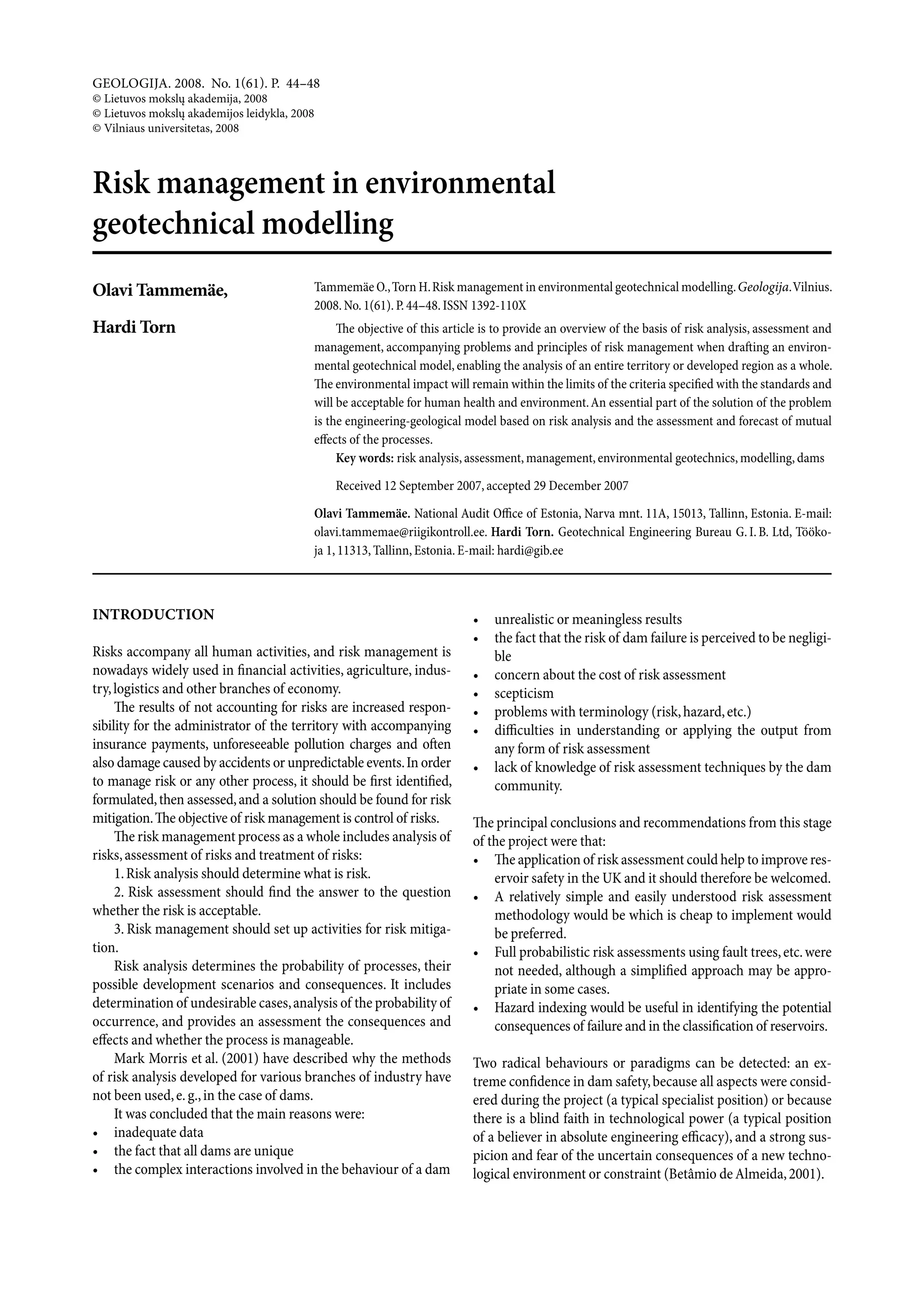
Download to read offline
![energy. The possibilities of our measuring and calculation techniques do not enable the third
possibility – an analysis on the basis of wave equation.
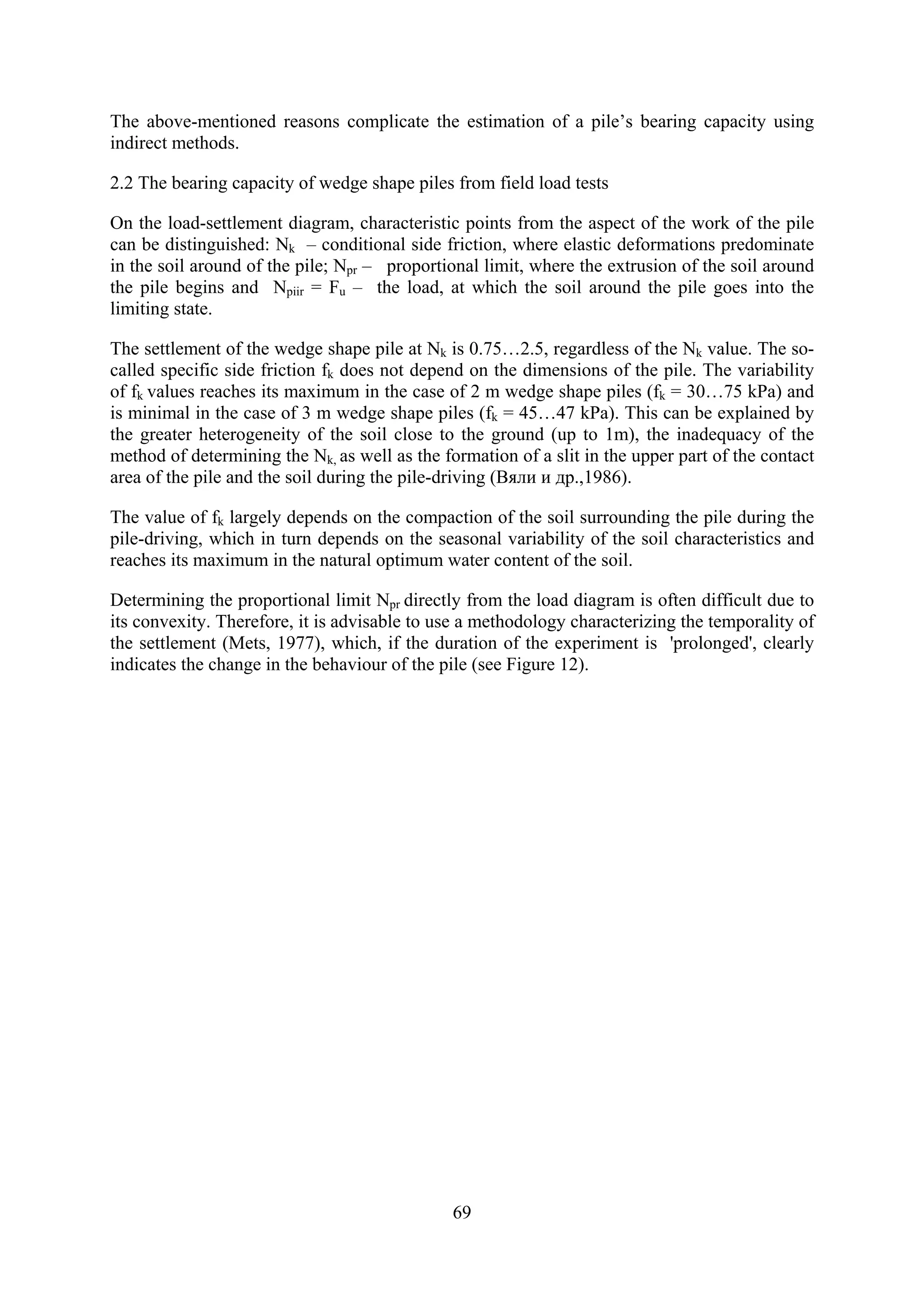
To assess the bearing capacity of wedge shape pile by means of a parallel, the
N.M.Gersevanov formula (SniP 2.02.03-85 formula 18) has been used in Estonia for a long
time now.
Since adequate formulas for wedge shape piles are lacking, Npr values from driving test data,
obtained by loading wedge shape piles, were compared with Gersevanov and Gate-Killar
formulas. Applying the Gersevanov formula, equivalents were below 1.5 cm Npr ≈ Fu/ γg γk ,
equivalents between 1.5…3.0 cm Npr ≈Fu , with higher equivalents Npr exceeds ultimate
bearing capacity Fu 1.5…2 times.
Gate Killar empiric formula
25
.
NG = K log Sa [ t ]
where
G – weight of falling part t,
H – effective falling height of falling part cm,
Sa – pile settlement from one blow cm,
K – 2, when Sa >0.5 cm, and K = 3, when Sa < 0.5 cm,
When applying NG should be equated with calculated bearing capacity, i.e. NG = Fu/ γg γk.
According to the test data, equivalents have 0.2…2 cm NG ≈Npr, equivalents over 2 cm have
NG ≈ 1,5Npr .
Since most wedge shape piles have been driven by Võru KEK diesel hammer, whose
parameters (weight and felling height of blowing part) have not changed, it was possible to
calculate the dependence of wedge shape pile Npr on equivalent Sa on the basis of the existing
data (figure 13).
Npr = 320 Sa – 0.29 (n = 53; r = - 0.87).
72](https://image.slidesharecdn.com/tammemebasicsforgeotechnicalengineeringexplorationsconsideringneededlegalchanges-100720104248-phpapp02/75/Tammemae-basics-for_geotechnical_engineering_explorations_considering_needed_legal_changes-72-2048.jpg)

![Oil Shale, 2006, Vol. 23, No. 2 ISSN 0208-189X
pp. 177–186 © 2006 Estonian Academy Publishers
ENVIRONMENTAL GEOTECHNICS IN THE
SERVICE OF SUSTAINABLE DEVELOPMENT
ON THE EXAMPLE OF NORTH-EAST ESTONIA
– SILLAMÄE
O. TAMMEMÄE(a), H. TORN*(b),
(a)
Estonian Ministry of Environment
Narva Rd. 7A, 15172 Tallinn, Estonia
(b)
Geotechnical Engineering Bureau G.I.B. Ltd.
Töökoja 1, 11313 Tallinn, Estonia
The aim of the current paper is to analyse the environmental problems
associated with harbour construction at Sillamäe, waste depositories (WD)
and recultivated areas in the mining industries, and to offer solutions that
would actually promote sustainable development. The authors have chosen
the Sillamäe WD as a sample area, for the complexity of problems in that
area makes the case a warning example.
Introduction
Human activities have affected the environment since the dawn of mankind;
with the acceleration of development, these influences and accompanying
risks have only grown. With the development of application of nuclear
energy, the issue of the human activities connected with radioactive waste
management has become topical all over the world. Uranium mines and their
inseparable satellites – radioactive waste repositories – can be found in 35
states [1]. These repositories differ from ordinary mine waste repositories by
the content of hazardous substances that migrate by air, dissolve into water
bodies, or filtrate into groundwater.
Disintegration of radioactive waste is a long-term process that humans
cannot control. Therefore, the only way to protect human health and nature
would be isolation of waste repositories from the immediate organic world.
One solution is to deposit the waste underground. This is an expensive and
often impossible undertaking, as the old mines are often destroyed, flooded,
or amortized. Another solution would be isolation of the WD from the
surrounding environment. Separating a WD from the organic world – the
process of sanitation – demands the co-operation of many specialists from
*
Corresponding author: e-mail hardi@gib.ee](https://image.slidesharecdn.com/tammemebasicsforgeotechnicalengineeringexplorationsconsideringneededlegalchanges-100720104248-phpapp02/75/Tammemae-basics-for_geotechnical_engineering_explorations_considering_needed_legal_changes-80-2048.jpg)
![178 O. Tammemäe, H. Torn
geologists to social scientists. At the same time, a waste depository is an
engineering construction that has to maintain its functionality and constancy
for hundreds of years irrespective of the reigning policies, legislation, or
currency.
In the mining industry, the environmental effects connected with WDs
and the recultivated areas often constitute the critical factor. These are
technogenic constructions that are associated with risks in the environ-
mental, medical, human resource and land use capacities. Ignoring these
risks results in higher responsibilities, bigger insurance fees, and pollution
taxes for the landholder
From the engineering-technological point of view, the closing down of a
WD and the recultivation of mines is a complicated process that requires the
consideration of a variety of important factors. A fundamental factor is the
geological make-up of the region and the geotechnical conditions at play
there. The environmental effects brought about by human influence on the
geosphere, also the accompanying risks and the possible solutions are
nowadays being studied within a new, evolving science – environmental
geotechnics – that combines in itself geology, hydrogeology, engineering
geology, geotechnics and other adjacent disciplines. The resulting synthesis
provides us with initial input that leads on to the evaluation of the environ-
mental condition and the planning of the sanitation process – an exploit that
has been followed actively since the 1950s. In the temporal context of
geological processes, this is a very short time.
The environmental impact of waste repositories and
the possibilities for alleviating those issues
The world practice in waste depository sanitation proves that problems will
rise in all the stages of the project – during investigation, in designing, at
sanitation works and during the future exploitation of the object. Even
though the aim is to isolate the depository entirely from the surrounding
environment – for a long time and with no further maintenance – experience
shows that the initial expectations tend to be fairly optimistic and the need
for accompanying environmental measures and extra investments usually
comes up much earlier than it has been foreseen [2].
On the one hand, the construction of waste repositories resembles other
engineering constructions that have been built for hydrotechnical purposes.
The difference appears at the assessment of the temporal factor and the risks.
The main problem in waste depository sanitation tends to be the lack of
experience in considering the time factor. Taking into account the lifespan of
radionuclides, waste repositories are supposed to “work” for a 1000 years (in
Scandinavia, 10,000 year periods are being considered).
Scientists comparing relative toxicity of highly radioactive compounds
and industrial uranium waste and its changes in time have reached very](https://image.slidesharecdn.com/tammemebasicsforgeotechnicalengineeringexplorationsconsideringneededlegalchanges-100720104248-phpapp02/75/Tammemae-basics-for_geotechnical_engineering_explorations_considering_needed_legal_changes-81-2048.jpg)
![Environmental Geotechnics in the Service of Sustainable Development … 179
interesting results. They compared radiotoxic hazard of these compounds
determining the amount of water needed for diminishing the content of each
radioactive element to the level that would correspond to the drinking water
standards [3]. The results are presented in Fig. 1.
The research results prove that the so-called “low-enriched” uranium waste
is one order of magnitude more toxic in its whole concentration range as
compared to the content of highly radioactive single elements, and the impact
of hazardous waste may go on for millions of years. This provokes the ques-
tion: how long should the estimated time period be, and are we able to
calculate such temporal distances, basing on contemporary know-how?
It is believed that depositories should function according to the set require-
ments for at least 200 years without any need for more serious maintenance.
Considering the time factor, the resistance of the used materials must be
assessed.
The predicted age of technogenic materials (e.g. concrete, geotextiles,
asphalt) is up to 100 years.
If natural soils are used, their resistance to weather and time can be
assessed during a longer period (e.g. investigations of the erosion crust of
silt- and clay soils) and, consequently, also a prognosis made about the
environmentally hazardous exploitation of waste repositories in the future.
Fig. 1. Comparison of toxicity of low-enriched uranium mill tailings
with radioactive elements from high-enriched uranium](https://image.slidesharecdn.com/tammemebasicsforgeotechnicalengineeringexplorationsconsideringneededlegalchanges-100720104248-phpapp02/75/Tammemae-basics-for_geotechnical_engineering_explorations_considering_needed_legal_changes-82-2048.jpg)
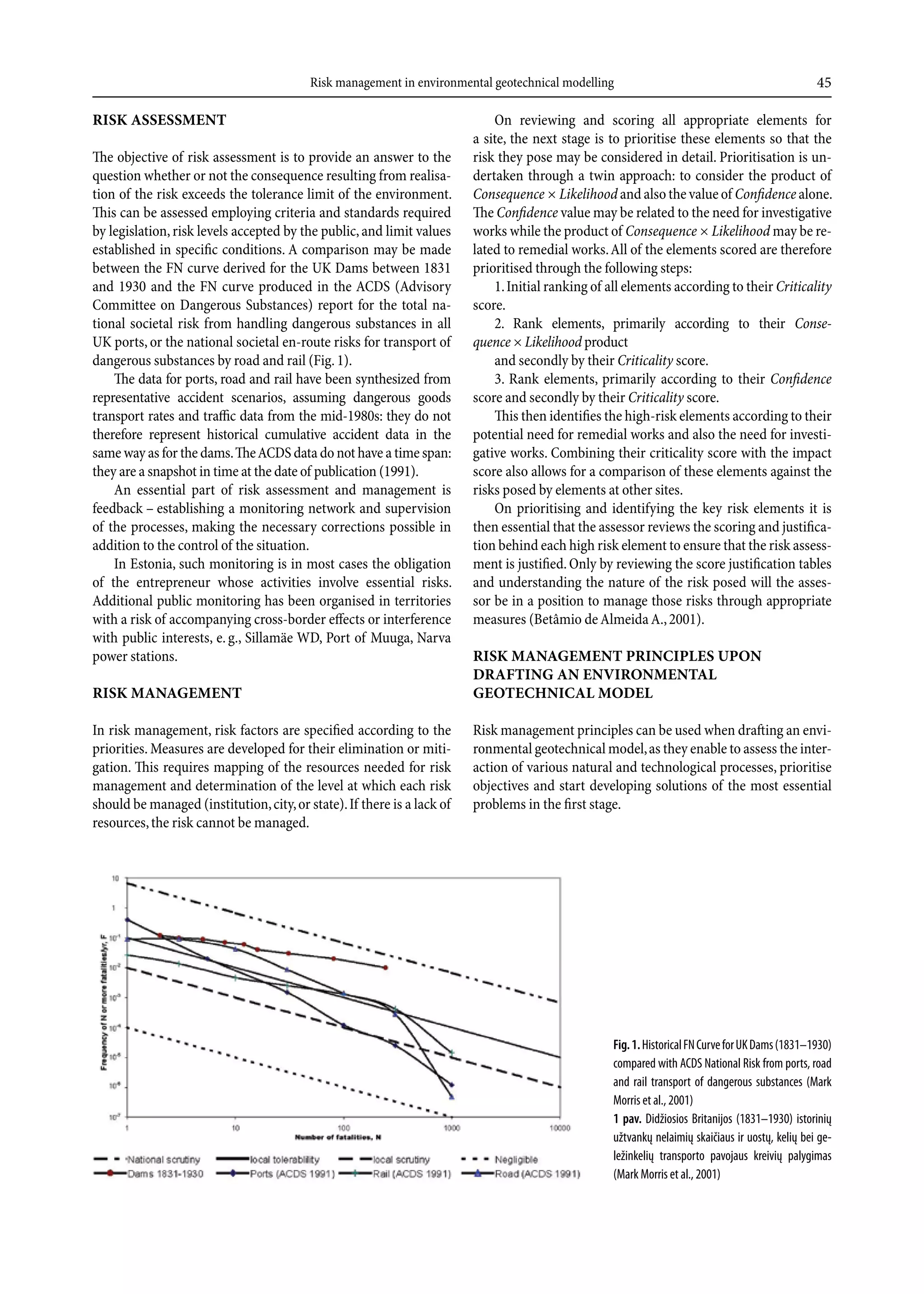
![182 O. Tammemäe, H. Torn
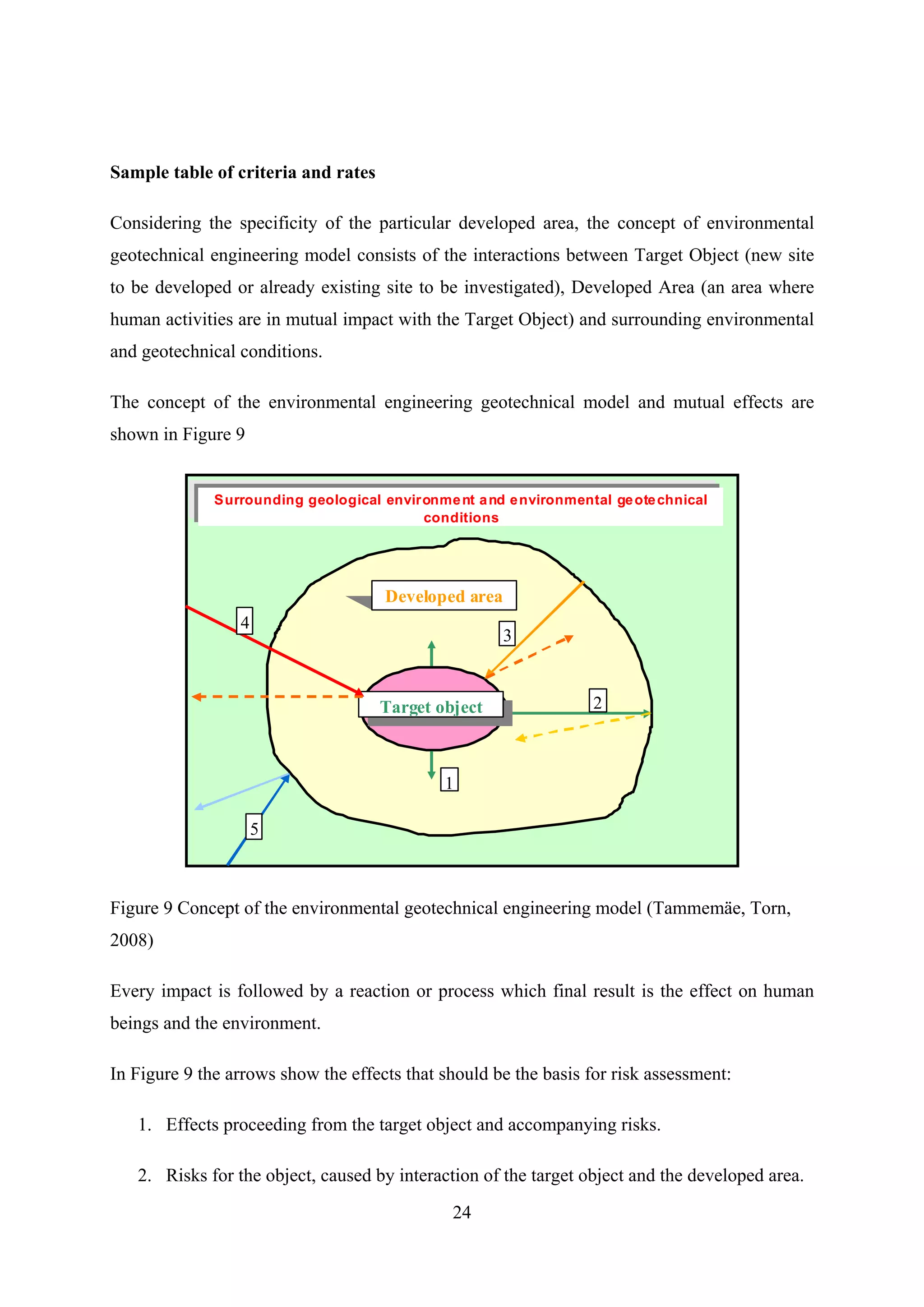
Fig. 2. The development plan of Sillamäe harbour and the free economic zone [4]
closed down and demolished. Now a modern, multifunctional commercial
port is planned to be erected here as a part of the Sillamäe free economic
zone. In the 1990s, preparations were made for constructing an oil port west
of the WD, but these plans remained unfulfilled mainly due to heightened
environmental requirements and the lack of sufficient resources for meeting
these demands.
The pulp and waste water accompanying the production of rare earth
metals, tantallium, and niobium is being channelled to the WD from the
Silmet factory. Contemporary waste contains a lot of nitric compounds and
other matter hazardous to the Baltic Sea.
Even though the amount of waste water is much smaller than a few years
ago, this kind of waste management does not meet the EU standards, and the
enterprise requires environmental reorganisation.
The shutting down of industrial production at Sillamäe resulted in
complicated social issues that are hard to solve. The hydrometallurgical
works along with the power station gives jobs to the majority of the Sillamäe
inhabitants, making it the main employer in the town. The social and
environmental issues of Sillamäe should therefore be viewed in the context
of the whole industrial region of Northwest Estonia.
In the future perspective – at a novel technological level – also repro-
duction of metals from waste and the underground deposition of hazardous
waste could be considered. Preliminary research has proved that lantanium
(La), scandium (Sc), niobium (Nb) and strontium (Sr) could all be produced](https://image.slidesharecdn.com/tammemebasicsforgeotechnicalengineeringexplorationsconsideringneededlegalchanges-100720104248-phpapp02/75/Tammemae-basics-for_geotechnical_engineering_explorations_considering_needed_legal_changes-85-2048.jpg)
![Environmental Geotechnics in the Service of Sustainable Development … 183
from the material deposited at the Sillamäe WD [5]. Currently, the produc-
tion of these metals would not be economically effective.
Joining the EU and the accompanying investments into infrastructure and
the development of small enterprising, the founding of the port and the
continuance of the plant create favourable preconditions for the development
and intensive use of the area in the future. As this is a territory that has been
in use for some time already, dangers and influences related to the former
exploitation of the area should be taken into account in the planning of new
enterprises and constructions. The main conditions determining the future
use of the territory will be economic, social, legislative and environmental-
geotechnical.
The investigations and prognoses that have been launched there point out
that the environmental-geotechnical conditions in the described territory are
very complicated. Many questions still remain unsolved. The main hindrance
to solving those problems is not even the lack of funding, but the lack of a
general conception and model. As investigations have proved [2], such a
conception appears to be missing in most of the recultivation projects in the
world.
The principles of the conception of
environmental-geotechnical model
It is especially important to develop an environmental-geotechnical model at
Sillamäe, because one of the most hazardous sources of pollution in the
Baltic Sea is situated there and dynamic human activity is foreseen in the
area in the future. All this calls for a finer definition of the goal, the starting
point and the criteria.
If the main aim is the closing down of the WD and its isolation from the
surrounding environment and further maintenance, then the starting point
should be the environmental-geotechnical conditions, their change in time
and the accompanying risks. The criteria should be made up of measurable
and assessable quantities, including the legislatively validated limits of
hazardous substances, the quantities of the slope processes/positions and
other quantities that depend on monitoring results.
If the aim is the founding and exploitation of the port, the starting point
should be the engineering-geotechnical conditions on which the tenacity of
engineering-technical buildings, the risks and environmental impact all
depend on. The criteria would again be comprised of the technical para-
meters that can be measured at monitoring.
If the aim is the environmentally sustainable development of the whole
developed region, the starting point should be the environmental-geo-
technical conditions of the whole surveyed territory and the affecting factors
as a whole. It is important to explicate the change of these conditioned by
time, also the tenacity of constructions and their mutual impact, the human](https://image.slidesharecdn.com/tammemebasicsforgeotechnicalengineeringexplorationsconsideringneededlegalchanges-100720104248-phpapp02/75/Tammemae-basics-for_geotechnical_engineering_explorations_considering_needed_legal_changes-86-2048.jpg)
![184 O. Tammemäe, H. Torn
impact and the accompanying risks. Processes, phenomena and influences
should be prioritised. The criteria should be determined on the basis of risk
analyses of the above-mentioned processes and impacts; by managing the
risks, they can be reduced to an acceptable level for both man and nature. It
is also important to acknowledge who will be responsible for managing the
risks and to estimate the required resources. If resources are deficient, the
risks cannot be managed.
The aims and principles of future environmental-geotechnical
investigations
The aims and content of the planned investigations will be determined in
accordance with the developments in the future use of the area, the monitor-
ing of the engineering-geological processes of the area and the results of risk
analyses. The main principle of the research methodology is the conceptuali-
sation of the area as one geomorphologic whole.
It must be taken into account that both geodynamic processes and geo-
technical conditions are influenced not only by a variety of technogenic pro-
cesses, but also by hydrometeorological conditions (changes in the water level
of the Gulf of Narva); it should also be assumed that traditional theories may
not necessarily apply for explaining and assessing the phenomena.
Up till now, undeservedly little attention has been paid to assessing the
impact of the technogenic factors [6, 7]. Even though the future possibilities
of utilising the old mines have to some extent been researched, these investi-
gations have neglected to take a comprehensive view of all the environ-
mental-geotechnical aspects. For example, the impact of the operating mines
on the hydrogeological conditions in the area still remains unclear; also the
possible impact of the hydrotechnical constructions of the future port on the
coastal processes and thus also on the slope reinforcements of the WD have
not been considered to the full. A northward-directed 510 m long mole and
the adjacent 730 m long quay cut across the leeward, east-bound current in
the lower part of the Sillamäe aquatory; they probably also influence the
compensating upwind current moving westward in the deeper part of the
aquatory.
Conclusions
The impact waste depositories will have on the surrounding environment in
the future intensive exploitation of the areas is an issue that has remained
unsolved all over the world. An important step in solving this problem is the
environmental-geotechnical model that is based on risk analysis and the
assessment and prognoses of reciprocated influences. In making the analyses
and giving evaluations, an important role is played by the information that is](https://image.slidesharecdn.com/tammemebasicsforgeotechnicalengineeringexplorationsconsideringneededlegalchanges-100720104248-phpapp02/75/Tammemae-basics-for_geotechnical_engineering_explorations_considering_needed_legal_changes-87-2048.jpg)
![186 O. Tammemäe, H. Torn
REFERENCES
1. www.antenna.nl/wise/uranium/
2. Torn, H. The evaluation of engineering-geological and geoecological conditions
at Sillamäe Radioactive Tailing Pond. Magister thesis, Tallinn Technical
University, Tallinn, 2003.
3. Pigford, T. H., Choi, Jor-Shan. Effect of fuel cycle alternatives on nuclear waste
management. In: Post, R. G. (ed.) Proceedings of the Symposium on Waste
Management, Tucson, Arizona, October 3–6, 1976. U.S. Energy Research and
Development Administration ERDA Report CONF-761020.
4. www.ecosil.ee
5. Turning a Problem into a Resource: Remediation and Waste Management at the
Sillamäe Site, Estonia., NATO Science Series., Series 1:Disarmament
Technologies – Vol. 28, Kluwer Academic Publishers, London, 2000, ISBN
0-7923-6186-5 (HB).
6. Tammemäe,O. 1996. Application of environmental geology on the example of
Port of Sillamäe. Congress of Estonian Scientists 1996. Proceedings of presenta-
tions, Tallinn 1996, p. 232 [in Estonian].
7. Tammemäe,O. 1995. Environmental Impact Assessment as a means of environ-
mental risk management on the example of Estonian ports. Proceedings of the
Conference “Ecological safety of Baltic countries, Nordic countries and North-
Western Russia”. Lohusalu, Estonia from March 30th to April 1st 1995, pp. 39–48
[in Estonian].
Presented by A. Raukas
Received November 23, 2005](https://image.slidesharecdn.com/tammemebasicsforgeotechnicalengineeringexplorationsconsideringneededlegalchanges-100720104248-phpapp02/75/Tammemae-basics-for_geotechnical_engineering_explorations_considering_needed_legal_changes-89-2048.jpg)
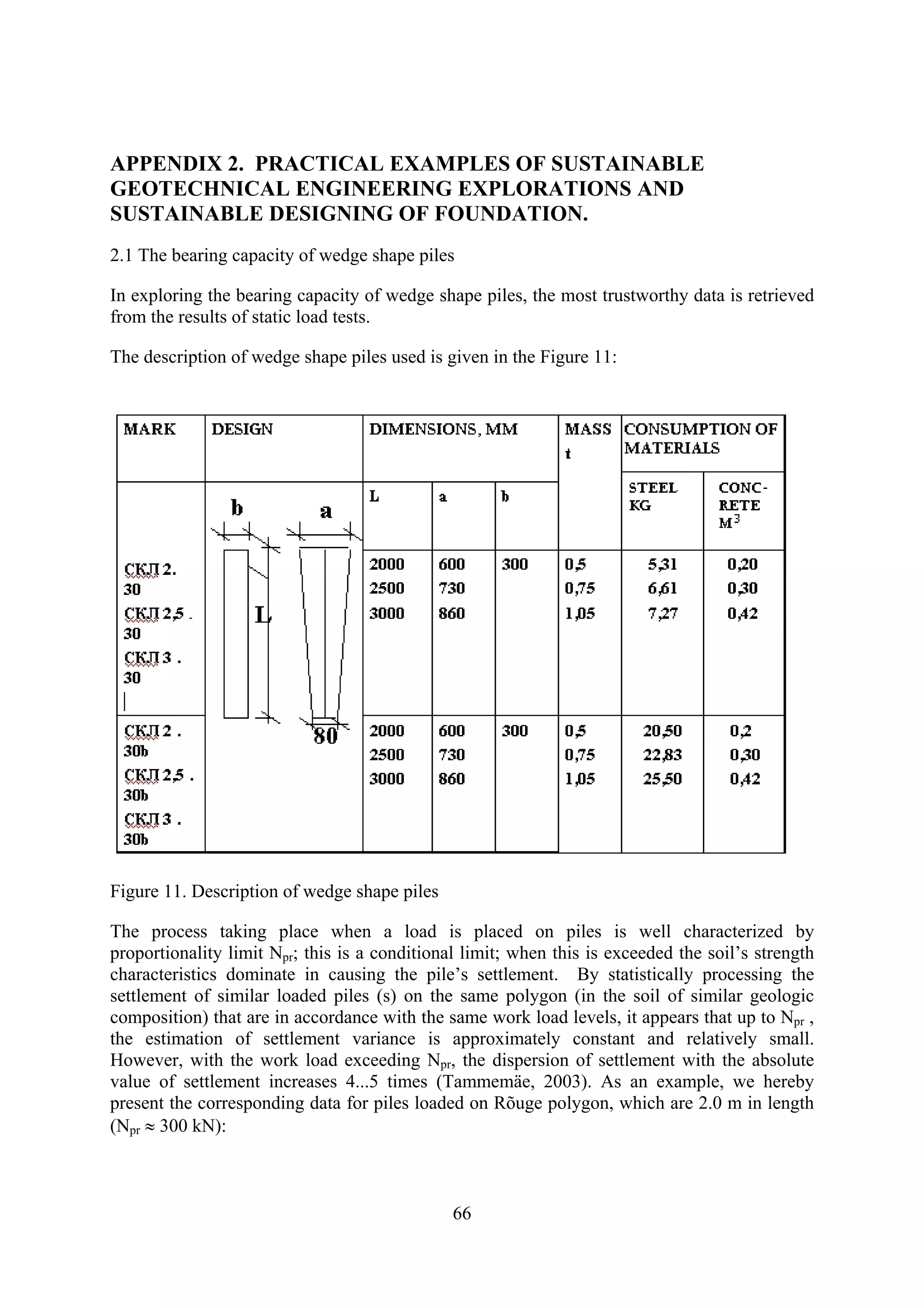
![Oil Shale, 2008, Vol. 25, No. 2 Special ISSN 0208-189X
pp. 1–1 © 2008 Estonian Academy Publishers
BASICS FOR GEOTECHNICAL ENGINEERING
EXPLORATIONS CONSIDERING NEEDED LEGAL
CHANGES FOR MINED AREAS AS WELL
O. TAMMEMÄE*
National Audit Office of Estonia
11a, Narva Rd.
15013 Tallinn, Estonia
Nowadays legal system does not cover essential aspects related to geo-
technical engineering explorations for assessing environmental risks to be
considered during planning processes and for providing designers with
reliable geotechnical parameters for sustainable construction solutions. The
absence of appropriate legal regulation does not support the reuse of mined
areas and sustainable use of mineral recourses. The article deals with
analysis on planning and building sectors with concrete suggestions for
changes in legal regulations. Additionally radon level survey and geo-
technical inspection related issues have analysed in the frame of risk
assessment. Both of the above issues are especially important to be
considered in mined areas. The utilisation of previous research data and re-
establishment of Geotechnical Fund will enable a much more economical use
of the available resources and a better management of possible risks.
Introduction
All types of planned (or unplanned) changes to the natural or man-made
environment are accompanied by a certain impact, the scope of which
depends upon the vulnerability of the affected environment and the current
load on it as well as on the characteristics of other changes. The same goes
for activities which change soil stress conditions.
In order to estimate and, if possible, prevent/minimise the environmental
impact accompanying human activities, including extraction of mineral
recourses, we must be able to predict them in advance.
The Building Act [1], above all its § 20, deals with geotechnical site
investigations. According to section 1, the objective of the geotechnical and
geodetic survey (hereinafter referred to by a single definition – site investi-
*
Corresponding author: e-mail: olavi.tammemae@riigikontroll.ee](https://image.slidesharecdn.com/tammemebasicsforgeotechnicalengineeringexplorationsconsideringneededlegalchanges-100720104248-phpapp02/75/Tammemae-basics-for_geotechnical_engineering_explorations_considering_needed_legal_changes-95-2048.jpg)
![2 O. Tammemäe
gations) is to obtain the necessary primary data for site planning, designing
of construction projects and construction. Site planning is prescribed in the
Planning Act [2].
Plans
Unfortunately, at the moment, the requirement for the performance of geo-
technical engineering studies for preparation of plans is totally absent from
the Planning Act [2]. This may lead to construction and infrastructure plan-
ning of unsuitable plots.
Pursuant to the Planning Act [2], plans fall into four cateories: national
spatial plans, county plans, general plans and detailed plans. The objective of
national spatial planning is generalised strategic treatment of the develop-
ment of state territory and human settlements, in the course of which there is
created, above all, a spatial basis for the regional development of the state,
which means that in the case of that planning phase the location of con-
structions is not designated.
The objective of county planning is generalised treatment of the develop-
ment of county territories, the terms for the development of settlements and
the designation of locations for critical infrastructure objects. Regarding this
planning, spatial construction is planned more specifically, among other
things general terms of use of land and water are designated; corridors for
roads, railroads, waterways and technical networks, the locations of airports,
harbours and waste storage sites and other technical constructions are
designated as well.
The objective of general planning is the designation of policies and
conditions for the development of the territories of local municipalities,
cities and the preparation of basis with the obligation of detailed planning for
sites outside cities and rural settlements. At the same time, during the
general planning stage, possible dangers and risks occurring afterwards
during the course of construction and development activity are to be
evaluated. Pursuant to risk assessment, limits or conditions can be assigned
construction sites. Risk analysis establishes the consequences and effects,
and the extent to which the process is manageable.
The objective of risk analysis is to provide an answer to the question of
whether the given enviromental risk is acceptable. This can be evaluated
using criteria and norms authorised by legislation, the levels of risk accepted
by the public, and limit values established in specific conditions. A critical
part of risk assessment is the observation network and monitoring of pro-
cesses which, in addition to control of the situation, allow of the necessary
corrections to be made.
Risk factors are ranked in the course of risk management according to
priorities; methods have been developed for their removal or mitigation. In
order to do so, the necessary resource for the management of risks must be](https://image.slidesharecdn.com/tammemebasicsforgeotechnicalengineeringexplorationsconsideringneededlegalchanges-100720104248-phpapp02/75/Tammemae-basics-for_geotechnical_engineering_explorations_considering_needed_legal_changes-96-2048.jpg)
![4 O. Tammemäe
Construction
Prerequisites for optimal foundation and construction solutions are the
availability of primary data of high quality for design work. Geotechnical
engineering data describing the area to be occupied by construction works
are of great importance. Under the current conditions of an ever increasing
deficiency in natural construction materials it is especially important to find
as many opportunities for the most economical use of natural resources as
possible.
According to Building Act § 3 (4) [1], the structure must not pose a
danger to the lives of its users or other persons, their health, property or the
environment. According to the Chemicals Act [3], emanation of dangerous
chemicals from the structure must be prevented. In addition, emanation of
noise and radiation harmful to people, poisoning or pollution of the soil and
water, emanation of waste water, smoke, and poor disposal of solid or liquid
residues from the construction works must be prevented. Humidity may not
accumulate in the parts or surfaces of the structure in such a manner that it
poses a threat to the lives, health, or property of the people. The Building
Act does not prescribe a sufficient amount of mechanisms or necessary
regulations in order to satisfy such a requirement.
It is possible to revoke a building permit if the structure being built is
hazardous to the lives of people, their health, property, or to the environ-
ment. Pursuant to section 40, the owner of such a structure must bring the
structure into compliance with the corresponding requirements presented for
the building or destroy it by the date designated in the precept, and according
to the method and conditions therein. The described provision in itself
should ensure that the structures not complying with standards are not built.
At the same time, the provision is too general in its contents to allow it to be
successfully implemented in practice.
The regulation in the Building Act [1] regarding geotechnical engineering
surveys is unclear. The regulation given in the Building Act does not
uniformly designate whether the performance of site investigations is
required before the preparation/construction work of the building design
documentation or not. Also, contents of the term of validity of geotechnical
engineering survey works performed is not prescribed – whether works
prepared several years ago can serve as the basis for the construction of
specific structures. The regulation does not foresee the procedure of return
and repair of the works in the case of their non-compliance with the require-
ments of laws. Thus, the Building Act regulation requires supplementation in
terms of its conditions, for which the performance of a site investigation is
mandatory and in the designing stage it is to be conducted.
The procedure for the performance of site investigations lacks specific
requirements for the performance of investigations and the minimum volume
of investigation required.](https://image.slidesharecdn.com/tammemebasicsforgeotechnicalengineeringexplorationsconsideringneededlegalchanges-100720104248-phpapp02/75/Tammemae-basics-for_geotechnical_engineering_explorations_considering_needed_legal_changes-98-2048.jpg)
![Basics for Geotechnical Engineering Explorations... 5
The representative limit of the necessary geotechnical engineering data
needed to ensure economical solutions of the project depends on both the
complexity of the building and its loads as well as on the strength of the
foundation and variation in soil properties, possible geologic processes,
including underground water regime, the possible emanation of radon, and
the occurrence of mined-out areas. The output of economical solutions of
projects is an economically effective stable building constructed environ-
mentally friendly and efficiently , which at the same time ensures a secure
and healthy man-made environment.
All this holds also for structures (railroads and highways, airports, dams,
wharfs, garbage dumps, collectors, and other infrastructure elements).
As the methodology for geotechnical engineering explorations and
technical equipment needed are largely similar to those used for mineral
survey, it is reasonable to consider the possibility of drafting necessary
amendments to the Earth Crust Act instead of amending the Building Act.
Radon level surveys
The air in every house contains a certain amount of radon, although the level
of radon varies, depending upon the geological conditions, the construction
of the house and the quality of the structure. Radon levels also change over
time. The Radiation Act [4] does not regulate exposure caused by radon in
dwellings and mined areas. Pursuant to § 6 (1) of Minister of the Environ-
ment regulation No 45 of 26 May 2005 [5], “The surveillance of exposed
workers and residents, the values of doses, dose factors, radiation and tissue
factors caused by the intake of radionuclides”, the surveillance of radon in
the air of premises is part of the surveillance series. The frequency of
surveillance measurements in the case of radon and the surveillance of its
long-term progeny in drinking water is at least once per year, radon
surveillance in the air of premises – at least once every three years.
The radon risk map has to be taken into consideration during the pre-
paration of the planning phase. It is also possible through legislation to pre-
scribe a soil classification on the basis of radon emissions and, basing on
that, to prescribe the application of inevitable measures, by adding the
corresponding authorisation standard in the Building Act [1]. In the mined-
out areas – especially in the oil shale basin and the phosphorite field
(Maardu) where the Dictyonema argillite has been opened – radon-related
risks are considerable.
Since the given survey involves environmental research, the supple-
mentation of the Environmental Impact Assessment Act and the Environ-
mental Management System Act [6] may be weighed in terms of the assess-
ment of environmental impact. According to the mentioned legislation, the
environmental impact of planned activities may be evaluated during the
preparation of the construction project as well as during the proceedings for](https://image.slidesharecdn.com/tammemebasicsforgeotechnicalengineeringexplorationsconsideringneededlegalchanges-100720104248-phpapp02/75/Tammemae-basics-for_geotechnical_engineering_explorations_considering_needed_legal_changes-99-2048.jpg)

This document discusses the need for changes to Estonia's legal framework regarding geotechnical engineering explorations. It analyzes how the current laws do not adequately cover important aspects of explorations for environmental risk assessment, planning, and sustainable construction. The author proposes several amendments to existing acts, such as requiring explorations for planning processes. Practical examples are given of how failing to consider geotechnical factors can lead to issues like subsidence or landslides. The utilization of past research data and risk management principles are discussed as important for sustainable development and reducing health and economic impacts.


