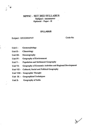
MPPSC - SET 2022 SYLLABUS
Subject:geography
Optional- Paper -II
SYLLABUS
Subject: GEOGRAPHY Code No
UnitI- Geomorphology
Unit II- Climatology
UnitIII- Oceanography
UnitIV- Geography ofEnvironment
UnitV - Population and Settlement Geography
Unit VI- Geography ofEconomic Activities and RegionalDevelopment
Unit VII- Cultural,Social and Political Geography
Unit VIII - Geographic Thought
Unit IX - GeographicalTechniques
UnitX- Geography ofIndia
UNIT-I
Geomorphology
Continental Drift, Plate Tectonics, Endogenetic and Exogenetic forces.
Denudation and Weathering, Geomorphic Cycle(Davis and Penck), Theories and
Process of Slope Development, Earth Movements (seismicity, folding, faulting
and vulcanicity), Landform Occurrence and Causes of Geomorphic Hazards
(earthquakes,volcanoes,landslides and avalanches)
UNIT-II
Climatology
Composition and Structure of Atmosphere; Insolation, Heat Budget of Earth,
Temperature,Pressure and Winds,Atmospheric Circulation(air-masses,fronts and
upper air circulation, cyclones and anticyclones(tropical and temperate). Climatic
Classification of Koppen & Thornthwaite, ENSO Events (El Nino, La Nina and
Southern Oscillations), Meteorological Hazards and Disasters (Cyclones,
Thunderstorms, Tornadoes, Hailstorms, Heat and Cold waves Drought and
Cloudburst , Glacial Lake Outburst (GLOF), Climate Change: Evidences and
Causes ofClimatic Change inthe past.Human impacton Global Climate.
UNIT-III
Oceanography
ReliefofOceans,Composition: Temperature,Density and Salinity, Circulation:
Warm and Cold Currents, Waves,Tides,Sea Level Changes,Hazards;Tsunami
and Cyclone
UNIT -IV
Geography ofEnvironment
Components: Ecosystem (Geographic Classification) and Human Ecology,
Functions: Trophic Levels,Energy Flows, Cycles(geo-chemical, carbon, nitrogen
and oxygen),Food Chain,Food Web and Ecological Pyramid,Human Interaction
and Impacts,EnvironmentalEthics and Deep Ecology,EnvironmentalHazards and
Disasters (Global Warming, Urban Heat Island, Atmospheric Pollution, Water
Pollution, Land Degradation), National Programmes and Policies: Legal
Framework, Environmental Policy, International Treaties, International
Programmes and Polices (Brundtland Commission, Kyoto Protocol, Agenda 21,
Sustainable Development Goals,Paris Agreement)
V
UNTT-V
Population and Settlement Geography
Population Geography
Sources of population data (census, sample surveys and vital statistics, data
reliability and errors). World Population Distribution (measures, patterns and
determinants). World Population Growth (prehistoric to modem period).
Demographic Transition, Theories of Population Growth (Malthus, Sadler, and
Ricardo). Fertility and Mortality Analysis (indices, determinants and world
patterns). Migration (types, causes and consequences and models). Population
Composition and Characteristics(age,sex, rural-urban, occupational structure and
educationallevels),PopulationPolicies in Developed and Developing Countries.
Settlement Geography
Rural Settlements (types, patterns and distribution), Contemporary Problems of
Rural Settlements(rural-urban migration; land use changes; land acquisition and
transactions), Theories ofOrigin ofTowns(Gordon Childe, Henri Pirenne,Lewis
Mumford), Characteristics and Processes of Urbanization in Developed and
Developing Countries (factors of urban growth, trends of urbanisation, size,
structure and functions ofurban areas). Urban Systems(the law ofthe primate city
and rank size rule) Central Place Theories (Christaller and Losch), Internal
Structure ofthe City, Models of Urban Land Use(Burgess, Harris and Ullman ,
and Hoyt), Concepts of Megacities, Global Cities and Edge Cities, Changing
Urban Forms (peri-urban areas, rural-urban fringe, suburban ,ring and satellite
towns). Social Segregation in the City,Urban Social Area Analysis, Manifestation
ofPoverty inthe City(slums,informalsector growth,crime and social exclusion).
Unit-VI:
Geography ofEconomic Activities and RegionalDevelopment
Economic Geography
Factors affecting spatial organisation ofeconomic activities (primary, secondary,
tertiary and quartemary), Natural Resources (classification, distribution and
associated problems). Natural Resources Management. World Energy Crises in
Developed and Developing Countries.
-1
Agricultural Geography
Land capability classification and Land Use Planning,Cropping Pattern: Methods
of delineating crop combination regions (Weaver, Doi and Rafiullah), Crop
diversification, Von Thunen's Model of Land Use Planning. Measurement and
Determinants of Agricultural Productivity, Regional variations in Agricultural
Productivity,Agricultural Systems ofthe World.
Industrial Geography
Classification ofIndustries, Factors ofIndustrial Location; Theories ofIndustrial
Location(A. Weber,E. M.Hoover, August Losch, A. Pred and D. M. Smith).
World IndustrialRegions,ImpactofGlobalisation on manufacturing sector inLess
Developed Countries, Tourism Industry, World distribution and growth of
Information And Communication Technology(ICT) and Knowledge Production
(Education and R&D)Industries.
Geography ofTransportand Trade
Theories and Models of spatial interaction (Edward Ullman and M. E. Hurst)
Measures and Indices of connectivity and accessibility; Spatial Flow Models:
Gravity Model and its variants. World Trade Organisation, Globalisation and
Liberalisation and World Trade Patterns.Problems and Prospects ofInter and Intra
Regional Cooperation and Trade.
RegionalDevelopment
Typology ofRegions,Formal and Fictional Regions, World Regional Disparities,
Theories of Regional Development(Albert O. Hirschman, Gunnar Myrdal, John
Friedman, Dependency theory of Underdevelopment, Global Economic Blocks,
RegionalDevelopmentand SocialMovements inIndia
Unit-VII:Cultural,Social and Political Geography
Culturaland Social Geography
Concept of Culture, Cultural Complexes, Areas and Region, Cultural Heritage,
Cultural Ecology. Cultural Convergence, Social Structure and Processes, Social
Well-being and Quality ofLife, Social Exclusion, Spatial distribution of social
groups in India(Tribe, Caste,Religion and Language),Environment and Human
Health,Diseases Ecology,Nutritional Status(etiological conditions, classification
and spatial and seasonal distributional patterns with special reference to India)
Health Care Planning and Policies inIndia,Medical Tourism inIndia.
-}
Political Geography
Boundaries and Frontiers(with specialreference to India),Heartland and Rimland
Theories. Trends and Developments in Political Geography, Geography of
Federalism, Electoral Reforms in India, Determinants of Electoral Behaviour,
Geopolitics ofClimate Change, Geopolitics of World Resources, Geo-politics of
India Ocean, Regional Organisations of Cooperation(SAARC, ASEAN, OPEC,
EU).Neopolitics ofWorld Natural Resources.
Unit VIII: Geographic Thought
Contributions ofGreek,Roman,Arab,Chinese and Indian Scholars,Contributions
ofGeographers(Bemhardus Varenius,Immanuel Kant,Alexander von Humboldt,
Carl Ritter,Scheafer & Hartshorne),Impact ofDarwinian Theory on Geographical
Thought. Contemporary trends in Indian Geography: Cartography, Thematic and
Methodological contributions. Major Geographic Traditions(Earth Science, man-
environment relationship, area studies and spatial analysis). Dualisms in
Geographic Studies (physical vs. human, regional vs. systematic, qualitative vs.
quantitative, ideographic vs. nomothetic). Paradigm Shift, Perspectives in
Geography(Positivism,Behaviouralism,Humanism,Structuralism,Feminism and
Postmodernism).
UnitIX:Geographical Techniques
Sources of Geographic Information and Data (spatial and non-spatial), Types of
Maps, Techniques of Map Making (Choropleth, Isarithmic, Dasymetric,
Chorochromatic, Flow Maps) Data Representation on Maps (Pie diagrams. Bar
diagrams and Line Graph, GIS Database (raster and vector data formats and
attribute data formats).Functions ofGIS(conversion,editing and analysis).Digital
Elevation Model(DEM),Georeferencing(coordinate system and map projections
and Datum), GIS Applications(thematic cartography, spatial decision support
system). Basics of Remote Sensing (Electromagnetic Spectrum, Sensors and
Platforms, Resolution and Types, Elements of Air Photo and Satellite Image
Interpretation and Photogrammetry), Types ofAerial Photographs, Digital Image
Processing: Developments in Remote Sensing Technology and Big Data Sharing
and its applications in Natural Resources Management in India, GPS Components
(space, ground control and receiver segments) and Applications, Applications of
Measures ofCentral Tendency, Dispersion and Inequalities, Sampling, Sampling
Procedure and Hypothesis Testing {chi square test, t test, ANOVA),Time Series
Analysis, Correlation and Regression Analysis, Measurement ofIndices, Making
Indicators Scale Free, Computation of Composite Index, Principal Component
Analysis and Cluster Analysis, Morphometric Analysis: Ordering of Streams,
Bifurcation Ratio, Drainage Density and Drainage Frequency, Basin Circularity
Ratio and Form Factor, Profiles, Slope Analysis, Clinographic Curve,
Hypsographic Curve and Altimetric Frequency Graph.
Unit-X:Geography ofIndia
Major Physiographic Regions and their Characteristics; Drainage System
(Himalayan and Peninsular), Climate: Seasonal Weather Characteristics, Climatic
Divisions, Indian Monsoon (mechanism and characteristics). Jet Streams and
Himalayan Cryosphere, Types and Distribution of Natural Resources: Soil,
Vegetation, Water, Mineral and Marine Resources. Population Characteristics
(spatial patterns ofdistribution), Grovrth and Composition (rural-urban, age, sex,
occupational, educational, ethnic and religious). Determinants of Population,
Population Policies in India, Agriculture(Production, Productivity and Yield of
Major Food Crops), Major Crop Regions, Regional Variations in Agricultural
Development, Environmental, Technological and Institutional Factors affecting
Indian Agriculture; Agro-Climatic Zones, Green Revolution, Food Security and
Rightto Food.Industrial Developmentsince Independence,Industrial Regions and
their characteristics, Industrial Policies in India. Development and Patterns of
Transport Networks (railways, roadways, waterways, airways and pipelines).
Internal and External Trade (trend, composition and directions). Regional
Development Planning in India, Globalisation and its impact on Indian Economy,
Natural Disasters in India (Earthquake, Drought, Flood, Cyclone, Tsunami,
Himalayan Highland Hazards and Disasters.)
«/
wr
'mm -22
^cpi^ I—^3l|c|>[cl Rl^lN
II—vTietqi^ R5IM
III-^?Tg^
iv-'q^rhw
?cjyi^ v-uhWtt^ ^»jt1ct
^cITlf Vl-3nf^ JlRlto sfl^ f^cbH W ^jrfr^
^ciTi^ V]i-w<^f^, wnf^
$q?l4 VIII—■'fhftfef^ Fqai
ix-^Vilf^4)
I
^ fM^f^, ^jiciRch ^1 t^ct ot^rt,
T^|c|^[r|c|> W ^ "^^I^), wr tor?T ^ %^EfKT afK WT,
^TeR,^ Mdldl^xl^ildl), ^
c^ cf)RTTj (^CPH, ^MI^V^,'^^-WSleld, f^*1t<£lcl'l)
II
uldcliy %rR
cll^H^d ^^RcFTT 'diiluH, ^ dR 3fr^
MR'd-d>!Ui (crr^-xiiRiiii, dTdirr crtt c[rg?Rg^ cn^ dfiidTd
"RfcRsfjdld "^ftdTM 0[c6jtili|), crTiHi ^ ^ uT^TdT^ d^ffcfF^,
ENSO dddR (EL-NINO, LA NINA #? ^Wd), #? STRdR (WdTd,
df^d ■^TT^T, dtRT^, 3fr^ dRT ^ ^ffd d^, wWici, fid sHel yWic^
(GLOF), vTcTWg hRci^'I: fidd dWldi ^ vjldcjl^ hRc] c^ '^dSd tdK"l, ^f^dd?
vrtdcll^ d? dTdd dd ^IdTcri
III
f^lTH
dWdccf, ddtdR: dlMHH, dddT sff^ eRRTdT, dddd: d4 d^ e[RR, dT^,
^^dR-dTdT, ^dgd "^d? mRcIcSh. dd^d: gdPff dd dsbcJld
IV
ddcp; drf^Rcb'ld (#rftfif^f? cFffe^) 3ik dHcT qrf^^^dMtd, f^JdR: dtW
yc|i5, dSdT (''J-^^ndd, dd^d, dT^^fdpT dd SdfcRTvTd) ^dT^d -^^aoll, ^IdT^d vTTeT, 3fR'
yiRR*yRcb f^tdf^Td, HUcSlii m^i'wRcb sfd^fer afF? wd, ddfdFftd ^Rcr>cii, d^
mRfelRcbl, ddfddifm dd^e 3fk snddR (tf^dd? dm, ddffd ^3Rd dl^Hu^oflil
d^dW, d^^FT, ^ RRlcbFl), dT^fd d>|4fbH ^ftfrfdf: dd^ dldR, ddfdFM
3fd^f^ 3fd^f^ dd4ddT dd ^IRdi ( ifd^ dd^kH, ddf^ ^tildd^,
dd4^ (^^^)-21, ddTFftd f^Iddd dd W#)
V
uR>FhsErT'fit^
arrWt ^ ^srwtt, (Sample survey) #?
aTTcI>^ ^ fecl>d'^-Mdl sfr^ ife, ^5FfWiT fcTcT^ (TTm, ;rfciWT afh?
X5H^TW ^ (^TT^ST^, aik afh? R^(^1e^u|
{^<i>^<b. 3fR yf^^M), xiFRT^ w[m mRuih aft? yRlHM
Models) uHWSqr ^H^tFTT ^fcT^l^^TT^ (S^T^. y ^vciil
RcbRnd 3fk fcRjT^r^^Tf MiH^dxisMi -^K^iJi 1
artorfT yfci^toM tr fcrcRt^r). w^H ^
ill4lui-dJ|'$lij ^ fijcidlci; ^STfer^ sfR -d'oijcj^K Transactions)
^ sdrnRi ^ Ri^tjio ('iK-sn Rio--^, ^yPi ^i-soi>i, aftr ^+i4?i>^) Rici^Ria
afhr femTRfr^ ^^ dy^l-ycbvjui ^ 1?r?tw sfR yQbiii ^ ^
^y-JlijcDMiui cj?!" yi^fc) 3TFF)R, 3fR ^ cfrj^) TT^R (wiiJl^ "^FRT
^ :smH afiT f^m) ftr^erid" (Qh^M>i ^ efNfr) ^
arrd^ 'd^xini, ^ wrtr" (^rdfe, %f^. ^te) ^
vjH^^Mi (^■'ffcr, 6iiici ^R>ti ■^R" dci^-^) ^TcfjeTTT, 3Rcicrj 'FR sfR cf^
FFT, FFT an^ mRci^h ("g^ ftt TrrdWr-TT? "^ftFRT, "gf^ ^
^fr) "^r wirRFfj fcpfRfK^H, wj%^ wrrf^ ^ efM ^
sri^icijRd (f^ 31PiiiRid 3FRi?T 3[k wrf^
VI
sitK^ Ff?rte afN" tem ^
3n®cf7 JiPjPiPm! ci?l" cziFW wftd" ffw
(^^■qcp gcf Fq4cp) Mlcjipicn ■^RTFFT: (F^fcfRR, f^rTFT tjcf ^cjpia TFTTTTg) IPlc^fcFF
^fRF^ ^ fcFF^R" ^[4 PlchH^UcH ^ I
OTtTT cpffcf^ vJMijVl Pi^jIvjH; wRi^M, 1^^^
Pl«^4U| (4^,^ ^tT >:l^1vJ<?^^|), fcif^lfeHtJT, ^92J^ TfTT ^ vdM^^Vl
pRftvH *il'Sc1; c^ vJcTT^cf?^ c^ +iim v3^Kcpai
^ ^^efRPTT
aft^zftpr^ jj^Aci
vdt^ifl-ill ^ cpffe^, sff^TjWt ^ WHpltjkul ^ ^}7RcF), ^ ^IHPltlkui ^
Ric^^iri. (^. ■^, t ^fme '^, 1^. ^ ^
;r^, sr^ tojfer ^ fcrf^^rW ^ w tflww ^
'q^HT icT xTcf ^ (te w fxm>m)
cznw
MKH-^Rch (interaction) ^ afR ^l-sei xseA^,
■^) ^R^e[?TFi> 3ff^ 3TRiJ|+^di >qx]chi<45 ^rm,
■||,'t>edict)t{u| ofr? R^rm, f^ WtR 2|RcjcbNlu| gfR vidl-51cb>^ui
C^ f^TM ^dNR 3Td^ XTcf 3ie1>llMI^R|ct) 'd^dVl X^ ^^mT? XJ^
^fRTWRl
xRnxr fcT^ xr^, ^flMxiiRct, 3fr^ cbidle^cb fcR^ wi^Rjch xntftid)
RRtjeli c^ WI^Rld) Rct)M ^ f^r^TTd" (3{eIcT^ sft tt4^, x#t
xmf^^). ejcMRctjRid ;3i#T ^ d)! %^;erTeT, 5Rc|ct) anWcF) ^ xntfifd)
Return Wnf^ 3IKldH
VII
^iv^feicp, Wnf^J^ xj^ ^luFftfeT^
tlltc^Icicp Xjg >t1l*1ll^cD
^ 'Hct)eMdl, >dlFi)[etch vjlReidl^", ^ T?cf FTF^f^ f^RTFd". FTF^
qrRRerfMt, FfF^feid) sri^mw, wrrf^ x^ xi?fr, FFnf^ stk ^ftcpr
Xl?r "yWcfT, >HHlRictj ^Mcivjfd, iTRcr "^i FMfvfcf) Fq^ Xf^ fclcTFT (uHuTTfeT, XJnfeT,
Tjcf H'4lci>iu| 3ft^ TiHcr ^ (Pic^m ^
Re?Pi:, ejjjlcb'jui afR ^?ert!T ^74 Rd>iu| cfir ufcm ^TRcT ^r) "^TKcT Tf
^TSTT^■ytvFTT 3fh? 'TlRi, ^Kci ^ m4ci I
>iM'TlPl<*> *^<!
""7^ ^ -ilcpeH-^l (Rl^lqcP^i ^ ^ eJei^'S Tjcf "Rt^em1
>!M41R|4? ^TlW ^ Vi^ 3fR fclcbKH, >Htlcllci ^ ^^ETR, RT^H
cijcjgK c^ Plfcli>icp, Mldcil^ mRcJ^'I ^ '^iMl'llPl, r^?c| ^RTIEpff ^TRB ^
fl^-TTWRTF*T ^-"7TvPfr%. yi4Rl4i WIRt ^ (SAARC, ASEAN, OPEC, EU)
^ '1c|>^m41R| I
VIII
vfRftfci^ Rici-i
^VllRlch ^ ^ Tte, 3R6r, ^ ^sit cfTT ijVlciM, cRtsff
^ ilVlciH (cRRrrT, W, Cjchild>!. ^nW, cl5T7^ 3lk
^'RilRjch Rr^ ^tRRt ^ ^micr i ^tr^ ^ >HHcbic^!H c^hmRr
sfR Rr^Rcp RRRit 41jkm [ ifhfrRr^ wto7 (^-ferH, ^T^ifcRR sRRm,
^ 31S3I^ 3iR RR#FT), iMRR) 3T?3FR ^ c^^dciici (^fTRfcf? ^HFT
yi^Rlcb sRFT "^SJcfRaRT, PiRdilcJIci cRT^ ^qqiq, "^RTTW sRpf T^j^jrW, tq-dHl fiRFf
RmrM). yf^HM fcRerm, iMRrp qR^ (qpaerqr^, oyq^iRcbqici, ^Refw^
RmpM viMHiH T7^ sn^Picbciici) I
IX
*il'ilfcnp a<»)Pif^qi
^fpftRrq? 17^ 3iicr-s1 ^ ^aRr (^i4lq w ^ qrqRrq ^ tor, qHRrq
Rn#T qft RRr (cb1>il^9T, WTTOcT (Isarithmic), (Dasymetric), TO? TORrq),
HiHPid "tR 3TO^ qq RrtTO (qr^ arR^, arR^, GIS arfci^ spetr
3iR arRro tor to arRtqR aro^ qr^), ^ ^ TOf
(wtRrr, ^rqrqq afR RnrRro), afqjRi ^57epq Rrs^ (DEM), (toto^ q^sTRr
didRid qRq afR 3TO^), iMfRfq? ^ TO dyiiVi (Rqroro qHRrroro,
RrR^ toisRt q^Erf^), ansTR^ ■^d'siH, toTto to
RrtRh to fcRhror R qro?, tort wnto (q^) R ?to, yRiR4 RRito,
cil111*1PiRi) qiqq y^Wyiyi q^T Pb'Pl, ajcplq yPiRq qTORT, TOItot q^ acpPicp) to
Rrq>RT, "^TO ^ arRH yqil afR ?^TTO HRdT ^ yjc^pjcf) "TRiTEFTt ^ qqEPT A
I GPS (srfd^. I^rttpt^artorfr
TTFPT cf?T vdMijVl, sfk STfTOTy, yf^T^RFT, yfcPcRFT chl4Rlf£r mRc^c^HI yRlfFT
(c/7/ squire test, t test ANOVA)WPJ^feoTW, >dd44tT 3ik (regression)
^ Tim, >iicbichi ^"RrrrFf, ^ ^Fimr, ym
sfr^ fcReiw, 3^TcF7RRr1% f5itei5#u|: ^Rdi^ ^
sT^qM, sTw? tR^ Tjcf 3mT^ sn^f^, W
cpelM fcI^etW, wq^lcll CRT, xStcRK^ cIs^, g^iai sPRqR^ 3TT^^1
^Ct3l4 X
^ g^-aric^f^ ^ qq ^3^ ftr^rquR; mm (ftqr^ q4 quR^),
vjioiqi^ -^ftRqcn/ fcT^tqcirq, viieiqi^ *iM'<^i (qcRR^ qq l^^^fqcTTq)
qcf Rnidii cinq(JiiiPi/sbi4l^ij'^ I qjc^f^ 4siifcjdi ^ q^m qq fctcRR; PiccJ,
ciH^fci. m. qq qmwr?PT qi^mRT 1 vjH^'^i q>t fciqrqmq wRi^m qq
fcfcR^), qq qiqqqT (qp1N-qq%T. sng f^, czjcrmf^. 'ter, qq
errfrfe) I vHd^^i ^ ^ mqfw ^(^5?qm. wnqq?^ qq qg^
qRT^^m^)qg?q q^,^fcm^^ qr^flrq? f^T^,^Kdlq q^
qqrto qR^ qr^ dcb-^cfi qq #?BTm qqqqj; ^-ddciig q[^, qqRr, "gqarr
qq qtm qq srfs^qqq 1 >tqd^dl qil^ % m ^ft^qlRlq? fcTq^m, aftqqtf^TqJ q^ qq
viHc^l fcl^lqaR, qrq^ ^ sffq^qtRrq^ "^ffRrj hRci^i uTef qq f^qq^ qq qfcRR qi^q?,
qioT qrif, yrg mRci^h qq qrqqqrrqq), siidRcb qq qr^ mm (q^fer, ^rtrt qq feir),
qm ^r w4Ricb fcichi^ f^ratmi qq qrq^ qft 3i4cqqw qq qqrq, qiq^r ^
yicjgRich srrqqrq(g^, qi?, qq-ciid, ^gqrft, l^nnq ^wgpT qfq^^snqqrq)i

SET_Geography (1).pdf

  • 1.
    MPPSC - SET2022 SYLLABUS Subject:geography Optional- Paper -II SYLLABUS Subject: GEOGRAPHY Code No UnitI- Geomorphology Unit II- Climatology UnitIII- Oceanography UnitIV- Geography ofEnvironment UnitV - Population and Settlement Geography Unit VI- Geography ofEconomic Activities and RegionalDevelopment Unit VII- Cultural,Social and Political Geography Unit VIII - Geographic Thought Unit IX - GeographicalTechniques UnitX- Geography ofIndia
  • 2.
    UNIT-I Geomorphology Continental Drift, PlateTectonics, Endogenetic and Exogenetic forces. Denudation and Weathering, Geomorphic Cycle(Davis and Penck), Theories and Process of Slope Development, Earth Movements (seismicity, folding, faulting and vulcanicity), Landform Occurrence and Causes of Geomorphic Hazards (earthquakes,volcanoes,landslides and avalanches) UNIT-II Climatology Composition and Structure of Atmosphere; Insolation, Heat Budget of Earth, Temperature,Pressure and Winds,Atmospheric Circulation(air-masses,fronts and upper air circulation, cyclones and anticyclones(tropical and temperate). Climatic Classification of Koppen & Thornthwaite, ENSO Events (El Nino, La Nina and Southern Oscillations), Meteorological Hazards and Disasters (Cyclones, Thunderstorms, Tornadoes, Hailstorms, Heat and Cold waves Drought and Cloudburst , Glacial Lake Outburst (GLOF), Climate Change: Evidences and Causes ofClimatic Change inthe past.Human impacton Global Climate. UNIT-III Oceanography ReliefofOceans,Composition: Temperature,Density and Salinity, Circulation: Warm and Cold Currents, Waves,Tides,Sea Level Changes,Hazards;Tsunami and Cyclone UNIT -IV Geography ofEnvironment Components: Ecosystem (Geographic Classification) and Human Ecology, Functions: Trophic Levels,Energy Flows, Cycles(geo-chemical, carbon, nitrogen and oxygen),Food Chain,Food Web and Ecological Pyramid,Human Interaction and Impacts,EnvironmentalEthics and Deep Ecology,EnvironmentalHazards and Disasters (Global Warming, Urban Heat Island, Atmospheric Pollution, Water Pollution, Land Degradation), National Programmes and Policies: Legal Framework, Environmental Policy, International Treaties, International Programmes and Polices (Brundtland Commission, Kyoto Protocol, Agenda 21, Sustainable Development Goals,Paris Agreement)
  • 3.
    V UNTT-V Population and SettlementGeography Population Geography Sources of population data (census, sample surveys and vital statistics, data reliability and errors). World Population Distribution (measures, patterns and determinants). World Population Growth (prehistoric to modem period). Demographic Transition, Theories of Population Growth (Malthus, Sadler, and Ricardo). Fertility and Mortality Analysis (indices, determinants and world patterns). Migration (types, causes and consequences and models). Population Composition and Characteristics(age,sex, rural-urban, occupational structure and educationallevels),PopulationPolicies in Developed and Developing Countries. Settlement Geography Rural Settlements (types, patterns and distribution), Contemporary Problems of Rural Settlements(rural-urban migration; land use changes; land acquisition and transactions), Theories ofOrigin ofTowns(Gordon Childe, Henri Pirenne,Lewis Mumford), Characteristics and Processes of Urbanization in Developed and Developing Countries (factors of urban growth, trends of urbanisation, size, structure and functions ofurban areas). Urban Systems(the law ofthe primate city and rank size rule) Central Place Theories (Christaller and Losch), Internal Structure ofthe City, Models of Urban Land Use(Burgess, Harris and Ullman , and Hoyt), Concepts of Megacities, Global Cities and Edge Cities, Changing Urban Forms (peri-urban areas, rural-urban fringe, suburban ,ring and satellite towns). Social Segregation in the City,Urban Social Area Analysis, Manifestation ofPoverty inthe City(slums,informalsector growth,crime and social exclusion). Unit-VI: Geography ofEconomic Activities and RegionalDevelopment Economic Geography Factors affecting spatial organisation ofeconomic activities (primary, secondary, tertiary and quartemary), Natural Resources (classification, distribution and associated problems). Natural Resources Management. World Energy Crises in Developed and Developing Countries.
  • 4.
    -1 Agricultural Geography Land capabilityclassification and Land Use Planning,Cropping Pattern: Methods of delineating crop combination regions (Weaver, Doi and Rafiullah), Crop diversification, Von Thunen's Model of Land Use Planning. Measurement and Determinants of Agricultural Productivity, Regional variations in Agricultural Productivity,Agricultural Systems ofthe World. Industrial Geography Classification ofIndustries, Factors ofIndustrial Location; Theories ofIndustrial Location(A. Weber,E. M.Hoover, August Losch, A. Pred and D. M. Smith). World IndustrialRegions,ImpactofGlobalisation on manufacturing sector inLess Developed Countries, Tourism Industry, World distribution and growth of Information And Communication Technology(ICT) and Knowledge Production (Education and R&D)Industries. Geography ofTransportand Trade Theories and Models of spatial interaction (Edward Ullman and M. E. Hurst) Measures and Indices of connectivity and accessibility; Spatial Flow Models: Gravity Model and its variants. World Trade Organisation, Globalisation and Liberalisation and World Trade Patterns.Problems and Prospects ofInter and Intra Regional Cooperation and Trade. RegionalDevelopment Typology ofRegions,Formal and Fictional Regions, World Regional Disparities, Theories of Regional Development(Albert O. Hirschman, Gunnar Myrdal, John Friedman, Dependency theory of Underdevelopment, Global Economic Blocks, RegionalDevelopmentand SocialMovements inIndia Unit-VII:Cultural,Social and Political Geography Culturaland Social Geography Concept of Culture, Cultural Complexes, Areas and Region, Cultural Heritage, Cultural Ecology. Cultural Convergence, Social Structure and Processes, Social Well-being and Quality ofLife, Social Exclusion, Spatial distribution of social groups in India(Tribe, Caste,Religion and Language),Environment and Human Health,Diseases Ecology,Nutritional Status(etiological conditions, classification and spatial and seasonal distributional patterns with special reference to India) Health Care Planning and Policies inIndia,Medical Tourism inIndia.
  • 5.
    -} Political Geography Boundaries andFrontiers(with specialreference to India),Heartland and Rimland Theories. Trends and Developments in Political Geography, Geography of Federalism, Electoral Reforms in India, Determinants of Electoral Behaviour, Geopolitics ofClimate Change, Geopolitics of World Resources, Geo-politics of India Ocean, Regional Organisations of Cooperation(SAARC, ASEAN, OPEC, EU).Neopolitics ofWorld Natural Resources. Unit VIII: Geographic Thought Contributions ofGreek,Roman,Arab,Chinese and Indian Scholars,Contributions ofGeographers(Bemhardus Varenius,Immanuel Kant,Alexander von Humboldt, Carl Ritter,Scheafer & Hartshorne),Impact ofDarwinian Theory on Geographical Thought. Contemporary trends in Indian Geography: Cartography, Thematic and Methodological contributions. Major Geographic Traditions(Earth Science, man- environment relationship, area studies and spatial analysis). Dualisms in Geographic Studies (physical vs. human, regional vs. systematic, qualitative vs. quantitative, ideographic vs. nomothetic). Paradigm Shift, Perspectives in Geography(Positivism,Behaviouralism,Humanism,Structuralism,Feminism and Postmodernism). UnitIX:Geographical Techniques Sources of Geographic Information and Data (spatial and non-spatial), Types of Maps, Techniques of Map Making (Choropleth, Isarithmic, Dasymetric, Chorochromatic, Flow Maps) Data Representation on Maps (Pie diagrams. Bar diagrams and Line Graph, GIS Database (raster and vector data formats and attribute data formats).Functions ofGIS(conversion,editing and analysis).Digital Elevation Model(DEM),Georeferencing(coordinate system and map projections and Datum), GIS Applications(thematic cartography, spatial decision support system). Basics of Remote Sensing (Electromagnetic Spectrum, Sensors and Platforms, Resolution and Types, Elements of Air Photo and Satellite Image Interpretation and Photogrammetry), Types ofAerial Photographs, Digital Image Processing: Developments in Remote Sensing Technology and Big Data Sharing and its applications in Natural Resources Management in India, GPS Components (space, ground control and receiver segments) and Applications, Applications of Measures ofCentral Tendency, Dispersion and Inequalities, Sampling, Sampling Procedure and Hypothesis Testing {chi square test, t test, ANOVA),Time Series Analysis, Correlation and Regression Analysis, Measurement ofIndices, Making
  • 6.
    Indicators Scale Free,Computation of Composite Index, Principal Component Analysis and Cluster Analysis, Morphometric Analysis: Ordering of Streams, Bifurcation Ratio, Drainage Density and Drainage Frequency, Basin Circularity Ratio and Form Factor, Profiles, Slope Analysis, Clinographic Curve, Hypsographic Curve and Altimetric Frequency Graph. Unit-X:Geography ofIndia Major Physiographic Regions and their Characteristics; Drainage System (Himalayan and Peninsular), Climate: Seasonal Weather Characteristics, Climatic Divisions, Indian Monsoon (mechanism and characteristics). Jet Streams and Himalayan Cryosphere, Types and Distribution of Natural Resources: Soil, Vegetation, Water, Mineral and Marine Resources. Population Characteristics (spatial patterns ofdistribution), Grovrth and Composition (rural-urban, age, sex, occupational, educational, ethnic and religious). Determinants of Population, Population Policies in India, Agriculture(Production, Productivity and Yield of Major Food Crops), Major Crop Regions, Regional Variations in Agricultural Development, Environmental, Technological and Institutional Factors affecting Indian Agriculture; Agro-Climatic Zones, Green Revolution, Food Security and Rightto Food.Industrial Developmentsince Independence,Industrial Regions and their characteristics, Industrial Policies in India. Development and Patterns of Transport Networks (railways, roadways, waterways, airways and pipelines). Internal and External Trade (trend, composition and directions). Regional Development Planning in India, Globalisation and its impact on Indian Economy, Natural Disasters in India (Earthquake, Drought, Flood, Cyclone, Tsunami, Himalayan Highland Hazards and Disasters.)
  • 7.
    «/ wr 'mm -22 ^cpi^ I—^3l|c|>[clRl^lN II—vTietqi^ R5IM III-^?Tg^ iv-'q^rhw ?cjyi^ v-uhWtt^ ^»jt1ct ^cITlf Vl-3nf^ JlRlto sfl^ f^cbH W ^jrfr^ ^ciTi^ V]i-w<^f^, wnf^ $q?l4 VIII—■'fhftfef^ Fqai ix-^Vilf^4)
  • 8.
    I ^ fM^f^, ^jiciRch^1 t^ct ot^rt, T^|c|^[r|c|> W ^ "^^I^), wr tor?T ^ %^EfKT afK WT, ^TeR,^ Mdldl^xl^ildl), ^ c^ cf)RTTj (^CPH, ^MI^V^,'^^-WSleld, f^*1t<£lcl'l) II uldcliy %rR cll^H^d ^^RcFTT 'diiluH, ^ dR 3fr^ MR'd-d>!Ui (crr^-xiiRiiii, dTdirr crtt c[rg?Rg^ cn^ dfiidTd "RfcRsfjdld "^ftdTM 0[c6jtili|), crTiHi ^ ^ uT^TdT^ d^ffcfF^, ENSO dddR (EL-NINO, LA NINA #? ^Wd), #? STRdR (WdTd, df^d ■^TT^T, dtRT^, 3fr^ dRT ^ ^ffd d^, wWici, fid sHel yWic^ (GLOF), vTcTWg hRci^'I: fidd dWldi ^ vjldcjl^ hRc] c^ '^dSd tdK"l, ^f^dd? vrtdcll^ d? dTdd dd ^IdTcri III f^lTH dWdccf, ddtdR: dlMHH, dddT sff^ eRRTdT, dddd: d4 d^ e[RR, dT^, ^^dR-dTdT, ^dgd "^d? mRcIcSh. dd^d: gdPff dd dsbcJld IV ddcp; drf^Rcb'ld (#rftfif^f? cFffe^) 3ik dHcT qrf^^^dMtd, f^JdR: dtW yc|i5, dSdT (''J-^^ndd, dd^d, dT^^fdpT dd SdfcRTvTd) ^dT^d -^^aoll, ^IdT^d vTTeT, 3fR' yiRR*yRcb f^tdf^Td, HUcSlii m^i'wRcb sfd^fer afF? wd, ddfdFftd ^Rcr>cii, d^ mRfelRcbl, ddfddifm dd^e 3fk snddR (tf^dd? dm, ddffd ^3Rd dl^Hu^oflil d^dW, d^^FT, ^ RRlcbFl), dT^fd d>|4fbH ^ftfrfdf: dd^ dldR, ddfdFM 3fd^f^ 3fd^f^ dd4ddT dd ^IRdi ( ifd^ dd^kH, ddf^ ^tildd^, dd4^ (^^^)-21, ddTFftd f^Iddd dd W#)
  • 9.
    V uR>FhsErT'fit^ arrWt ^ ^srwtt,(Sample survey) #? aTTcI>^ ^ fecl>d'^-Mdl sfr^ ife, ^5FfWiT fcTcT^ (TTm, ;rfciWT afh? X5H^TW ^ (^TT^ST^, aik afh? R^(^1e^u| {^<i>^<b. 3fR yf^^M), xiFRT^ w[m mRuih aft? yRlHM Models) uHWSqr ^H^tFTT ^fcT^l^^TT^ (S^T^. y ^vciil RcbRnd 3fk fcRjT^r^^Tf MiH^dxisMi -^K^iJi 1 artorfT yfci^toM tr fcrcRt^r). w^H ^ ill4lui-dJ|'$lij ^ fijcidlci; ^STfer^ sfR -d'oijcj^K Transactions) ^ sdrnRi ^ Ri^tjio ('iK-sn Rio--^, ^yPi ^i-soi>i, aftr ^+i4?i>^) Rici^Ria afhr femTRfr^ ^^ dy^l-ycbvjui ^ 1?r?tw sfR yQbiii ^ ^ ^y-JlijcDMiui cj?!" yi^fc) 3TFF)R, 3fR ^ cfrj^) TT^R (wiiJl^ "^FRT ^ :smH afiT f^m) ftr^erid" (Qh^M>i ^ efNfr) ^ arrd^ 'd^xini, ^ wrtr" (^rdfe, %f^. ^te) ^ vjH^^Mi (^■'ffcr, 6iiici ^R>ti ■^R" dci^-^) ^TcfjeTTT, 3Rcicrj 'FR sfR cf^ FFT, FFT an^ mRci^h ("g^ ftt TrrdWr-TT? "^ftFRT, "gf^ ^ ^fr) "^r wirRFfj fcpfRfK^H, wj%^ wrrf^ ^ efM ^ sri^icijRd (f^ 31PiiiRid 3FRi?T 3[k wrf^ VI sitK^ Ff?rte afN" tem ^ 3n®cf7 JiPjPiPm! ci?l" cziFW wftd" ffw (^^■qcp gcf Fq4cp) Mlcjipicn ■^RTFFT: (F^fcfRR, f^rTFT tjcf ^cjpia TFTTTTg) IPlc^fcFF ^fRF^ ^ fcFF^R" ^[4 PlchH^UcH ^ I
  • 10.
    OTtTT cpffcf^ vJMijVlPi^jIvjH; wRi^M, 1^^^ Pl«^4U| (4^,^ ^tT >:l^1vJ<?^^|), fcif^lfeHtJT, ^92J^ TfTT ^ vdM^^Vl pRftvH *il'Sc1; c^ vJcTT^cf?^ c^ +iim v3^Kcpai ^ ^^efRPTT aft^zftpr^ jj^Aci vdt^ifl-ill ^ cpffe^, sff^TjWt ^ WHpltjkul ^ ^}7RcF), ^ ^IHPltlkui ^ Ric^^iri. (^. ■^, t ^fme '^, 1^. ^ ^ ;r^, sr^ tojfer ^ fcrf^^rW ^ w tflww ^ 'q^HT icT xTcf ^ (te w fxm>m) cznw MKH-^Rch (interaction) ^ afR ^l-sei xseA^, ■^) ^R^e[?TFi> 3ff^ 3TRiJ|+^di >qx]chi<45 ^rm, ■||,'t>edict)t{u| ofr? R^rm, f^ WtR 2|RcjcbNlu| gfR vidl-51cb>^ui C^ f^TM ^dNR 3Td^ XTcf 3ie1>llMI^R|ct) 'd^dVl X^ ^^mT? XJ^ ^fRTWRl xRnxr fcT^ xr^, ^flMxiiRct, 3fr^ cbidle^cb fcR^ wi^Rjch xntftid) RRtjeli c^ WI^Rld) Rct)M ^ f^r^TTd" (3{eIcT^ sft tt4^, x#t xmf^^). ejcMRctjRid ;3i#T ^ d)! %^;erTeT, 5Rc|ct) anWcF) ^ xntfifd) Return Wnf^ 3IKldH VII ^iv^feicp, Wnf^J^ xj^ ^luFftfeT^ tlltc^Icicp Xjg >t1l*1ll^cD ^ 'Hct)eMdl, >dlFi)[etch vjlReidl^", ^ T?cf FTF^f^ f^RTFd". FTF^ qrRRerfMt, FfF^feid) sri^mw, wrrf^ x^ xi?fr, FFnf^ stk ^ftcpr Xl?r "yWcfT, >HHlRictj ^Mcivjfd, iTRcr "^i FMfvfcf) Fq^ Xf^ fclcTFT (uHuTTfeT, XJnfeT,
  • 11.
    Tjcf H'4lci>iu| 3ft^TiHcr ^ (Pic^m ^ Re?Pi:, ejjjlcb'jui afR ^?ert!T ^74 Rd>iu| cfir ufcm ^TRcT ^r) "^TKcT Tf ^TSTT^■ytvFTT 3fh? 'TlRi, ^Kci ^ m4ci I >iM'TlPl<*> *^<! ""7^ ^ -ilcpeH-^l (Rl^lqcP^i ^ ^ eJei^'S Tjcf "Rt^em1 >!M41R|4? ^TlW ^ Vi^ 3fR fclcbKH, >Htlcllci ^ ^^ETR, RT^H cijcjgK c^ Plfcli>icp, Mldcil^ mRcJ^'I ^ '^iMl'llPl, r^?c| ^RTIEpff ^TRB ^ fl^-TTWRTF*T ^-"7TvPfr%. yi4Rl4i WIRt ^ (SAARC, ASEAN, OPEC, EU) ^ '1c|>^m41R| I VIII vfRftfci^ Rici-i ^VllRlch ^ ^ Tte, 3R6r, ^ ^sit cfTT ijVlciM, cRtsff ^ ilVlciH (cRRrrT, W, Cjchild>!. ^nW, cl5T7^ 3lk ^'RilRjch Rr^ ^tRRt ^ ^micr i ^tr^ ^ >HHcbic^!H c^hmRr sfR Rr^Rcp RRRit 41jkm [ ifhfrRr^ wto7 (^-ferH, ^T^ifcRR sRRm, ^ 31S3I^ 3iR RR#FT), iMRR) 3T?3FR ^ c^^dciici (^fTRfcf? ^HFT yi^Rlcb sRFT "^SJcfRaRT, PiRdilcJIci cRT^ ^qqiq, "^RTTW sRpf T^j^jrW, tq-dHl fiRFf RmrM). yf^HM fcRerm, iMRrp qR^ (qpaerqr^, oyq^iRcbqici, ^Refw^ RmpM viMHiH T7^ sn^Picbciici) I IX *il'ilfcnp a<»)Pif^qi ^fpftRrq? 17^ 3iicr-s1 ^ ^aRr (^i4lq w ^ qrqRrq ^ tor, qHRrq Rn#T qft RRr (cb1>il^9T, WTTOcT (Isarithmic), (Dasymetric), TO? TORrq), HiHPid "tR 3TO^ qq RrtTO (qr^ arR^, arR^, GIS arfci^ spetr 3iR arRro tor to arRtqR aro^ qr^), ^ ^ TOf (wtRrr, ^rqrqq afR RnrRro), afqjRi ^57epq Rrs^ (DEM), (toto^ q^sTRr didRid qRq afR 3TO^), iMfRfq? ^ TO dyiiVi (Rqroro qHRrroro, RrR^ toisRt q^Erf^), ansTR^ ■^d'siH, toTto to RrtRh to fcRhror R qro?, tort wnto (q^) R ?to, yRiR4 RRito, cil111*1PiRi) qiqq y^Wyiyi q^T Pb'Pl, ajcplq yPiRq qTORT, TOItot q^ acpPicp) to Rrq>RT, "^TO ^ arRH yqil afR ?^TTO HRdT ^ yjc^pjcf) "TRiTEFTt ^ qqEPT A
  • 12.
    I GPS (srfd^.I^rttpt^artorfr TTFPT cf?T vdMijVl, sfk STfTOTy, yf^T^RFT, yfcPcRFT chl4Rlf£r mRc^c^HI yRlfFT (c/7/ squire test, t test ANOVA)WPJ^feoTW, >dd44tT 3ik (regression) ^ Tim, >iicbichi ^"RrrrFf, ^ ^Fimr, ym sfr^ fcReiw, 3^TcF7RRr1% f5itei5#u|: ^Rdi^ ^ sT^qM, sTw? tR^ Tjcf 3mT^ sn^f^, W cpelM fcI^etW, wq^lcll CRT, xStcRK^ cIs^, g^iai sPRqR^ 3TT^^1 ^Ct3l4 X ^ g^-aric^f^ ^ qq ^3^ ftr^rquR; mm (ftqr^ q4 quR^), vjioiqi^ -^ftRqcn/ fcT^tqcirq, viieiqi^ *iM'<^i (qcRR^ qq l^^^fqcTTq) qcf Rnidii cinq(JiiiPi/sbi4l^ij'^ I qjc^f^ 4siifcjdi ^ q^m qq fctcRR; PiccJ, ciH^fci. m. qq qmwr?PT qi^mRT 1 vjH^'^i q>t fciqrqmq wRi^m qq fcfcR^), qq qiqqqT (qp1N-qq%T. sng f^, czjcrmf^. 'ter, qq errfrfe) I vHd^^i ^ ^ mqfw ^(^5?qm. wnqq?^ qq qg^ qRT^^m^)qg?q q^,^fcm^^ qr^flrq? f^T^,^Kdlq q^ qqrto qR^ qr^ dcb-^cfi qq #?BTm qqqqj; ^-ddciig q[^, qqRr, "gqarr qq qtm qq srfs^qqq 1 >tqd^dl qil^ % m ^ft^qlRlq? fcTq^m, aftqqtf^TqJ q^ qq viHc^l fcl^lqaR, qrq^ ^ sffq^qtRrq^ "^ffRrj hRci^i uTef qq f^qq^ qq qfcRR qi^q?, qioT qrif, yrg mRci^h qq qrqqqrrqq), siidRcb qq qr^ mm (q^fer, ^rtrt qq feir), qm ^r w4Ricb fcichi^ f^ratmi qq qrq^ qft 3i4cqqw qq qqrq, qiq^r ^ yicjgRich srrqqrq(g^, qi?, qq-ciid, ^gqrft, l^nnq ^wgpT qfq^^snqqrq)i