Resume of Muhammad Afif Ma'ruf
•
1 like•195 views

This curriculum vitae summarizes Muhammad Afif Ma'ruf's work experience and education. He has worked in data processing roles for geophysical survey companies in Indonesia since 2007. His experience includes processing data from sub-bottom profilers, magnetometers, and echo sounders. He holds a bachelor's degree in geography from Semarang State University and is proficient in GIS software and Microsoft Office applications.

More Related Content
Similar to Resume of Muhammad Afif Ma'ruf
Similar to Resume of Muhammad Afif Ma'ruf (20)
Resume of Muhammad Afif Ma'ruf
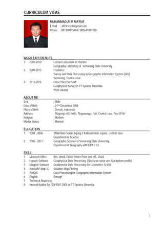
- 1. CURRICULUM VITAE MUHAMMAD AFIF MA'RUF Email : afif.first.24@gmail.com Phone : 081390815864 / 085641883290 WORK EXPERIENCES 1. 2007-2010 Lecture's Assistant in Practice Geography Laboratory of Semarang State University 2. 2009-2012 Freelance Survey and Data Processing in Geographic Information System (GIS) Semarang, Central Java 3. 2012-2016 Data Processor Staff Geophysical Survey in PT Spektra Dinamika West Jakarta ABOUT ME Sex : Male Date of Birth : 24TH December 1988 Place of Birth : Demak, Indonesia Address : Tlogorejo rt03 rw03, Tlogowungu, Pati, Central Java, Pos 59161 Religion : Moslem Marital Status : Married EDUCATION 1. 2003 - 2006 SMA Islam Sultan Agung 2 Kalinyamatan Jepara, Central Java Department of Science 2. 2006 - 2011 Geographic Science of Semarang State University Department of Geography with GPA 3.43 SKILL 1. Microsoft Office (Ms. Word, Excel, Power Point and MS. Visio) 2. Hypack Software Geophysical Data Processing (Side scan sonar and Sub bottom profile) 3. Magpick Software Gradiometer Data Processing for Geometrics G-858 4. AutoMAP Map 3D Situation Map Plotting 5. ArcGIS Data Processing for Geographic Information System 6. English Enough 7. Technical Reporting 8. Internal Auditor for ISO 9001:2008 at PT Spektra Dinamika. 1
- 2. CURRICULUM VITAE COURSES / TRAINING 1. October 2015 Basic Sea Survival Training. By PT. Indosafe Pratama, Jakarta 2. October 2012 Helicopter Under water Escape Training (HUET) & Basic Sea Survival Training. By PT. Indosafe Pratama, Jakarta. 3. October 2012 Mini Seminar for Introducing Hypack 2012 Software By PT. Geotindo Mitra kencana, Jakarta. LIST OF WORK EXPERIENCES 1. PT. BOSKALIS INTERNATIONAL INDONESIA - MAKASSAR STRAIT. Site Investigation Campaign For Center Point Of Indonesia (COI) Project KSO Ciputra Yasmin, Makassar Strait, Ujung Pandang, Indonesia (2-13 November 2015). Equipments : Sub-Bottom Profiler - Innomar SES-2000 Compact and MKIII Single Beam Echo sounder 2. PT. PENGERUKAN INDONESIA (RUKINDO) - PORT of BANTEN. Sub Bottom Profile (SBP) Survey (24 October 2015). Equipments : Sub-Bottom Profiler - Edge Tech SB-216S and SyQwest Single Beam Echo sounder. 3. PT PERTAMINA PERSERO - JAKARTA. Topographic Survey and Utilities Simprug and Pondok Ranji Area (October 2015). 4. TOTAL E&P INDONESIE - BALIKPAPAN, EAST KALIMANTAN. a) Geophysical Survey For Inshore and Near shore - (April - December 2014). Responsibility : Geophysical Data Processor & Technical Report. b) Topography Survey For Onshore Export Pipeline as Built - ( January - December 2013). Responsibility : Survey & Data Processor for Gradiometer G-858. c) Geophysical Survey For Inshore and Near shore - (October 2011 - Mart 2012). Responsibility : GIS Data Processor. 5. PERUSAHAAN LISTRIK NEGARA (PLN) - MALACCA STRAIT Sumatera-Peninsular Malaysia HVDC Interconnection (Seabed Survey in Straits of Malacca) - (November 2013 - April 2014). Responsibility : Geophysical Data Processor & Technical Report. 6. LEMBAGA AFILIASI PENELITIAN DAN INDUSTRI (LAPI) Sub Bottom Profile (SBP) Survey (19-23 December 2012). Equipment : Sub-Bottom Profiler - Edge Tech SB-216S 7. PT. NAUTIC MARITIME SALVAGE - NUNUKAN, NORTH KALIMANTAN. Responsibility : Geophysical Data Processor (August - September 2012). 8. GIS OPERATOR - FREELANCE (2009 - 2011) - SEMARANG, CENTRAL JAVA 2