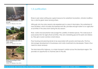
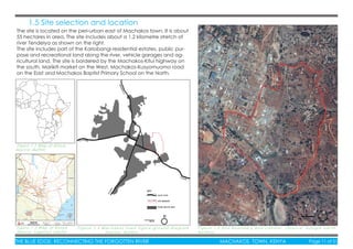
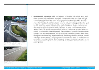
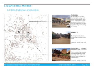
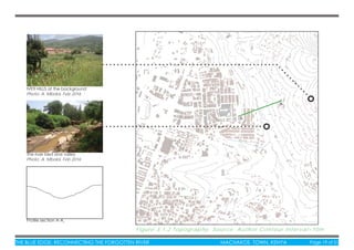
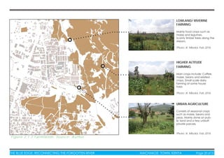
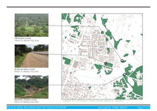
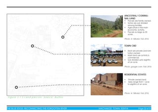
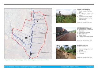
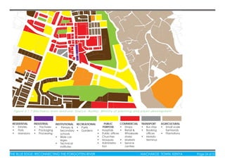
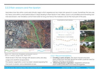
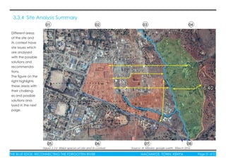
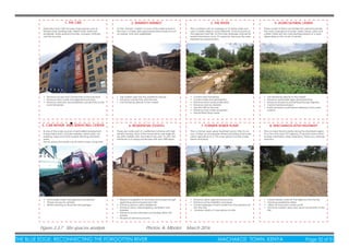
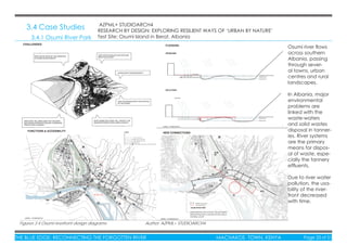
This document is a project report for reconnecting the forgotten river Tendelya in Machakos Town, Kenya. It provides background on Machakos Town and identifies problems affecting the river such as pollution, erosion, and unsustainable sand harvesting. The report justifies the need to revitalize the river and its riparian area to improve connectivity between the urban and rural landscapes. It outlines objectives to enhance river remediation, stormwater management, and sustainable agriculture. A literature review covers impacts of human activities on rivers like deforestation, impervious surfaces, and sediment disturbance. The report will inform a design project to create an interactive peri-urban waterfront with mutual benefits for the urban and rural communities.
The Circuit: Building Trails that Connect Cities, Suburbs, and Everywhere In Between
Abstract: This session will discuss how the Circuit Coalition is using advocacy, communications and planning to realize the vision of a 750 mile multi-use trail network connecting Greater Philadelphia.
Presenters:
Presenter: Sarah Stuart Bicycle Coalition of Greater Philadelphia
Co-Presenter: Jacob Gordon Cooper's Ferry Partnership
Co-Presenter: Patrick Starr Pennsylvania Environmental Council
This document presents a vision to revitalize a 53-mile stretch of the Chattahoochee River that runs through the Atlanta region. It proposes creating a 5,000-acre "working park" along the riverfront comprised of interconnected farms, forests, parks and nature preserves. It outlines both long-term goals of expanding access to the riverfront and improving stewardship of the river and surrounding lands, as well as near-term goals such as creating 20 new ways for people to access, experience and tell the stories of the riverfront. Maps show potential areas for new parks, trails and other projects to connect communities to the riverfront. The vision is for the riverfront to become a vibrant natural resource for recreation
Presentation by Metro Vancouver Parks Committee chair Gayle Martin to Langley (BC) Township Council on MV's Experience the Fraser trail and park plan. July 20, 2009.
This document summarizes Sheryl Stohs' environmental portfolio and interests. It discusses her background working on issues like protecting waters, climate change, and toxic substances elimination. It also outlines a study she conducted on landscape changes in Newell Creek Canyon through interviews with local pioneers. The study aimed to identify historical events connected to social land use changes that could inform watershed assessment and management. Key themes from the interviews included transportation following waterways and the cultural influences shaping current and future land use patterns.
The document provides an overview of the public process used to develop the Blueprint Jordan River vision. It involved workshops, focus groups, online surveys, and map analysis with over 1,000 community members. The key findings were that the public strongly supported a "green corridor" vision for the river with large natural buffers, habitat preservation, and multi-use trails for walking, biking, and other non-motorized recreation. Nature preserves and wildlife viewing areas were particularly important in the community's vision for the future of the Jordan River corridor.
The document summarizes the 2015 Annual Trails Report from the Pennsylvania Trails Advisory Committee. It highlights that 29 trail grant projects were completed totaling $7.8 million, and 67 new projects were awarded $7.2 million. It also announces that the Heritage Rail Trail County Park in York County was selected as the 2015 Trail of the Year for providing nearby outdoor opportunities and linking to regional history and trails.
El documento describe los 14 pasos para instalar FreeBSD, incluyendo asignar memoria RAM, crear un disco virtual, seleccionar el tipo de archivo ISO, iniciar la instalación mediante el boot, y completar la instalación introduciendo el nombre de usuario y seleccionando el código fuente del sistema.
This Woman Saved Money By Eating Foods in Alphabetical Order _ MUNCHIESJack Rushall
This woman saved money by eating foods in alphabetical order for one year. She would eat only foods starting with the current letter of the alphabet for two week periods. This limited her options but also led her to cook in bulk and rely on leftovers. It was primarily done for fun, but she did save some money unintentionally. She socialized more by seeking out activities and friends corresponding to each letter. Her cafe held parties to celebrate completing each letter.
1. Se elige Archlinux como sistema operativo en VirtualBox, se asigna la memoria RAM de forma dinámica y se crea un disco duro virtual.
2. Se busca la imagen ISO de Archlinux y se inicia la instalación del sistema operativo.
3. Una vez terminada la instalación, aparece el shell del nuevo sistema operativo Archlinux instalado en VirtualBox.
Este documento habla sobre tres tecnologías de la información: Blogger, que es una plataforma para crear blogs donde se publican artículos diariamente; Slideshare, que permite a los usuarios subir presentaciones como PowerPoint y PDF; y Web 2.0, que permite a los usuarios crear, compartir, gestionar y modificar contenidos en la web.
La norma ISO 31000 establece principios y directrices para una efectiva gestión de riesgos. Provee un marco de trabajo y proceso para identificar, analizar y tratar riesgos de una manera sistemática y transparente. El estándar ayuda a organizaciones de todo tipo y tamaño a mejorar la toma de decisiones, lograr objetivos y aumentar la confianza de los interesados manejando riesgos de forma proactiva.
El documento proporciona instrucciones para instalar Android 6.0 en una máquina virtual, incluyendo crear la máquina virtual, seleccionar la imagen ISO de Android, realizar la instalación, configurar la partición, reiniciar el sistema y completar la configuración inicial.
Este documento habla sobre tres tecnologías de la información: Blogger, que es una plataforma para crear blogs donde se publican artículos diariamente; Slideshare, que aloja presentaciones de PowerPoint, PDF y otros formatos subidos por usuarios; y Web 2.0, que permite a los usuarios crear, compartir, gestionar y modificar contenidos en la web.
“Using Video to enhance the Project Communication Processes”Steve Fowler
Video is an extremely effective communication media and when properly crafted, projects to the intended audience a clear and concise message much more efficiently than via words or descriptions. Creating an effective video is a project requiring detailed planning, requirements collection, scheduling, team communications, storyboards, quality controls and much more familiar to the PM. Learn how you as a PM can use video to better communicate with your stakeholders and increase the project’s acceptance by end users.
*Note this SlideShare contains links to sample video clips hosted on a private video hosting site.
Este documento describe los diferentes tipos de memorias en una computadora, incluyendo la memoria RAM, ROM, SRAM, y virtual. Explica que la memoria RAM almacena datos e instrucciones de forma temporal, mientras que la ROM almacena datos de forma permanente. Además, detalla la jerarquía de almacenamiento desde la memoria primaria hasta la terciaria.
El periodismo digital designa la modalidad del periodismo que tiene a Internet como entorno principal de desarrollo. Se refiere a la especialidad del periodismo que emplea el ciberespacio para investigar, producir y difundir contenidos periodísticos. Esta modalidad surgió del desarrollo de las nuevas tecnologías desde finales del siglo XX, permitiendo que medios como la radio, la televisión y la prensa incursionen en Internet y las redes digitales.
Este documento presenta tres tipos de materiales de capacitación para cursos de gestión en redes de establecimientos y servicios de salud: 1) Un texto autoinstruccional que introduce los temas de gestión, 2) Una guía para diseñar trabajos aplicativos en el propio establecimiento, y 3) Un texto de apoyo con lecturas recomendadas. El objetivo es mejorar la capacidad de gestión de los establecimientos para lograr una atención de salud con calidad, equidad y eficiencia.
Wonder Woman is a strong and powerful female superhero. She has super strength, speed, agility, and can fly. She received her powers from the Greek gods and was originally made from clay by her mother Queen Hippolyta. Wonder Woman has numerous abilities including super strength, the power to communicate telepathically with soldiers, and she possesses an invisible jet.
Las Normas ISO 9000 son un conjunto de estándares que especifican los elementos que deben incluir los sistemas de gestión de calidad de las organizaciones y cómo deben funcionar estos elementos para garantizar la calidad de los productos y servicios. Las Normas ISO 9000 son desarrolladas por la Organización Internacional de Normalización y establecen requisitos mínimos que los sistemas de gestión de calidad deben cumplir.
Student collaborative project presentation - a body of strategies for improving he City of Syracuse - (Produced for ARC 500 Ecology of Cities; Prof. Lina Vassilev)
Daylighting the Amorsolo Creek - Participatory Design and the Revival of an U...Rodelon Ramos
Daylighting the Amorsolo Creek - Participatory Design and the Revival of an Urban Waterway in Makati CBD
Author: Rodelon Ramos, Master of Architecture, University of the Philippines Diliman
The strategies included creating large pedestrian zones along lake edge, developing on outer road by strengthening existing road network, creating approximately 2 km of access streets as
well as new access point of lake front enhancing recreational potential by improving public facilities and encouraging overall development within the precinct.
This document discusses riverfront development and landscape architecture. It begins with definitions of key terms like riverfront and waterfront public space. It then discusses the characteristics and types of riverfronts, as well as the advantages of riverfront development projects. Principles, criteria and case studies of successful riverfront projects are provided. The case study focuses on the Kutchin Riverfront development in Malaysia, which transformed a commercial river area into a recreational space with amenities while celebrating the local culture and history.
Coastal Green Infrastructure for Westchester Creek_small IVMarcel Negret
This document provides an overview and analysis of coastal green infrastructure opportunities for Westchester Creek in the Bronx. It begins with background on the degraded environmental conditions and increasing flood risks facing the creek. The author then outlines their project framework, which includes working with local groups to understand concerns and empower community participation in water management plans. Through physical surveys and interviews, the author assesses existing creek conditions and regulatory plans. The document then defines coastal green infrastructure and reviews case studies of its use for flood mitigation and water quality improvement. Finally, the author proposes implementing coastal green infrastructure at Westchester Creek to address flooding and pollution, with the goal of informing and engaging local stakeholders in the decision-making process.
Riverfront Development & Haat Case StudyAMIT ANAND
Aim - “Conserve, Protect & Restore the Biodiversity of Yamuna integrated with Public Recreation spaces that the city needs as envisaged in the Zonal Development of Zone O”.
Masters thesis - Urban renewal of Historic core- Case of Varanasi (Ongoing).pdfDeep Gupta
The document discusses a thesis presented by Deep Prakash on conservation and urban renewal as a base for sustainable development in historic cities, using Varanasi as a case study. It begins by outlining the deterioration of historic core areas in rapidly developing cities and the need to integrate cultural heritage, development planning, and local economies. It then discusses issues facing Varanasi's built heritage, degraded housing environments, sanitation problems, and lack of effective heritage management institutions. The thesis aims to delineate Varanasi's heritage areas and suggest policies and regulations to revitalize the old city while preserving its traditional identity and improving living conditions.
THE USE OF METHANE GAS HARVESTED FROM WASTE AS A BENEFICIAL RESOURCE TO THE S...Yoofi Ansah
The document discusses waste management practices in the Sakumono community in Ghana and advanced countries. In the Sakumono community, waste is collected but then dumped in landfills without sorting or processing. This is resulting in landfills filling up more quickly. In contrast, in advanced countries, waste is sorted into materials like paper, metal, plastic and glass after collection. These materials are then processed and can be used as resources. The document proposes harvesting methane gas from waste in the Sakumono community as was done in advanced countries to provide a beneficial resource for the community.
This document provides a summary of Sunchung Christine Min's architectural works and thesis project. It includes:
1) A brief description of her thesis project "Modus Vivendi" which proposed an ecological intervention in the Korean DMZ as a prototype facility.
2) Summaries of 5 other projects she worked on from 2010-2011 including a comprehensive design studio, public plaza, studio projects, and office work.
3) Floor plans and diagrams from her thesis project showing the layout and sustainable design strategies of the proposed ecological center.
Riverfront Development- A tool to Improve and restore urban green spacesIRJET Journal
This document discusses riverfront development as a tool to improve urban green spaces. It focuses on developing the riverfront areas in the west and southwest zones of Surat City, India. The objectives are to study the existing riverfront scenario, improve the quality of urban areas and riverfront neighborhoods, safeguard future green spaces, and create public spaces and amenities for sociocultural life through a master plan for riverfront development. Issues with the current development include poor communities living along the riverbanks in inadequate housing that floods, and industrial and domestic waste polluting the river.
Carrie Furnace is a abandoned iron furnace that helped revolutionize Pittsburgh during the Steel Era. Today, the brownfield site exists as a void in the urban fabric.
The Monongahela River once thrived as an industrial corridor. The fall of the steel industry left the river corridor empty, polluted, and disconnected from local communities. The resurgence of public space along the Monongahela River provides vast opportunities for the city of Pittsburgh and those living in adjacent communities. The concept of this master plan will bring life back to the riverfront and reestablish connections to the river, the local communities, and the rich industrial history of the site. The mixed-use development will seamlessly integrate economic, recreational, ecological, and historical uses.
The document proposes a project to connect the city of Veracruz, Mexico by redeveloping an existing rail yard. The project aims to achieve connectivity and environmental sustainability. It would create pedestrian paths and public spaces for social interaction around the rail yard while keeping the rail yard intact for freight transport. Elements like solar panels, local materials, and educational campaigns would promote environmental sustainability. The soil in the rail yard would be cleaned and purified. The redeveloped area would include places for community gathering, digital connectivity features, educational and cultural spaces, walking and bike paths, and use of local flora.
Río Urbano is a citizen initiative in Costa Rica that aims to create a cultural change towards urban rivers through community engagement. It conducts research, urban design, and cultural interventions including participatory art, guided walks, talks and collaborative projects. The goal is to make rivers visible again, promote environmental regeneration, and foster a positive river culture and identity by involving local communities.
IRJET- Water Imprints: The Process of Contemporary Urbanization for [Re]-Stru...IRJET Journal
This document discusses the process of urbanization in Dhaka, Bangladesh and how it has impacted the relationship between urban and rural areas. It notes that rapid urban growth has physically separated cities from natural resources like water and open spaces. The lack of connection between urban and environmental areas has exacerbated water crises and degraded the land. The document argues that water can be a sustainable element to reconnect cities to surrounding territories if it is incorporated into the spatial structure of urban planning. It examines theories of regionalism, environmentalism, and transects - the grading of habitats from rural to urban. Integrating ecological elements like water and green spaces into urban planning could make cities and their surrounding areas more livable while regenerating the relationship between urban
Kathryn Little's portfolio document summarizes several of her architectural projects from her time in school. It includes summaries of 7 different projects she worked on, with details on the location, timeframe, and goals of each project. The document provides floor plans, sections, and renderings to illustrate her designs.
This document presents a student's report on their proposed future city called the "Underwater Spider Web City". It begins with an introduction providing context for the assignment as designing a new layout for the city of "X" due to it becoming unlivable. It then reviews the definitions and history of cities before analyzing examples of ancient cities like Thonis-Heracleion and Babylon to identify design elements that could be applied to an underwater city. Examples of present cities like Singapore are also investigated for relevant infrastructure. The document proposes an "Underwater Spider Web City" as the new design for city "X" and will continue to outline the process, progress and conclusion of the project.
This Slideshare presentation details what RiverLink is all about, offering information on our The Wilma Dykeman RiverWay Plan, our educational outreach, our water quality efforts and our recreational outreach, including the French Broad River Paddle Trail and our festivals. Get to know us and you'll love our work.
1. T H E B L U E E D G E
R E C O N N E C T I N G T H E F O R G O TT E N R I V E R
-EASTERN MACHAKOS TOWN, KENYA-
APRIL 2016
J O M O K E N Y A T T A U N I V E R S I T Y O F A G R I C U L T U R E A N D T E C H N O L O G Y
D E P A R T M E N T O F L A N D S C A P E A R C HI T E C T U R E
MBOLOI ANDREW KIOKO
AB242-1340/2012
PROJECT
REPORT
2. THE BLUE EDGE: RECONNECTING THE FORGOTTEN RIVER MACHAKOS TOWN, KENYA Page ii of 51
I wish to express my appreciation to all those who have contributed in one way or another in the pro-
cess of research and design of this project and project report. To the J.K.U.A.T. fraternity; the Depart-
ment of Landscape Architecture for granting me an opportunity to study Landscape Architecture, to
the university library, for provision of reference material during my study. To my supervisors and lectur-
ers, thank you for your guidance. To the department of planning and urban development in Macha-
kos county, for provision of site information and relevant documents. I also benefited greatly from a
supporting cast of knowledgeable fellow students, thank you for being great classmates.
Finally special thanks to my family for the spiritual, moral and financial support through my under-
graduate education, you will forever be treasured.
Acknowledgements
3. THE BLUE EDGE: RECONNECTING THE FORGOTTEN RIVER MACHAKOS TOWN, KENYA Page iii of 51THE BLUE EDGE: RECONNECTING THE FORGOTTEN RIVER MACHAKOS TOWN, KENYA Page iii of 51
Waterways are a vital and productive resource to our environment. Rivers provide a variety of amen-
ities and services to communities across the world such as drinking water, food, travel, recreation,
wildlife habitat, connection to place, aesthetic appeal, economic development, among others.
Population increase, urbanization and evolution of human activities has led to increased demand
for ecosystem goods and services. Riverine landscapes, including river Tendelya in Machakos, have
suffered uncontrolled exploitation of these goods and services. This is may be due to the fact that
the river is community owned and not belonging to an individual, hence being a victim of tragedy
of the commons.
This design project examines the importance of the river Tendelya and its watershed to its urban and
rural community and how riverfront design can function as a unifying element for Machakos town,
river Tendelya and the immediate peri-urban zone.
Over half of the world’s future population will be living in urban environments by 2030, which will
dramatically increase the stress on a vulnerable network of water systems. A restoration of a river can
bring awareness to people while improving physical and ecological corridor connections (Bernhardt
& Palmer, 2007).
Abstract
4. THE BLUE EDGE: RECONNECTING THE FORGOTTEN RIVER MACHAKOS TOWN, KENYA Page iv of 51
Before I joined upper primary school, we lived in the countryside of a rural com-
munity near a small seasonal river. I spent most of my childhood afternoons out-
doors since in lower primary school, classes ended at midday. We had many
memorable activities with my friends along the river, including swimming in the
then clean waters. It hadn’t occurred to me at the time how truly connected I
was to the river’s ecological setting until I began living in an urban environment
and attending boarding schools.
In many urban cities there is little connection between the ecology
of a river and its urban dwellers. Many urban settings include built
infrastructure with poor connections to natural elements and/or paying little
attention to the river.
Why is there a missing connection between the river and its urban setting?
Is it because cities have turned their back away from the river? How can
landscape architecture help urban communities reconnect to a river?
Narrative
5. THE BLUE EDGE: RECONNECTING THE FORGOTTEN RIVER MACHAKOS TOWN, KENYA Page v of 51THE BLUE EDGE: RECONNECTING THE FORGOTTEN RIVER MACHAKOS TOWN, KENYA Page v of 51
Table of content
Acknowledgements........................................................................................................................ ii
Abstract ............................................................................................................................................iii
Narrative...........................................................................................................................................iv
Table of content..............................................................................................................................v
1. Chapter ONE: Introduction ........................................................................................................7
1.1 Background to study.................................................................................................................7
1.2 Problem Statement ...................................................................................................................8
1.3 Justification.................................................................................................................................9
1.4 Project Objectives....................................................................................................................10
1.4.1 Ultimate Objective ................................................................................................................10
1.4.2 Immediate Objectives ..........................................................................................................10
1.5 Site selection and location......................................................................................................11
2. CHAPTER TWO: LITERATURE REVIEW ..........................................................................................12
2.1 Human interference on rivers..................................................................................................12
2.2 The Hydrological cycle ............................................................................................................14
2.3 Storm-water management .....................................................................................................15
2.3.1 Approaches to Storm-water Management.......................................................................16
3. CHAPTER THREE: METHODS ........................................................................................................18
3.1 Data Collection and Analysis..................................................................................................18
3.2 Client Brief Development and Analysis..................................................................................25
3.3 Site Analysis ...............................................................................................................................28
3.3.3 Rain seasons and the riparian..............................................................................................30
3.3.4 Site Analysis Summary ..........................................................................................................31
3.4 Case Studies..............................................................................................................................33
6. THE BLUE EDGE: RECONNECTING THE FORGOTTEN RIVER MACHAKOS TOWN, KENYA Page vi of 51
4. Chapter FOUR: Conclusions & Recommendations................................................................35
4.1 Opportunities ............................................................................................................................35
4.1.1 Machakos-Kitui highway ......................................................................................................35
4.1.2 Riverfront recreation and activities .....................................................................................35
4.1.3 Irrigation farming ...................................................................................................................36
4.1.4 Urban agriculture...................................................................................................................36
4.2 Constraints.................................................................................................................................37
4.2.1 Terrain/ steep slope...............................................................................................................37
4.2.2 Land ownership .....................................................................................................................37
5. Chapter FIVE: Design solutions..................................................................................................38
5.1 Philosophy .................................................................................................................................38
5.2 Concepts...................................................................................................................................39
6.1 Master plan ...............................................................................................................................40
6. Chapter SIX: Selected Drawings...............................................................................................40
6.2 Street scape character ..........................................................................................................41
6.3 Design strategies.......................................................................................................................42
6.4 Design strategies.......................................................................................................................43
6.5 Perspective views of selected spaces..................................................................................44
6.6 Perspective views of selected spaces.................................................................................45
6.7 Perspective views of selected spaces..................................................................................46
6.8 Perspective views of selected spaces.................................................................................47
6.9 Construction details .................................................................................................................48
6.10 Construction details ...............................................................................................................49
6.11 Cited works and Bibliography...............................................................................................50
6.12 Cited works and Bibliography...............................................................................................51
7. THE BLUE EDGE: RECONNECTING THE FORGOTTEN RIVER MACHAKOS TOWN, KENYA Page 7 of 51THE BLUE EDGE: RECONNECTING THE FORGOTTEN RIVER MACHAKOS TOWN, KENYA Page 7 of 51
Machakos Town, 64 kilometres southeast of Nairobi, was established in 1887 as the first ad-
ministrative centre for the new British East Africa colony, ten years before Nairobi came to
be. However, the British moved the capital to Nairobi in 1899 when Machakos fell too far
outside of the reach of the Uganda Railway that was then under construction.
As the capital of the Machakos County in Eastern Province of Kenya, Machakos Town is a
major rural centre, and also a satellite town due to its proximity to Nairobi. Its population is
rapidly growing and is 192,117 (as of 2009).
Machakos town mainly offers services such as Banking, government administration, educa-
tional, recreational, trade, sports and as a transport corridor junction. The rural neighbour-
hood, mainly acts as agricultural land with low density rural settlements.
The town is situated on a hilly neighbourhood, with the closest as Iveti hills in the East. This has
led to the ever expanding river streams and valleys within the neighbourhood.
1. CHAPTER ONE: INTRODUCTION
1.1 Background to study
8. THE BLUE EDGE: RECONNECTING THE FORGOTTEN RIVER MACHAKOS TOWN, KENYA Page 8 of 51
1.2 Problem Statement
Rivers are great resources for both the rural and the urban setting. River Tendelya, in Eastern
Machakos town, acts as the municipality boundary which hence, theoretically, separates
the rural and the urban.
Due to the mixed character in the rivers neighbourhood on either sides, the river has been
neglected and exploited unsustainably, with pollution, sand harvesting and riverbed and
bank erosion as the main problem.
The urban setting has on-site problems such as poor infrastructure, unplanned neighbour-
hoods, poor housing facilities and waste dumping which is the major source of the river
pollution. The town has also developed towards the western side with the eastern side being
neglected however it has riverfront, which is a great asset.
The ‘rural’, Eastern side of the river, faces challenges such as farmland erosion, water and soil
pollution from farm inputs, deforestation and lack of proper circulation routes.
The rural and the urban have a poor relationship in terms of circulation connectivity, product
and service dependency.
An eroded roadside on site.
Photo: A. Mboloi, Feb 2016
A dump-site on the streets of
downtown Machakos.
Photo: A. Mboloi, Feb 2016
Substandard housing in Kari-
obangi estate.
Photo: A. Mboloi, Feb 2016
9. THE BLUE EDGE: RECONNECTING THE FORGOTTEN RIVER MACHAKOS TOWN, KENYA Page 9 of 51THE BLUE EDGE: RECONNECTING THE FORGOTTEN RIVER MACHAKOS TOWN, KENYA Page 9 of 51
1.3 Justification
Rivers in peri urban setting are a great resource for waterfront recreation, climate modifica-
tion, a site for great views among others.
Although only two rainy seasons are experienced in a year in Machakos, the watershed of
river Tendelya, which includes the forested Iveti hills, provides enough water to run agricultur-
al activities in the area even during the dry season.
River, water and soil pollution discourage the usability of related spaces. This is because of
poor production for agricultural activities, they are a breeding ground for pests and diseas-
es, they give a poor scenery a bad odours.
Poor housing and planning tends to be associated with poverty and insecurity. This thus
discourages development of businesses and costly investments by developers. There is thus
need for urban renewal.
The Machakos-Kitui highway, is a major transport corridor across the Ukambani region. This
provides an opportunity to channel users to the site.
Sand harvesting in river
Tendelya
Photo: A. Mboloi, Feb 2016
River Tendelya just after a
flash flood.
Photo: A. Mboloi, Feb 2016
An heavily polluted stream
on site.
Photo: A. Mboloi, Feb 2016
10. THE BLUE EDGE: RECONNECTING THE FORGOTTEN RIVER MACHAKOS TOWN, KENYA Page 10 of 51
1.4 Project Objectives
1.4.1 Ultimate Objective
The main objective of this project is to create an interactive peri-urban waterfront, with mu-
tual benefit between the urban and the rural region.
1.4.2 Immediate Objectives
• To provide measures to enhance river re-mediation and revitalization on problems such
as pollution, erosion and sand harvesting.
• To enhance site storm-water management and flash-flood management.
• To enhance physical and visual connectivity between Machakos town and river Tende-
lya.
• To propose measures on rain water harvesting and utilisation.
• Recommend measures to enhance sustainable agricultural activities on site and the im-
mediate neighbourhood.
• To give a proposal for riverfront spaces with diverse character to accommodate different
activities.
11. THE BLUE EDGE: RECONNECTING THE FORGOTTEN RIVER MACHAKOS TOWN, KENYA Page 11 of 51THE BLUE EDGE: RECONNECTING THE FORGOTTEN RIVER MACHAKOS TOWN, KENYA Page 11 of 51
Figure 1.2 Map of Africa,
Source: Author
Figure 1.3 Map of Kenya
Source: Logistics cluster
F i g u r e 1 . 4 M a c h a k o s t o w n f i g u r e - g r o u n d d i a g r a m
S o u r c e : A u t h o r
F i g u r e 1 . 5 S i t e b o u n d a r y a n d c o n t e x t ( S o u r c e ; G o o g l e e a r t h ,
A u t h o r )
1.5 Site selection and location
The site is located on the peri-urban east of Machakos town. It is about
55 hectares in area. The site includes about a 1.2 kilometre stretch of
river Tendelya as shown on the right.
The site includes part of the Kariobangi residential estates, public pur-
pose and recreational land along the river, vehicle garages and ag-
ricultural land. The site is bordered by the Machakos-Kitui highway on
the south, Marikiti market on the West, Machakos-Kusyomuomo road
on the East and Machakos Baptist Primary School on the North.
12. THE BLUE EDGE: RECONNECTING THE FORGOTTEN RIVER MACHAKOS TOWN, KENYA Page 12 of 51
2. CHAPTER TWO: LITERATURE REVIEW
Human-induced land-use changes can have a significant effect on a stream’s mor-
phology. Deforestation, urbanization, agricultural practices and wetland conversion
can all contribute to stream channel degradation (Hammer 1972; Knox 1977; Hooke
1994).
Impervious surfaces are one of the many human fabrications that disrupt hydrologi-
cal processes. Impervious surfaces are simply substances that halt the penetration of
water into the soil. The result of this barrier is increased runoff, higher stream channel
velocities and greater flooding (Arnold and Gibbons 1996; Wolman 1967). Catch-
ments with 10-20 percent imperviousness can have increases in peak flows up to
two-to-three times the normal discharge (Booth 1990). However, watershed-specific
variables such as bed and bank material, riparian condition, ultimately play a role in
the severity of 10 imperviousness (Bledsoe and Watson 2001).
Banks with cleared riparian corridors will degrade faster than those with vegetation
left intact. Likewise riparian soils with high clay contents will be more resistant to ero-
sion than soils with high sand and silt content (Smerdon and Beasley 1959).
2.1 Human interference on rivers
13. THE BLUE EDGE: RECONNECTING THE FORGOTTEN RIVER MACHAKOS TOWN, KENYA Page 13 of 51THE BLUE EDGE: RECONNECTING THE FORGOTTEN RIVER MACHAKOS TOWN, KENYA Page 13 of 51
Hydrological changes in form of increased runoff and erosion occur when lands are
converted from forest or prairie into agricultural usage (Krug 1996). Increased runoff is
often a product of vegetation removal and improper grazing methods since vegeta-
tion plays an important role in slowing runoff and in the absorption of rainfall. Further
detrimental effects such as erosion and habitat destruction occur when livestock are
allowed unrestricted access to riparian buffers (Magilligan and McDowell 1997).
Human-induced changes also contribute to bed sediment disturbance. Agriculture,
urbanization, and timber operations can cause large amounts of sediment to be
delivered into fluvial systems (Hooke 1994).
Excessive rates of gravel deposition and events related to transport or ―gravel
waves, are one notable result of this disturbance. Channels often become sediment
storage places of gravel between high discharge events. Rather than being depos-
ited on overbank locations, sediment moves in episodic events and disrupts channel
form in the new location of deposition (Jacobson 1999).
14. THE BLUE EDGE: RECONNECTING THE FORGOTTEN RIVER MACHAKOS TOWN, KENYA Page 14 of 51
2.2 The Hydrological cycle
Heating of the ocean water by the sun is the key process that keeps the hydrologi-
cal cycle in motion. Water evaporates, then falls as precipitation in the form of rain,
hail, snow, sleet, drizzle or fog. On its way to Earth some precipitation may evapo-
rate or, when it falls over land, be intercepted by vegetation before reaching the
ground. The cycle continues in three different ways:
• Evaporation/transpiration – On average, as much as 40 percent of precipitation
is evaporated or transpired.
• Percolation into the ground – Water moves downward through cracks and pores
in soil and rocks to the water table. Water can move back up by capillary action
or it can move vertically or horizontally under the earth’s surface until it re-enters
a surface water system.
• Surface runoff – Water runs overland into nearby streams and lakes; the steep-
er the land and the less porous the soil, the greater the runoff. Overland flow is
particularly visible in urban areas. Rivers join each other and eventually form one
major river that carries all of the sub-basins’ runoff into the ocean.
Although the hydrological cycle balances what goes up with what comes down,
one phase of the cycle is “frozen” in the colder regions during the winter season.
During winter, for example, most of the precipitation is simply stored as snow or ice
on the ground. Later, during the spring melt, huge quantities of water are released
quickly, which results in heavy spring runoff and flooding.
Figure 2.2 Hydrological processes;
Source: www.metoffice.gov.uk;
19th April 2016
Figure 2.1 Hydrological processes;
Source: www.h2odistributors.com;
19th April 2016
15. THE BLUE EDGE: RECONNECTING THE FORGOTTEN RIVER MACHAKOS TOWN, KENYA Page 15 of 51THE BLUE EDGE: RECONNECTING THE FORGOTTEN RIVER MACHAKOS TOWN, KENYA Page 15 of 51
2.3 Storm-water management
Storm-water runoff occurs when precipitation from rain or snow-melt flows over the
land surface. The addition of roads, driveways, parking lots, rooftops and other sur-
faces that prevent water from soaking into the ground to our landscape greatly
increases the runoff volume created during storms. This runoff is swiftly carried to our
local streams, lakes, wetlands and rivers and can cause flooding and erosion, and
wash away important habitat for critters that live in the stream.
Storm-water runoff also picks up and carries with it many different pollutants that are
found on paved surfaces such as sediment, nitrogen, phosphorus, bacteria, oil and
grease, trash, pesticides and metals. It comes as no surprise then that storm-water
runoff is the number one cause of stream impairment in urban areas.
To reduce the impacts of runoff on urban streams, EPA expanded the Clean Water
Act in 1987 to require municipalities to obtain permits for discharges of storm-water
runoff. As a result, many communities have adopted regulations requiring develop-
ers to install storm-water management practices that reduce the rate and/or volume
and remove pollutants from runoff generated on their development sites.
16. THE BLUE EDGE: RECONNECTING THE FORGOTTEN RIVER MACHAKOS TOWN, KENYA Page 16 of 51
• Low-Impact Development (LID) is a storm-water management approach that
seeks to manage runoff using distributed and decentralized micro-scale controls.
LID’s goal is to mimic a site’s predevelopment hydrology by using design tech-
niques that infiltrate, filter, store, evaporate, and detain runoff close to its source.
Instead of conveying and treating storm-water solely in large end-of-pipe facili-
ties located at the bottom of drainage areas, LID addresses storm-water through
small-scale landscape practices and design approaches that preserve natural
drainage features and patterns. Several elements of LID—such as preserving
natural drainage and landscape features—fit right into the Green Infrastructure
approach described below.
• Green Infrastructure refers to natural systems that capture, cleanse and reduce
storm-water runoff using plants, soils and microbes. On the regional scale, green
infrastructure consists of the interconnected network of open spaces and nat-
ural areas (such as forested areas, floodplains and wetlands) that improve wa-
ter quality while providing recreational opportunities, wildlife habitat, air quality
and urban heat island benefits, and other community benefits. At the site scale,
green infrastructure consists of site-specific management practices (such as in-
terconnected natural areas) that are designed to maintain natural hydrological
functions by absorbing and infiltrating precipitation where it falls.
2.3.1 Approaches to Storm-water Management
Figure 2.3: Vegetated swale in Portland, OR.
Photo: A. Omlid.
Figure 2.4: Flow-through planter in Eugene, OR.
Photo: A. Omlid.
17. THE BLUE EDGE: RECONNECTING THE FORGOTTEN RIVER MACHAKOS TOWN, KENYA Page 17 of 51THE BLUE EDGE: RECONNECTING THE FORGOTTEN RIVER MACHAKOS TOWN, KENYA Page 17 of 51
• Environmental Site Design (ESD), also referred to as Better Site Design (BSD), is an
effort to mimic natural systems along the whole storm-water flow path through
combined application of a series of design principles throughout the develop-
ment site. The objective is to replicate forest or natural hydrology and water qual-
ity. ESD practices are considered at the earliest stages of design, implemented
during construction and sustained in the future as a low maintenance natural
system. Each ESD practice incrementally reduces the volume of storm-water on
its way to the stream, thereby reducing the amount of conventional storm-water
infrastructure required. Example practices include preserving natural areas, mini-
mizing and disconnecting impervious cover, minimizing land disturbance, conser-
vation (or cluster) design, using vegetated channels and areas to treat storm-wa-
ter, and incorporating transit, shared parking, and bicycle facilities to allow lower
parking ratios.
Figure 2.5: Curb-cut to direct storm-water into
planter in Portland, OR. Photo: A.Omlid.
Figure 2.6: Permeable paving blocks in Portland,
OR. Photo: A.Omlid.
18. THE BLUE EDGE: RECONNECTING THE FORGOTTEN RIVER MACHAKOS TOWN, KENYA Page 18 of 51
3. CHAPTER THREE: METHODS
3.1 Data Collection and Analysis
Figure 3.1.1 Built-up area: Source: Author
THE CBD
Buildings house facilities
such as; a shopping mall,
banks supermarkets, retail
shops, administrative offic-
es, parastatal and private
offices, hotels and accom-
modation. Highest building
is 10 floors
RESIDENTIAL ESTATES
This is mainly a high density
residential area. Buildings
are single story, both per-
manent and semi-perma-
nent housing.
Photo: A. Mboloi, Feb 2016
MARKETS
Buildings include; shops,
retail stalls, semi-permanent
stalls.
Photo: A. Mboloi, Feb 2016
19. THE BLUE EDGE: RECONNECTING THE FORGOTTEN RIVER MACHAKOS TOWN, KENYA Page 19 of 51THE BLUE EDGE: RECONNECTING THE FORGOTTEN RIVER MACHAKOS TOWN, KENYA Page 19 of 51
Figure 3.1.2 Topography; Source: Author Contour Interval=10m
IVETI HILLS at the background
Photo: A. Mboloi, Feb 2016
The river bed and valley
Photo: A. Mboloi, Feb 2016
Profile section A-A1
A
A1
20. THE BLUE EDGE: RECONNECTING THE FORGOTTEN RIVER MACHAKOS TOWN, KENYA Page 20 of 51
Figure 3.1.3 Farmlands: Source: Author
LOWLAND/ RIVERINE
FARMING
Mainly food crops such as
maize and legumes.
Scanty timber trees along the
stream.
Photo: A. Mboloi, Feb 2016
HIGHER ALTITUDE
FARMING
Main crops include; Coffee,
maize, beans and related
crops. Small scale dairy
farming at some house
hold.
Photo: A. Mboloi, Feb 2016
URBAN AGRICULTURE
Consists of seasonal crops
such as maize, beans and
peas. Mainly done on pub-
lic land and a few unbuilt
private parcels.
Photo: A. Mboloi, Feb 2016
21. THE BLUE EDGE: RECONNECTING THE FORGOTTEN RIVER MACHAKOS TOWN, KENYA Page 21 of 51THE BLUE EDGE: RECONNECTING THE FORGOTTEN RIVER MACHAKOS TOWN, KENYA Page 21 of 51
Figure 3.1.4 Forest/ Tree cover Source: Author
Hill forest cover
Photo: A. Mboloi, Feb 2016
Avenue tree cover
Photo: A. Mboloi, Feb 2016
Riparian forest cover
Photo: A. Mboloi, Feb 2016
22. THE BLUE EDGE: RECONNECTING THE FORGOTTEN RIVER MACHAKOS TOWN, KENYA Page 22 of 51
Figure 3.1.5 Land parcels: Source: Author
ANCESTRAL/ COMMU-
NAL LAND
• Parcels are family owned.
• Some are sub divided
among families.
• Agriculture is the main
economic activity.
• Parcels as large as 20
acres .
Photo: A. Mboloi, Feb 2016
RESIDENTIAL ESTATES
• Private owned land.
• Sizes range from 1 acre
to eighths of an acre.
Photo: A. Mboloi, Feb 2016
TOWN CBD
• Most are private and insti-
tution owned.
• Main land use activity is
commercial.
• Sub divided upto eighths
of an acre.
Photo: google.com, Feb 2016
23. THE BLUE EDGE: RECONNECTING THE FORGOTTEN RIVER MACHAKOS TOWN, KENYA Page 23 of 51THE BLUE EDGE: RECONNECTING THE FORGOTTEN RIVER MACHAKOS TOWN, KENYA Page 23 of 51
Figure 3.1.6 Hydrology and drainage: Source: Author
FARMLAND RUNOFF
• Major cause of soil ero-
sion
• Runoff is polluted by farm
inputs
• Carries much silt which
is deposited at the river
bed as sand.
Photo: A. Mboloi, Feb 2016
RIVER TENDELYA
• Main drainage channel
on site
• It’s seasonal
• Polluted
Photo: A. Mboloi, Feb 2016
ROADSIDE DRAINAGE
• Mainly drains runoff from
the road
• Concrete channels
• Polluted water
• Open drains
• May contain solid waste
Photo: A. Mboloi, Feb 2016
24. THE BLUE EDGE: RECONNECTING THE FORGOTTEN RIVER MACHAKOS TOWN, KENYA Page 24 of 51
RESIDENTIAL
• Estates
• Flats
• Mansions
INDUSTRIAL
• Factories
• Packaging
• Processing
INSTITUTIONAL
• Primary &
Secondary
schools
• Bible col-
leges
• Technical
institutes
RECREATIONAL
• Parks
• Gardens
PUBLIC
PURPOSE
• Hospitals
• Public offices
• Churches
• Mosques
• Administra-
tion
COMMERCIAL
• Shops
• Retail &
Wholesale
stores
• Markets
• Service
centres
TRANSPORT
• Bus stop
• Booking
offices
• Matatu
terminus
AGRICULTURAL
• Small scale
farmlands
• Plantations
Figure 3.1.7 Machakos town land-use: Source: Author, Ministry of planning and urban development
25. THE BLUE EDGE: RECONNECTING THE FORGOTTEN RIVER MACHAKOS TOWN, KENYA Page 25 of 51THE BLUE EDGE: RECONNECTING THE FORGOTTEN RIVER MACHAKOS TOWN, KENYA Page 25 of 51
3.2 Client Brief Development and Analysis
From the observation made on site, several issues and spaces need to be addressed to meet people and environmental
needs. These spaces and facilities include; pedestrian and circulation routes, residential housing, commercial waterfront fa-
cilities, recreational facilities, agricultural lands, vegetation cover, river re-mediation and storm-water management facilities
and strategies and purpose facilities. The character of these spaces is discussed in the tables below.
26. THE BLUE EDGE: RECONNECTING THE FORGOTTEN RIVER MACHAKOS TOWN, KENYA Page 26 of 51
27. THE BLUE EDGE: RECONNECTING THE FORGOTTEN RIVER MACHAKOS TOWN, KENYA Page 27 of 51THE BLUE EDGE: RECONNECTING THE FORGOTTEN RIVER MACHAKOS TOWN, KENYA Page 27 of 51
Figure 3.2.1 Residential housing
character
Source: A. Mboloi, Feb 2016
Figure 3.2.2River front
recreation facilities
Source: A. Mboloi, Feb 2016
Figure 3.2.3 Commercial
waterfront facilities
Source: A. Mboloi, Feb 2016
Figure 3.2.4 Street
character
Source: A. Mboloi, Feb 2016
28. THE BLUE EDGE: RECONNECTING THE FORGOTTEN RIVER MACHAKOS TOWN, KENYA Page 28 of 51
3.3 Site Analysis
3.3.1 Erosion, siltation and sand harvesting
River bank erosion is a major challenge in river Tendelya. This is
mainly due to the occurrence of seasonal flash floods and sand
harvesting in the area. During the rainy season, storm water
erodes river Tendelya’s water shed and washes the silt into the
river valley. As the water flows, the silt is washed and cleaned
into sand which is harvested during the during the river’s low tide
levels. Due to continuous harvesting of sand with each passing
season, the river channel continues to deepen forming tall cliffs
which are dangerous and exposed to further erosion. The dia-
grams and site photos below explain further the situation and the
proposed recommendations.
Figure 3.3.1 Source: A. Mboloi, google earth, March 2016
Figure 3.3.2 Images showing the existing river erosion related problems
Source: A. Mboloi, Feb 2016
Though the highlighted areas are the most affected due to the
river meander effect, other areas and river channel stretches are
also affected but at scanty levels.
• Creating a series of dams and weirs along the river channel.
This will help control water velocity levels hence reducing its
erosion power.
• Creating siltation pans. This act as sand harvesting points
and control siltation of the dam lakes.
3.3.1.1 Recommendations
29. THE BLUE EDGE: RECONNECTING THE FORGOTTEN RIVER MACHAKOS TOWN, KENYA Page 29 of 51THE BLUE EDGE: RECONNECTING THE FORGOTTEN RIVER MACHAKOS TOWN, KENYA Page 29 of 51
3.3.2 Water and Soil Pollution
Water pollution, at river Tendelya and its tributaries, is on of the
major causes why the site and the river context is under devel-
oped. This is because most people may not be willing to interact
with polluted environments, since they are associated with diseas-
es, poverty and unpleasant visual character.
The main cause of pollution on site is informal solid waste dumping
including dump sites along the river channel. Fertilizers and other
farm inputs are also a source of both soil and water pollutants in
their context.
Figure 3.3.3 Source: A. Mboloi, google earth, March 2016
Figure 3.3.4 Images and diagrams showing the sources of pollution on site
Source: A. Mboloi, Feb 2016
• Embrace organic farming. This involves the use of organic
farm inputs that can decompose within a short period with
least impact on the ecosystem.
• Enhance ground water recharge systems. Runoff should
percolated into the ground on-site rather than being chan-
nelled away. This can be through use of permeable and
pervious paving, rain gardens, soak pits, vegetated swales,
wetlands and swamps. This prevents disposal of polluted wa-
ter into other water systems.
• Increase riparian vegetation. Vegetation cover enhances
water purification through the bio-remediation process.
• Solid waste management. Controlling waste disposal, mostly
in the urban area, minimises runoff pollution and contamina-
tion of water systems.
3.3.2.1 Recommendations
30. THE BLUE EDGE: RECONNECTING THE FORGOTTEN RIVER MACHAKOS TOWN, KENYA Page 30 of 51
3.3.3 Rain seasons and the riparian
Figure 3.3.5 River levels, floodplains and riparian reserves
Source: A. Mboloi, google earth, March 2016
Machakos town lies within a semi-arid climatic region which experiences two major rain seasons in a year. Sometimes the rains are
too heavy and within a short period (about 5 days) leading to flash floods in river valleys. Due to uncontrolled sand harvesting and
river bed erosion, river Tendelya cannot hold water for long and hence the riverbed is dry for the most part of the year.
Water levels in the river change with seasons (rainy and dry),
usage and weather (evaporation).
The riparian vegetation cover has been cleared exposing the
river bank to erosion and undesirable access.
• Creating a series of dams. The dams harvest and store
storm-water from the flash floods the water could be used for
irrigation farming or recreation.
• Enhancing riparian vegetation. Vegetation enhances
storm-water purification and holds soil together.
3.3.2.1 Recommendations
31. THE BLUE EDGE: RECONNECTING THE FORGOTTEN RIVER MACHAKOS TOWN, KENYA Page 31 of 51THE BLUE EDGE: RECONNECTING THE FORGOTTEN RIVER MACHAKOS TOWN, KENYA Page 31 of 51
3.3.4 Site Analysis Summary
Figure 3.3.6 Major spaces on site and its context Source: A. Mboloi, google earth, March 2016
Different areas
of the site and
its context have
site issues which
are analysed
with the possible
solutions and
recommenda-
tions.
The figure on the
right highlights
these areas with
their challeng-
es and possible
solutions ana-
lysed in the next
page.
01
05
02
06
03
07
04
08
32. THE BLUE EDGE: RECONNECTING THE FORGOTTEN RIVER MACHAKOS TOWN, KENYA Page 32 of 51
1. THE CBD 2. MARIKITI MARKET 3. THE RIVER 4. AGRICULTURAL LANDS
Machakos town CBD includes major places such as
Kiamba mall, banking halls, Gelian hotel, retail and
wholesale stores several churches, mosques, institutes
and the bus stop.
It’s the ‘farmers’ market’ It is one of the oldest places in
the town. It mainly sells unprocessed farm produce such
as cereals, fruits and vegetables.
This is a stream with an average of 10 metres wide and
upto 5 metres deep in some stretches. It has its source at
the adjacent Iveti hills. It is the main drainage channel for
eastern Machakos town. It is seasonal because the area
experiences seasonal rains.
• Control sand harvesting
• Control water and soil pollution
• Enhance storm-water purification
• Enhance river bio diversity
• Link the CBD to the river
• Enhance river/ water recreation
• Harvest flash flood water
• Tap market users into the waterfront spaces
• Enhance connectivity with the river
• Link farmlands directly to the market
These consist of farms sub divided into personal parcels.
The main crops grown include; maize, beans, peas and
coffee. There are two main planting seasons in a year,
depending on the on set of rainfall.
• Link farmlands directly to the market
• Enhance sustainable agricultural practices
• Enhance all year round farming through irrigation
• Control farmland erosion
• Purify farmland runoff before releasing it into water
systems
• Enhance access and connectivity to the river front
• Enhance storm water management practices
• Enhance vehicular and pedestrian connectivity to the
rural/ farmlands.
5. CAR REPAIR AND SERVICING CENTER 6. RESIDENTIAL ESTATES 7. FORMER SEWER PLANT 8. MACHAKOS-KITUI HIGHWAY
Its one of the major sources of semi-skilled employment
in Machakos town. Includes welding, metal works, car
painting, major and minor engine servicing and body
works.
The by-products include; use oil, paint scraps, scrap met-
These are mostly part of a settlement scheme with high
density housing. Most of the house blocks are single sto-
rey with multiple units. Each Block has upto 10 units. The
estate lies a on sloppy landscape with upto 30% slope.
This is a former open sewer treatment pond. After its clo-
sure, it dried up and people started practising small scale
urban agriculture on it. The crops grown include; maize,
beans and peas.
• Enhance urban agricultural practices
• Enhance soil re-mediation processes
• Control seepage of storm water from the polluted soil
into the river.
• Increase variety of crops grown on-site.
• Reduce congestion of structures and houses through
replanning and increased plot ratio
• Enhance privacy within residences
• Enhance views, natural lighting, ventilation and
breezes.
• Enhance access and easy way finding within the
estates.
• Re-plan to enhance security
This is a major transit corridor along the Ukambani region.
It’s a two way class C97 highway. It services towns which
include; Machakos, Masii, Makutano, Wamunyu, Katangi
and Kitui.
• Create feeder roads off the highway into the site
• Enhance pedestrian safety
• Utilise off road storm water runoff
• Enhance corridor views and visual connectivity to the
site.
• Encourage waste management procedures
• Proper access for vehicles
• Better planning of structures and garages
Figure 3.3.7 Site spaces analysis Photos: A. Mboloi, March 2016
33. THE BLUE EDGE: RECONNECTING THE FORGOTTEN RIVER MACHAKOS TOWN, KENYA Page 33 of 51THE BLUE EDGE: RECONNECTING THE FORGOTTEN RIVER MACHAKOS TOWN, KENYA Page 33 of 51
3.4 Case Studies
3.4.1 Osumi River Park
Osumi river flows
across southern
Albania, passing
through sever-
al towns, urban
centres and rural
landscapes.
In Albania, major
environmental
problems are
linked with the
waste-waters
and solid wastes
disposal in tanner-
ies. River systems
are the primary
means for dispos-
al of waste, espe-
cially the tannery
effluents.
Due to river water
pollution, the usa-
bility of the river-
front decreased
with time.
AZPML+ STUDIOARCH4
RESEARCH BY DESIGN: EXPLORING RESILIENT WAYS OF ‘URBAN BY NATURE’
Test Site: Osumi Island in Berat, Albania
Figures 3.4 Osumi riverfront design diagrams Author: AZPML+ STUDIOARCH4
34. THE BLUE EDGE: RECONNECTING THE FORGOTTEN RIVER MACHAKOS TOWN, KENYA Page 34 of 51
CASE STUDY OBSERVATIONS
• The design utilises the different seasons for different activities along the river.
• The site displays a different visual character during the different seasons such
as high tide water levels and low tide.
• Enhancing circulation routes opens up the site to more users.
• Use of natural flood mitigation systems such as afforestation.
• The design considers long term impacts such as tourists attraction and main-
tenance costs.
• The design enhances a physical and visual link between the city and the
river.
• The design maximises on natural mitigations to site problems.
This design proposal was don by AZPML+ STUDIOARCH4. The main objective was
to enhance the link between river Osumi and the town of Berat. They met this
by introducing spaces the can accommodate diverse activities during different
seasons.
Figures 3.5 Osumi riverfront design diagrams Author: AZPML+ STUDIOARCH4
DESIGN PLAN
1:2000
BIRD’S EYE VIEW
35. THE BLUE EDGE: RECONNECTING THE FORGOTTEN RIVER MACHAKOS TOWN, KENYA Page 35 of 51THE BLUE EDGE: RECONNECTING THE FORGOTTEN RIVER MACHAKOS TOWN, KENYA Page 35 of 51
This is a major transit corridor along the Ukambani region.
It’s a two way class C97 highway. It services towns which include; Machakos,
Masii, Makutano, Wamunyu, Katangi and Kitui.
Its benefits and services can be harnessed through;
• Creating feeder roads off the highway into the site
• Enhancing pedestrian safety along the highway
• Utilising off road storm water runoff
• Enhancing corridor views and visual connectivity to the site
Though river Tendelya is a small seasonal stream, about eight meters wide on
average, it has the potential to accommodate riverfront recreation activities
and facilities. Maximisation of its use has been limited by pollution and erosion,
hence not fully exploited. Its benefits and services can be harnessed through;
• Damming the river channel to harvest storm-water during flash floods. This
water can be utilised in irrigation and water recreation.
• Enhancing riparian vegetation cover to enable natural storm-water
• Purification and soil erosion management.
• Designing spaces with diverse character and user comfort to attract people.
4. CHAPTER FOUR: CONCLUSIONS & RECOMMENDATIONS
4.1 Opportunities
4.1.1 Machakos-Kitui highway
4.1.2 Riverfront recreation and activities
Figure 4.1.1 The machakos-Kitui
highway
Photo: A. Mboloi, Feb 2016
Figure 4.1.2 River Tendelya
Photo: A. Mboloi, Feb 2016
36. THE BLUE EDGE: RECONNECTING THE FORGOTTEN RIVER MACHAKOS TOWN, KENYA Page 36 of 51
The eastern side of the site is mainly made up of agricultural lands. The crops grown on
these farms are mainly seasonal and take about one season to mature. Thus crop farming
is only active during the wet season.
If enough water was provided, the area has potential to grow crops throughout the year.
Through storm-water harvesting, enough water to carry out irrigation would be collected.
The benefits of year round farming include;
• Higher food production hence food security
• Higher incomes to farmers from sale of surplus
• It’s a source of farm jobs during summer, which is rare
Due to the high building density in the Kariobangi residential estate on site, residents lack
enough land to practice agricultural activities. However there are fertile sites which are
unfit for building construction such as the abandoned sewer treatment pond, which offer
an opportunity for agricultural practices.
Urban agriculture offers benefits such as;
• It’s a source of fresh farm produce to urban dwellers
• It offers an opportunity for one to practice farming in an urban context
• It is a source of income from labour services provision to sale of surplus products.
4.1.3 Irrigation farming
4.1.4 Urban agriculture
Figure 4.1.3 A maize farm on site
Photo: A. Mboloi, Feb 2016
Figure 4.1.4 Urban agriculture
next to Kariobangi estate
Photo: A. Mboloi, Feb 2016
37. THE BLUE EDGE: RECONNECTING THE FORGOTTEN RIVER MACHAKOS TOWN, KENYA Page 37 of 51THE BLUE EDGE: RECONNECTING THE FORGOTTEN RIVER MACHAKOS TOWN, KENYA Page 37 of 51
The site within a river valley hence a dramatic terrain. The immediate neighbour-
hood to the east is the Iveti hills. The steep terrain comes with challenges such
as;
• Access and circulation within the site
• Difficulties in development of infrastructure such as roads and buildings. This
discourages development within the area.
Most of the land in the marked site is private owned with the farmlands on the
east of the river being ancestral.
Acquiring this land for development or infrastructure expansion would be chal-
lenging since the land parcels are owned by different people and compensa-
tion processes would be tedious.
4.2.1 Terrain/ steep slope
4.2.2 Land ownership
Figure 4.2.1 Iveti hills in the
background.
Photo: A. Mboloi, Feb 2016
Figure 4.2.2 High density Kari-
obangi residential estate
Photo: A. Mboloi, Feb 2016
4.2 Constraints
38. THE BLUE EDGE: RECONNECTING THE FORGOTTEN RIVER MACHAKOS TOWN, KENYA Page 38 of 51
5. CHAPTER FIVE: DESIGN SOLUTIONS
5.1 Philosophy
The project site lies in a peri-urban zone which comprises of both the urban and
the rural character. The urban comprises of character such as; high Building
densities, higher plot ratio, higher plot coverage, more hardscape, more surface
runoff, less ground water recharge/ seepage, taller buildings, more
circulation routes, higher human population, lesser plant cover, more vehicular
traffic hence more vehicular pollution and more waste production.
The rural character includes; lower Building densities, lower plot ratio, lower plot
coverage, less hardscape, less surface runoff, less ground water recharge/
seepage, shorter buildings, less circulation routes, lower human population and
density, more plant cover, less vehicular traffic hence less vehicular pollution.
The project seeks to create an interactive urban-rural transition zone, with a rich
environment where there is mutual benefit to all elements involved.
DIVERSITY IN TRANSITION
39. THE BLUE EDGE: RECONNECTING THE FORGOTTEN RIVER MACHAKOS TOWN, KENYA Page 39 of 51THE BLUE EDGE: RECONNECTING THE FORGOTTEN RIVER MACHAKOS TOWN, KENYA Page 39 of 51
5.2 Concepts
CONNECTIVITY
DIVERSITY
FLUIDITY
This will involve the use of planting variety and
creation of diversified ecosystems to create a rich
system that fits into the site character.
Activity diversity will involve creating variety of
spaces that accommodate different activities at
different seasons.
Creating visual corridors will encourage user
movement to the framed destinations.
Enhancing pedestrianization as a mode of
circulation on site will open up the site to more
users.
The design strategies will seek to enhance smooth
flow of users and activity relations between spaces
to prevent incompatibility of neighbouring spaces.
The design should seek to enhance smooth flow
(visually) of design spaces and allow for smooth
wind movement
41. THE BLUE EDGE: RECONNECTING THE FORGOTTEN RIVER MACHAKOS TOWN, KENYA Page 41 of 51THE BLUE EDGE: RECONNECTING THE FORGOTTEN RIVER MACHAKOS TOWN, KENYA Page 41 of 51
D O U B L E H O U S E U N I T D O U B L E H O U S E U N I TB U F F E R L I N E A R
P A R K
D R I V E
W A Y
4 0 0 03 5 0 0 4 0 0 0 9 0 0 09 0 0 0 1 2 0 0
1500
1500
1000
P A T HD R I V E
W A Y
RAIN
GARDEN
RAIN
GARDEN
RAIN
GARDEN
DRAIN
D O U B L E H O U S E U N I T
SECTIONPARTPLANBIRD’SEYEVIEW
STREETSCAPESECTION-PERSPECTIVE
LINEARPARKPERSPECTIVE
D O U B L E H O U S E U N I T
Ramp to aid cyclists and
wheel chairs
Street lighting. Solar pow-
ered. Enhances securi-
ty, safety and extended
hours of use
Rain garden. Enhances storm
water management.
Residential Units. Increased plot ratio with reduced plot coverage
eases ground congestion. Gives room to more green spaces
Residential Units.
Spaced and buffered to enhance privacy and family space
Linear park.
Enhances pedestrian circulation to the riverfront
Sub surface drainage.
Safer than open drains.
Lesser chances of clog-
ging
Pebble back fill. Filters
water before draining into
the sub surface drain.
One-way driveway.
Controls overtaking
and vehicle speed
hence safer streets.
Roadside planting. En-
hances aesthetics, dust
and soil erosion control
Median drain. Allows for sep-
arated drainage for drive-
ways and other spaces.
Street benches. Attracts
users and provides resting
areas.
Porous street paving
to manage storm wa-
ter
Street finish to pattern to
enhance aesthetics
Shade trees with seasonal flowering
to enhance user comfort
ORIENTATION.
Faces East to maximise
river valley views, tap
wind breeze for natural
cooling and ventilation
RESIDENTIAL UNIT ELEVATION
6.2Streetscapecharacter
42. THE BLUE EDGE: RECONNECTING THE FORGOTTEN RIVER MACHAKOS TOWN, KENYA Page 42 of 51
STORM WATER MANAGEMENT DIVERSITY AND VARIETY USER COMFORT
DAM LAKES RIVER WATER LEVELS SHADE
DAM MICRO-CLIMATE
LAKE BREEZE AND WIND CHIMNEYS
GREEN PAVING
VIEWS AND AESTHETICS
ACTIVITIES AND SPACES
PLANTING DESIGN
RAIN GARDENS AND DRAINS
SOAK PITS
PERMEABLE/ PERVIOUS PAVING
DDDDDDDAMMMMMMMMMMMMMM LLLLLAAAAAAAAAKKKKKKKKESSSSSSSS
LOW TIDE LAKE LEVEL
COMMERCIAL WATERFRONT
• Restaurants
• Tuck shops
WATER/ WATERFRONT ACTIVITIES
• Boat riding
• Fishing
• Flood plain agriculture
• Dirt biking
DECIDUOUS TREES
• Trees such as Terminalia spinosa shed
leaves during the dry season exposing
its structural branches framework.
SEASONAL BLOOM
• Trees such as Jacaranda mimosifolia
bloom during the dry season enhanc-
ing the spaces appearance.
RECREATION
• Children playgrounds
• Meadows grand lawns
PUBLIC SPACES
• Plazas
• Promenade
• River walks
• Nature trails
HIGH TIDE LAKE LEVEL
• Water level falls due to evaporation,
seepage and irrigation
• Flood plain used for dirt biking and
quad bike riding.
• Flood plain on farmland is used to
grow short season crops.
• Dams act as a reservoir for flash flood water which is then used for irrigation and en-
hancing waterfront related activities
• Rain gardens enhance street drainage, ground water recharge, storm-water purifi-
cation and roadside greenery.
• Soak pits enhance drainage in hardscapes on site, ground water recharge and sur-
face cooling through evaporation in dry seasons.
• Permeable paving enhance water seepage into the ground hence ground water
recharge and better channel-less drainage.
• Green paving allows for growth of green cover enhancing biodiversity and cooler
paving.
• Permeable paving enhance water seepage into the ground hence ground water
recharge and better channel-less drainage.
• Green paving allows for growth of green cover enhancing biodiversity and cooler
paving.
• Green paving provides better semi-softscape aesthetics.
• Site structures such as the restaurants are
designed to face the windward direction
hence trapping maximum wind breeze
for natural cooling.
• Spaces and planting are oriented
along the breeze. This maximises
wind flow for natural cooling and
ventilation.
• Water level increases on rain onset.
• Higher water level encourages boating
activities
• Dry crops season crops an flood plain
are harvested before rains begin
SHADE SAILS
• Inverted/ funnel shaped to harvest rain
water.
• Fixed seats and solid benches
SHADE STRUCTURES
• Provide partial shade
• Aesthetic design
6.3Designstrategies
43. THE BLUE EDGE: RECONNECTING THE FORGOTTEN RIVER MACHAKOS TOWN, KENYA Page 43 of 51THE BLUE EDGE: RECONNECTING THE FORGOTTEN RIVER MACHAKOS TOWN, KENYA Page 43 of 51
SECURITY AND SAFETY SITE MAINTENANCE
CIRCULATION MODES
RAIN WATER HARVESTING
RESIDENTIAL BUFFERS, FOR SECURITY AND PRIVACY SOLAR LIGHTING
NATURAL LIGHTING
DROUGHT TOLERANT PLANTS
VEHICULAR VS PEDESTRIAN CIRCULATION
SPATIAL ORGANISATION FOR EASY WAY FINDING
OPEN SPACES, MINIMAL BLIND SPOTS
LIGHTING
Availability of various modes of accessing the site and moving about such as;
• Vehicles
• Bicycles
• Pedestrian
Spaces are designed enhance user experience by enhancing spatial visual and aural
qualities through;
• framing views
• Aesthetic paving finish
• Enhanced corridor views
• Solar powered lighting reduces
running costs by reduced electrici-
ty bills.
• Large windows on buildings en-
hances maximised natural lighting
reducing electricity running costs.
• Plants such as Agaves are succulent hence drought resistant. These reduces irrigation running and maintenance costs.
• Shade structures designed as inverted funnels to tap rain water for on site use.
• Guttered roofs to maximise rain water harvesting
6.4Designstrategies
44. THE BLUE EDGE: RECONNECTING THE FORGOTTEN RIVER MACHAKOS TOWN, KENYA Page 44 of 51
BOATING, FISHING ACTIVITIES
• Variety of activities to attract site users
FLOODED FLOODPLAIN
• Increased water level during the rainy season
• Greener vegetation due to water availability
• Enhanced agriculture on farms through irrigation
DIRT BIKING ON FLOOD PLAIN
• Dry flood plain offers a good site for dirt
and quad biking
• Rocks and old tyres (TO DETAIL B) define the
safe biking zone
• Stepped flood wall acts as spectator stands
• Planter benches (to DETAIL G) provide riverside sitting areas.
• Surface finish pattern and lighting enhances promenade aesthetics
• Stone pitching with plant pockets stabilizes the slope
• GREEN lawned terraces, reduced hardscape cover.
• Utilises the existing site slope.
• Usable for private and public gatherings.
• River views and breeze.
SEASONAL FARMING ON FLOOD PLAIN
• Farmland side river banks provide a
good site for short season crops such as
sweet potatoes
HIGH TIDE DAM LEVEL
AMPHITHEATRE
LOW TIDE DAM LEVEL
P R O M E N A D E
6.5Perspectiveviewsofselectedspaces
45. THE BLUE EDGE: RECONNECTING THE FORGOTTEN RIVER MACHAKOS TOWN, KENYA Page 45 of 51THE BLUE EDGE: RECONNECTING THE FORGOTTEN RIVER MACHAKOS TOWN, KENYA Page 45 of 51
• Shaped to harness breezes to enhance natural cooling
• Faces the river to maximise on views
• Enhance aesthetic value
• Natural cooling effect
• Modified soakpits (TO DETAIL C) absorbs surface runoff, enhances ground water recharge.
• Permeable paving enhances storm water management
• Solar powered lighting
• Funnel shaped sheds for rain water harvesting
• Variety of spaces and structures such as water slides, sand pits
• Bright colours to enhance a cheerful environment
CHILDREN PLAY GROUND
P L A Z A
W A T E R F E A T U R E S
R E S T A U R A N T S
6.6Perspectiveviewsofselectedspaces
46. THE BLUE EDGE: RECONNECTING THE FORGOTTEN RIVER MACHAKOS TOWN, KENYA Page 46 of 51
• Slope management
• Aesthetic character
• Safety Bollards
• Grass variety for aesthetics and suit activities
• Green roof
• Aestheti planting
• Wind chimneys
• Proper signage
• Aesthetic lighting
• Green roof
• Lake views
• Lake breezes
• Sitting terraces
GABIONS
MEADOW AND GREEN ROOF
SHOPS AND STORES
E N T R A N C E
6.7Perspectiveviewsofselectedspaces
47. THE BLUE EDGE: RECONNECTING THE FORGOTTEN RIVER MACHAKOS TOWN, KENYA Page 47 of 51THE BLUE EDGE: RECONNECTING THE FORGOTTEN RIVER MACHAKOS TOWN, KENYA Page 47 of 51
• Parking
• Turning space
• Lighting for security
• Planting for shade
TOP VIEW LIGHTING
P A R K I N G L O T S T O R E S S E R V I C E R O A D
6.8Perspectiveviewsofselectedspaces
48. THE BLUE EDGE: RECONNECTING THE FORGOTTEN RIVER MACHAKOS TOWN, KENYA Page 48 of 51
6.9Constructiondetails
49. THE BLUE EDGE: RECONNECTING THE FORGOTTEN RIVER MACHAKOS TOWN, KENYA Page 49 of 51THE BLUE EDGE: RECONNECTING THE FORGOTTEN RIVER MACHAKOS TOWN, KENYA Page 49 of 51
6.10Constructiondetails
50. THE BLUE EDGE: RECONNECTING THE FORGOTTEN RIVER MACHAKOS TOWN, KENYA Page 50 of 51
1. Arnold, C. L. Jr., and Gibbons, C. J. 1996. Impervious surface coverage; the emergence of a key environmental indi-
cator. Journal of the American Planning Association. 62:2:243-257.
2. Bledsoe, B. P., and Watson, C. C. 2001. Effects of urbanization on channel Instability. Journal of the American Water
Resources Association. 37:2:255-270.
3. Booth, D. B. 1990. Stream-channel incision following drainage-basin urbanization. Water Resources Bulletin, American
Water Resources Association. 26:3:407-417.
4. Booth, D. B., and Jackson, C. R. 1997. Urbanization of aquatic systems: degradation thresholds, storm-water detec-
tion, and the limits of mitigation. Journal of the American Water Resources Association. 33:5:1077-1090.
5. Duan, C. Q., X. C. Gan, J. Wang, and P. K. Chien. 1998. Relocation of civilization centres in ancient China: environ-
mental factors. Ambio 27:572-575.
6. Graf, W. L. 1977. The rate law in fluvial geomorphology. American Journal of Science. 277:178-191.
7. Hammer, T. R. 1972. Stream channel enlargement due to urbanization. Water Resources Research. 8:6:1530-1540.
8. Hooke,R. LeB. 1994. On the efficacy of humans as geomorphic agents. GSA Today. 4:217:224-225.
9. Jacobson, R. B. 1995. Spatial controls on patterns of land-use induced stream disturbance at the drainage-basin
scale—an example from gravel-bed streams of the Ozark Plateaus, Missouri. American Geophysical Union. 89:219-239.
10. Jacobson, R. B. and Gran, K. B. 1999. Gravel sediment routing from widespread, low-intensity landscape distur-
bance, Current River Basin, Missouri. Earth Surface Processes. 24:897-917.
11. Knox, J. C. 1977. Human impacts on Wisconsin stream channels. Annals of the Association of American Geogra-
phers. 67:3:323-342.
12. Kondolf, G. M. 2006. River restoration and meanders. Ecology and Society 11(2):42. [online] URL: http://www.ecolog-
yandsociety.org/vol11/iss2/art42/.
13. Korn, W. 2004. Mesopotamien: Wiege der Zivilisation. 6000 Jahre Hochkulturen an Euphratund Tigris. Thesis, University
of Stuttgart, Stuttgart, Germany.
14. Kothari, C.R. (2008). Research Methodology methods and techniques New Delhi: New Age International
6.11CitedworksandBibliography
51. THE BLUE EDGE: RECONNECTING THE FORGOTTEN RIVER MACHAKOS TOWN, KENYA Page 51 of 51THE BLUE EDGE: RECONNECTING THE FORGOTTEN RIVER MACHAKOS TOWN, KENYA Page 51 of 51
15. Krug, W. R. 1996. Simulation of temporal changes in rainfall-runoff characteristics, Coon Creek Basin, Wisconsin. Jour-
nal of the American Water Resources Association. 32:4:745-751.
16. Leopold, L. B., M. G., Wolman, and J. P. Miller. 1995. Fluvial processes in geomorphology. Dover, New York, New
York, USA.
17. Magilligan, F. J., and McDowell, P. F. 1997. Stream channel adjustments following elimination of cattle grazing. Jour-
nal of the American Water Resources Association. 33:4:867-878.
18. Naiman, R .J., editor. 1992. Watershed management: balancing sustainability and environmental change. Spring-
er-Verlag, New York, New York, USA.
19. Naiman, R. J., S. E. Bunn, C. Nilsson, G. E. Petts, G. Pinay, and L. C. Thompson. 2002. Legitimizing fluvial systems as
users of water: an overview. Environmental Management 30:455-467.
20. Naiman, R. J., H. Décamps, and M. E. McClain. 2005. Riparia: ecology, conservation and management of stream-
side communities. Elsevier, San Diego, California, USA.
21. Olive M. Mugenda, Abel G. Mugenda. (2003). Research Methods Qualitative and Quantitative Approaches. Afri-
can Centre for Technology Studies.
22. Pizzuto, J. E., Hession, W. C., and McBride, M. 2000. Comparing gravel-bed rivers in paired urban and rural catch-
ments of southeastern Pennsylvania. Geology 28:1:79-82.
23. Rottle, N. & Yocom, K. (2010). Basic Landscape Architecture 02: Ecological Design. Lausanne: AVA Books.
24. Shaw, I. 2003. The Oxford history of ancient Egypt. Oxford University Press, Oxford, UK.
25. Smerdon, E. T., and Beasley, R. T. 1959. The tractive force theory applied to stability of open channels in cohesive
soils. Missouri University Agr. Expt. Sta., Res. Bull. 715:36.
26. Ward, J. V., K. Tockner, and F. Schiemer. 1999. Biodiversity of floodplain river ecosystems: ecotones and connectivi-
ty. Regulated Rivers: Research and Management 15:125-139.
27. Wolman, M. G. 1967. A cycle of sedimentation and erosion in urban river channels. Geografiska Annaler. 49A:385-
395.
28. Yorke, T. H., and Herb, W. J. 1978. Effects of urbanization on stream flow and sediment transport in the Rock Creek
and Anacostia River Basins, Montgomery County, Maryland, 1962-74. U.S. Geological Survey Professional Paper 1003.
29. Yeang, K. (2006). Ecodesign – A Manual for Ecological Design. London: John Wiley & Sons, Inc.
6.12CitedworksandBibliography