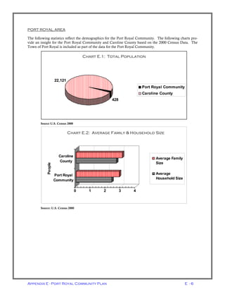
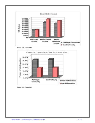
SlideShare a Scribd company logo
1 of 38
Download to read offline
Appendix E
County of Caroline, Virginia
Port Royal Community Plan
Adopted by the Board of Supervisors
November 23, 2004
Appendix E - Port Royal Community Plan E - 1
Table of Contents
Page
Acknowledgments 2
Introduction 3
Demographics & Growth Trends 5
Community Design 10
Land Use 14
Public Facilities 20
Economic Development 26
Environmental Resources 30
Transportation 34
5-26-09
APPENDIX E - PORT ROYAL COMMUNITY PLAN
Appendix E - Port Royal Community Plan E - 2
Caroline County Board of Supervisors
Calvin Taylor, Chairman
Wayne Accors, Vice-chairman
Robert Farmer
Maxie Rozell
Floyd Thomas
County Administrator
Percy C. Ashcraft
Caroline County Planning Commission
Virginia Scher, Chairman
M. Raymond Piland, III, Vice-chairman
Joseph Brown, Jr.
Dr. Milton Bush
William L. Smith
Port Royal Town Council
Tonya B. Harmon, Vice-mayor
Robert Coleman
Mark Hampton
Jerry A. Jones
Della F. Mills
Rosie Ella Upshaw
Mayor
Herb Posner
Town of Port Royal Planning Commission
Alexander Long V, Chairman
Terri Harrison, III, Secretary
Mark Hampton
Carol Gutierrez
Nancy Wick
Port Royal Citizen Planning Committee
Nancy Long, Chairman
Bill Wick, Vice-chair
Cleo Coleman
Tommy Horne
Della Mills
Jimmy Street
Project Staff
Gary D. Mitchell, Project Planner
Mathew Stafford, Planner
Michael A. Finchum, Director of Planning and Community Development
Rappahannock Area Development Commission
ACKNOWLEDGEMENTS
The members of the Port Royal Area Planning Advisory committee gratefully acknowledge the efforts of the
following officials, organizations and individuals who assisted in the preparation of this document. We also
thank the citizens who participated in the process.
Appendix E - Port Royal Community Plan E - 3
INTRODUCTION
The Port Royal Community Plan is part of the Caroline County Comprehensive Plan, the official policy
guide for future development decisions. Both Plans are long range in nature and provide a picture of how the
community wishes to develop over the next 15 to 20 years.
As a policy document, the plan provides a framework for the community’s residents and decision makers to
conceptualize how the community should look and function. The major goals of the Community Plan aim
to guide the community into the future.
GOALS
• Provide information for the public and promote decisions to guide the community in
the future.
• Promote the interests of the Community as a whole.
• Enhance, describe and promote the Community’s physical development.
• Evaluate short-term actions against long-term goals.
• Recognize the natural and historical resources, and architectural significance of the Port
Royal Community, as well as the surrounding area to more effectively preserve, protect
and integrate them into an orderly pattern of development.
The overall goal of the Port Royal Community Plan is best revealed by the Vision Statement:
The Port Royal Community is a diverse, family friendly, rural community of scenic
beauty that embraces its heritage and welcomes others to experience its wonders along the
historic Rappahannock River, which serves as a gateway to Caroline County and the Mid-
dle Peninsula of Virginia.
PORT ROYAL PLANNING PROCESS
PLAN ORGANIZATION
The Community Plan is divided into several sections that cover the following topics; design, land use, public
facilities, economic development, environmental & historical resources and transportation. Each section has
a general discussion, which is followed by the Goals and Action Strategies.
An implementation schedule is provided in each section of this plan. This schedule provides recommenda-
tions as to the timing of the specific strategies to be implemented.
PLANNING PROCESS
The process began in the spring of 2002, as a bottom-up, or citizen driven, process with a twelve member
Citizen Planning Committee. Staff from Caroline County, Town of Port Royal and Rappahannock Area
Development Commission provided technical support to the committee. A Community Survey was con-
ducted, the results of which were tabulated and analyzed.
The planning committee held monthly meetings advertised in the local media and met with a wide variety of
public and private interest groups and agencies. In the fall of 2003, the committee participated in a planning
exercise, composed of three parts. First, the committee members were asked to identify a key parcel(s) in the
Port Royal Community that when and if developed, may potentially completely change the nature of the
community. Secondly, they were asked to identify all the resources in the community. Finally, the commit-
Appendix E - Port Royal Community Plan E - 4
tee members developed a list of “Hot Button” issues. After identifying these items, the committee ranked
their findings and compiled the top three items from each part and used the lists to help draft this plan.
Key Parcel Analysis
1. The parcels at the intersection of Route 301 & 17
2. The Wildlife Refuge
3. Brown’s Motel (now demolished)
Community Resource Analysis
1. Historic Resources
2. Rappahannock River & Environs
3. Locations and access of the Community
Hot Button Issues
1. (tie) Appearance of buildings in the community (design concerns)
1. (tie) Lack of central water/sewer
2. Town-County Cooperation
3. Town Water System
In the fall of 2003, the committee divided itself into sub-committees to work on the various topics created
from the planning exercise. Upon completion of this work in March 2004, the committee held an “Open
House” to display the results of their work and findings of the sub-committees. Again, the public and special
interest groups were invited to speak and participate in the planning process. Some of the interest groups that
participated were Fredericksburg Home Builder’s Association, Caroline County Chamber of Commerce, and
Piedmont Environmental Council.
After the Open House, County staff developed a draft plan document for review and comment by the Plan-
ning Commission. It was later presented to the Town of Port Royal for review. In October 2004, the Port
Royal Community Plan was presented to the Planning Commission, where it was forwarded to the Caroline
County Board of Supervisors with a favorable recommendation. The Board of Supervisors adopted this
Community Plan November 23, 2004.
Appendix E - Port Royal Community Plan E - 5
DEMOGRAPHICS & GROWTH TRENDS
OVERVIEW
This section briefly reviews recent trends in demographics such as age, household composition and age in-
come. This summary and analysis of existing conditions and trends is intended to provide background infor-
mation and rationale for the various goals and action strategies outlined in the Community Plan. In order to
plan effectively for the future, it is important to understand where the Community has been, where it is and
where it is headed.
SUMMARY OF CAROLINE COUNTY GROWTH TRENDS
This information is a brief summary of information that is contained in the 2003-04 Caroline County Demo-
graphic Analysis. This summary provides public officials, local citizens, and other interested parties with ba-
sic information on past trends and current conditions for the County.
Caroline County has experienced increases in population, housing, and employment over the last thirty
years. From 1970 to 2000, the County’s population increased from 13,925 to 22,121, which represents a
population growth of nearly 59%. In 1980, the County population was 17,904 rising to 19,217 by 1990,
which represented an increase of approximately 7.3%. The County’s total population reached 22,121 accord-
ing to the 2000 Census. This is an increase of approximately 15% over the previous Census findings. The
Weldon-Cooper Center for Public Service of the University of Virginia, estimates that by 2010 the County
population will increase by 13.5% to 25,099.
As of July 2002, the Weldon-Cooper Center released provisional estimates of population indicating a total
population of 22,200. This is an increase of 0.5% since the 2000 Census or approximately 0.2% per year.
Based upon historical trends and current building permit activity, the population will continue to grow at a
similar rate well into the next decade.
The economic strength of the County has also seen significant increase. The County’s median household
income continues to rise at a steady rate. The 1970 Census reveals a median household income of $19,991.
The 2000 Census indicated that the County’s median household income was at $39,845. Since 1970, the me-
dian household income has risen by $19,854, an increase of almost 100%.
Total employment in the County has also grown steadily over the last 30 years. According to the 1970 Cen-
sus, Caroline County had 3,569 total employees, which increased to 4,741 employees by 1980 and 5,738 em-
ployees by 1990. By 2000, there were 7,978 employees, an increase of 124% from 1970. The economy also
became more diversified over this time period, with increases in employment in the Construction, Service,
FIRE (finance, insurance and real estate), Wholesale and Retail Trade sectors.
Appendix E - Port Royal Community Plan E - 6
PORT ROYAL AREA
The following statistics reflect the demographics for the Port Royal Community. The following charts pro-
vide an insight for the Port Royal Community and Caroline County based on the 2000 Census Data. The
Town of Port Royal is included as part of the data for the Port Royal Community.
Source U.S. Census 2000
Source: U.S. Census 2000
Chart 1.0: Total Population
428
22,121
Port Royal Community
Caroline County
Chart E.1: Total Population
0 1 2 3 4
Port Royal
Community
Caroline
County
People
Chart 1.1: Average Family & Household Size
Average Family
Size
Average
Household Size
Chart E.2: Average Family & Household Size
Appendix E - Port Royal Community Plan E - 7
Source: U.S. Census 2000
$0
$5,000
$10,000
$15,000
$20,000
$25,000
$30,000
$35,000
$40,000
$45,000U.S.Dollars
Per Captia
Income
Median Family
Income
Median
Household
Income
Chart 1.2: Income
Port Royal Community
Caroline County
Chart E.3: Income
0.00%
5.00%
10.00%
15.00%
20.00%
25.00%
30.00%
PercentofTotalPopulation
Port Royal
Community
Caroline County
Chart 1.3: Under 18 & Over 65 Populations
Under 18 Population
Over 65 Population
Chart E.4: Under 18 & Over 65 Populations
Appendix E - Port Royal Community Plan E - 8
fSource: U.S. Census 2000
Source: U.S. Census 2000
From this series of charts it is evident that the demographics of the Port Royal Community mirror the
County in many ways. However, it differs in several aspects. First, the average family and household size in
the Port Royal Community is considerably smaller than that of the County as a whole. Average household
and family size are smaller by approximately 13% and 7% respectively, possibly due to the large agricultural
operations within the Community. A second reason could be the related to the income differences that exist
between the County the Port Royal Community. Here, we find that while per capita income levels are rela-
tively equal, the median household and family incomes differ significantly. These two income measures are
approximately 18% below that of the County as a whole. Lower incomes may have an impact for adequately
providing for a larger household/family.
Another factor that relates to these differences in income and average household/family size is shown in
Chart E.7. The occupations held by the residents of the Port Royal Community are predominately in the
service sector of the economy. While nearly 24% of residents in the County are classified as management or
professional, only 4.2% of the Port Royal Community have this classification. Over 27% of the Port Royal
Community workers are classified as being within the service sector of the economy. Historically, the service
0
20
40
60
80
100
120
140
160
180
NumberofHousing
Units
Housing Units Housing Unit
without a
Motor Vehicle
Available
Housing Unit
Lacks
Complete
Plumbing
Chart 1.4: Housing Characterisitics of the Port Royal CommunityChart E.5: Housing Characteristics of Port Royal
0 20 40 60 80 100 120 140
Number
Number of
Families
Families with
Children under 18
Chart 1.5 Characterisitics of Family Households in the Port
Royal Community
Chart E.6: Characteristics of Family Households in Port Royal
Appendix E - Port Royal Community Plan E - 9
sector of the economy offers lower wages than the manufacturing sector. This supports the apparent links
between lower wages and smaller households/families.
Source: U.S. Census 2000
The Census data supports the results of the Community Survey conducted as part of this planning project.
As discovered from the Citizen Survey, a vast majority of the residents own their own home and work in the
service industry. Additionally, the majority of the respondents indicated that they live in a two-parent house-
hold with a child under18 years of age.
0.00%
5.00%
10.00%
15.00%
20.00%
25.00%
30.00%
Percentage
Managers &
Professionals
Services
Chart 1.6: Occupation of Residents
Port Royal Community
Caroline County
Chart E.7: Occupation of Residents
Appendix E - Port Royal Community Plan E - 10
COMMUNITY DESIGN
OVERVIEW
The Port Royal Community desires to see all new construction as well as any re-development of existing sites
reflect its heritage through the use of architectural standards and improved site design. Future growth of the
Community needs to protect the small town character and significant historic properties located in the area.
Improvements in the appearance and design of the community is a major factor identified by the citizen plan-
ning committee.
NATURAL ENVIRONMENT
The sub-committee, citizen planning committee
and citizen survey identified preservation of the
natural environment, agricultural heritage, and
views of the Rappahannock River as important
goals. Threats to these resources include insensi-
tive and incompatible development, inconsistent
regulations, pollution and litter, and the lack of
appreciation of scenic beauty. The committee
and the survey reflected a desire to protect his-
toric buildings and sites within the Port Royal
Community. Other special characteristics of the
community are its tranquility, quietness, farm-
houses, large, expansive agricultural landscapes
with scattered forests along fence rows, and
creek basins leading to the river.
GATEWAYS
As identified in the Community Vision Statement, the Port Royal Community is the gateway to Caroline
County and the Middle Peninsula. A gateway needs to provide an inviting picture and gesture of welcome to
visitors and tourists, similar to a well-hung gate or a neatly trimmed hedge in front of a well-kept home. The
entrance to a community should reflect the care and quality of the environment within. The Port Royal
Community has four major entrances: east bound on U.S. Route 17 near Samuel’s Corner; west bound on
U.S. Route 17 at the Caroline-Essex County line; north bound on U.S. Route 301 at the boundary of Fort
A.P. Hill; and south bound on U.S. Route 301 at the Rappahannock River Bridge.
There are a variety of methods to address the appearance of
the gateways of the Port Royal Community, ranging from
the Virginia Department of Highway’s Adopt-A-Highway
program to neighborhood cleanup drives and use of volun-
teers to establish and maintain entrance feature landscaping.
These are the types of programs that should be initiated by
the residents of the Port Royal Community.
The principal roads leading into the Port Royal Community
need special attention and care as development occurs along
these roads to maintain the gateways. Particular attention
needs to be paid attention to signage and landscaping of
developments on these corridors. The citizen committee
and the survey expressed concern about the landscaping and
appearance of non-residential development along the major roads in the community. The creation and im-
plementation of a development standards policy by the County has been identified as one solution to this
concern. Ideally, such a policy would require the planting of street trees and other landscaping on non-
Intersection of Routes 17 & 301 in Port Royal
Appendix E - Port Royal Community Plan E - 11
residential parcels along with architectural treatments that respect the historic character of the community.
The integration of Low Impact Development techniques (LID) with the principles of traditional neighbor-
hood development (TND) is strongly supported by citizen planning committee and would provide the frame-
work for the implementation of a development standards policy.
COMMUNITY IDENTITY & FUTURE DEVELOPMENT
The Port Royal Community is a small community with many identities. It is a historic village along the Rap-
pahannock River, a rural farming community, and an emerging commercial center. The area exudes nostal-
gia of a simpler time in its tight-knit residential areas. The real issue is how these identities can survive while
still promoting and preparing for the growth that will eventually come to the area.
Priority items include promotion of historic heritage and tourism, preservation of scenic views and the natu-
ral environment and stimulating redevelopment of existing commercial sites in ways that are compatible with
the community’s historic past. The following photographs show some of the historic structures located
within the Port Royal Community and how future development should be designed so that they are compati-
ble with these types of existing buildings.
Riverview – c. 1846Johnston – c. 1750
Townfields – c. 1745Pearson – c. 1770
Appendix E - Port Royal Community Plan E - 12
GOALS, ACTION STRATEGIES AND IMPLEMENTATION
GOAL 1.1: ENSURE THAT ARCHEOLOGICAL RESOURCES, HISTORICAL HERITAGE AND SCENIC
BEAUTY OF THE PORT ROYAL COMMUNITY ARE PRESERVED, ENHANCED AND UTILIZED
AS AN ASSET.
Action Strategy 1.1-1: Identify and restrict development in suspected archeologically rich areas until
after due exploration of the site.
Action Strategy 1.1-2: Require open space landscaping and compatible fencing throughout the plan-
ning area.
Action Strategy 1.1-3: Restrict Building heights to 2.5 stories.
Action Strategy 1.1-4: Encourage the use and preservation of trees and plantings near structures.
GOAL 1.2: PRESERVE THE NATURAL BEAUTY OF THE PORT ROYAL COMMUNITY.
Action Strategy 1.2-1: Residences should front on off-site streets.
Action Strategy 1.2-2: Explore clustered development practices with maintenance of active agricul-
tural practices.
Action Strategy 1.2-3: New subdivision roads should be designed to be less intrusive and reflect the
rural character of the community.
Action Strategy 1.2-4: New roads should follow existing contours with limited main road access.
Action Strategy 1.2-5: Existing tree lines should be preserved whenever possible.
Action Strategy 1.2-6: Existing agricultural buildings should be preserved when feasible.
Action Strategy 1.2-7: Disturbance of topography, wildlife, existing residents and businesses during
the construction of roads, structures, improvements, should be minimized.
Action Strategy 1.2-8: Create a gateway via the use of a marker or monument on the major routes
leading into the Port Royal Community.
Action Strategy 1.2-9: Develop a network of community volunteers to assist in Community beauti-
fication and assistance to property owners who are physically, mentally and/or economically disad-
vantaged.
GOAL 1.3: PRESERVE HISTORICAL AND AGRICULTURAL CHARACTER, USING CURRENT CONSERVA-
TION OR TRADITIONAL NEIGHBORHOOD DEVELOPMENT METHODS.
Action Strategy 1.3-1: Preserve areas with productive soils for continued agricultural and forestry
uses by preserving blocks of land large enough to allow for efficient operations.
Action Strategy 1.3-2: Preserve areas containing unique and sensitive natural features such as wild-
life habitats, migration corridors, steep slopes, streams, and wetlands.
Action Strategy 1.3-3: Minimize land disturbance and erosion through retention of existing vegeta-
tion and use of Low Impact Development techniques.
Action Strategy 1.3-4: Preserve scenic views, the River, historic and archeological sites.
Appendix E - Port Royal Community Plan E - 13
Action Strategy 1.3-5: Provide for the active and passive recreational needs of residents.
Action Strategy 1.3-6: Create traditional neighborhoods with access to open space amenities, repli-
cate historic development patterns, and create a strong community identity.
IMPLEMENTATION
Each method of implementation has the associated action strategy (AS) that correspond to this activity iden-
tified.
WITHIN 5 YEARS;
• Encourage new construction to reflect the context and character of the existing community (AS1.1-1,
2, 3, & 4).
• Develop a program to help developers achieve an outcome representative of the community’s desire
for a quality built and natural environment (AS1.1-1, 2, 3, & 4).
• Enact ordinances requiring the use of Low Impact Development (LID) methods (AS 1.2-7 & 1.3-3).
• Dedicate resources to create a gateway feature at each of the four entrances of the Port Royal Com-
munity (AS 1.2-8 & 1.3-6).
• Support programs that foster community pride including initiatives to enhance community appear-
ance (AS 1.2-8 & 9).
• Initiate an annual community clean-up day (AS 1.2-8 & 9, 1.3-6).
• Develop a volunteer network to address property maintenance issues occurring on property where
the owners are economically or physically disadvantaged (AS 1.2-9)
WITHIN 7 YEARS;
• Develop an inventory of significant trees on County/Town property and rights-of-way within the
community (AS 1.1-4, 1.2-2 & 4, 1.3-3).
• Initiate an urban forestry program to foster the replacement and planting of trees on public property
and rights-of-way (AS 1.1-4, 1.2-4 & 1.3-3).
• Develop a brochure recommending species, planting locations, and care for urban trees and land-
scaping (AS 1.3-1, 2, & 3).
• Perform a complete historic resources survey for the Port Royal Community, including the identifi-
cation archeological resources and sites (AS 1.1-1).
• Acquire more public access points along the Rappahannock River in the Port Royal Community (AS
1.3-5).
• Adopt a right-to-farm ordinance requiring the disclosure of activities associated with agricultural and
forestal operations to potential future residents of the Port Royal Community (AS 1.3-1 & 2).
WITHIN 10 YEARS;
• Actively pursue the acquisition of land to create and develop a community park within the Port
Royal area (AS 1.3-5).
Appendix E - Port Royal Community Plan E - 14
LAND USE
OVERVIEW
The Port Royal Community is characterized by the central Town of Port Royal and a number of small com-
mercial and residential developments that boarder the Town limits. A majority of the commercial develop-
ment is situated along U.S. Routes 17 and 301. The intersection of these two major roads is just southwest of
the Town’s municipal boundaries. Beyond this compact and central area lies large agricultural tracts and
forest land. This section of the County has been noted for its natural beauty, the winding river, scenic over-
looks and “slow-paced” lifestyle.
Increasing development pressure from the Northern Virginia Metropolitan Area is starting to cause some
changes in this region of the County. While growth cannot be stopped nor is it the desire to stop growth, the
citizens of the Community want to control or manage such growth.
GROWTH MANAGEMENT
Growth management should be a coordinated effort by Caroline County and the Town of Port Royal. Such
coordination will provide a more efficient plan for future growth in accordance with the Port Royal Commu-
nity Plan. A growth management strategy needs to be developed to identify and guide new growth to loca-
tions where public facilities can be provided. Public facilities include the provision of adequate roads, storm
water management, schools, parks, emergency services, and water and sewer. Open space and agricultural
areas, as well as environmentally sensitive areas requiring protection, need to be identified and appropriate
preservation programs initiated by both the Town and the County. The implementation of such a program
will guide growth and help to maintain an important and desired distinction between the growth and rural
area of the Port Royal Community.
One method of managing growth is to promote the use of Traditional Neighborhood Designs (TND), which
incorporates business and residential uses in a single unified development plan. Such developments promote
the linking of residential areas to non-residential areas via sidewalks, trails and bike lanes. Additionally,
TND’s often promote the use of historic and “human-scale” architecture as it relates to site and building de-
signs. Human scale relates to the height and mass of the building. Typically human scale architecture per-
mits structures to be no more than two to three stories in height. Additionally, this type of development cre-
ates unique places for community gatherings while promoting non-motorized modes of transportation.
Another benefit to a the TND type of development is that it typically preserves open space by promoting the
clustering of homes and businesses into compact areas within the overall development along with common
open spaces for passive recreational uses. The citizen sub-committee and responses from the various partici-
pants during the Open House supported this approach as it relates to managing future growth in the Port
Royal Community.
INITIAL GROWTH MANAGEMENT STRATEGY
As outlined in the demographic profile of the
Port Royal Community, this area of the County
saw consistent and increasing growth pressures
during the 1990s and into the early 21st
Cen-
tury. In 2002, the Caroline County Board of
Supervisors, recognizing this trend, enacted the
Resource Sensitive Area Overlay District in the
County Zoning Ordinance, a portion of which
is outlined in green on the map to the right.
The major effect of this ordinance change was
to increase the minimum lot size for by-right
development from 10 acres to 25 acres. Addi-
Appendix E - Port Royal Community Plan E - 15
tionally, this district limits access to existing public roads for future developments and attempts to minimize
the visual impact new development have from public roads and the Rappahannock River. Finally, this over-
lay district prohibits the clear cutting of forests and excessive cuts and fills typically associated with new de-
velopment.
FUTURE LAND USE
The citizen sub-committee adopted the existing land use map with only two changes. First was to rename
those areas currently identified for low to medium density residential to planned development. A low to me-
dium density residential designation permits up to seven units per acre on a centralized water and sewer sys-
tem, while a Planned Development (PD) designation allows the County the flexibility to adjust densities
based upon the merits of the individual application. However, a PD does require that 50% of any residential
area be preserved as open space. Additionally, only through a PD designation is a TND type of project be
possible.
This change is recommended because the Port Royal Community prefers the use of sustainable development
centered on integration of land uses and Traditional Neighborhood Design (TND) utilizing Low Impact De-
velopment techniques (LID). Additionally, the use of such techniques substantially lessens the effect of new
development on the natural environment, thereby helping to preserve the environmental quality of the Com-
munity.
The second change to the Land Use Map is that the growth boundary enlarged north of U.S. Route 17 to the
edge of Goldenvale Creek. South of U.S. Route 17 the growth boundary now follows the eastern most
branch of Goldenvale Creek to the boundary of Fort A.P. Hill. This enlargement is designated as “Future
Development” on the land use map, indicating that this area has the potential to be developed in the future.
Any specific development that occurs in such an area would necessitate a rezoning and possibly Comprehen-
sive Plan amendment. The Port Royal Community Future Land Use Map are shown on Map F-1.
Appendix E - Port Royal Community Plan E - 16
MapE-1
Appendix E - Port Royal Community Plan E - 17
GOALS, ACTION STRATEGIES AND IMPLEMENTATION
GOAL 2.1: MANAGE FUTURE DEVELOPMENT IN THE PORT ROYAL AREA WHILE PRESERVING THE
RURAL FEATURES AND QUALITY OF LIFE.
Action Strategy 2.1-1: Ensure that rural development is sensitive to the needs for rural preservation
and the protection of environmentally sensitive areas.
Action Strategy 2.1-2: Require open space in rural developments to protect agricultural lands, forests,
and preserve the rural character of those areas.
Action Strategy 2.1-3: Preserve the rural character of the Port Royal area by discouraging rural subdi-
visions that utilize agricultural lands, forest lands, and open spaces.
Action Strategy 2.1-4: Encourage the use of conservation easements and land trusts in rural areas to
facilitate open space preservation and the protection of agricultural lands, forests, natural areas, and
environmentally sensitive areas.
GOAL 2.2: PROMOTE THE USE OF TRADITIONAL NEIGHBORHOOD DESIGN TECHNIQUES AND FO-
CUS ALL NEW DEVELOPMENTS IN AND AROUND THE TOWN OF PORT ROYAL.
Action Strategy 2.2-1: Require the submission of concept plans with rezoning and special exception
permits for all developments.
Action Strategy 2.2-2: Provide for a diverse of housing mix in the areas designated for residential de-
velopment.
Action Strategy 2.2-3: Permit low and medium density residential development in appropriate
amounts and locations in the secondary growth area.
Action Strategy 2.2-4: Encourage development to locate in areas with planned public facilities.
Action Strategy 2.2-5: Establish standards for acceptable levels of service for public facilities and en-
sure those levels of service are maintained.
Action Strategy 2.2-6: Phase development in conjunction with the availability of public facilities.
GOAL 2.3: PROTECT EXISTING AND PLANNED DEVELOPMENT FROM ENCROACHMENT OF INCOM-
PATIBLE LAND USES.
Action Strategy 2.3-1: Evaluate rezonings and special exception permit applications to ensure consis-
tency with the Comprehensive Plan and compatibility with existing and planned land use, as well as
the character of the area.
Action Strategy 2.3-2: Require documentation of impacts of a proposed development, including but
not limited to, traffic studies, historical and archeological resources, water quality and quantity and
other environmental factors and fiscal impact. Recommendations from such studies should be ade-
quately addressed prior to preparation of development plans or as part of the application.
Action Strategy 2.3-3: Require open space in developments within the secondary growth area to pro-
vide for sufficient recreation, passive recreation, landscaping and buffering/screening.
Appendix E - Port Royal Community Plan E - 18
IMPLEMENTATION
Each of method of implementation has the associated action strategy (AS) that correspond to this activity
identified.
WITHIN 5 YEARS;
• Provide the resources needed to implement a fully functioning GIS system (AS 2.1-1 & 2.3-1).
• Work with Fort A.P. Hill to develop a related lands study. Much of this information will be avail-
able in a digital format for incorporation into the GIS system (AS 2.1-1, 2.3-1, 2.2-5 & 6).
• Development and implementation of performance criteria for new development and preservation
(AS 2.2-5, 2.3-1 & 2).
• Revise the zoning ordinance to permit accessory apartments provided the home is owner occupied
(AS 2.2-2).
• Explore permitting density bonuses if a project provides resources to protect other environmentally
valuable land areas in the Community (AS 2.1-4 & 2.2-3 & 4).
• Adopt a Right-to-Farm Ordinance requiring property owners or their representatives to disclose to
potential buyers of real estate of the activities associated with agricultural and forestal operations (AS
2.1-1 & 3).
• Enact an Agricultural and Forestal District Program to preserve valuable crop and forest land re-
sources (AS 2.1-3 & 4).
• Revise the subdivision ordinance to require preservation of 20% of the development as permanent
open space for passive recreational use by the property owners of the subdivision (AS 2.1-2 & 2.3-3).
• Enact a Conservation Zoning District to provide for the preservation of open space in environmen-
tally sensitive areas such as wetlands, marches, forest lands, and valuable agricultural soils (AS 2.1-1
& 2.1-3).
• Develop the criteria and methodology to be used in evaluating rezonings, special exception permits,
site plans and subdivisions. Require the submission of general development plans for all special ex-
ception permits and rezonings (AS 2.2-1, 2.3-1 & 2).
WITHIN 7 YEARS;
• Adopt an affordable dwelling ordinance, as permitted under the Code of Virginia, to provide a vari-
ety of housing for County residents (AS 2.2-2 & 3).
• Develop a greenway and open space plan for the Port Royal Community (AS 2.3-3).
• Explore the creation of a purchase of development rights (PDR) program to preserve valuable natu-
ral habitat, agricultural lands and forestry resources (AS 2.1-1, 2, & 4).
• After fully evaluating the alternative system that is installed and operating in the Dawn Community,
explore the possibility of using a similar sewage disposal system as an interim method to providing
such services in the Port Royal Community (AS 2.2-4 & 6).
Appendix E - Port Royal Community Plan E - 19
WITHIN 10 YEARS;
• Acquire the required land for potential future sites for emergency services, schools, and other public
facilities in anticipation of the need of such services (AS 2.2-5).
• Acquire additional public access points along the Rappahannock River in the Port Royal Commu-
nity (AS 2.2-5).
Appendix E - Port Royal Community Plan E - 20
PUBLIC FACILITIES
OVERVIEW
Public facilities and services are those minimum facilities and services that the County provides for the public
welfare. These include institutions, services, and land intended for general use to benefit of the Port Royal
Community as a whole. The quality of these public facilities and services contributes to and enhances the
County’s quality of life. Ensuring that public facilities are phased with the demand or need is a major growth
management concern.
Providing suitable and accessible public facilities and services is one of the essential functions of local govern-
ment. The efficiency and effectiveness of a local government is often determined by its ability to plan and
finance these types of facilities and services. However, the separation of the Port Royal Community from the
rest of the County, due to the presence of Fort A.P. Hill, will require many of these facilities and services to
stand alone or be provided in conjunction with the Town of Port Royal.
PUBLIC SAFETY
The safety of citizens is one of the major concerns of the Port Royal Community. The threat of crime, fire
and individual or community disaster calls for the placement of considerable emphasis on the facilities and
services related to the protection of citizens and their property.
EMERGENCY SERVICES
Caroline County provides fire and emergency
service coverage for the Town of Port Royal.
There is an identified need for the County to
replace the existing fire and emergency ser-
vices facility located in the Town of Port
Royal. Part of the need to replace the existing
facility is due to the lack of sleeping and living
quarters for professional and/or volunteer
staff. Another reason is the size of the build-
ing; emergency equipment that is too large to
fit within the confines of the current building,
seen in the picture to the left. In fact, some
equipment replacement has been delayed due
to this issue. The final reason to replace the
facility is that it is located on King Street
within the Town of Port Royal. At its current
location, access to U.S. Routes 301 and 17 is
achieved via the intersection of Cumberland
and U.S. Route 301, which has no traffic sig-
nal or other control measure to enable emer-
gency vehicles to enter the highway at this point. Any new site should be situated to have direct access to
U.S. Routes 301 or 17.
A related issue is the use of an emergency pre-exemption signal on the traffic light at the intersection of
Routes 301 and 17. This device receives a specific signal from emergency vehicles causing the light to
change, stopping all vehicle movements except those traveling in the direction of the emergency vehicle. Pro-
viding this type of signal will decrease the response time for emergency equipment passing through this inter-
section. All future traffic control devices installed in the County should have a pre-exemption signal in-
stalled.
Port Royal Fire & Rescue Station
Appendix E - Port Royal Community Plan E - 21
SHERIFF’S SUBSTATION
The community survey, along with the Citizen Planning Committee, expressed a desire to have increased
police protection in the Port Royal Community. During a meeting of the citizen planning sub-committee,
during which various governmental agencies were present, this desire was expressed to the representative
from the Sheriff’s Office, who stated that one possible solution to this would be the placement of a substation
in the Port Royal area. He further explained that such a facility exists in the Ladysmith Community, which
consists of a small building that serves as an office and interrogation room. However, he stressed that such a
facility would require a secure building since there is an interrogation room and the possible storage of evi-
dence collected by law enforcement.
When a new emergency facilities building is located in the Port Royal Community it should be designed to
meet the needs of the fire, rescue services and incorporate a Sheriff’s substation.
RECREATION & PARKS
The use of open space greenways, parks, and recreational programs is essential for the Port Royal Commu-
nity. These open spaces and programs enhance the social and psychological well being of citizens by provid-
ing them with enjoyable activities and settings in which to spend their leisure time. Conservation benefits are
also derived from the preservation of open space and park areas by maintaining the integrity of watersheds
and protecting wildlife habitats and water quality in streams and underground aquifers. The economic bene-
fits of preserving open spaces and offering recreational opportunities include increases in the value of sur-
rounding properties and an enhanced quality of life in Port Royal.
There are no County owned parks or recreation facilities in the Port Royal Community. The reason is that
there is a very small population that would utilize such a facility. Also, in the past, when the Parks and Rec-
reation Department held events in the Community there was a very small turn out. However, a recent resi-
dential subdivision approved for the area includes a tot lot, which is to be constructed and dedicated to the
County. While this is a park that is classified as a neighborhood park, it does provide a basis for meeting the
immediate needs of the Community.
The Citizen Planning Committee and the survey indicated a preference for the provision of some recreational
programs to be offered in the Port Royal Community. If a new emergency services building is constructed,
the existing facility could potentially be converted into a community center where various recreational pro-
grams could be provided.
SCHOOLS
The public school system is a primary component of any community. Schools are an area of community
focus and a gathering place for community and youth activities. Schools provide the essential function of
educating our children and preparing them to enter a diverse, expanding work force. There are two elemen-
tary schools that serve the Port Royal Community; Bowling Green Primary (grades K-2) and Bowling Green
Elementary (grades 3-5). Children who live in the Port Royal Community are transported over 15 miles to
these schools.
However, based upon historical growth patterns, the resource sensitive overlay district, and large productive
agricultural tracts of land, the Port Royal Community is not expected to experience substantial growth in its
school age population during this planning horizon.
Appendix E - Port Royal Community Plan E - 22
SOLID WASTE
The Caroline County Department of Public Works recently con-
structed a convenience site (pictured to the right) east of the Virginia
Department of Transportation (VDOT) service facility along U.S.
Route 17 in Port Royal. This site is manned by Public Works person-
nel and open to Caroline County residents. The solid waste collected
at this site is hauled to the King George County Landfill. The site is
expected to serve the needs of the Port Royal Community during this
planning horizon.
UTILITIES
The Town of Port Royal provides water service via a deep well with 80-110 gallons per minute pumped. The
Town has a single elevated water storage tank with a capacity of 20,000 gallons. The water system serves
199 persons and produces 19,600 gallons per day. The most recent usage reports show that the Town actu-
ally uses around 12,000 gallons per day.
An April 1986 survey of the water system revealed that the original WPA water system has deteriorated to
the point that 55% of households lack adequate water pressure, 43% report sediment in the water, 35% note
an unpleasant smell in the water, 24% report the water is off-color, and 68% of all households report one or
more problems with the water supply. Due to limited funding, some of these problems still persist. The
Town does not have a sewage treatment plant and sewage disposal is accomplished with individual septic
systems.
The County currently has a pilot program for a decentralized sewage disposal system as an alternative to the
traditional septic tank and drainfield. This pilot program is being installed in the Dawn Community. After
careful evaluation of the program in Dawn, the County may then choose to use this type of alternative sys-
tem in other parts of the County not currently served by public water and sewer system, such as Port Royal.
INFORMATION TECHNOLOGY
Information technology is a new component of the Community Plan. Given the rapid rate of technological
development and its ever increasing impact on people’s daily lives, this topic needs to be addressed as a part
of public facilities. Planning for how information technology may impact the Community in the future is
impossible due to its rapidity of change. However, we can focus on how this technology can serve the needs
of the citizens of the Port Royal Community.
The County has developed and began to implement a three tier technology plan to provide high speed inter-
net access to local government offices, schools and libraries. Currently, the County is in the midst of imple-
menting this plan, which involves the upgrading of the technology infrastructure of County facilities. The
next phase of this program will incorporate the development of a fully functioning GIS system, enabling the
last part of the technology plan to be implemented. The final phase is to make all possible business transac-
tions with the County accessible via the internet, otherwise known as “e-government”. The impact to the
residents of the Port Royal Community will be a more efficient government operation.
LIBRARY
The Caroline County Library system currently has four branches,
Dawn, Bowling Green, Ladysmith, and Port Royal. The Caroline
system is tied into the state system, but not is part of any other re-
gional or sub regional system. The Port Royal Branch has limited
hours and is staff by volunteers. A majority of the staffing of these
facilities is handled by volunteers. Expansion of the Port Royal
branch and offering additional hours and services in the future by
this facility will be dictated by the growth of the Port Royal Com-
munity.
Appendix E - Port Royal Community Plan E - 23
GOALS, ACTION STRATEGIES AND IMPLEMENTATION
GOAL 3.1: PROVIDE AN EQUITABLE LEVEL OF EMERGENCY SERVICE PROTECTION FOR THE PORT
ROYAL COMMUNITY, CONSISTENT WITH THE RESPONSE TIME PROVIDED IN OTHER AR-
EAS OF THE COUNTY.
Action Strategy 3.1-1: Obtain, through lease, proffer or purchase, an office area of sufficient size to be
used as a Sheriff’s Office substation.
Action Strategy 3.1-2: Determine the appropriate Fire and Rescue equipment level based on volume
of calls received.
Action Strategy 3.1-3: Determine the appropriate housing needs of personnel and equipment, keeping
in mind the physical increase in the size of multi-use equipment.
Action Strategy 3.1-4: Keep track of the number of unanswered calls to determine when the assistance
of paid Fire and Rescue professionals may be required.
Action Strategy 3.1-5: Install an emergency pre-emption signal on Route 301 to improve safety and
response time of Fire and Rescue units in an emergency.
Action Strategy 3.1.6: Use high quality construction materials and methods along with designing
County Facilities to “fit-in” with the character of the Port Royal Community.
Action Strategy 3.1.7: Develop a crime prevention program to assist business owners and individuals.
GOAL 3.2: PROVIDE AN EQUITABLE LEVEL OF RECREATIONAL SERVICES AND PROGRAMS FOR
THE PORT ROYAL COMMUNITY, CONSISTENT WITH SERVICE DELIVERY IN OTHER AR-
EAS OF THE COUNTY.
Action Strategy 3.2-1: Provide regular supervised transportation to allow those interested to partici-
pate in the current recreational programs being offered in other parts of the County.
Action Strategy 3.2-2: Obtain, through lease, proffer or purchase, and develop an area of land suffi-
cient to meet the recreational needs of the present population of the Planning Area. Ideally the prop-
erty would includeff access to the Rappahannock River.
Action Strategy 3.2-3: Develop a volunteer network to assist with recreational programming, as well
as maintenance and beautification of the community.
Action Strategy 3.2-4: Identify a site, or sites, where a Port Royal Community Center offering vari-
ous types of recreational programs can be located.
Action Strategy 3.2-5: Develop an informational brochure or other promotional materials to promote
recreational opportunities in the Port Royal Community.
GOAL 3.3: PROVIDE ADEQUATE PUBLIC UTILITIES TO PERMIT AND FOSTER THE GROWTH AND
PROSPERITY OF THOSE AREAS SURROUNDING THE TOWN CENTER, AS IDENTIFIED IN
THE LAND USE PORTION OF THIS DOCUMENT.
Action Strategy 3.3-1: Complete a study to determine the feasibility of constructing and operating
water and sewage treatment facilities to serve both the Town of Port Royal and the adjacent portions
of the County, as designated by the Land Use portion of this document.
Appendix E - Port Royal Community Plan E - 24
GOAL 3.4: PROVIDE ADEQUATE PUBLIC FACILITIES FOR SCHOOLS, LIBRARIES, AND INFORMATION
TECHNOLOGY INFRASTRUCTURE TO PERMIT AND FOSTER THE GROWTH AND PROSPER-
ITY OF THOSE AREAS SURROUNDING THE TOWN CENTER, AS IDENTIFIED IN THE LAND
USE PORTION OF THIS DOCUMENT.
Action Strategy 3.4-1: Use the Capital Improvements Program to properly plan and phase in improve-
ments for the following public facilities serving the Port Royal Community: schools, libraries, and in-
formation technology.
Action Strategy 3.4-2: Continue to implement the Technology Plan and expand the use of the
County’s web site to offer e-government services.
Action Strategy 3.4-3: Support the use of technology and a continual expansion and maintenance of
technological equipment and infrastructure.
IMPLEMENTATION
Each method of implementation has the associated action strategy (AS) that corresponds to this activity iden-
tified.
WITHIN 5 YEARS;
• Exhibit innovative design and use of high quality construction materials and methods in keeping
with the historic character of the Port Royal Community to serve as an example for the Develop-
ment Community (AS 3.1-1 & 6).
• Study options for and construct multi-use facilities for public safety, recreation, and libraries (AS 3.1-
1, 2, & 3).
• Develop an agreement between the Town and County to jointly fund and use public facilities (AS
3.1-1, 2, 3 & 6).
• Study long term community service requirements and growth patterns to plan for the location of ad-
ditional public facilities and services (AS 3.1-1, 2, 3 & 6; 3.2-2, 4; 3.3-1, & 3.4-1).
• Support the Virginia Scenic Byways and Scenic Rivers programs (AS 3.2-5).
• Include measures in traffic signal upgrades to help emergency personnel improve response times and
to ensure the safety of personnel traveling through signalized intersections (AS 3.1.5).
• Establish a committee of volunteers to provide assistance in the provision of recreational programs
and maintenance of recreational sites and/or landscaping (AS 3.2-3).
• Establish a partnership with the school system and/or FRED to provide the needed transportation
service to allow Port Royal residents and their children to participate in recreational programs of-
fered by the County (AS 3.2-1).
• Capitalize on tourism through the publication of brochures outlining recreational programs and wa-
terfront access points (AS 3.2-5).
• Monitor and upgrade, as necessary, communications equipment and technology for emergency per-
sonnel (AS 3.1-2, 3 & 4; 3.4-3).
• Using feedback from users, continually improve the County Web site (AS 3.4-1, 2 & 3).
Appendix E - Port Royal Community Plan E - 25
• Establish a “Community” section of the County website where various community events and infor-
mation can be posted (AS 3.4-1, 2 & 3).
WITHIN 7 YEARS:
• Fully implement the technology plan and prepare a way for e-government service delivery (AS 3.4-1,
3 & 3).
• Dedicate resources to provide first rate technology service to the County offices and school system
(AS 3.4-1, 2 & 3).
• Construct a public safety building that incorporates the fire, emergency services and a sheriff substa-
tion needs in a single facility (AS 3.1-1, 2, 3 & 6).
• Study the need for additional personnel as calls for service increase (AS 3.1-2, 3, & 4).
• Work with the Sheriff’s Office to implement a crime prevention program by offering information and
educational opportunities for individuals and businesses to increase personal and community safety
(AS 3.1-7)
• Remodel and convert the existing fire and emergency services building into a Community Center
offering various recreational programs to the members of the Community (AS 3.1-6 & 3.2-4).
• Acquire land along the Rappahannock River to ensure public access to the river, preserve sensitive
environmental areas and provide water based recreational activities (AS 3.2-2).
• Develop an open space plan for the Community that includes a greenway element to link different
communities of the County (AS 3.2-2).
• Based upon the results of the pilot program of a decentralized wastewater system in the Dawn Com-
munity, evaluate its potential use for the Port Royal Community (AS 3.3-1).
• Work with private property owners to install dry hydrants on all storm water basins and/or ponds to
provide multiple sources of water for the suppression of fires (AS 3.1-2).
WITHIN 10 YEARS:
• Continually upgrade of the GIS system with the latest technology (AS 3.4-1, 2 & 3).
• Acquire land and easements to implement a greenways plan for the Community and the County as a
whole (AS 3.2-2).
• Encourage and support the installation of curb-to-home fiber optics (AS 3.4-1, 2 & 3).
• Connect all County facilities with fiber optics (AS 3.4-1, 2 & 3).
• Explore the potential of permitting some County staff telecommute to work a couple of days per
week (AS 3.4-1, 2 & 3).
Appendix E - Port Royal Community Plan E - 26
ECONOMIC DEVELOPMENT
OVERVIEW
Economic development refers the economic changes that occur due to growth and expansion. Economies
develop due to interactions among increasing populations, increasing numbers of employers and employees,
and increasing numbers of businesses providing goods and services for local consumption and export to other
communities.
The Port Royal Community has limited employment opportunities within the community. The vast majority
of the population commutes to other areas within and outside Caroline County for employment. The three
main sources of job creation are: (1) retention and expansion of existing businesses, (2) recruitment of new
businesses, and (3) formation of new businesses.
A majority of the Port Royal Community’s residents recognize that the community is poised for future
growth due to its proximity to Fredericksburg and Northern Virginia. The challenge to the County and the
Port Royal Community is to manage this growth in a manner that retains the Community’s rural character
and quality of life.
ECONOMIC DEVELOPMENT FACTORS
One major factor to consider in promoting economic development is the education level of the workforce. In
today’s economy of increasing technological advancements, the workforce must continually strive to add to
its skill set to offer the tools and abilities for which industries are looking when hiring new employees. In
1990, the Census revealed that 651 of the 2,946 persons over 25 years of age had either attended college or
obtained a degree. This represents approximately 22% of the population of the Port Royal Community.
Based upon the 2000 Census, the number of people in the community who attended or obtained a degree
rose nearly 30% to 803 persons. Continued strides in educational achievement should be encouraged and
supported to attract future business operations to the Community.
The presence or availability of infrastructure is another major factor in attracting future employers to the Port
Royal Community. Since the area is not scheduled to receive water and sewer service for at least a decade,
this is a challenge for any intensive development initiatives for the Port Royal Community. However, the
new decentralized sewer system may be an appropriate bridge to the area being served by a centralized sys-
tem in the future.
Another infrastructure factor is the road network. While the Community is served by two major U.S. High-
ways, any significant development in the area will be required to make improvements to the existing road
network to maintain the capacity of the road system. Such new developments will have to mitigate their im-
pacts on traffic and maintain a Level of Service (LOS) of “C” or better as it relates to the road network in the
community.
Site selection is also important for economic development. The Port Royal Community has an abundance of
small to medium size sites that could accommodate small business enterprises and many of these sites are
already zoned for business. Due to the infrastructure issues previously discussed, the County should refrain
from any future rezoning of agricultural land for business uses.
RECENT ECONOMIC DEVELOPMENT ACTIVITIES
The following illustrations show how private investment in the community is adapting old structures for new
commercial uses. Many of these projects are limited due to the lack of public water and sewer. If such ser-
vices were made available the possibility of more adaptive reuse projects could be realized. More of these
types of projects, which respect the historic character of the community, are needed in the Port Royal Com-
munity.
Appendix E - Port Royal Community Plan E - 27
Revitalized Commercial Buildings along U.S. Route 301
Redevelopment of SW Quadrant of Rt. 301 Redevelopment on U.S. Route 301
& Rt. 17
Appendix E - Port Royal Community Plan E - 28
GOALS, ACTION STRATEGIES AND IMPLEMENTATION
GOAL 4.1: CAPITALIZE ON THE HISTORIC HERITAGE AND SCENIC BEAUTY TO CREATE AN ENVIRON-
MENT THAT PROMOTES TOURISM, FOSTERS GROWTH AND EXPANSION OF EXISTING
BUSINESSES, WHILE ATTRACTING NEW SERVICE AND COMMERCIAL BUSINESSES TO
THE PORT ROYAL COMMUNITY.
Action Strategy 4.1-1: Complete the restoration of the Doctor’s Office and Masonic Lodge and open
them for public tours.
Action Strategy 4.1-2: Create an interactive kiosk and self guided tour guide to incorporate the events
that happened in Port Royal for the John Wilkes Booth Trail.
Action Strategy 4.1-3: Acquire resources to construct “pull-offs” where historical markers have been
erected in the County.
Action Strategy 4.1-4: Open a Visitor’s Center along with the Fish and Wildlife Service that would
serve as the northern entrance for use and enjoyment of the park.
Action Strategy 4.1.5: Develop adequate public facilities standards policy tied to acceptable levels of
service (LOS).
GOAL 4.2: EXPAND UPON CURRENT AND DEVELOP ADDITIONAL ACTIVITIES AND EVENTS TO MAKE
PORT ROYAL A DESTINATION THAT WOULD BRING PEOPLE TO THE AREA AND PATRON-
IZE LOCAL BUSINESSES.
Action Strategy 4.2-1: Continue to support and enhance the following Cultural Events that occur in
Port Royal;
a. School Trips to the Port Royal School House
b. July 4th
Celebration
c. Port Royal Homes Tour
d. Port Royal Day
Action Strategy 4.2-2: Develop a Port Royal Harvest Festival
a. Tie the festival to the agricultural heritage and history of the Port Royal Community.
b. Link the festival to the river with activities such as rowing and fishing competitions.
GOAL 4.3: EXPAND MARKETS FOR LOCAL BUSINESSES AND REDUCE THE IMPORTS INTO THE
COUNTY.
Action Strategy 4.3-1: Promote the purchases of local goods by residents, as well as private business
and the County.
Action Strategy 4.3-2: Aggressively market the County to businesses exporting much of their products
and services to other localities.
GOAL 4.4: PROMOTE THE PORT ROYAL COMMUNITY IN THE OVERALL ECONOMIC DEVELOPMENT
STRATEGY OF THE COUNTY WITH AN EMPHASIS ON JOB CREATION.
Action Strategy 4.4-1: Continue to offer a quality educational system for the County’s youth.
Action Strategy 4.4-2: Assist and encourage all local businesses to identify and penetrate new export
markets.
Action Strategy 4.4-3: Provide the necessary infrastructure to attract new businesses into the commu-
nity.
Appendix E - Port Royal Community Plan E - 29
Action Strategy 4.4-4: As part of the County’s overall economic development plan provide adequate
resources to make the Port Royal Community a choice location of incubator or start up businesses.
IMPLEMENTATION
Each method of implementation has the associated action strategy (AS) that corresponds to this activity iden-
tified.
WITHIN 5 YEARS;
• Caroline County and the Town of Port Royal should work with the GWRC in order to acquire suffi-
cient grant funds to assist with the restoration of several of the historic structures in the Community
(AS 4.1-1).
• Develop a self-directed driving tour of historic sites via brochures made available at the Virginia
Tourism Office and Regional and County Visitor’s Centers (AS 4.1-2 & 3).
• Place an interactive kiosk in the Community to provide tourist related information for those entering
Port Royal (AS 4.1-2).
• Support existing community festivals and establish a Fall Harvest Festival for the Port Royal Com-
munity (AS 4.2-1 & 2).
WITHIN 7 YEARS;
• Work with the Federal Government to provide a combined center for Fish & Wildlife Center and a
Tourist Information (AS 4.1-4).
• Establish standards for future development relating to the architecture of new and/or renovated
buildings, landscaping and signage (AS 4.1-5).
• Aggressively market the Community as part of the County’s overall economic development strategy
(AS 4.3-1 & 2).
• Support and continue to provide a high quality public education system (AS 4.4-1)
• Develop a “Buy Caroline First Campaign” to support the purchase of goods, services, and materials
from local merchants instead of spending resources in other localities (AS 4.3-1).
WITHIN 10 YEARS;
• Establish adequate infrastructure to provide water and sewer service within the identified service
area boundaries (AS 4.4-3).
• Initiate a shell building program to attract new businesses into the Community (AS 4.4-4).
Appendix E - Port Royal Community Plan E - 30
ENVIRONMENTAL RESOURCES
OVERVIEW
The impact of future growth on the natural environment has become an issue of increasing interest and im-
portance in the Port Royal Community. The effects of population growth and economic development on the
natural environment include; clearing of trees, loss of plant and wildlife habitats, loss of valuable wetlands
and aquatic habitat, ground water contamination, degradation of surface water in streams and the river, dis-
ruption of natural drainage systems, air pollution, increased amounts of runoff, solid waste, and degradation
of scenic natural views.
Environmental deterioration need not be an inevitable consequence of population growth. The development
of new homes, businesses, industries, schools, and roads necessary to accommodate future population
growth can occur without unduly threatening the natural environment of the Port Royal Community. Using
the proper methods and techniques, new development can be designed and built in an environmentally sensi-
tive manner.
ENVIRONMENTAL ISSUES
Before we can begin to devise methods to protect environmentally sensitive lands, we must decide on what
“environmentally sensitive” means. This requires criteria to be developed that are meaningful and scientifi-
cally defensible. This information can be obtained from previous planning efforts in Caroline County and
other localities, as well as reviews of other governmental studies.
Once criteria are established and agreed upon, environmentally-sensitive lands and waters can be identified.
The most efficient and accurate way to accomplish this is through the use of remote sensing, such as aerial
photographs, in combination with readily available sources of information. Much of this information is
available in digital format and can be stored and displayed using a Geographic Information System (GIS).
Digital photography from 2003 is available to counties free of charge from the Commonwealth of Virginia
and can be used as a base map. Other layers of information available might include soils, floodplains, natural
heritage resources and other wildlife locations, and fish spawning streams. Additional information can be
obtained that is specific to the Port Royal Community, such as large forested blocks, zoning information, and
existing planned and approved developments. Once in GIS, these layers can be viewed individually, or lay-
ered to provide information on a variety of resource values. Almost anything that can be located on the
ground can be stored in GIS, making it an invaluable decision-making tool.
After important natural resources are identified and mapped, a threat assessment can be made, whether the
lands are in some form of protection, through conservation ownership or easement, or privately owned with
only moderate protection afforded them through regulation. Landowners may not be aware of the ecological
importance of their lands or programs available to help them protect natural resources. Providing this infor-
mation to landowners and encouraging their voluntary participation and stewardship may result in more con-
servation at little or no cost to the County.
Some landowners may not be interested or financially able to voluntarily restrict the use of their land, but
may have an interest in seeing it conserved. The County should develop partnerships with conservation
groups such as American Farmland Trust, Chesapeake Bay Foundation, The Conservation Fund, Friends of
the Rappahannock, The Nature Conservancy, and The Trust for Public Lands to develop programs and
grants that could lead to direct purchase, purchase of conservation easements, and purchase of development
rights (PDR) on private lands. Partnerships with government agencies such as the U.S. Fish and Wildlife
Service and Natural Resources Conservation Service can also lead to permanent protection of ecologically
significant lands.
One of the major threats to biological diversity is the proliferation of invasive plants into native ecosystems,
including Phragmites, Johnson Grass, Japanese Honeysuckle, Autumn Olive, Japanese Stilt Grass, Tree of
Heaven, and others. Partnerships, such as the Rappahannock Phragmites Action Committee, have formed to
Appendix E - Port Royal Community Plan E - 31
map and control these species within the Port Royal Community. The Rappahannock River Valley National
Wildlife Refuge started to address invasive species issues on refuge lands in Port Royal, but many threats
remain. The County should take advantage of existing partnerships and programs to begin identifying the
extent of this threat, educate landowners, and take appropriate control measures as funding permits.
Once the most environmentally-sensitive lands are identified, loss of these lands through development should
be avoided. This can be accomplished through new and existing zoning regulations, landowner education,
and encouraging voluntary participation in protection and restoration programs.
Where development does occur, it is important to protect downstream resources through implementation of
storm water management procedures. A new approach, termed “low impact development,” or LID, has
been successfully implemented in other nearby localities in Virginia. In partnership with The Friends of the
Rappahannock, localities have made low impact development part of their local codes for development pro-
jects. The premise, according to the Friends of the Rappahannock Web Site is “to replicate the pre-
development water flow and water quality from a development site.” Implementation of LID technology can
protect environmentally-sensitive lands from non-point source pollution, which often costs less than conven-
tional development methods.
No zoning or regulatory program to protect environmentally-sensitive lands will be successful without strict
enforcement. Education and promoting voluntary compliance should always be the precursor to punitive
measures, but there will be instances when enforcement is necessary. Non-enforcement can lead to further
non-compliance and loss of important natural resources. In order to ensure enforcement, the County needs
to dedicate sufficient resources to see that proper enforcement of the Ordinance is addressed.
Appendix E - Port Royal Community Plan E - 32
GOALS, ACTION STRATEGIES AND IMPLEMENTATION
GOAL 5.1: PRESERVE AND IMPROVE THE ENVIRONMENTAL QUALITY OF THE PORT ROYAL COM-
MUNITY THROUGH MEASURES PROTECTING ENVIRONMENTALLY SENSITIVE AIR, WATER,
LAND AND WILDLIFE RESOURCES.
Action Strategy 5.1-1: Develop criteria for identifying environmentally sensitive areas such as hydric
or highly-erodible soils, presence of wildlife concentrations and locations of rare or threatened species
or plant communities, floodplains groundwater recharge areas, and large, un-fragmented blocks of for-
est habitat.
Action Strategy 5.1-2: Using established criteria, identify environmentally sensitive areas and deter-
mine their protection status.
Action Strategy 5.1-3: Establish a Geographic Information System (GIS) to store and display land use
and other information such as aerial photography, soils, wetlands, forest blocks, existing zoning,
Chesapeake Bay Resource Protection Areas (RPA), floodplains, wildlife concentrations, natural heri-
tage resources, conservation easements, and fish spawning streams.
Action Strategy 5.1-4: Inform landowners of sensitive lands, the resources that these lands support
and why they are important to protect.
Action Strategy 5.1-5: Encourage voluntary participation in programs to conserve natural resources
and promote the concept of land stewardship.
Action Strategy 5.1-6: Develop partnerships with conservation organizations and other government
agencies to protect the most sensitive and threatened lands through direct purchase, conservation ease-
ments, and/or a purchase development rights program.
Action Strategy 5.1-7: Identify and control invasive species that threaten biological diversity.
GOAL 5.2: PROTECT ENVIRONMENTALLY-SENSITIVE LANDS FROM INAPPROPRIATE DEVELOP-
MENT.
Action Strategy 5.2-1: Avoid residential and commercial development on documented environmen-
tally-sensitive lands.
Action Strategy 5.2-2: Institute Low Impact Development methods as part of all residential and com-
mercial development projects.
Action Strategy 5.2-3: Cooperate with land owners and government agencies, such as the Soil and
Water Conservation District and the Virginia Department of Forestry, to encourage the use of best
management practices and farm conservation plans during agricultural and silvicultural activities.
Action Strategy 5.2-4: Enforce new and existing regulations, especially those developed under county
zoning ordinances and the Chesapeake Bay Preservation Act.
IMPLEMENTATION
Each method of implementation has the associated action strategy (AS) that corresponds to this activity iden-
tified.
WITHIN 5 YEARS;
• Development and implementation of a GIS system to use in analysis of all development proposals
submitted to the County (AS 5.1-1, 2, 3; 5.2-1).
Appendix E - Port Royal Community Plan E - 33
• Coordinate the GIS development with data needs and resources of other County, State, and Federal
agencies. Promote the sharing of data resources to improve efficiency (AS 5.1-3, 4, 5, & 6).
• Adopt LID methods as part of a countywide development standard policy (AS 5.2-2).
• Develop brochures to illustrate the benefits of land conservation (AS 5.1-4, 5, 6).
• Encourage the creation and use of an agricultural and forestal district program to preserve farmland
(AS 5.1-4, 5; 5.2-3).
• Adopt a conservation zoning district to protect wetlands and critical environmental lands (AS 5.1-4,
5; 5.2-3).
• Ensure the County has sufficient resources to plan development and protect the environment. These
resources include, but are not limited, the following; offices, equipment, vehicles and personnel (AS
5.1-3, 6; 5.2-3, 4).
• Support the monitoring and elimination of invasive species in the Port Royal Community (AS 5.1-
7).
WITHIN 7 YEARS;
• Explore and support the creation of a purchase of development rights program to protect sensitive
environmental land (AS 5.1-4, 5, 6).
• Provide adequate resources to update and maintain a GIS system (AS 5.2-4).
• Investigate the possibilities of retro-fitting some LID methods on sites that have been previously de-
veloped in the Port Royal Community (AS 5.1-7; 5.2-2).
WITHIN 10 YEARS;
• Develop and implement a web based GIS system to enable all citizens and developers to access in-
formation about environmentally sensitive lands in Caroline County and the Port Royal Community
(AS 5.1-6; 5.2-4).
• Support the creation of a streamside restoration program in the Port Royal Community (AS 5.2-4).
Appendix E - Port Royal Community Plan E - 34
TRANSPORTATION
OVERVIEW
This section provides an overview of the public transportation system that serves the Port Royal Community.
The future transportation system needs to be designed to offer alternative to the motor vehicles and encour-
age the use of other modes of transportation. This system should strive to balance safety, service, cost, com-
munity character, and convenience. Each part of the system is complementary to the other and serves as a
network for the community.
VIRGINIA DEPARTMENT OF TRANSPORTATION (VDOT)
There are two major types of roads in the
Port Royal Community; Primary and Sec-
ondary. The Primary Roads are U.S.
Routes 301 and 17, known as A.P. Hill
Boulevard and Tidewater Trail, respec-
tively. These roads are designed to carry
high volumes of traffic and larger motor
vehicles at 55 miles per hour. This class of
road typically offers transportation on a
regional or interstate scale.
Secondary roads are those designed and
intended for neighborhood/community
travel at slower rates of speed and with
less through traffic than primary roads.
There are several secondary roads in the
Port Royal community. Some of the more
heavily traveled secondary roads are: Pepmeier Hill Road, Skinkers Neck Road, and Buckner Road.
The Caroline County Board of Supervisors and VDOT identify projects for the Secondary Road 6 Year Plan.
This plan is revised annually based upon the funds allocated to the County for road improvements. Cur-
rently, there are no road improvements in the 6 Year Plan for the Port Royal Community. In fact, the only
road improvement that is underway or scheduled for the Port Royal Community is the bridge replacement on
U.S. Route 17 over Peumansend Creek. This project is on a primary road and is not subject to the 6 Year
Plan process.
In order to maintain the safety and efficiency of Primary Roads in Caroline County, the Board of Supervisors
adopted a highway overlay district. This district prevents excessive curb-cuts and promotes the use of shared
entrances, service roads, and inter-parcel connections, whenever possible. The overlay regulations also gov-
ern setbacks and other site design strategies to improve the efficiency of the existing transportation network in
the County. U.S. Routes 301 and 17 in the Port Royal Community fall within this overlay district and new
development is subject to its provisions.
PRIVATE ROADS
There are many miles of privately owned subdivision roads in the
County. These roads were not designed nor were they built to
VDOT standards. As a result, these roads often become a burden
and a source of conflict to property owners. These substandard
roads have become more heavily traveled and the deterioration
rate has increased. As of 1990, the use private roads in new subdi-
visions is prohibited. However, there are many lots platted and
recorded that were intended to be served by private roads.
U.S. Route 301
Appendix E - Port Royal Community Plan E - 35
TRANSIT SERVICE
The Port Royal Community is served by the Fredericksburg Regional Transit Service (FRED). FRED has
service to the Town of Port Royal one day a week. While there are a number of elderly residents in the Port
Royal Community, there is not a sufficient client base to expand this service at the present time. A systemic
review process of the client base should be performed to ensure that there is sufficient demand before expand-
ing transit service to the Port Royal Community. In this way the limited resources devoted for transit can be
efficiently allocated to provide this vital service to the Port Royal Community, as well as the rest of the
County.
RAIL SERVICE
There is no rail service in the Port Royal Community. Currently, the line running through the County is
dedicated to freight service and provides several spurs for freight. There are neither facilities nor services for
passenger rail service in Caroline County.
AIRPORT
There are no public airports located in Caroline County. Air transportation is provided to the County by
Richmond International Airport, Stafford Regional Airport and Shannon Airport in Spotsylvania County.
BIKE LANES
At this time, there are no dedicated biking facilities in the Port Royal Community or Caroline County. In the
next revision of the Caroline County Comprehensive Plan (due to begin in FY 05/06) there will be a biking
element included in the transportation portion of the Plan. An examination of where these facilities are
needed and how to fund their construction will be part of that planning process.
Appendix E - Port Royal Community Plan E - 36
GOALS, ACTION STRATEGIES AND IMPLEMENTATION
GOAL 6.1: MAINTAIN A LEVEL OF SERVICE OF C OR BETTER FOR THE ROAD NETWORK IN THE
PORT ROYAL COMMUNITY (NOTE- IT IS THE OPINION OF VDOT, AND SUPPORTED BY
DATA, THAT, WITH THE EXCEPTION OF THE INTERSECTION OF ROUTES 17 AND 301,
THE LOS FOR THE REMAINDER OF THE ROAD NETWORK OPERATES AT B OR BETTER).
Action Strategy 6.1-1: Require all new developments to provide adequate entrances and turn lanes to
accommodate the additional traffic and minimize the impact to existing traffic patterns.
Action Strategy 6.1-2: Identify and seek safety improvements at locations where they may be re-
quired, such as the intersection of Routes 17 and 301.
Action Strategy 6.1-3: Identify corridor needs on Route 17 between 301 and the Spotsylvania County
line so that, during any construction, the right of way will be protected.
GOAL 6.2: PROVIDE FOR THE SAFE AND EFFICIENT MOVEMENT OF PEOPLE AND GOODS
THROUGHOUT THE PORT ROYAL COMMUNITY.
Action Strategy 6.2-1: Identify and support alternative pedestrian access throughout the community to
minimize existing issues.
Action Strategy 6.2-2: Continue to support the expansion of transit service and other modes of trans-
portation in the Port Royal Community.
IMPLEMENTATION
Each method of implementation has the associated action strategy (AS) that corresponds to this activity iden-
tified.
WITHIN 5 YEARS;
• Develop an adequate public facilities and level of service (LOS) policy for the Port Royal Commu-
nity. With an LOS policy, the County would make a clear statement to developers reflecting the
public’s expectations for quality highway service as growth occurs (AS 6.1-1, 2).
• Develop a policy requiring the dedication and/or right-of-way reservation for future improvements
to the highway system in the Port Royal Community (AS 6.1-3).
• All new developments in the Port Royal Community should be required to submit a traffic impact
analysis. At a minimum, the traffic impact analysis will have to be consistent with the LOS policy
(AS 6.1, 2).
• Strengthen the provisions of the Highway Overlay District to protect and enhance the Port Royal
Community (AS 6.1-1, 2; 6.2-1).
WITHIN 7 YEARS;
• Obtain resources to provide adequate non-motorized transportation facilities in the Port Royal Com-
munity. The use of sidewalks, trails, and biking facilities should be concentrated in and around the
Town allowing residents a viable alternative to driving motor vehicles (6.1-3; 6.2-2).
• Seek ISTEA Funds to plan, construct, and renovate transportation facilities and link historic sites via
these new transportation facilities (AS 6.1-3; 6.2-1, 2).
• Develop a traffic management or circulation plan for the Port Royal Community (AS 6.1-1 & 3).
Appendix E - Port Royal Community Plan E - 37
WITHIN 10 YEARS;
• Discourage linear strip development and identify suitable sites for light industrial/commercial parks
that meet the LOS policy for the Port Royal Community (AS 6.1-1, 2, & 3).
• Explore the use of special service districts as a financing mechanism for needed service roads and
other transportation improvements (AS 6.1-1, 2, & 3).

More Related Content

What's hot

Villa Rica Urban Redevelopment Plan
Villa Rica Urban Redevelopment PlanVilla Rica Urban Redevelopment Plan
Villa Rica Urban Redevelopment PlanTaurus Freeman
 
Saratoga 04 07-2021 city council agenda -web
Saratoga 04 07-2021 city council agenda -webSaratoga 04 07-2021 city council agenda -web
Saratoga 04 07-2021 city council agenda -webRishi Kumar
 
Liberty twp
Liberty twpLiberty twp
Liberty twpTim Cole
 
Historic District Overlay Ordinance
Historic District Overlay OrdinanceHistoric District Overlay Ordinance
Historic District Overlay OrdinanceJonathan Brown
 
Rockingham County Head Start Community Assessment Report, 2012- 2013
Rockingham County Head Start Community Assessment Report, 2012- 2013Rockingham County Head Start Community Assessment Report, 2012- 2013
Rockingham County Head Start Community Assessment Report, 2012- 2013M Dalton
 
OPDC - Old Oak Neighbourhood Area and Forum OPDC Board Presentation - Septemb...
OPDC - Old Oak Neighbourhood Area and Forum OPDC Board Presentation - Septemb...OPDC - Old Oak Neighbourhood Area and Forum OPDC Board Presentation - Septemb...
OPDC - Old Oak Neighbourhood Area and Forum OPDC Board Presentation - Septemb...Alexandra Dobson
 
Warner Robins MSA: Potential Market for Industry and Technology Corridor
Warner Robins MSA:  Potential Market for Industry and Technology CorridorWarner Robins MSA:  Potential Market for Industry and Technology Corridor
Warner Robins MSA: Potential Market for Industry and Technology CorridorShermaine M. Perry, MPA
 
Manhattan Community Board Budget Training
Manhattan Community Board Budget TrainingManhattan Community Board Budget Training
Manhattan Community Board Budget TrainingGale A. Brewer
 
Department of City Planning - Community Planning Resources to Manhattan Commu...
Department of City Planning - Community Planning Resources to Manhattan Commu...Department of City Planning - Community Planning Resources to Manhattan Commu...
Department of City Planning - Community Planning Resources to Manhattan Commu...Gale A. Brewer
 
Kathy Vesom Internship Report Final Copy
Kathy Vesom Internship Report Final CopyKathy Vesom Internship Report Final Copy
Kathy Vesom Internship Report Final Copynongkat
 
How Does it Affect Me By Bill Shoe, Neelima Palacherla and Leslie Little
How Does it Affect Me By Bill Shoe, Neelima Palacherla and Leslie LittleHow Does it Affect Me By Bill Shoe, Neelima Palacherla and Leslie Little
How Does it Affect Me By Bill Shoe, Neelima Palacherla and Leslie Littlegbeltalliance
 
Creating a Vibrant Future for Michigan\'s Cities: Why Urban Revitalization Ma...
Creating a Vibrant Future for Michigan\'s Cities: Why Urban Revitalization Ma...Creating a Vibrant Future for Michigan\'s Cities: Why Urban Revitalization Ma...
Creating a Vibrant Future for Michigan\'s Cities: Why Urban Revitalization Ma...umlansing
 
Developing a Regional WIP Response
Developing a Regional WIP ResponseDeveloping a Regional WIP Response
Developing a Regional WIP ResponseCleanH2O
 
Regional Transit Planning in Nashville Area
Regional Transit Planning in Nashville AreaRegional Transit Planning in Nashville Area
Regional Transit Planning in Nashville AreaNashville Area MPO
 

What's hot (18)

PlanMaryland
PlanMarylandPlanMaryland
PlanMaryland
 
Villa Rica Urban Redevelopment Plan
Villa Rica Urban Redevelopment PlanVilla Rica Urban Redevelopment Plan
Villa Rica Urban Redevelopment Plan
 
Saratoga 04 07-2021 city council agenda -web
Saratoga 04 07-2021 city council agenda -webSaratoga 04 07-2021 city council agenda -web
Saratoga 04 07-2021 city council agenda -web
 
Liberty twp
Liberty twpLiberty twp
Liberty twp
 
Historic District Overlay Ordinance
Historic District Overlay OrdinanceHistoric District Overlay Ordinance
Historic District Overlay Ordinance
 
Rockingham County Head Start Community Assessment Report, 2012- 2013
Rockingham County Head Start Community Assessment Report, 2012- 2013Rockingham County Head Start Community Assessment Report, 2012- 2013
Rockingham County Head Start Community Assessment Report, 2012- 2013
 
OPDC - Old Oak Neighbourhood Area and Forum OPDC Board Presentation - Septemb...
OPDC - Old Oak Neighbourhood Area and Forum OPDC Board Presentation - Septemb...OPDC - Old Oak Neighbourhood Area and Forum OPDC Board Presentation - Septemb...
OPDC - Old Oak Neighbourhood Area and Forum OPDC Board Presentation - Septemb...
 
Warner Robins MSA: Potential Market for Industry and Technology Corridor
Warner Robins MSA:  Potential Market for Industry and Technology CorridorWarner Robins MSA:  Potential Market for Industry and Technology Corridor
Warner Robins MSA: Potential Market for Industry and Technology Corridor
 
Manhattan Community Board Budget Training
Manhattan Community Board Budget TrainingManhattan Community Board Budget Training
Manhattan Community Board Budget Training
 
Department of City Planning - Community Planning Resources to Manhattan Commu...
Department of City Planning - Community Planning Resources to Manhattan Commu...Department of City Planning - Community Planning Resources to Manhattan Commu...
Department of City Planning - Community Planning Resources to Manhattan Commu...
 
Title VI Program 07-22-11
Title VI Program 07-22-11Title VI Program 07-22-11
Title VI Program 07-22-11
 
Kathy Vesom Internship Report Final Copy
Kathy Vesom Internship Report Final CopyKathy Vesom Internship Report Final Copy
Kathy Vesom Internship Report Final Copy
 
How Does it Affect Me By Bill Shoe, Neelima Palacherla and Leslie Little
How Does it Affect Me By Bill Shoe, Neelima Palacherla and Leslie LittleHow Does it Affect Me By Bill Shoe, Neelima Palacherla and Leslie Little
How Does it Affect Me By Bill Shoe, Neelima Palacherla and Leslie Little
 
Creating a Vibrant Future for Michigan\'s Cities: Why Urban Revitalization Ma...
Creating a Vibrant Future for Michigan\'s Cities: Why Urban Revitalization Ma...Creating a Vibrant Future for Michigan\'s Cities: Why Urban Revitalization Ma...
Creating a Vibrant Future for Michigan\'s Cities: Why Urban Revitalization Ma...
 
Upgrading of Squatter Settlements In Jordan 2012
Upgrading of Squatter Settlements  In Jordan 2012Upgrading of Squatter Settlements  In Jordan 2012
Upgrading of Squatter Settlements In Jordan 2012
 
Developing a Regional WIP Response
Developing a Regional WIP ResponseDeveloping a Regional WIP Response
Developing a Regional WIP Response
 
Regional Transit Planning in Nashville Area
Regional Transit Planning in Nashville AreaRegional Transit Planning in Nashville Area
Regional Transit Planning in Nashville Area
 
Hollywood Road Corridor
Hollywood Road CorridorHollywood Road Corridor
Hollywood Road Corridor
 

Similar to Port Royal Community Plan

Strategic Community Plan 2012-22
Strategic Community Plan 2012-22Strategic Community Plan 2012-22
Strategic Community Plan 2012-22Wilmari
 
City of Cockburn Strategic Community plan 2012-22
City of Cockburn Strategic Community plan 2012-22City of Cockburn Strategic Community plan 2012-22
City of Cockburn Strategic Community plan 2012-22MrsWNel
 
Sustainable Coastal Development: Finding Certainty in Uncertain Times
Sustainable Coastal Development: Finding Certainty in Uncertain TimesSustainable Coastal Development: Finding Certainty in Uncertain Times
Sustainable Coastal Development: Finding Certainty in Uncertain TimesOregon Sea Grant
 
Elkins Sales Tax and Strategic Plan Expenditures
Elkins Sales Tax and Strategic Plan ExpendituresElkins Sales Tax and Strategic Plan Expenditures
Elkins Sales Tax and Strategic Plan ExpendituresSutton Stokes
 
2016 COBI Budget in Brief (FINAL)
2016 COBI Budget in Brief (FINAL)2016 COBI Budget in Brief (FINAL)
2016 COBI Budget in Brief (FINAL)Jenna Boyd
 
Adopting and Implementing a Metropolitan Plan: Portland Metro's Experience
Adopting and Implementing a Metropolitan Plan: Portland Metro's ExperienceAdopting and Implementing a Metropolitan Plan: Portland Metro's Experience
Adopting and Implementing a Metropolitan Plan: Portland Metro's ExperienceCongress for the New Urbanism
 
Public Involvement and Participation Program Completed
Public Involvement and Participation Program CompletedPublic Involvement and Participation Program Completed
Public Involvement and Participation Program CompletedSherri L. Jeffers
 
THE DEVELOPMENT OF REGIONAL PLANNING
THE DEVELOPMENT OF REGIONAL PLANNINGTHE DEVELOPMENT OF REGIONAL PLANNING
THE DEVELOPMENT OF REGIONAL PLANNINGPETER NAIBEI
 
Edited apr 2015 final 03.02.2016-final
Edited apr 2015 final 03.02.2016-finalEdited apr 2015 final 03.02.2016-final
Edited apr 2015 final 03.02.2016-finaldtv19
 
AMajor Traffic Street Planfor Los AngelesPrepare.docx
AMajor Traffic Street Planfor Los AngelesPrepare.docxAMajor Traffic Street Planfor Los AngelesPrepare.docx
AMajor Traffic Street Planfor Los AngelesPrepare.docxnettletondevon
 
2002.07 CoV - SE Neighborhood Traffic Management Plan - Public Involvement Re...
2002.07 CoV - SE Neighborhood Traffic Management Plan - Public Involvement Re...2002.07 CoV - SE Neighborhood Traffic Management Plan - Public Involvement Re...
2002.07 CoV - SE Neighborhood Traffic Management Plan - Public Involvement Re...Todd Boulanger
 
MSRGuidelines
MSRGuidelinesMSRGuidelines
MSRGuidelinestes47
 
Mark Luce Presentation from SFMS
Mark Luce Presentation from SFMSMark Luce Presentation from SFMS
Mark Luce Presentation from SFMSRyan Slack
 

Similar to Port Royal Community Plan (20)

pocd_final_9-10-15_0
pocd_final_9-10-15_0pocd_final_9-10-15_0
pocd_final_9-10-15_0
 
Strategic Community Plan 2012-22
Strategic Community Plan 2012-22Strategic Community Plan 2012-22
Strategic Community Plan 2012-22
 
City of Cockburn Strategic Community plan 2012-22
City of Cockburn Strategic Community plan 2012-22City of Cockburn Strategic Community plan 2012-22
City of Cockburn Strategic Community plan 2012-22
 
Sustainable Coastal Development: Finding Certainty in Uncertain Times
Sustainable Coastal Development: Finding Certainty in Uncertain TimesSustainable Coastal Development: Finding Certainty in Uncertain Times
Sustainable Coastal Development: Finding Certainty in Uncertain Times
 
Elkins Sales Tax and Strategic Plan Expenditures
Elkins Sales Tax and Strategic Plan ExpendituresElkins Sales Tax and Strategic Plan Expenditures
Elkins Sales Tax and Strategic Plan Expenditures
 
2016 COBI Budget in Brief (FINAL)
2016 COBI Budget in Brief (FINAL)2016 COBI Budget in Brief (FINAL)
2016 COBI Budget in Brief (FINAL)
 
Adopting and Implementing a Metropolitan Plan: Portland Metro's Experience
Adopting and Implementing a Metropolitan Plan: Portland Metro's ExperienceAdopting and Implementing a Metropolitan Plan: Portland Metro's Experience
Adopting and Implementing a Metropolitan Plan: Portland Metro's Experience
 
Public Involvement and Participation Program Completed
Public Involvement and Participation Program CompletedPublic Involvement and Participation Program Completed
Public Involvement and Participation Program Completed
 
THE DEVELOPMENT OF REGIONAL PLANNING
THE DEVELOPMENT OF REGIONAL PLANNINGTHE DEVELOPMENT OF REGIONAL PLANNING
THE DEVELOPMENT OF REGIONAL PLANNING
 
Guide
GuideGuide
Guide
 
Broward County Facts
Broward County FactsBroward County Facts
Broward County Facts
 
Edited apr 2015 final 03.02.2016-final
Edited apr 2015 final 03.02.2016-finalEdited apr 2015 final 03.02.2016-final
Edited apr 2015 final 03.02.2016-final
 
Transit Ready Design - Pleasant CNU17
Transit Ready Design - Pleasant CNU17Transit Ready Design - Pleasant CNU17
Transit Ready Design - Pleasant CNU17
 
Transit Ready Design Pleasant Cnu17
Transit Ready Design Pleasant Cnu17Transit Ready Design Pleasant Cnu17
Transit Ready Design Pleasant Cnu17
 
AMajor Traffic Street Planfor Los AngelesPrepare.docx
AMajor Traffic Street Planfor Los AngelesPrepare.docxAMajor Traffic Street Planfor Los AngelesPrepare.docx
AMajor Traffic Street Planfor Los AngelesPrepare.docx
 
final
finalfinal
final
 
HUD FINAL_1e_print
HUD FINAL_1e_printHUD FINAL_1e_print
HUD FINAL_1e_print
 
2002.07 CoV - SE Neighborhood Traffic Management Plan - Public Involvement Re...
2002.07 CoV - SE Neighborhood Traffic Management Plan - Public Involvement Re...2002.07 CoV - SE Neighborhood Traffic Management Plan - Public Involvement Re...
2002.07 CoV - SE Neighborhood Traffic Management Plan - Public Involvement Re...
 
MSRGuidelines
MSRGuidelinesMSRGuidelines
MSRGuidelines
 
Mark Luce Presentation from SFMS
Mark Luce Presentation from SFMSMark Luce Presentation from SFMS
Mark Luce Presentation from SFMS
 

Port Royal Community Plan

  • 1. Appendix E County of Caroline, Virginia Port Royal Community Plan Adopted by the Board of Supervisors November 23, 2004
  • 2. Appendix E - Port Royal Community Plan E - 1 Table of Contents Page Acknowledgments 2 Introduction 3 Demographics & Growth Trends 5 Community Design 10 Land Use 14 Public Facilities 20 Economic Development 26 Environmental Resources 30 Transportation 34 5-26-09 APPENDIX E - PORT ROYAL COMMUNITY PLAN
  • 3. Appendix E - Port Royal Community Plan E - 2 Caroline County Board of Supervisors Calvin Taylor, Chairman Wayne Accors, Vice-chairman Robert Farmer Maxie Rozell Floyd Thomas County Administrator Percy C. Ashcraft Caroline County Planning Commission Virginia Scher, Chairman M. Raymond Piland, III, Vice-chairman Joseph Brown, Jr. Dr. Milton Bush William L. Smith Port Royal Town Council Tonya B. Harmon, Vice-mayor Robert Coleman Mark Hampton Jerry A. Jones Della F. Mills Rosie Ella Upshaw Mayor Herb Posner Town of Port Royal Planning Commission Alexander Long V, Chairman Terri Harrison, III, Secretary Mark Hampton Carol Gutierrez Nancy Wick Port Royal Citizen Planning Committee Nancy Long, Chairman Bill Wick, Vice-chair Cleo Coleman Tommy Horne Della Mills Jimmy Street Project Staff Gary D. Mitchell, Project Planner Mathew Stafford, Planner Michael A. Finchum, Director of Planning and Community Development Rappahannock Area Development Commission ACKNOWLEDGEMENTS The members of the Port Royal Area Planning Advisory committee gratefully acknowledge the efforts of the following officials, organizations and individuals who assisted in the preparation of this document. We also thank the citizens who participated in the process.
  • 4. Appendix E - Port Royal Community Plan E - 3 INTRODUCTION The Port Royal Community Plan is part of the Caroline County Comprehensive Plan, the official policy guide for future development decisions. Both Plans are long range in nature and provide a picture of how the community wishes to develop over the next 15 to 20 years. As a policy document, the plan provides a framework for the community’s residents and decision makers to conceptualize how the community should look and function. The major goals of the Community Plan aim to guide the community into the future. GOALS • Provide information for the public and promote decisions to guide the community in the future. • Promote the interests of the Community as a whole. • Enhance, describe and promote the Community’s physical development. • Evaluate short-term actions against long-term goals. • Recognize the natural and historical resources, and architectural significance of the Port Royal Community, as well as the surrounding area to more effectively preserve, protect and integrate them into an orderly pattern of development. The overall goal of the Port Royal Community Plan is best revealed by the Vision Statement: The Port Royal Community is a diverse, family friendly, rural community of scenic beauty that embraces its heritage and welcomes others to experience its wonders along the historic Rappahannock River, which serves as a gateway to Caroline County and the Mid- dle Peninsula of Virginia. PORT ROYAL PLANNING PROCESS PLAN ORGANIZATION The Community Plan is divided into several sections that cover the following topics; design, land use, public facilities, economic development, environmental & historical resources and transportation. Each section has a general discussion, which is followed by the Goals and Action Strategies. An implementation schedule is provided in each section of this plan. This schedule provides recommenda- tions as to the timing of the specific strategies to be implemented. PLANNING PROCESS The process began in the spring of 2002, as a bottom-up, or citizen driven, process with a twelve member Citizen Planning Committee. Staff from Caroline County, Town of Port Royal and Rappahannock Area Development Commission provided technical support to the committee. A Community Survey was con- ducted, the results of which were tabulated and analyzed. The planning committee held monthly meetings advertised in the local media and met with a wide variety of public and private interest groups and agencies. In the fall of 2003, the committee participated in a planning exercise, composed of three parts. First, the committee members were asked to identify a key parcel(s) in the Port Royal Community that when and if developed, may potentially completely change the nature of the community. Secondly, they were asked to identify all the resources in the community. Finally, the commit-
  • 5. Appendix E - Port Royal Community Plan E - 4 tee members developed a list of “Hot Button” issues. After identifying these items, the committee ranked their findings and compiled the top three items from each part and used the lists to help draft this plan. Key Parcel Analysis 1. The parcels at the intersection of Route 301 & 17 2. The Wildlife Refuge 3. Brown’s Motel (now demolished) Community Resource Analysis 1. Historic Resources 2. Rappahannock River & Environs 3. Locations and access of the Community Hot Button Issues 1. (tie) Appearance of buildings in the community (design concerns) 1. (tie) Lack of central water/sewer 2. Town-County Cooperation 3. Town Water System In the fall of 2003, the committee divided itself into sub-committees to work on the various topics created from the planning exercise. Upon completion of this work in March 2004, the committee held an “Open House” to display the results of their work and findings of the sub-committees. Again, the public and special interest groups were invited to speak and participate in the planning process. Some of the interest groups that participated were Fredericksburg Home Builder’s Association, Caroline County Chamber of Commerce, and Piedmont Environmental Council. After the Open House, County staff developed a draft plan document for review and comment by the Plan- ning Commission. It was later presented to the Town of Port Royal for review. In October 2004, the Port Royal Community Plan was presented to the Planning Commission, where it was forwarded to the Caroline County Board of Supervisors with a favorable recommendation. The Board of Supervisors adopted this Community Plan November 23, 2004.
  • 6. Appendix E - Port Royal Community Plan E - 5 DEMOGRAPHICS & GROWTH TRENDS OVERVIEW This section briefly reviews recent trends in demographics such as age, household composition and age in- come. This summary and analysis of existing conditions and trends is intended to provide background infor- mation and rationale for the various goals and action strategies outlined in the Community Plan. In order to plan effectively for the future, it is important to understand where the Community has been, where it is and where it is headed. SUMMARY OF CAROLINE COUNTY GROWTH TRENDS This information is a brief summary of information that is contained in the 2003-04 Caroline County Demo- graphic Analysis. This summary provides public officials, local citizens, and other interested parties with ba- sic information on past trends and current conditions for the County. Caroline County has experienced increases in population, housing, and employment over the last thirty years. From 1970 to 2000, the County’s population increased from 13,925 to 22,121, which represents a population growth of nearly 59%. In 1980, the County population was 17,904 rising to 19,217 by 1990, which represented an increase of approximately 7.3%. The County’s total population reached 22,121 accord- ing to the 2000 Census. This is an increase of approximately 15% over the previous Census findings. The Weldon-Cooper Center for Public Service of the University of Virginia, estimates that by 2010 the County population will increase by 13.5% to 25,099. As of July 2002, the Weldon-Cooper Center released provisional estimates of population indicating a total population of 22,200. This is an increase of 0.5% since the 2000 Census or approximately 0.2% per year. Based upon historical trends and current building permit activity, the population will continue to grow at a similar rate well into the next decade. The economic strength of the County has also seen significant increase. The County’s median household income continues to rise at a steady rate. The 1970 Census reveals a median household income of $19,991. The 2000 Census indicated that the County’s median household income was at $39,845. Since 1970, the me- dian household income has risen by $19,854, an increase of almost 100%. Total employment in the County has also grown steadily over the last 30 years. According to the 1970 Cen- sus, Caroline County had 3,569 total employees, which increased to 4,741 employees by 1980 and 5,738 em- ployees by 1990. By 2000, there were 7,978 employees, an increase of 124% from 1970. The economy also became more diversified over this time period, with increases in employment in the Construction, Service, FIRE (finance, insurance and real estate), Wholesale and Retail Trade sectors.
  • 7. Appendix E - Port Royal Community Plan E - 6 PORT ROYAL AREA The following statistics reflect the demographics for the Port Royal Community. The following charts pro- vide an insight for the Port Royal Community and Caroline County based on the 2000 Census Data. The Town of Port Royal is included as part of the data for the Port Royal Community. Source U.S. Census 2000 Source: U.S. Census 2000 Chart 1.0: Total Population 428 22,121 Port Royal Community Caroline County Chart E.1: Total Population 0 1 2 3 4 Port Royal Community Caroline County People Chart 1.1: Average Family & Household Size Average Family Size Average Household Size Chart E.2: Average Family & Household Size
  • 8. Appendix E - Port Royal Community Plan E - 7 Source: U.S. Census 2000 Source: U.S. Census 2000 $0 $5,000 $10,000 $15,000 $20,000 $25,000 $30,000 $35,000 $40,000 $45,000U.S.Dollars Per Captia Income Median Family Income Median Household Income Chart 1.2: Income Port Royal Community Caroline County Chart E.3: Income 0.00% 5.00% 10.00% 15.00% 20.00% 25.00% 30.00% PercentofTotalPopulation Port Royal Community Caroline County Chart 1.3: Under 18 & Over 65 Populations Under 18 Population Over 65 Population Chart E.4: Under 18 & Over 65 Populations
  • 9. Appendix E - Port Royal Community Plan E - 8 fSource: U.S. Census 2000 Source: U.S. Census 2000 From this series of charts it is evident that the demographics of the Port Royal Community mirror the County in many ways. However, it differs in several aspects. First, the average family and household size in the Port Royal Community is considerably smaller than that of the County as a whole. Average household and family size are smaller by approximately 13% and 7% respectively, possibly due to the large agricultural operations within the Community. A second reason could be the related to the income differences that exist between the County the Port Royal Community. Here, we find that while per capita income levels are rela- tively equal, the median household and family incomes differ significantly. These two income measures are approximately 18% below that of the County as a whole. Lower incomes may have an impact for adequately providing for a larger household/family. Another factor that relates to these differences in income and average household/family size is shown in Chart E.7. The occupations held by the residents of the Port Royal Community are predominately in the service sector of the economy. While nearly 24% of residents in the County are classified as management or professional, only 4.2% of the Port Royal Community have this classification. Over 27% of the Port Royal Community workers are classified as being within the service sector of the economy. Historically, the service 0 20 40 60 80 100 120 140 160 180 NumberofHousing Units Housing Units Housing Unit without a Motor Vehicle Available Housing Unit Lacks Complete Plumbing Chart 1.4: Housing Characterisitics of the Port Royal CommunityChart E.5: Housing Characteristics of Port Royal 0 20 40 60 80 100 120 140 Number Number of Families Families with Children under 18 Chart 1.5 Characterisitics of Family Households in the Port Royal Community Chart E.6: Characteristics of Family Households in Port Royal
  • 10. Appendix E - Port Royal Community Plan E - 9 sector of the economy offers lower wages than the manufacturing sector. This supports the apparent links between lower wages and smaller households/families. Source: U.S. Census 2000 The Census data supports the results of the Community Survey conducted as part of this planning project. As discovered from the Citizen Survey, a vast majority of the residents own their own home and work in the service industry. Additionally, the majority of the respondents indicated that they live in a two-parent house- hold with a child under18 years of age. 0.00% 5.00% 10.00% 15.00% 20.00% 25.00% 30.00% Percentage Managers & Professionals Services Chart 1.6: Occupation of Residents Port Royal Community Caroline County Chart E.7: Occupation of Residents
  • 11. Appendix E - Port Royal Community Plan E - 10 COMMUNITY DESIGN OVERVIEW The Port Royal Community desires to see all new construction as well as any re-development of existing sites reflect its heritage through the use of architectural standards and improved site design. Future growth of the Community needs to protect the small town character and significant historic properties located in the area. Improvements in the appearance and design of the community is a major factor identified by the citizen plan- ning committee. NATURAL ENVIRONMENT The sub-committee, citizen planning committee and citizen survey identified preservation of the natural environment, agricultural heritage, and views of the Rappahannock River as important goals. Threats to these resources include insensi- tive and incompatible development, inconsistent regulations, pollution and litter, and the lack of appreciation of scenic beauty. The committee and the survey reflected a desire to protect his- toric buildings and sites within the Port Royal Community. Other special characteristics of the community are its tranquility, quietness, farm- houses, large, expansive agricultural landscapes with scattered forests along fence rows, and creek basins leading to the river. GATEWAYS As identified in the Community Vision Statement, the Port Royal Community is the gateway to Caroline County and the Middle Peninsula. A gateway needs to provide an inviting picture and gesture of welcome to visitors and tourists, similar to a well-hung gate or a neatly trimmed hedge in front of a well-kept home. The entrance to a community should reflect the care and quality of the environment within. The Port Royal Community has four major entrances: east bound on U.S. Route 17 near Samuel’s Corner; west bound on U.S. Route 17 at the Caroline-Essex County line; north bound on U.S. Route 301 at the boundary of Fort A.P. Hill; and south bound on U.S. Route 301 at the Rappahannock River Bridge. There are a variety of methods to address the appearance of the gateways of the Port Royal Community, ranging from the Virginia Department of Highway’s Adopt-A-Highway program to neighborhood cleanup drives and use of volun- teers to establish and maintain entrance feature landscaping. These are the types of programs that should be initiated by the residents of the Port Royal Community. The principal roads leading into the Port Royal Community need special attention and care as development occurs along these roads to maintain the gateways. Particular attention needs to be paid attention to signage and landscaping of developments on these corridors. The citizen committee and the survey expressed concern about the landscaping and appearance of non-residential development along the major roads in the community. The creation and im- plementation of a development standards policy by the County has been identified as one solution to this concern. Ideally, such a policy would require the planting of street trees and other landscaping on non- Intersection of Routes 17 & 301 in Port Royal
  • 12. Appendix E - Port Royal Community Plan E - 11 residential parcels along with architectural treatments that respect the historic character of the community. The integration of Low Impact Development techniques (LID) with the principles of traditional neighbor- hood development (TND) is strongly supported by citizen planning committee and would provide the frame- work for the implementation of a development standards policy. COMMUNITY IDENTITY & FUTURE DEVELOPMENT The Port Royal Community is a small community with many identities. It is a historic village along the Rap- pahannock River, a rural farming community, and an emerging commercial center. The area exudes nostal- gia of a simpler time in its tight-knit residential areas. The real issue is how these identities can survive while still promoting and preparing for the growth that will eventually come to the area. Priority items include promotion of historic heritage and tourism, preservation of scenic views and the natu- ral environment and stimulating redevelopment of existing commercial sites in ways that are compatible with the community’s historic past. The following photographs show some of the historic structures located within the Port Royal Community and how future development should be designed so that they are compati- ble with these types of existing buildings. Riverview – c. 1846Johnston – c. 1750 Townfields – c. 1745Pearson – c. 1770
  • 13. Appendix E - Port Royal Community Plan E - 12 GOALS, ACTION STRATEGIES AND IMPLEMENTATION GOAL 1.1: ENSURE THAT ARCHEOLOGICAL RESOURCES, HISTORICAL HERITAGE AND SCENIC BEAUTY OF THE PORT ROYAL COMMUNITY ARE PRESERVED, ENHANCED AND UTILIZED AS AN ASSET. Action Strategy 1.1-1: Identify and restrict development in suspected archeologically rich areas until after due exploration of the site. Action Strategy 1.1-2: Require open space landscaping and compatible fencing throughout the plan- ning area. Action Strategy 1.1-3: Restrict Building heights to 2.5 stories. Action Strategy 1.1-4: Encourage the use and preservation of trees and plantings near structures. GOAL 1.2: PRESERVE THE NATURAL BEAUTY OF THE PORT ROYAL COMMUNITY. Action Strategy 1.2-1: Residences should front on off-site streets. Action Strategy 1.2-2: Explore clustered development practices with maintenance of active agricul- tural practices. Action Strategy 1.2-3: New subdivision roads should be designed to be less intrusive and reflect the rural character of the community. Action Strategy 1.2-4: New roads should follow existing contours with limited main road access. Action Strategy 1.2-5: Existing tree lines should be preserved whenever possible. Action Strategy 1.2-6: Existing agricultural buildings should be preserved when feasible. Action Strategy 1.2-7: Disturbance of topography, wildlife, existing residents and businesses during the construction of roads, structures, improvements, should be minimized. Action Strategy 1.2-8: Create a gateway via the use of a marker or monument on the major routes leading into the Port Royal Community. Action Strategy 1.2-9: Develop a network of community volunteers to assist in Community beauti- fication and assistance to property owners who are physically, mentally and/or economically disad- vantaged. GOAL 1.3: PRESERVE HISTORICAL AND AGRICULTURAL CHARACTER, USING CURRENT CONSERVA- TION OR TRADITIONAL NEIGHBORHOOD DEVELOPMENT METHODS. Action Strategy 1.3-1: Preserve areas with productive soils for continued agricultural and forestry uses by preserving blocks of land large enough to allow for efficient operations. Action Strategy 1.3-2: Preserve areas containing unique and sensitive natural features such as wild- life habitats, migration corridors, steep slopes, streams, and wetlands. Action Strategy 1.3-3: Minimize land disturbance and erosion through retention of existing vegeta- tion and use of Low Impact Development techniques. Action Strategy 1.3-4: Preserve scenic views, the River, historic and archeological sites.
  • 14. Appendix E - Port Royal Community Plan E - 13 Action Strategy 1.3-5: Provide for the active and passive recreational needs of residents. Action Strategy 1.3-6: Create traditional neighborhoods with access to open space amenities, repli- cate historic development patterns, and create a strong community identity. IMPLEMENTATION Each method of implementation has the associated action strategy (AS) that correspond to this activity iden- tified. WITHIN 5 YEARS; • Encourage new construction to reflect the context and character of the existing community (AS1.1-1, 2, 3, & 4). • Develop a program to help developers achieve an outcome representative of the community’s desire for a quality built and natural environment (AS1.1-1, 2, 3, & 4). • Enact ordinances requiring the use of Low Impact Development (LID) methods (AS 1.2-7 & 1.3-3). • Dedicate resources to create a gateway feature at each of the four entrances of the Port Royal Com- munity (AS 1.2-8 & 1.3-6). • Support programs that foster community pride including initiatives to enhance community appear- ance (AS 1.2-8 & 9). • Initiate an annual community clean-up day (AS 1.2-8 & 9, 1.3-6). • Develop a volunteer network to address property maintenance issues occurring on property where the owners are economically or physically disadvantaged (AS 1.2-9) WITHIN 7 YEARS; • Develop an inventory of significant trees on County/Town property and rights-of-way within the community (AS 1.1-4, 1.2-2 & 4, 1.3-3). • Initiate an urban forestry program to foster the replacement and planting of trees on public property and rights-of-way (AS 1.1-4, 1.2-4 & 1.3-3). • Develop a brochure recommending species, planting locations, and care for urban trees and land- scaping (AS 1.3-1, 2, & 3). • Perform a complete historic resources survey for the Port Royal Community, including the identifi- cation archeological resources and sites (AS 1.1-1). • Acquire more public access points along the Rappahannock River in the Port Royal Community (AS 1.3-5). • Adopt a right-to-farm ordinance requiring the disclosure of activities associated with agricultural and forestal operations to potential future residents of the Port Royal Community (AS 1.3-1 & 2). WITHIN 10 YEARS; • Actively pursue the acquisition of land to create and develop a community park within the Port Royal area (AS 1.3-5).
  • 15. Appendix E - Port Royal Community Plan E - 14 LAND USE OVERVIEW The Port Royal Community is characterized by the central Town of Port Royal and a number of small com- mercial and residential developments that boarder the Town limits. A majority of the commercial develop- ment is situated along U.S. Routes 17 and 301. The intersection of these two major roads is just southwest of the Town’s municipal boundaries. Beyond this compact and central area lies large agricultural tracts and forest land. This section of the County has been noted for its natural beauty, the winding river, scenic over- looks and “slow-paced” lifestyle. Increasing development pressure from the Northern Virginia Metropolitan Area is starting to cause some changes in this region of the County. While growth cannot be stopped nor is it the desire to stop growth, the citizens of the Community want to control or manage such growth. GROWTH MANAGEMENT Growth management should be a coordinated effort by Caroline County and the Town of Port Royal. Such coordination will provide a more efficient plan for future growth in accordance with the Port Royal Commu- nity Plan. A growth management strategy needs to be developed to identify and guide new growth to loca- tions where public facilities can be provided. Public facilities include the provision of adequate roads, storm water management, schools, parks, emergency services, and water and sewer. Open space and agricultural areas, as well as environmentally sensitive areas requiring protection, need to be identified and appropriate preservation programs initiated by both the Town and the County. The implementation of such a program will guide growth and help to maintain an important and desired distinction between the growth and rural area of the Port Royal Community. One method of managing growth is to promote the use of Traditional Neighborhood Designs (TND), which incorporates business and residential uses in a single unified development plan. Such developments promote the linking of residential areas to non-residential areas via sidewalks, trails and bike lanes. Additionally, TND’s often promote the use of historic and “human-scale” architecture as it relates to site and building de- signs. Human scale relates to the height and mass of the building. Typically human scale architecture per- mits structures to be no more than two to three stories in height. Additionally, this type of development cre- ates unique places for community gatherings while promoting non-motorized modes of transportation. Another benefit to a the TND type of development is that it typically preserves open space by promoting the clustering of homes and businesses into compact areas within the overall development along with common open spaces for passive recreational uses. The citizen sub-committee and responses from the various partici- pants during the Open House supported this approach as it relates to managing future growth in the Port Royal Community. INITIAL GROWTH MANAGEMENT STRATEGY As outlined in the demographic profile of the Port Royal Community, this area of the County saw consistent and increasing growth pressures during the 1990s and into the early 21st Cen- tury. In 2002, the Caroline County Board of Supervisors, recognizing this trend, enacted the Resource Sensitive Area Overlay District in the County Zoning Ordinance, a portion of which is outlined in green on the map to the right. The major effect of this ordinance change was to increase the minimum lot size for by-right development from 10 acres to 25 acres. Addi-
  • 16. Appendix E - Port Royal Community Plan E - 15 tionally, this district limits access to existing public roads for future developments and attempts to minimize the visual impact new development have from public roads and the Rappahannock River. Finally, this over- lay district prohibits the clear cutting of forests and excessive cuts and fills typically associated with new de- velopment. FUTURE LAND USE The citizen sub-committee adopted the existing land use map with only two changes. First was to rename those areas currently identified for low to medium density residential to planned development. A low to me- dium density residential designation permits up to seven units per acre on a centralized water and sewer sys- tem, while a Planned Development (PD) designation allows the County the flexibility to adjust densities based upon the merits of the individual application. However, a PD does require that 50% of any residential area be preserved as open space. Additionally, only through a PD designation is a TND type of project be possible. This change is recommended because the Port Royal Community prefers the use of sustainable development centered on integration of land uses and Traditional Neighborhood Design (TND) utilizing Low Impact De- velopment techniques (LID). Additionally, the use of such techniques substantially lessens the effect of new development on the natural environment, thereby helping to preserve the environmental quality of the Com- munity. The second change to the Land Use Map is that the growth boundary enlarged north of U.S. Route 17 to the edge of Goldenvale Creek. South of U.S. Route 17 the growth boundary now follows the eastern most branch of Goldenvale Creek to the boundary of Fort A.P. Hill. This enlargement is designated as “Future Development” on the land use map, indicating that this area has the potential to be developed in the future. Any specific development that occurs in such an area would necessitate a rezoning and possibly Comprehen- sive Plan amendment. The Port Royal Community Future Land Use Map are shown on Map F-1.
  • 17. Appendix E - Port Royal Community Plan E - 16 MapE-1
  • 18. Appendix E - Port Royal Community Plan E - 17 GOALS, ACTION STRATEGIES AND IMPLEMENTATION GOAL 2.1: MANAGE FUTURE DEVELOPMENT IN THE PORT ROYAL AREA WHILE PRESERVING THE RURAL FEATURES AND QUALITY OF LIFE. Action Strategy 2.1-1: Ensure that rural development is sensitive to the needs for rural preservation and the protection of environmentally sensitive areas. Action Strategy 2.1-2: Require open space in rural developments to protect agricultural lands, forests, and preserve the rural character of those areas. Action Strategy 2.1-3: Preserve the rural character of the Port Royal area by discouraging rural subdi- visions that utilize agricultural lands, forest lands, and open spaces. Action Strategy 2.1-4: Encourage the use of conservation easements and land trusts in rural areas to facilitate open space preservation and the protection of agricultural lands, forests, natural areas, and environmentally sensitive areas. GOAL 2.2: PROMOTE THE USE OF TRADITIONAL NEIGHBORHOOD DESIGN TECHNIQUES AND FO- CUS ALL NEW DEVELOPMENTS IN AND AROUND THE TOWN OF PORT ROYAL. Action Strategy 2.2-1: Require the submission of concept plans with rezoning and special exception permits for all developments. Action Strategy 2.2-2: Provide for a diverse of housing mix in the areas designated for residential de- velopment. Action Strategy 2.2-3: Permit low and medium density residential development in appropriate amounts and locations in the secondary growth area. Action Strategy 2.2-4: Encourage development to locate in areas with planned public facilities. Action Strategy 2.2-5: Establish standards for acceptable levels of service for public facilities and en- sure those levels of service are maintained. Action Strategy 2.2-6: Phase development in conjunction with the availability of public facilities. GOAL 2.3: PROTECT EXISTING AND PLANNED DEVELOPMENT FROM ENCROACHMENT OF INCOM- PATIBLE LAND USES. Action Strategy 2.3-1: Evaluate rezonings and special exception permit applications to ensure consis- tency with the Comprehensive Plan and compatibility with existing and planned land use, as well as the character of the area. Action Strategy 2.3-2: Require documentation of impacts of a proposed development, including but not limited to, traffic studies, historical and archeological resources, water quality and quantity and other environmental factors and fiscal impact. Recommendations from such studies should be ade- quately addressed prior to preparation of development plans or as part of the application. Action Strategy 2.3-3: Require open space in developments within the secondary growth area to pro- vide for sufficient recreation, passive recreation, landscaping and buffering/screening.
  • 19. Appendix E - Port Royal Community Plan E - 18 IMPLEMENTATION Each of method of implementation has the associated action strategy (AS) that correspond to this activity identified. WITHIN 5 YEARS; • Provide the resources needed to implement a fully functioning GIS system (AS 2.1-1 & 2.3-1). • Work with Fort A.P. Hill to develop a related lands study. Much of this information will be avail- able in a digital format for incorporation into the GIS system (AS 2.1-1, 2.3-1, 2.2-5 & 6). • Development and implementation of performance criteria for new development and preservation (AS 2.2-5, 2.3-1 & 2). • Revise the zoning ordinance to permit accessory apartments provided the home is owner occupied (AS 2.2-2). • Explore permitting density bonuses if a project provides resources to protect other environmentally valuable land areas in the Community (AS 2.1-4 & 2.2-3 & 4). • Adopt a Right-to-Farm Ordinance requiring property owners or their representatives to disclose to potential buyers of real estate of the activities associated with agricultural and forestal operations (AS 2.1-1 & 3). • Enact an Agricultural and Forestal District Program to preserve valuable crop and forest land re- sources (AS 2.1-3 & 4). • Revise the subdivision ordinance to require preservation of 20% of the development as permanent open space for passive recreational use by the property owners of the subdivision (AS 2.1-2 & 2.3-3). • Enact a Conservation Zoning District to provide for the preservation of open space in environmen- tally sensitive areas such as wetlands, marches, forest lands, and valuable agricultural soils (AS 2.1-1 & 2.1-3). • Develop the criteria and methodology to be used in evaluating rezonings, special exception permits, site plans and subdivisions. Require the submission of general development plans for all special ex- ception permits and rezonings (AS 2.2-1, 2.3-1 & 2). WITHIN 7 YEARS; • Adopt an affordable dwelling ordinance, as permitted under the Code of Virginia, to provide a vari- ety of housing for County residents (AS 2.2-2 & 3). • Develop a greenway and open space plan for the Port Royal Community (AS 2.3-3). • Explore the creation of a purchase of development rights (PDR) program to preserve valuable natu- ral habitat, agricultural lands and forestry resources (AS 2.1-1, 2, & 4). • After fully evaluating the alternative system that is installed and operating in the Dawn Community, explore the possibility of using a similar sewage disposal system as an interim method to providing such services in the Port Royal Community (AS 2.2-4 & 6).
  • 20. Appendix E - Port Royal Community Plan E - 19 WITHIN 10 YEARS; • Acquire the required land for potential future sites for emergency services, schools, and other public facilities in anticipation of the need of such services (AS 2.2-5). • Acquire additional public access points along the Rappahannock River in the Port Royal Commu- nity (AS 2.2-5).
  • 21. Appendix E - Port Royal Community Plan E - 20 PUBLIC FACILITIES OVERVIEW Public facilities and services are those minimum facilities and services that the County provides for the public welfare. These include institutions, services, and land intended for general use to benefit of the Port Royal Community as a whole. The quality of these public facilities and services contributes to and enhances the County’s quality of life. Ensuring that public facilities are phased with the demand or need is a major growth management concern. Providing suitable and accessible public facilities and services is one of the essential functions of local govern- ment. The efficiency and effectiveness of a local government is often determined by its ability to plan and finance these types of facilities and services. However, the separation of the Port Royal Community from the rest of the County, due to the presence of Fort A.P. Hill, will require many of these facilities and services to stand alone or be provided in conjunction with the Town of Port Royal. PUBLIC SAFETY The safety of citizens is one of the major concerns of the Port Royal Community. The threat of crime, fire and individual or community disaster calls for the placement of considerable emphasis on the facilities and services related to the protection of citizens and their property. EMERGENCY SERVICES Caroline County provides fire and emergency service coverage for the Town of Port Royal. There is an identified need for the County to replace the existing fire and emergency ser- vices facility located in the Town of Port Royal. Part of the need to replace the existing facility is due to the lack of sleeping and living quarters for professional and/or volunteer staff. Another reason is the size of the build- ing; emergency equipment that is too large to fit within the confines of the current building, seen in the picture to the left. In fact, some equipment replacement has been delayed due to this issue. The final reason to replace the facility is that it is located on King Street within the Town of Port Royal. At its current location, access to U.S. Routes 301 and 17 is achieved via the intersection of Cumberland and U.S. Route 301, which has no traffic sig- nal or other control measure to enable emer- gency vehicles to enter the highway at this point. Any new site should be situated to have direct access to U.S. Routes 301 or 17. A related issue is the use of an emergency pre-exemption signal on the traffic light at the intersection of Routes 301 and 17. This device receives a specific signal from emergency vehicles causing the light to change, stopping all vehicle movements except those traveling in the direction of the emergency vehicle. Pro- viding this type of signal will decrease the response time for emergency equipment passing through this inter- section. All future traffic control devices installed in the County should have a pre-exemption signal in- stalled. Port Royal Fire & Rescue Station
  • 22. Appendix E - Port Royal Community Plan E - 21 SHERIFF’S SUBSTATION The community survey, along with the Citizen Planning Committee, expressed a desire to have increased police protection in the Port Royal Community. During a meeting of the citizen planning sub-committee, during which various governmental agencies were present, this desire was expressed to the representative from the Sheriff’s Office, who stated that one possible solution to this would be the placement of a substation in the Port Royal area. He further explained that such a facility exists in the Ladysmith Community, which consists of a small building that serves as an office and interrogation room. However, he stressed that such a facility would require a secure building since there is an interrogation room and the possible storage of evi- dence collected by law enforcement. When a new emergency facilities building is located in the Port Royal Community it should be designed to meet the needs of the fire, rescue services and incorporate a Sheriff’s substation. RECREATION & PARKS The use of open space greenways, parks, and recreational programs is essential for the Port Royal Commu- nity. These open spaces and programs enhance the social and psychological well being of citizens by provid- ing them with enjoyable activities and settings in which to spend their leisure time. Conservation benefits are also derived from the preservation of open space and park areas by maintaining the integrity of watersheds and protecting wildlife habitats and water quality in streams and underground aquifers. The economic bene- fits of preserving open spaces and offering recreational opportunities include increases in the value of sur- rounding properties and an enhanced quality of life in Port Royal. There are no County owned parks or recreation facilities in the Port Royal Community. The reason is that there is a very small population that would utilize such a facility. Also, in the past, when the Parks and Rec- reation Department held events in the Community there was a very small turn out. However, a recent resi- dential subdivision approved for the area includes a tot lot, which is to be constructed and dedicated to the County. While this is a park that is classified as a neighborhood park, it does provide a basis for meeting the immediate needs of the Community. The Citizen Planning Committee and the survey indicated a preference for the provision of some recreational programs to be offered in the Port Royal Community. If a new emergency services building is constructed, the existing facility could potentially be converted into a community center where various recreational pro- grams could be provided. SCHOOLS The public school system is a primary component of any community. Schools are an area of community focus and a gathering place for community and youth activities. Schools provide the essential function of educating our children and preparing them to enter a diverse, expanding work force. There are two elemen- tary schools that serve the Port Royal Community; Bowling Green Primary (grades K-2) and Bowling Green Elementary (grades 3-5). Children who live in the Port Royal Community are transported over 15 miles to these schools. However, based upon historical growth patterns, the resource sensitive overlay district, and large productive agricultural tracts of land, the Port Royal Community is not expected to experience substantial growth in its school age population during this planning horizon.
  • 23. Appendix E - Port Royal Community Plan E - 22 SOLID WASTE The Caroline County Department of Public Works recently con- structed a convenience site (pictured to the right) east of the Virginia Department of Transportation (VDOT) service facility along U.S. Route 17 in Port Royal. This site is manned by Public Works person- nel and open to Caroline County residents. The solid waste collected at this site is hauled to the King George County Landfill. The site is expected to serve the needs of the Port Royal Community during this planning horizon. UTILITIES The Town of Port Royal provides water service via a deep well with 80-110 gallons per minute pumped. The Town has a single elevated water storage tank with a capacity of 20,000 gallons. The water system serves 199 persons and produces 19,600 gallons per day. The most recent usage reports show that the Town actu- ally uses around 12,000 gallons per day. An April 1986 survey of the water system revealed that the original WPA water system has deteriorated to the point that 55% of households lack adequate water pressure, 43% report sediment in the water, 35% note an unpleasant smell in the water, 24% report the water is off-color, and 68% of all households report one or more problems with the water supply. Due to limited funding, some of these problems still persist. The Town does not have a sewage treatment plant and sewage disposal is accomplished with individual septic systems. The County currently has a pilot program for a decentralized sewage disposal system as an alternative to the traditional septic tank and drainfield. This pilot program is being installed in the Dawn Community. After careful evaluation of the program in Dawn, the County may then choose to use this type of alternative sys- tem in other parts of the County not currently served by public water and sewer system, such as Port Royal. INFORMATION TECHNOLOGY Information technology is a new component of the Community Plan. Given the rapid rate of technological development and its ever increasing impact on people’s daily lives, this topic needs to be addressed as a part of public facilities. Planning for how information technology may impact the Community in the future is impossible due to its rapidity of change. However, we can focus on how this technology can serve the needs of the citizens of the Port Royal Community. The County has developed and began to implement a three tier technology plan to provide high speed inter- net access to local government offices, schools and libraries. Currently, the County is in the midst of imple- menting this plan, which involves the upgrading of the technology infrastructure of County facilities. The next phase of this program will incorporate the development of a fully functioning GIS system, enabling the last part of the technology plan to be implemented. The final phase is to make all possible business transac- tions with the County accessible via the internet, otherwise known as “e-government”. The impact to the residents of the Port Royal Community will be a more efficient government operation. LIBRARY The Caroline County Library system currently has four branches, Dawn, Bowling Green, Ladysmith, and Port Royal. The Caroline system is tied into the state system, but not is part of any other re- gional or sub regional system. The Port Royal Branch has limited hours and is staff by volunteers. A majority of the staffing of these facilities is handled by volunteers. Expansion of the Port Royal branch and offering additional hours and services in the future by this facility will be dictated by the growth of the Port Royal Com- munity.
  • 24. Appendix E - Port Royal Community Plan E - 23 GOALS, ACTION STRATEGIES AND IMPLEMENTATION GOAL 3.1: PROVIDE AN EQUITABLE LEVEL OF EMERGENCY SERVICE PROTECTION FOR THE PORT ROYAL COMMUNITY, CONSISTENT WITH THE RESPONSE TIME PROVIDED IN OTHER AR- EAS OF THE COUNTY. Action Strategy 3.1-1: Obtain, through lease, proffer or purchase, an office area of sufficient size to be used as a Sheriff’s Office substation. Action Strategy 3.1-2: Determine the appropriate Fire and Rescue equipment level based on volume of calls received. Action Strategy 3.1-3: Determine the appropriate housing needs of personnel and equipment, keeping in mind the physical increase in the size of multi-use equipment. Action Strategy 3.1-4: Keep track of the number of unanswered calls to determine when the assistance of paid Fire and Rescue professionals may be required. Action Strategy 3.1-5: Install an emergency pre-emption signal on Route 301 to improve safety and response time of Fire and Rescue units in an emergency. Action Strategy 3.1.6: Use high quality construction materials and methods along with designing County Facilities to “fit-in” with the character of the Port Royal Community. Action Strategy 3.1.7: Develop a crime prevention program to assist business owners and individuals. GOAL 3.2: PROVIDE AN EQUITABLE LEVEL OF RECREATIONAL SERVICES AND PROGRAMS FOR THE PORT ROYAL COMMUNITY, CONSISTENT WITH SERVICE DELIVERY IN OTHER AR- EAS OF THE COUNTY. Action Strategy 3.2-1: Provide regular supervised transportation to allow those interested to partici- pate in the current recreational programs being offered in other parts of the County. Action Strategy 3.2-2: Obtain, through lease, proffer or purchase, and develop an area of land suffi- cient to meet the recreational needs of the present population of the Planning Area. Ideally the prop- erty would includeff access to the Rappahannock River. Action Strategy 3.2-3: Develop a volunteer network to assist with recreational programming, as well as maintenance and beautification of the community. Action Strategy 3.2-4: Identify a site, or sites, where a Port Royal Community Center offering vari- ous types of recreational programs can be located. Action Strategy 3.2-5: Develop an informational brochure or other promotional materials to promote recreational opportunities in the Port Royal Community. GOAL 3.3: PROVIDE ADEQUATE PUBLIC UTILITIES TO PERMIT AND FOSTER THE GROWTH AND PROSPERITY OF THOSE AREAS SURROUNDING THE TOWN CENTER, AS IDENTIFIED IN THE LAND USE PORTION OF THIS DOCUMENT. Action Strategy 3.3-1: Complete a study to determine the feasibility of constructing and operating water and sewage treatment facilities to serve both the Town of Port Royal and the adjacent portions of the County, as designated by the Land Use portion of this document.
  • 25. Appendix E - Port Royal Community Plan E - 24 GOAL 3.4: PROVIDE ADEQUATE PUBLIC FACILITIES FOR SCHOOLS, LIBRARIES, AND INFORMATION TECHNOLOGY INFRASTRUCTURE TO PERMIT AND FOSTER THE GROWTH AND PROSPER- ITY OF THOSE AREAS SURROUNDING THE TOWN CENTER, AS IDENTIFIED IN THE LAND USE PORTION OF THIS DOCUMENT. Action Strategy 3.4-1: Use the Capital Improvements Program to properly plan and phase in improve- ments for the following public facilities serving the Port Royal Community: schools, libraries, and in- formation technology. Action Strategy 3.4-2: Continue to implement the Technology Plan and expand the use of the County’s web site to offer e-government services. Action Strategy 3.4-3: Support the use of technology and a continual expansion and maintenance of technological equipment and infrastructure. IMPLEMENTATION Each method of implementation has the associated action strategy (AS) that corresponds to this activity iden- tified. WITHIN 5 YEARS; • Exhibit innovative design and use of high quality construction materials and methods in keeping with the historic character of the Port Royal Community to serve as an example for the Develop- ment Community (AS 3.1-1 & 6). • Study options for and construct multi-use facilities for public safety, recreation, and libraries (AS 3.1- 1, 2, & 3). • Develop an agreement between the Town and County to jointly fund and use public facilities (AS 3.1-1, 2, 3 & 6). • Study long term community service requirements and growth patterns to plan for the location of ad- ditional public facilities and services (AS 3.1-1, 2, 3 & 6; 3.2-2, 4; 3.3-1, & 3.4-1). • Support the Virginia Scenic Byways and Scenic Rivers programs (AS 3.2-5). • Include measures in traffic signal upgrades to help emergency personnel improve response times and to ensure the safety of personnel traveling through signalized intersections (AS 3.1.5). • Establish a committee of volunteers to provide assistance in the provision of recreational programs and maintenance of recreational sites and/or landscaping (AS 3.2-3). • Establish a partnership with the school system and/or FRED to provide the needed transportation service to allow Port Royal residents and their children to participate in recreational programs of- fered by the County (AS 3.2-1). • Capitalize on tourism through the publication of brochures outlining recreational programs and wa- terfront access points (AS 3.2-5). • Monitor and upgrade, as necessary, communications equipment and technology for emergency per- sonnel (AS 3.1-2, 3 & 4; 3.4-3). • Using feedback from users, continually improve the County Web site (AS 3.4-1, 2 & 3).
  • 26. Appendix E - Port Royal Community Plan E - 25 • Establish a “Community” section of the County website where various community events and infor- mation can be posted (AS 3.4-1, 2 & 3). WITHIN 7 YEARS: • Fully implement the technology plan and prepare a way for e-government service delivery (AS 3.4-1, 3 & 3). • Dedicate resources to provide first rate technology service to the County offices and school system (AS 3.4-1, 2 & 3). • Construct a public safety building that incorporates the fire, emergency services and a sheriff substa- tion needs in a single facility (AS 3.1-1, 2, 3 & 6). • Study the need for additional personnel as calls for service increase (AS 3.1-2, 3, & 4). • Work with the Sheriff’s Office to implement a crime prevention program by offering information and educational opportunities for individuals and businesses to increase personal and community safety (AS 3.1-7) • Remodel and convert the existing fire and emergency services building into a Community Center offering various recreational programs to the members of the Community (AS 3.1-6 & 3.2-4). • Acquire land along the Rappahannock River to ensure public access to the river, preserve sensitive environmental areas and provide water based recreational activities (AS 3.2-2). • Develop an open space plan for the Community that includes a greenway element to link different communities of the County (AS 3.2-2). • Based upon the results of the pilot program of a decentralized wastewater system in the Dawn Com- munity, evaluate its potential use for the Port Royal Community (AS 3.3-1). • Work with private property owners to install dry hydrants on all storm water basins and/or ponds to provide multiple sources of water for the suppression of fires (AS 3.1-2). WITHIN 10 YEARS: • Continually upgrade of the GIS system with the latest technology (AS 3.4-1, 2 & 3). • Acquire land and easements to implement a greenways plan for the Community and the County as a whole (AS 3.2-2). • Encourage and support the installation of curb-to-home fiber optics (AS 3.4-1, 2 & 3). • Connect all County facilities with fiber optics (AS 3.4-1, 2 & 3). • Explore the potential of permitting some County staff telecommute to work a couple of days per week (AS 3.4-1, 2 & 3).
  • 27. Appendix E - Port Royal Community Plan E - 26 ECONOMIC DEVELOPMENT OVERVIEW Economic development refers the economic changes that occur due to growth and expansion. Economies develop due to interactions among increasing populations, increasing numbers of employers and employees, and increasing numbers of businesses providing goods and services for local consumption and export to other communities. The Port Royal Community has limited employment opportunities within the community. The vast majority of the population commutes to other areas within and outside Caroline County for employment. The three main sources of job creation are: (1) retention and expansion of existing businesses, (2) recruitment of new businesses, and (3) formation of new businesses. A majority of the Port Royal Community’s residents recognize that the community is poised for future growth due to its proximity to Fredericksburg and Northern Virginia. The challenge to the County and the Port Royal Community is to manage this growth in a manner that retains the Community’s rural character and quality of life. ECONOMIC DEVELOPMENT FACTORS One major factor to consider in promoting economic development is the education level of the workforce. In today’s economy of increasing technological advancements, the workforce must continually strive to add to its skill set to offer the tools and abilities for which industries are looking when hiring new employees. In 1990, the Census revealed that 651 of the 2,946 persons over 25 years of age had either attended college or obtained a degree. This represents approximately 22% of the population of the Port Royal Community. Based upon the 2000 Census, the number of people in the community who attended or obtained a degree rose nearly 30% to 803 persons. Continued strides in educational achievement should be encouraged and supported to attract future business operations to the Community. The presence or availability of infrastructure is another major factor in attracting future employers to the Port Royal Community. Since the area is not scheduled to receive water and sewer service for at least a decade, this is a challenge for any intensive development initiatives for the Port Royal Community. However, the new decentralized sewer system may be an appropriate bridge to the area being served by a centralized sys- tem in the future. Another infrastructure factor is the road network. While the Community is served by two major U.S. High- ways, any significant development in the area will be required to make improvements to the existing road network to maintain the capacity of the road system. Such new developments will have to mitigate their im- pacts on traffic and maintain a Level of Service (LOS) of “C” or better as it relates to the road network in the community. Site selection is also important for economic development. The Port Royal Community has an abundance of small to medium size sites that could accommodate small business enterprises and many of these sites are already zoned for business. Due to the infrastructure issues previously discussed, the County should refrain from any future rezoning of agricultural land for business uses. RECENT ECONOMIC DEVELOPMENT ACTIVITIES The following illustrations show how private investment in the community is adapting old structures for new commercial uses. Many of these projects are limited due to the lack of public water and sewer. If such ser- vices were made available the possibility of more adaptive reuse projects could be realized. More of these types of projects, which respect the historic character of the community, are needed in the Port Royal Com- munity.
  • 28. Appendix E - Port Royal Community Plan E - 27 Revitalized Commercial Buildings along U.S. Route 301 Redevelopment of SW Quadrant of Rt. 301 Redevelopment on U.S. Route 301 & Rt. 17
  • 29. Appendix E - Port Royal Community Plan E - 28 GOALS, ACTION STRATEGIES AND IMPLEMENTATION GOAL 4.1: CAPITALIZE ON THE HISTORIC HERITAGE AND SCENIC BEAUTY TO CREATE AN ENVIRON- MENT THAT PROMOTES TOURISM, FOSTERS GROWTH AND EXPANSION OF EXISTING BUSINESSES, WHILE ATTRACTING NEW SERVICE AND COMMERCIAL BUSINESSES TO THE PORT ROYAL COMMUNITY. Action Strategy 4.1-1: Complete the restoration of the Doctor’s Office and Masonic Lodge and open them for public tours. Action Strategy 4.1-2: Create an interactive kiosk and self guided tour guide to incorporate the events that happened in Port Royal for the John Wilkes Booth Trail. Action Strategy 4.1-3: Acquire resources to construct “pull-offs” where historical markers have been erected in the County. Action Strategy 4.1-4: Open a Visitor’s Center along with the Fish and Wildlife Service that would serve as the northern entrance for use and enjoyment of the park. Action Strategy 4.1.5: Develop adequate public facilities standards policy tied to acceptable levels of service (LOS). GOAL 4.2: EXPAND UPON CURRENT AND DEVELOP ADDITIONAL ACTIVITIES AND EVENTS TO MAKE PORT ROYAL A DESTINATION THAT WOULD BRING PEOPLE TO THE AREA AND PATRON- IZE LOCAL BUSINESSES. Action Strategy 4.2-1: Continue to support and enhance the following Cultural Events that occur in Port Royal; a. School Trips to the Port Royal School House b. July 4th Celebration c. Port Royal Homes Tour d. Port Royal Day Action Strategy 4.2-2: Develop a Port Royal Harvest Festival a. Tie the festival to the agricultural heritage and history of the Port Royal Community. b. Link the festival to the river with activities such as rowing and fishing competitions. GOAL 4.3: EXPAND MARKETS FOR LOCAL BUSINESSES AND REDUCE THE IMPORTS INTO THE COUNTY. Action Strategy 4.3-1: Promote the purchases of local goods by residents, as well as private business and the County. Action Strategy 4.3-2: Aggressively market the County to businesses exporting much of their products and services to other localities. GOAL 4.4: PROMOTE THE PORT ROYAL COMMUNITY IN THE OVERALL ECONOMIC DEVELOPMENT STRATEGY OF THE COUNTY WITH AN EMPHASIS ON JOB CREATION. Action Strategy 4.4-1: Continue to offer a quality educational system for the County’s youth. Action Strategy 4.4-2: Assist and encourage all local businesses to identify and penetrate new export markets. Action Strategy 4.4-3: Provide the necessary infrastructure to attract new businesses into the commu- nity.
  • 30. Appendix E - Port Royal Community Plan E - 29 Action Strategy 4.4-4: As part of the County’s overall economic development plan provide adequate resources to make the Port Royal Community a choice location of incubator or start up businesses. IMPLEMENTATION Each method of implementation has the associated action strategy (AS) that corresponds to this activity iden- tified. WITHIN 5 YEARS; • Caroline County and the Town of Port Royal should work with the GWRC in order to acquire suffi- cient grant funds to assist with the restoration of several of the historic structures in the Community (AS 4.1-1). • Develop a self-directed driving tour of historic sites via brochures made available at the Virginia Tourism Office and Regional and County Visitor’s Centers (AS 4.1-2 & 3). • Place an interactive kiosk in the Community to provide tourist related information for those entering Port Royal (AS 4.1-2). • Support existing community festivals and establish a Fall Harvest Festival for the Port Royal Com- munity (AS 4.2-1 & 2). WITHIN 7 YEARS; • Work with the Federal Government to provide a combined center for Fish & Wildlife Center and a Tourist Information (AS 4.1-4). • Establish standards for future development relating to the architecture of new and/or renovated buildings, landscaping and signage (AS 4.1-5). • Aggressively market the Community as part of the County’s overall economic development strategy (AS 4.3-1 & 2). • Support and continue to provide a high quality public education system (AS 4.4-1) • Develop a “Buy Caroline First Campaign” to support the purchase of goods, services, and materials from local merchants instead of spending resources in other localities (AS 4.3-1). WITHIN 10 YEARS; • Establish adequate infrastructure to provide water and sewer service within the identified service area boundaries (AS 4.4-3). • Initiate a shell building program to attract new businesses into the Community (AS 4.4-4).
  • 31. Appendix E - Port Royal Community Plan E - 30 ENVIRONMENTAL RESOURCES OVERVIEW The impact of future growth on the natural environment has become an issue of increasing interest and im- portance in the Port Royal Community. The effects of population growth and economic development on the natural environment include; clearing of trees, loss of plant and wildlife habitats, loss of valuable wetlands and aquatic habitat, ground water contamination, degradation of surface water in streams and the river, dis- ruption of natural drainage systems, air pollution, increased amounts of runoff, solid waste, and degradation of scenic natural views. Environmental deterioration need not be an inevitable consequence of population growth. The development of new homes, businesses, industries, schools, and roads necessary to accommodate future population growth can occur without unduly threatening the natural environment of the Port Royal Community. Using the proper methods and techniques, new development can be designed and built in an environmentally sensi- tive manner. ENVIRONMENTAL ISSUES Before we can begin to devise methods to protect environmentally sensitive lands, we must decide on what “environmentally sensitive” means. This requires criteria to be developed that are meaningful and scientifi- cally defensible. This information can be obtained from previous planning efforts in Caroline County and other localities, as well as reviews of other governmental studies. Once criteria are established and agreed upon, environmentally-sensitive lands and waters can be identified. The most efficient and accurate way to accomplish this is through the use of remote sensing, such as aerial photographs, in combination with readily available sources of information. Much of this information is available in digital format and can be stored and displayed using a Geographic Information System (GIS). Digital photography from 2003 is available to counties free of charge from the Commonwealth of Virginia and can be used as a base map. Other layers of information available might include soils, floodplains, natural heritage resources and other wildlife locations, and fish spawning streams. Additional information can be obtained that is specific to the Port Royal Community, such as large forested blocks, zoning information, and existing planned and approved developments. Once in GIS, these layers can be viewed individually, or lay- ered to provide information on a variety of resource values. Almost anything that can be located on the ground can be stored in GIS, making it an invaluable decision-making tool. After important natural resources are identified and mapped, a threat assessment can be made, whether the lands are in some form of protection, through conservation ownership or easement, or privately owned with only moderate protection afforded them through regulation. Landowners may not be aware of the ecological importance of their lands or programs available to help them protect natural resources. Providing this infor- mation to landowners and encouraging their voluntary participation and stewardship may result in more con- servation at little or no cost to the County. Some landowners may not be interested or financially able to voluntarily restrict the use of their land, but may have an interest in seeing it conserved. The County should develop partnerships with conservation groups such as American Farmland Trust, Chesapeake Bay Foundation, The Conservation Fund, Friends of the Rappahannock, The Nature Conservancy, and The Trust for Public Lands to develop programs and grants that could lead to direct purchase, purchase of conservation easements, and purchase of development rights (PDR) on private lands. Partnerships with government agencies such as the U.S. Fish and Wildlife Service and Natural Resources Conservation Service can also lead to permanent protection of ecologically significant lands. One of the major threats to biological diversity is the proliferation of invasive plants into native ecosystems, including Phragmites, Johnson Grass, Japanese Honeysuckle, Autumn Olive, Japanese Stilt Grass, Tree of Heaven, and others. Partnerships, such as the Rappahannock Phragmites Action Committee, have formed to
  • 32. Appendix E - Port Royal Community Plan E - 31 map and control these species within the Port Royal Community. The Rappahannock River Valley National Wildlife Refuge started to address invasive species issues on refuge lands in Port Royal, but many threats remain. The County should take advantage of existing partnerships and programs to begin identifying the extent of this threat, educate landowners, and take appropriate control measures as funding permits. Once the most environmentally-sensitive lands are identified, loss of these lands through development should be avoided. This can be accomplished through new and existing zoning regulations, landowner education, and encouraging voluntary participation in protection and restoration programs. Where development does occur, it is important to protect downstream resources through implementation of storm water management procedures. A new approach, termed “low impact development,” or LID, has been successfully implemented in other nearby localities in Virginia. In partnership with The Friends of the Rappahannock, localities have made low impact development part of their local codes for development pro- jects. The premise, according to the Friends of the Rappahannock Web Site is “to replicate the pre- development water flow and water quality from a development site.” Implementation of LID technology can protect environmentally-sensitive lands from non-point source pollution, which often costs less than conven- tional development methods. No zoning or regulatory program to protect environmentally-sensitive lands will be successful without strict enforcement. Education and promoting voluntary compliance should always be the precursor to punitive measures, but there will be instances when enforcement is necessary. Non-enforcement can lead to further non-compliance and loss of important natural resources. In order to ensure enforcement, the County needs to dedicate sufficient resources to see that proper enforcement of the Ordinance is addressed.
  • 33. Appendix E - Port Royal Community Plan E - 32 GOALS, ACTION STRATEGIES AND IMPLEMENTATION GOAL 5.1: PRESERVE AND IMPROVE THE ENVIRONMENTAL QUALITY OF THE PORT ROYAL COM- MUNITY THROUGH MEASURES PROTECTING ENVIRONMENTALLY SENSITIVE AIR, WATER, LAND AND WILDLIFE RESOURCES. Action Strategy 5.1-1: Develop criteria for identifying environmentally sensitive areas such as hydric or highly-erodible soils, presence of wildlife concentrations and locations of rare or threatened species or plant communities, floodplains groundwater recharge areas, and large, un-fragmented blocks of for- est habitat. Action Strategy 5.1-2: Using established criteria, identify environmentally sensitive areas and deter- mine their protection status. Action Strategy 5.1-3: Establish a Geographic Information System (GIS) to store and display land use and other information such as aerial photography, soils, wetlands, forest blocks, existing zoning, Chesapeake Bay Resource Protection Areas (RPA), floodplains, wildlife concentrations, natural heri- tage resources, conservation easements, and fish spawning streams. Action Strategy 5.1-4: Inform landowners of sensitive lands, the resources that these lands support and why they are important to protect. Action Strategy 5.1-5: Encourage voluntary participation in programs to conserve natural resources and promote the concept of land stewardship. Action Strategy 5.1-6: Develop partnerships with conservation organizations and other government agencies to protect the most sensitive and threatened lands through direct purchase, conservation ease- ments, and/or a purchase development rights program. Action Strategy 5.1-7: Identify and control invasive species that threaten biological diversity. GOAL 5.2: PROTECT ENVIRONMENTALLY-SENSITIVE LANDS FROM INAPPROPRIATE DEVELOP- MENT. Action Strategy 5.2-1: Avoid residential and commercial development on documented environmen- tally-sensitive lands. Action Strategy 5.2-2: Institute Low Impact Development methods as part of all residential and com- mercial development projects. Action Strategy 5.2-3: Cooperate with land owners and government agencies, such as the Soil and Water Conservation District and the Virginia Department of Forestry, to encourage the use of best management practices and farm conservation plans during agricultural and silvicultural activities. Action Strategy 5.2-4: Enforce new and existing regulations, especially those developed under county zoning ordinances and the Chesapeake Bay Preservation Act. IMPLEMENTATION Each method of implementation has the associated action strategy (AS) that corresponds to this activity iden- tified. WITHIN 5 YEARS; • Development and implementation of a GIS system to use in analysis of all development proposals submitted to the County (AS 5.1-1, 2, 3; 5.2-1).
  • 34. Appendix E - Port Royal Community Plan E - 33 • Coordinate the GIS development with data needs and resources of other County, State, and Federal agencies. Promote the sharing of data resources to improve efficiency (AS 5.1-3, 4, 5, & 6). • Adopt LID methods as part of a countywide development standard policy (AS 5.2-2). • Develop brochures to illustrate the benefits of land conservation (AS 5.1-4, 5, 6). • Encourage the creation and use of an agricultural and forestal district program to preserve farmland (AS 5.1-4, 5; 5.2-3). • Adopt a conservation zoning district to protect wetlands and critical environmental lands (AS 5.1-4, 5; 5.2-3). • Ensure the County has sufficient resources to plan development and protect the environment. These resources include, but are not limited, the following; offices, equipment, vehicles and personnel (AS 5.1-3, 6; 5.2-3, 4). • Support the monitoring and elimination of invasive species in the Port Royal Community (AS 5.1- 7). WITHIN 7 YEARS; • Explore and support the creation of a purchase of development rights program to protect sensitive environmental land (AS 5.1-4, 5, 6). • Provide adequate resources to update and maintain a GIS system (AS 5.2-4). • Investigate the possibilities of retro-fitting some LID methods on sites that have been previously de- veloped in the Port Royal Community (AS 5.1-7; 5.2-2). WITHIN 10 YEARS; • Develop and implement a web based GIS system to enable all citizens and developers to access in- formation about environmentally sensitive lands in Caroline County and the Port Royal Community (AS 5.1-6; 5.2-4). • Support the creation of a streamside restoration program in the Port Royal Community (AS 5.2-4).
  • 35. Appendix E - Port Royal Community Plan E - 34 TRANSPORTATION OVERVIEW This section provides an overview of the public transportation system that serves the Port Royal Community. The future transportation system needs to be designed to offer alternative to the motor vehicles and encour- age the use of other modes of transportation. This system should strive to balance safety, service, cost, com- munity character, and convenience. Each part of the system is complementary to the other and serves as a network for the community. VIRGINIA DEPARTMENT OF TRANSPORTATION (VDOT) There are two major types of roads in the Port Royal Community; Primary and Sec- ondary. The Primary Roads are U.S. Routes 301 and 17, known as A.P. Hill Boulevard and Tidewater Trail, respec- tively. These roads are designed to carry high volumes of traffic and larger motor vehicles at 55 miles per hour. This class of road typically offers transportation on a regional or interstate scale. Secondary roads are those designed and intended for neighborhood/community travel at slower rates of speed and with less through traffic than primary roads. There are several secondary roads in the Port Royal community. Some of the more heavily traveled secondary roads are: Pepmeier Hill Road, Skinkers Neck Road, and Buckner Road. The Caroline County Board of Supervisors and VDOT identify projects for the Secondary Road 6 Year Plan. This plan is revised annually based upon the funds allocated to the County for road improvements. Cur- rently, there are no road improvements in the 6 Year Plan for the Port Royal Community. In fact, the only road improvement that is underway or scheduled for the Port Royal Community is the bridge replacement on U.S. Route 17 over Peumansend Creek. This project is on a primary road and is not subject to the 6 Year Plan process. In order to maintain the safety and efficiency of Primary Roads in Caroline County, the Board of Supervisors adopted a highway overlay district. This district prevents excessive curb-cuts and promotes the use of shared entrances, service roads, and inter-parcel connections, whenever possible. The overlay regulations also gov- ern setbacks and other site design strategies to improve the efficiency of the existing transportation network in the County. U.S. Routes 301 and 17 in the Port Royal Community fall within this overlay district and new development is subject to its provisions. PRIVATE ROADS There are many miles of privately owned subdivision roads in the County. These roads were not designed nor were they built to VDOT standards. As a result, these roads often become a burden and a source of conflict to property owners. These substandard roads have become more heavily traveled and the deterioration rate has increased. As of 1990, the use private roads in new subdi- visions is prohibited. However, there are many lots platted and recorded that were intended to be served by private roads. U.S. Route 301
  • 36. Appendix E - Port Royal Community Plan E - 35 TRANSIT SERVICE The Port Royal Community is served by the Fredericksburg Regional Transit Service (FRED). FRED has service to the Town of Port Royal one day a week. While there are a number of elderly residents in the Port Royal Community, there is not a sufficient client base to expand this service at the present time. A systemic review process of the client base should be performed to ensure that there is sufficient demand before expand- ing transit service to the Port Royal Community. In this way the limited resources devoted for transit can be efficiently allocated to provide this vital service to the Port Royal Community, as well as the rest of the County. RAIL SERVICE There is no rail service in the Port Royal Community. Currently, the line running through the County is dedicated to freight service and provides several spurs for freight. There are neither facilities nor services for passenger rail service in Caroline County. AIRPORT There are no public airports located in Caroline County. Air transportation is provided to the County by Richmond International Airport, Stafford Regional Airport and Shannon Airport in Spotsylvania County. BIKE LANES At this time, there are no dedicated biking facilities in the Port Royal Community or Caroline County. In the next revision of the Caroline County Comprehensive Plan (due to begin in FY 05/06) there will be a biking element included in the transportation portion of the Plan. An examination of where these facilities are needed and how to fund their construction will be part of that planning process.
  • 37. Appendix E - Port Royal Community Plan E - 36 GOALS, ACTION STRATEGIES AND IMPLEMENTATION GOAL 6.1: MAINTAIN A LEVEL OF SERVICE OF C OR BETTER FOR THE ROAD NETWORK IN THE PORT ROYAL COMMUNITY (NOTE- IT IS THE OPINION OF VDOT, AND SUPPORTED BY DATA, THAT, WITH THE EXCEPTION OF THE INTERSECTION OF ROUTES 17 AND 301, THE LOS FOR THE REMAINDER OF THE ROAD NETWORK OPERATES AT B OR BETTER). Action Strategy 6.1-1: Require all new developments to provide adequate entrances and turn lanes to accommodate the additional traffic and minimize the impact to existing traffic patterns. Action Strategy 6.1-2: Identify and seek safety improvements at locations where they may be re- quired, such as the intersection of Routes 17 and 301. Action Strategy 6.1-3: Identify corridor needs on Route 17 between 301 and the Spotsylvania County line so that, during any construction, the right of way will be protected. GOAL 6.2: PROVIDE FOR THE SAFE AND EFFICIENT MOVEMENT OF PEOPLE AND GOODS THROUGHOUT THE PORT ROYAL COMMUNITY. Action Strategy 6.2-1: Identify and support alternative pedestrian access throughout the community to minimize existing issues. Action Strategy 6.2-2: Continue to support the expansion of transit service and other modes of trans- portation in the Port Royal Community. IMPLEMENTATION Each method of implementation has the associated action strategy (AS) that corresponds to this activity iden- tified. WITHIN 5 YEARS; • Develop an adequate public facilities and level of service (LOS) policy for the Port Royal Commu- nity. With an LOS policy, the County would make a clear statement to developers reflecting the public’s expectations for quality highway service as growth occurs (AS 6.1-1, 2). • Develop a policy requiring the dedication and/or right-of-way reservation for future improvements to the highway system in the Port Royal Community (AS 6.1-3). • All new developments in the Port Royal Community should be required to submit a traffic impact analysis. At a minimum, the traffic impact analysis will have to be consistent with the LOS policy (AS 6.1, 2). • Strengthen the provisions of the Highway Overlay District to protect and enhance the Port Royal Community (AS 6.1-1, 2; 6.2-1). WITHIN 7 YEARS; • Obtain resources to provide adequate non-motorized transportation facilities in the Port Royal Com- munity. The use of sidewalks, trails, and biking facilities should be concentrated in and around the Town allowing residents a viable alternative to driving motor vehicles (6.1-3; 6.2-2). • Seek ISTEA Funds to plan, construct, and renovate transportation facilities and link historic sites via these new transportation facilities (AS 6.1-3; 6.2-1, 2). • Develop a traffic management or circulation plan for the Port Royal Community (AS 6.1-1 & 3).
  • 38. Appendix E - Port Royal Community Plan E - 37 WITHIN 10 YEARS; • Discourage linear strip development and identify suitable sites for light industrial/commercial parks that meet the LOS policy for the Port Royal Community (AS 6.1-1, 2, & 3). • Explore the use of special service districts as a financing mechanism for needed service roads and other transportation improvements (AS 6.1-1, 2, & 3).