pgyu
•
2 likes•433 views

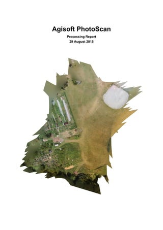
The document summarizes the results of processing photos taken from a drone survey. 40 images were taken covering an area of 0.0157831 square kilometers at a ground resolution of 0.0107865 meters per pixel. Over 2,800 tie points and 17,000 projections were identified with an average reprojection error of 1.94 pixels. Camera calibration information is provided for the PHANTOM VISION FC200 camera used. Average camera location error was estimated to be 11.92 meters based on 7.79 and 8.97 meter errors in the X and Y directions and a 0.96 meter error in the Z direction. A digital elevation model was reconstructed at a resolution of 0.043146 meters per pixel with a
Report
Share
Report
Share
Download to read offline

Recommended
SPICE MODEL of ECKATS471MB , TA=80degree in SPICE PARK
SPICE MODEL of ECKATS471MB , TA=80degree in SPICE PARK. English Version is http://www.spicepark.net.Japanese
Version is http://www.spicepark.com by Bee Technologies.
Le DPP devrait-il être obligatoire en Belgique
Le DPP devrait-il être obligatoire en Belgique. Une enquête PharmaPlanet exclusive auprès des pharmaciens Belges. Résultats nationaux – Enquête réalisée du 1er au 7 décembre 2015
A Ti Mujer
Este poema expresa el gran amor que el autor siente por su esposa Maru. Describe sus sentimientos como un universo y dice que, aunque a veces la hace enojar, él deja salir al niño interior cuando está con ella. El autor pide ser parte del firmamento de Maru y amarla a través de los tiempos, reconociéndola incluso en otra vida por su sonrisa.
Abcnews go com_international_inside_mysterious_underground_c
Archaeologists in Turkey discovered the ruins of an underground city dating back 5,000 years. The discovery was made in December 2014 beneath an area planned for new housing construction in Nevsehir, Turkey. The underground city contains buildings, hidden churches, and water channels. It is believed to be the largest such discovery in the region. Researchers will now study the site to learn more about its history and significance. Debris and items of clothing found at the site suggest it may have been used recently as shelter or for other purposes.
Water pollution 11
A document was submitted by Aneesha V Mohan, who holds a B.Ed in Natural Science. Her registration number at the institution is 18114300003. The document provides her contact information and academic credentials.
2020 Strategy Document_FinalExport_JA
This document outlines the 2020 strategy of Engineers Without Borders Australia. It contains their vision, mission, values, and aims for both external and internal focus over the next 5 years (2015-2020). The external aims are to enable appropriate engineering solutions for social change, redefine the role of engineering, and build a global humanitarian engineering movement. The internal aims are to invest in people, transform systems, grow resources, and increase their profile. The strategy was developed through workshops with members, volunteers, staff and the board to help achieve their vision of everyone having access to engineering knowledge and resources to lead a life free from poverty.
20160823 ww perspektif-baru-energy
This document discusses Indonesia's energy challenges and solutions. It notes that Indonesia has high fuel consumption and is increasingly reliant on imports due to production declines. However, Indonesia has substantial oil and gas reserves that could last over 12 years. The document recommends developing renewable energy sources like geothermal, hydropower, and solar to increase energy independence. It also suggests adopting higher vehicle emission standards to reduce pollution and moving to more sustainable energy can boost the economy. Overall, the document analyzes Indonesia's energy vulnerabilities and proposes developing domestic renewables and cleaner technologies.
Final project report
GM6 has presented beautifully how calibration with flying sensors, height, and instrument leads to have a better Ground sampling distance.
Progress report
"Servicios de Ingeniería", a technology firm based in Mexico, specialized in providing topography, mapping, and engineering services to the Construction, Mining, and Oil & Gas Industry. They are also using drones and satellite imageries to map their client’s assets and to carry out elevation profiling and volume estimation based works.
Econo 2x2
The document is an indoor photometric report for a lighting fixture cataloged as number 1. It provides details on the fixture such as the manufacturer, lamp type, input wattage, luminous opening size and shape, maximum candlepower, zonal lumen distribution, average luminance values at different angles, coefficients of utilization, and a candela distribution table. The report indicates the fixture has an input wattage of 27.2 watts and provides 1892.5 lumens with 92.3% efficiency.
2016_zipp_tool_full_catalogue
The ZIPP GROUP supplies a wide range of professional and industrial air tools. They offer assembly line air tools, automotive service air tools, industrial air tools, and construction air tools. ZIPP GROUP adheres to high quality and safety standards and provides a 1-year warranty on their repair parts and labor. Their air tools include impact wrenches, ratchet wrenches, drills, sanders, grinders, and other products suited for automotive, construction, industrial, and other applications.
2 x 4_econo
The document is an indoor photometric report for a 2x4 LED light fixture containing 96 LED lamps. It provides details on the lamp type and output, fixture dimensions and spacing, light distribution data including maximum candlepower and lumens by zone, average luminance, coefficients of utilization, and a candela table showing candlepower values by angle. The report indicates the fixture distribution is classified as direct and it achieves 92.8% luminaire efficiency.
Eonboom cctv camera New IR LED
2016 NEW Product 4 in 1 cameras, New IR LED 14µ x 12pcs / 14µ x 18pcs Only USD7
Function Introduction
1. Hybird CCTV Camera 4 in 1
2. AHD/CVI/TVI/CVBS signal shift
3.Excellent performance, clear and bright picture with competitive price
4. Option: New IR LED OR Normal IR LED
Miss Michelle
International Sales Dept.
E-mail: michelle@eonboom.com; 2850787256@qq.com
Skype ID:michelle_lai.eonboom
**************************************************************************************************************************************************
Eonboom Electronics Limited
Add: Room 5122,LianMing Commercial Center,No.151 GuangYuanZhong Road,GuangZhou,China
TEL: +86 20 86385228
FAX: +86 20 86385238
Website: www.eonboom.com
1 x4 econo
The document is an indoor photometric report that provides test results for a lighting fixture. It includes details on the fixture catalog number, manufacturer, lamp type, input wattage, luminous opening dimensions, and efficiency. Charts in the report show the zonal lumen summary distribution, average luminance levels at different angles, coefficients of utilization, and candela output values. The report also notes that some vertical and upper hemisphere data are missing.
HCR-A18 4000K Ra73
This document is a test report for an HCR-A18 luminaire with a 4000K, Ra73 light source. It includes photometric test results such as luminous intensity distribution, zonal flux diagrams, and luminance limitation curves. System test details like voltage, current, power factor, and test conditions are provided.
Avtech hdtvi-avt420
This document provides specifications for an AVT420A HD CCTV dome camera that features a 1/2.8" CMOS sensor with 1080p video output, WDR technology, 3-axis mounting, and an infrared effective distance of up to 15 meters. The camera dimensions and additional specifications including megapixels, frame rate, minimum illumination, shutter speed, lens details, and operating temperature are also listed.
50 MM Mega Pixel lens -BalaJi Optics India
50 MM FA/MEGA PIXEL LENS—BALAJI OPTICS INDIA”
BalaJi MicroTechnologies, India is pleased to introduce “50 MM FA/MEGA PIXEL LENS” for wide
range of Factory automation & Machine Vision applications.
With strong in-house R&D & design efforts, we are happy to introduce 50 MM 2/3" imager format Mega-Pixel camera lens series under our brand name "BALAJI OPTICS" A trademark of BalaJi MicroTechnologies. A wholly owned proprietary product range of “BalaJi MicroTechnologies”.
The most crucial quality factor of a lens is its ability to capture clear images through a combination of
resolving power and contrast. BalaJi MicroTechnologies has broad portfolio of Machine Vision lenses
which are designed to provide optimal imaging performance for a wide variety of applications using
CCD/CMOS imaging sensors. Our FA/Machine Vision lenses are designed and built using modern
technologies and precision manufacturing techniques, thus produce images with superb contrast trusted
by clients from all over the industry.
Model No.: BMT-1850D
Brief Technical Review : 1.5 MP Mega Pixel Lens 50 MM Focal Length F# 1.8, 2/3” Format,
C-Mount, Manual Iris
Key Features:
1) High Resolution and High Contrast
2) Low Distortion
3) Bright Images
4) Highly Compact & very cost effective
For More Enquiry,Drop an email to
Sales@balaji-microtechnologies.com
Tel # 0129-6561300, 4006203
50 MM Mega Pixel Machine Vision lens -BalaJi Optics India
50 MM FA/MEGA PIXEL LENS—BALAJI OPTICS INDIA”
BalaJi MicroTechnologies, India is pleased to introduce “50 MM FA/MEGA PIXEL LENS” for wide range of Factory automation & Machine Vision applications.
With strong in-house R&D & design efforts, we are happy to introduce 50 MM 2/3" imager format Mega-Pixel camera lens series under our brand name "BALAJI OPTICS" A trademark of BalaJi MicroTechnologies. A wholly owned proprietary product range of “BalaJi MicroTechnologies”.
The most crucial quality factor of a lens is its ability to capture clear images through a combination of resolving power and contrast. BalaJi MicroTechnologies has broad portfolio of Machine Vision lenses which are designed to provide optimal imaging performance for a wide variety of applications using CCD/CMOS imaging sensors. Our FA/Machine Vision lenses are designed and built using modern technologies and precision manufacturing techniques, thus produce images with superb contrast trusted
by clients from all over the industry.
Model No.: BMT-1850D
Brief Technical Review : 1.5 MP Mega Pixel Lens 50 MM Focal Length F# 1.8, 2/3” Format, C-Mount, Manual Iris
Key Features:
1) High Resolution and High Contrast
2) Low Distortion
3) Bright Images
4) Highly Compact & very cost effective
For More Enquiry,Drop an email to
sales@balaji-microtechnologies.com
Tel # 0129--6561300, 4006203
20 x 60_econo
The document is an indoor photometric report for a lighting fixture cataloged as number 1. It provides details on the fixture such as the manufacturer, lamp type, input wattage, luminous opening, and maximum candlepower distribution. Charts in the report show the lumen output distribution across zones, average luminance at different angles, and coefficients of utilization for various cavity reflectances.
Fujifilm fine pix hs50exr camera
The Fujifilm FinePix HS50EXR digital camera is available from Tiptop Electronics for £245 with fast shipping. It has a 16 megapixel sensor, EXR Processor II for high quality images up to ISO 12800, and a 42x optical zoom lens equivalent to 24-1000mm. The camera also features phase-detection autofocus and full HD video recording with continuous autofocus.
Tarea11: Plan de toma terrestre
The National Institute of Cultural Heritage (INPC) has requested the development of a scale 1:500 plan of the facade of the Church of the Company of Jesus in Quito, Ecuador to document its architectural features and address deterioration from weathering. As the technical director of the project, the document requests the design plan for the photogrammetric project, including the scale of the plan, smallest detail size, camera scale and distance, number of photos, and preliminary budget and schedule. It then provides the camera specifications, calculations for two focal length cases, and a project planning table.
Fred Martin Imaging Portfolio2
This document contains a portfolio of images taken by Fred Martin for various biology projects. It includes over 50 microscope images of specimens such as C. elegans, plant tissues, cells and buccal cells. The images were taken using different microscopes, filters, objectives and techniques such as brightfield, fluorescence, confocal, DIC and stitching. Accompanying each image is metadata on the microscope, specimen, technique and settings used.
Volvo EC60C Compact Excavator Service Repair Manual.pdf
This document provides information about product plates located on various components of a construction excavator. It describes the location and information contained on plates for the machine as a whole, the engine, attachment quick coupler, bucket, and cab. Standard tightening torques for screws and nuts are also included in tables at the end.
Volvo ec60 c compact excavator service repair manual
This document provides information about product plates located on various components of a construction excavator. It describes the location and information contained on plates for the machine as a whole, the engine, attachment quick coupler, bucket, and cab. Standard tightening torques for screws and nuts are also included in tables at the end.
Volvo EC60C Compact Excavator Service Repair Manual.pdf
This document provides information about product plates located on various components of a construction excavator. It describes the location and information contained on plates for the machine as a whole, the engine, attachment quick coupler, bucket, and cab. Standard tightening torques for screws and nuts are also included in tables at the end.
Volvo EC55C Compact Excavator Service Repair Manual.pdf
This document provides information about product plates, component locations, measurement conversion tables, tightening torque specifications, and standard tightening torques for a construction excavator. It includes illustrations and descriptions of the product identification plate, supplementary PIN plate, cab identification plate, engine identification plate, and the locations of major components. Conversion tables are provided for length, area, volume, weight, pressure, and other units. Tightening torque values are listed for specific components and standard torque values are given for various screw sizes.
More Related Content
Similar to pgyu
Final project report
GM6 has presented beautifully how calibration with flying sensors, height, and instrument leads to have a better Ground sampling distance.
Progress report
"Servicios de Ingeniería", a technology firm based in Mexico, specialized in providing topography, mapping, and engineering services to the Construction, Mining, and Oil & Gas Industry. They are also using drones and satellite imageries to map their client’s assets and to carry out elevation profiling and volume estimation based works.
Econo 2x2
The document is an indoor photometric report for a lighting fixture cataloged as number 1. It provides details on the fixture such as the manufacturer, lamp type, input wattage, luminous opening size and shape, maximum candlepower, zonal lumen distribution, average luminance values at different angles, coefficients of utilization, and a candela distribution table. The report indicates the fixture has an input wattage of 27.2 watts and provides 1892.5 lumens with 92.3% efficiency.
2016_zipp_tool_full_catalogue
The ZIPP GROUP supplies a wide range of professional and industrial air tools. They offer assembly line air tools, automotive service air tools, industrial air tools, and construction air tools. ZIPP GROUP adheres to high quality and safety standards and provides a 1-year warranty on their repair parts and labor. Their air tools include impact wrenches, ratchet wrenches, drills, sanders, grinders, and other products suited for automotive, construction, industrial, and other applications.
2 x 4_econo
The document is an indoor photometric report for a 2x4 LED light fixture containing 96 LED lamps. It provides details on the lamp type and output, fixture dimensions and spacing, light distribution data including maximum candlepower and lumens by zone, average luminance, coefficients of utilization, and a candela table showing candlepower values by angle. The report indicates the fixture distribution is classified as direct and it achieves 92.8% luminaire efficiency.
Eonboom cctv camera New IR LED
2016 NEW Product 4 in 1 cameras, New IR LED 14µ x 12pcs / 14µ x 18pcs Only USD7
Function Introduction
1. Hybird CCTV Camera 4 in 1
2. AHD/CVI/TVI/CVBS signal shift
3.Excellent performance, clear and bright picture with competitive price
4. Option: New IR LED OR Normal IR LED
Miss Michelle
International Sales Dept.
E-mail: michelle@eonboom.com; 2850787256@qq.com
Skype ID:michelle_lai.eonboom
**************************************************************************************************************************************************
Eonboom Electronics Limited
Add: Room 5122,LianMing Commercial Center,No.151 GuangYuanZhong Road,GuangZhou,China
TEL: +86 20 86385228
FAX: +86 20 86385238
Website: www.eonboom.com
1 x4 econo
The document is an indoor photometric report that provides test results for a lighting fixture. It includes details on the fixture catalog number, manufacturer, lamp type, input wattage, luminous opening dimensions, and efficiency. Charts in the report show the zonal lumen summary distribution, average luminance levels at different angles, coefficients of utilization, and candela output values. The report also notes that some vertical and upper hemisphere data are missing.
HCR-A18 4000K Ra73
This document is a test report for an HCR-A18 luminaire with a 4000K, Ra73 light source. It includes photometric test results such as luminous intensity distribution, zonal flux diagrams, and luminance limitation curves. System test details like voltage, current, power factor, and test conditions are provided.
Avtech hdtvi-avt420
This document provides specifications for an AVT420A HD CCTV dome camera that features a 1/2.8" CMOS sensor with 1080p video output, WDR technology, 3-axis mounting, and an infrared effective distance of up to 15 meters. The camera dimensions and additional specifications including megapixels, frame rate, minimum illumination, shutter speed, lens details, and operating temperature are also listed.
50 MM Mega Pixel lens -BalaJi Optics India
50 MM FA/MEGA PIXEL LENS—BALAJI OPTICS INDIA”
BalaJi MicroTechnologies, India is pleased to introduce “50 MM FA/MEGA PIXEL LENS” for wide
range of Factory automation & Machine Vision applications.
With strong in-house R&D & design efforts, we are happy to introduce 50 MM 2/3" imager format Mega-Pixel camera lens series under our brand name "BALAJI OPTICS" A trademark of BalaJi MicroTechnologies. A wholly owned proprietary product range of “BalaJi MicroTechnologies”.
The most crucial quality factor of a lens is its ability to capture clear images through a combination of
resolving power and contrast. BalaJi MicroTechnologies has broad portfolio of Machine Vision lenses
which are designed to provide optimal imaging performance for a wide variety of applications using
CCD/CMOS imaging sensors. Our FA/Machine Vision lenses are designed and built using modern
technologies and precision manufacturing techniques, thus produce images with superb contrast trusted
by clients from all over the industry.
Model No.: BMT-1850D
Brief Technical Review : 1.5 MP Mega Pixel Lens 50 MM Focal Length F# 1.8, 2/3” Format,
C-Mount, Manual Iris
Key Features:
1) High Resolution and High Contrast
2) Low Distortion
3) Bright Images
4) Highly Compact & very cost effective
For More Enquiry,Drop an email to
Sales@balaji-microtechnologies.com
Tel # 0129-6561300, 4006203
50 MM Mega Pixel Machine Vision lens -BalaJi Optics India
50 MM FA/MEGA PIXEL LENS—BALAJI OPTICS INDIA”
BalaJi MicroTechnologies, India is pleased to introduce “50 MM FA/MEGA PIXEL LENS” for wide range of Factory automation & Machine Vision applications.
With strong in-house R&D & design efforts, we are happy to introduce 50 MM 2/3" imager format Mega-Pixel camera lens series under our brand name "BALAJI OPTICS" A trademark of BalaJi MicroTechnologies. A wholly owned proprietary product range of “BalaJi MicroTechnologies”.
The most crucial quality factor of a lens is its ability to capture clear images through a combination of resolving power and contrast. BalaJi MicroTechnologies has broad portfolio of Machine Vision lenses which are designed to provide optimal imaging performance for a wide variety of applications using CCD/CMOS imaging sensors. Our FA/Machine Vision lenses are designed and built using modern technologies and precision manufacturing techniques, thus produce images with superb contrast trusted
by clients from all over the industry.
Model No.: BMT-1850D
Brief Technical Review : 1.5 MP Mega Pixel Lens 50 MM Focal Length F# 1.8, 2/3” Format, C-Mount, Manual Iris
Key Features:
1) High Resolution and High Contrast
2) Low Distortion
3) Bright Images
4) Highly Compact & very cost effective
For More Enquiry,Drop an email to
sales@balaji-microtechnologies.com
Tel # 0129--6561300, 4006203
20 x 60_econo
The document is an indoor photometric report for a lighting fixture cataloged as number 1. It provides details on the fixture such as the manufacturer, lamp type, input wattage, luminous opening, and maximum candlepower distribution. Charts in the report show the lumen output distribution across zones, average luminance at different angles, and coefficients of utilization for various cavity reflectances.
Fujifilm fine pix hs50exr camera
The Fujifilm FinePix HS50EXR digital camera is available from Tiptop Electronics for £245 with fast shipping. It has a 16 megapixel sensor, EXR Processor II for high quality images up to ISO 12800, and a 42x optical zoom lens equivalent to 24-1000mm. The camera also features phase-detection autofocus and full HD video recording with continuous autofocus.
Tarea11: Plan de toma terrestre
The National Institute of Cultural Heritage (INPC) has requested the development of a scale 1:500 plan of the facade of the Church of the Company of Jesus in Quito, Ecuador to document its architectural features and address deterioration from weathering. As the technical director of the project, the document requests the design plan for the photogrammetric project, including the scale of the plan, smallest detail size, camera scale and distance, number of photos, and preliminary budget and schedule. It then provides the camera specifications, calculations for two focal length cases, and a project planning table.
Fred Martin Imaging Portfolio2
This document contains a portfolio of images taken by Fred Martin for various biology projects. It includes over 50 microscope images of specimens such as C. elegans, plant tissues, cells and buccal cells. The images were taken using different microscopes, filters, objectives and techniques such as brightfield, fluorescence, confocal, DIC and stitching. Accompanying each image is metadata on the microscope, specimen, technique and settings used.
Volvo EC60C Compact Excavator Service Repair Manual.pdf
This document provides information about product plates located on various components of a construction excavator. It describes the location and information contained on plates for the machine as a whole, the engine, attachment quick coupler, bucket, and cab. Standard tightening torques for screws and nuts are also included in tables at the end.
Volvo EC60C Compact Excavator Service Repair Manual.pdf
This document provides information about product plates located on various components of a construction excavator. It describes the location and information contained on plates for the machine as a whole, the engine, attachment quick coupler, bucket, and cab. Standard tightening torques for screws and nuts are also included in tables at the end.
Volvo ec60 c compact excavator service repair manual
This document provides information about product plates located on various components of a construction excavator. It describes the location and information contained on plates for the machine as a whole, the engine, attachment quick coupler, bucket, and cab. Standard tightening torques for screws and nuts are also included in tables at the end.
Volvo EC60C Compact Excavator Service Repair Manual.pdf
This document provides information about product plates located on various components of a construction excavator. It describes the location and information contained on plates for the machine as a whole, the engine, attachment quick coupler, bucket, and cab. Standard tightening torques for screws and nuts are also included in tables at the end.
Volvo EC55C Compact Excavator Service Repair Manual.pdf
This document provides information about product plates, component locations, measurement conversion tables, tightening torque specifications, and standard tightening torques for a construction excavator. It includes illustrations and descriptions of the product identification plate, supplementary PIN plate, cab identification plate, engine identification plate, and the locations of major components. Conversion tables are provided for length, area, volume, weight, pressure, and other units. Tightening torque values are listed for specific components and standard torque values are given for various screw sizes.
Similar to pgyu (20)
50 MM Mega Pixel Machine Vision lens -BalaJi Optics India
50 MM Mega Pixel Machine Vision lens -BalaJi Optics India
Volvo EC60C Compact Excavator Service Repair Manual.pdf
Volvo EC60C Compact Excavator Service Repair Manual.pdf
Volvo EC60C Compact Excavator Service Repair Manual.pdf
Volvo EC60C Compact Excavator Service Repair Manual.pdf
Volvo ec60 c compact excavator service repair manual
Volvo ec60 c compact excavator service repair manual
Volvo EC60C Compact Excavator Service Repair Manual.pdf
Volvo EC60C Compact Excavator Service Repair Manual.pdf
Volvo EC55C Compact Excavator Service Repair Manual.pdf
Volvo EC55C Compact Excavator Service Repair Manual.pdf
pgyu
- 1. Agisoft PhotoScan Processing Report 29 August 2015
- 2. Survey Data 1 2 3 4 5 6 7 8 9 > 9 Fig. 1. Camera locations and image overlap. Number of images: 40 Flying altitude: 32.3764 m Ground resolution: 0.0107865 m/pix Coverage area: 0.0157831 sq km Camera stations: 40 Tie-points: 2806 Projections: 17029 Error: 1.93566 pix Camera Model Resolution Focal Length Pixel Size Precalibrated PHANTOM VISION FC200 (5 mm) 4608 x 3456 5 mm 1.34135 x 1.34135 um Yes Table. 1. Cameras.
- 3. Camera Calibration 2 pix Fig. 2. Image residuals for PHANTOM VISION FC200 (5 mm). PHANTOM VISION FC200 (5 mm) Type: Fisheye Fx: 2253.58 Fy: 2258.69 Cx: 2328.19 Cy: 1664.62 Skew: 1.37561 K1: 0.0378349 K2: -0.0173169 K3: 0.000354266 K4: -0.000958676 P1: -0.000317342 P2: 5.80709e-005
- 4. Camera Locations -1.83617 m -1.46893 m -1.1017 m -0.734466 m -0.367233 m 0 m 0.367233 m 0.734466 m 1.1017 m 1.46893 m 1.83617 m Fig. 3. Camera locations and error estimates. Z error is represented by ellipse color. X,Y errors are represented by ellipse shape. Estimated camera locations are marked with a black dot. X error (m) Y error (m) Z error (m) Total error (m) 7.792377 8.967124 0.964523 11.918925 Table. 2. Average camera location error.
- 5. Digital Elevation Model -30.248 m -16.2159 m Fig. 4. Reconstructed digital elevation model. Resolution: 0.043146 m/pix Point density: 537.179 points per sq m