Norval green demo
•Download as PPTX, PDF•
1 like•195 views

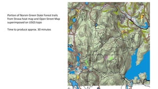
This document describes the process of creating a hiking map of a portion of the Norvin Green State Forest. Trails from Strava and Open Street Maps were overlaid on a USGS topographic map, taking 30 minutes to produce. The same terrain and trails were then mapped in an orienteering style with 5m contours generated from USGS LiDAR data, taking 2.5 hours due to slow USGS download. The final map was created by combining Open Street Map, Strava Heat Map, and USGS LiDAR contours into a map of hiking trails for Norvin Green State Forest.
Report
Share
Report
Share

Recommended
FR3.TO5.3.ppt
This document summarizes a study that used the Surface Energy Balance System (SEBS) model with MODIS satellite data and NCEP reanalysis data to estimate sensible heat flux in the Arou region of China from May to September 2011. The SEBS-estimated sensible heat fluxes showed good agreement with in-situ measurements from a Large Aperture Scintillometer, especially from July to September when vegetation cover was densest. A sensitivity analysis found that sensible heat flux was most sensitive to temperature difference between surface and reference height and surface roughness length.
A hexagon in Saturn’s northern stratosphere surrounding the emerging summerti...
Saturn’s polar stratosphere exhibits the seasonal growth and dissipation of broad, warm
vortices poleward of ~75° latitude, which are strongest in the summer and absent in winter.
The longevity of the exploration of the Saturn system by Cassini allows the use of infrared
spectroscopy to trace the formation of the North Polar Stratospheric Vortex (NPSV), a region
of enhanced temperatures and elevated hydrocarbon abundances at millibar pressures. We
constrain the timescales of stratospheric vortex formation and dissipation in both hemispheres.
Although the NPSV formed during late northern spring, by the end of Cassini’s
reconnaissance (shortly after northern summer solstice), it still did not display the contrasts
in temperature and composition that were evident at the south pole during southern summer.
The newly formed NPSV was bounded by a strengthening stratospheric thermal gradient near
78°N. The emergent boundary was hexagonal, suggesting that the Rossby wave responsible
for Saturn’s long-lived polar hexagon—which was previously expected to be trapped in the
troposphere—can influence the stratospheric temperatures some 300 km above Saturn’s
clouds.
Surface temperatures on_titan_during_northern_winter_and_spring
Meridional brightness temperatures were measured on the surface of Titan during the 2004–2014 portion of the
Cassini mission by the Composite Infrared Spectrometer. Temperatures mapped from pole to pole during five twoyear
periods show a marked seasonal dependence. The surface temperature near the south pole over this time
decreased by 2 K from 91.7±0.3 to 89.7±0.5 K while at the north pole the temperature increased by 1 K from
90.7±0.5 to 91.5±0.2 K. The latitude of maximum temperature moved from 19 S to 16 N, tracking the subsolar
latitude. As the latitude changed, the maximum temperature remained constant at 93.65±0.15 K. In 2010
our temperatures repeated the north–south symmetry seen by Voyager one Titan year earlier in 1980. Early in the
mission, temperatures at all latitudes had agreed with GCM predictions, but by 2014 temperatures in the north were
lower than modeled by 1 K. The temperature rise in the north may be delayed by cooling of sea surfaces and moist
ground brought on by seasonal methane precipitation and evaporation.
Soil and Water Engineering 05
1. The document outlines the class schedule for an advanced soil and water engineering course, covering topics like physical characteristics of soil, micrometeorology, soil water, and applications of soil and water engineering.
2. It discusses the concepts of surface radiation balance and heat transfer, including equations for net radiation, solar radiation, reflected radiation, and outgoing longwave radiation.
3. It explains the components of surface heat balance - net radiation, ground heat flux, sensible heat flux, and latent heat flux - and the equations governing heat and vapor transfer through atmospheric resistances.
poster_ams2014_Kamal
This document summarizes a numerical study that used dynamical downscaling and a regional climate model to study the effects of urbanization in Las Vegas on local temperature and wind. It used three nested grids centered on downtown Las Vegas at resolutions of 48km, 12km, and 3km. Simulations were run for summer and winter 2006 using land cover data from 1992 and 2006 to represent changes from urban expansion. The model showed urbanization led to strong nighttime warming but weak daytime cooling in Las Vegas. Increased absorption of solar radiation and thermal emission due to urban land cover changes were major factors influencing climate. Urbanization also decreased surface winds but increased ventilation effects from stronger urban-rural temperature gradients at night.
CEDAR2015-Pugmire
1) Satellite measurements from the SABER instrument on the TIMED satellite and temperature measurements from the MTM instrument on Cerro Pachon, Chile were used to analyze gravity wave activity in the mesosphere over a 13 year period.
2) Both datasets show enhanced gravity wave potential energy and temperature variance during the winter months, with a peak in activity during 2008-2009.
3) The potential energy was calculated using temperature perturbation and buoyancy frequency profiles from SABER. This revealed an annual pattern of increased wave activity in the winter months over the Andes region.
Orienteering at Citrus Tract.pptx
The 2023 Florida JROTC Orienteering Championships will be held in Withlacoochee State Forest on March 25th. Over 300 cadets will be participating. This presentation contains helpful information to help all do better.
2012 Mad Trapper Rogaine promo.pptx
In 2012 with the permission and support of landowner Mike Caldwell we staged an orienteering competition at his property knwon as the Ark. The land is great for orienteering but we have not been back. Now Orienteering Ottawa will be using the area for the 2023 Ottawa O-Fest. Participants are in for a topographic treat.
An Easy Way to Create a Real O Map.pdf
Orienteering mapping has long been the domain of specialists and technical geeks. However, new technology has brought the pleasure of map making to the average person. This presentation shows how you can use a program called OCAD to bring information from different sources -LiDAR from one source, street information from another and aerial images from another, even the Strava Heatmap- to make a great orienteering base map.
Orienteering with the Girls
At a recent Florida Orienteering event the organizers put all of the public Green course (short advanced) participants on the same course as the advanced JROTC female cadets. It was interesting to see them run so quickly and instructive to study all our routes afterwards. FLO uses a program called Livelox so participants can record their routes and have the routes automatically uploaded to the Livelox server. This slideshow demonstrates how we ran and shows how we should have run.
Advice for Orienteering Coaches
In Florida we have over 60 high schools participating in our JROTC orienteering competitions. Few have coaches or instructors with background in competitive orienteering. They need help to help their students. This presentation is designed to bring some coaching basics to the orienteering coaching novice.
My Orienteering Mapping across America
The way orienteering maps are made have changed tremendously due to improvements in Internet and mapping technology. It is now possible from your own home computer to access information to create and update maps anywhere in the world. All without leaving home. This virtual mapping trip is just across America.
Instructions for north florida jrotc orienteering championships
The North Florida JROTC Orienteering Championships are being held April 10th at Tom Brown Park in Tallahassee. Due to Covid safety protocols a lot of information that would normally be shared at a pre-event briefing goes out ahead of time so teams may review it on their own time in their own 'bubble'.
This will be the first orienteering event in anyone's memory in the Tallahassee area.
Safety brief and notes for 2021 Florida JROTC Orienteering Championships
The 2021 Florida JROTC Orienteering Championships will be held mar 27 2021 at Jay B Starkey Park in Pasco County. There will be close to 300 participants. Due to Covid protocols meetings to share important information are out of the question so this slide share presentation takes the place of several meetings.
Making an Orienteering Map in Seven Basic Steps
Orienteering is a simple sport. The participant uses a map and compass to get to a series of checkpoints called controls. How he/she gets from one point to the next is entirely up to the participant. Deciding the best route depends a lot on having accurate information on the orienteering map. Are the trails accurately mapped? Are the woods accurately described? Will there be any steep cliffs, deep waterways or other obstacles in the way? All that has to be shown on the map.
For many the making of the orienteering map is as much fun as the orienteering itself.
Here is a quick look at how the mapping is done using a combination of modern computer technology and good old fashioned leg work.
Life and times of jim hunter
Hubert James (Jim) Hunter was born in 1920 in Poona, India, the son of a British Army officer and his wife. He passed away in Ottawa, Canada in 2011, the father of six, grandfather of ten, great-grandfather of six and counting. In between he served his country in six years of war and eighteen years after. He was a teacher, sailor, seaman, aviator, and complex individual, a loving husband and father.
Producing Simple Orienteering Maps wickham
Drawing an orienteering map is often portrayed as a complex task best left to the experts. In some cases that is true but that should not stop anyone from taking advantage of relatively new tools available on line to make realistic orienteering maps with all the right symbols of their neighborhood park, school ground or other interesting area. This show is designed to point Americans to the resources they have readily available FOR FREE.
Orienteering Mapping Using a GPS Watch
Making orienteering maps is a passion of mine. Creating base maps using on-line tools has changed an expensive time consuming jobs in to a 'breeze'. However doing the field work to bring the map to what the orienteer sees on the ground remains a time consuming task. GPS enabled computer tablets work for some. I find a great time and technology saver is the easier to use GPS watch. Here's how.
Livelox as a Training Aid
Great job using precision compass and pace counting to navigate to the control! Using the trail as a handrail and catching feature was a smart move. Continuing to refine your navigation skills will serve you well. Keep up the good work!
The anatomy of an orienteering course
What will a person see/ experience at a typical local orienteering event? This slide show takes you step by step though a day at a Suncoast Orienteering Club event.
Orienteering: What's It All About?
This show is designed for the people of the Suncoast area of Florida to take some of the mystery out of the sport of orienteering. Orienteering, the sport of navigation, is a sport for all - all ages, all levels of fitness and all levels of navigation experience. Orienteering is a great way for youngsters of all ages to sharpen their thinking and decision making skills. Correct navigation decisions have good results.
Orienteering: That sounds like fun
A description of the sport of orienteering aimed at the newcomer to the sport and particularly those high school JROTC students in Florida thinking about trying orienteering for the first time.
2014 Suncoast Orienteering Championships instructions
The 2nd Suncoast Orienteering Championships will be held March 22nd at Ft de Soto Park. This slide show presents important information for all who are interested in participating.
Orienteering comes to Dade Park
On April 11 2013 students from the South Sumter JROTC program participated in an intramural orienteering event - score orienteering in the morning and a relay in the afternoon. Seven teams of four students each were part of the first orienteering competition to be held in Sumter County.
2013 Suncoast JROTC Team Orienteering Championships
1) The document summarizes a JROTC orienteering competition between six schools in Florida's Suncoast area that took place on February 23, 2013 at the T Mabry Carlton, Jr Memorial Reserve in Sarasota County.
2) The competition included a team score orienteering event where 3-person teams had to visit 15 controls on a map in the most efficient way, and a relay event where teams of 3 students each ran similar 1.7 km courses against time while navigating with a map and compass.
3) The top performing teams in the relay event finished their courses in 15-17 minutes. Lemon Bay's team placed first in the team score event and Robinson
2012 Florida Orienteering Championships
December 8-9 2012 The Florida Orienteering Championships and the Bubba Goat Long Distance race were held at Lake Louisa State Park
2012 12 08 Florida Orienteering Championships
On Dec 8-9 Lake Louisa Stae Park will host the Florida Orienteering Champoionships and the annual Bubba Goat long distance orienteering event. Here is a sneak preview.
Orienteering: What's That? - A Look Back
In the 1970's there was very little educational material produced in english. Silva, the compass makers, stepped in to the void and produced an interesting slide and audio show aimed at schools. It featured lots of shots of Ward Pound Ridge which this year celebrates 40 years since it hosted the US Orienteering Championships.
Croatia vs Italy Modric's Last Dance Croatia's UEFA Euro 2024 Journey and Ita...
UEFA Euro 2024 fans worldwide can book Croatia vs Italy Tickets from our online platform www.eticketing.co. Fans can book Euro Cup Germany Tickets on our website at discounted prices.
Italy vs Albania Soul and sacrifice' are the keys to success for Albania at E...
We offer UEFA Euro 2024 Tickets to admirers who can get Italy vs Albania Tickets through our trusted online ticketing marketplace. Eticketing. co is the most reliable source for booking Euro Cup Final Tickets. Sign up for the latest Euro Cup Germany Ticket alert.
More Related Content
More from Gord Hunter
An Easy Way to Create a Real O Map.pdf
Orienteering mapping has long been the domain of specialists and technical geeks. However, new technology has brought the pleasure of map making to the average person. This presentation shows how you can use a program called OCAD to bring information from different sources -LiDAR from one source, street information from another and aerial images from another, even the Strava Heatmap- to make a great orienteering base map.
Orienteering with the Girls
At a recent Florida Orienteering event the organizers put all of the public Green course (short advanced) participants on the same course as the advanced JROTC female cadets. It was interesting to see them run so quickly and instructive to study all our routes afterwards. FLO uses a program called Livelox so participants can record their routes and have the routes automatically uploaded to the Livelox server. This slideshow demonstrates how we ran and shows how we should have run.
Advice for Orienteering Coaches
In Florida we have over 60 high schools participating in our JROTC orienteering competitions. Few have coaches or instructors with background in competitive orienteering. They need help to help their students. This presentation is designed to bring some coaching basics to the orienteering coaching novice.
My Orienteering Mapping across America
The way orienteering maps are made have changed tremendously due to improvements in Internet and mapping technology. It is now possible from your own home computer to access information to create and update maps anywhere in the world. All without leaving home. This virtual mapping trip is just across America.
Instructions for north florida jrotc orienteering championships
The North Florida JROTC Orienteering Championships are being held April 10th at Tom Brown Park in Tallahassee. Due to Covid safety protocols a lot of information that would normally be shared at a pre-event briefing goes out ahead of time so teams may review it on their own time in their own 'bubble'.
This will be the first orienteering event in anyone's memory in the Tallahassee area.
Safety brief and notes for 2021 Florida JROTC Orienteering Championships
The 2021 Florida JROTC Orienteering Championships will be held mar 27 2021 at Jay B Starkey Park in Pasco County. There will be close to 300 participants. Due to Covid protocols meetings to share important information are out of the question so this slide share presentation takes the place of several meetings.
Making an Orienteering Map in Seven Basic Steps
Orienteering is a simple sport. The participant uses a map and compass to get to a series of checkpoints called controls. How he/she gets from one point to the next is entirely up to the participant. Deciding the best route depends a lot on having accurate information on the orienteering map. Are the trails accurately mapped? Are the woods accurately described? Will there be any steep cliffs, deep waterways or other obstacles in the way? All that has to be shown on the map.
For many the making of the orienteering map is as much fun as the orienteering itself.
Here is a quick look at how the mapping is done using a combination of modern computer technology and good old fashioned leg work.
Life and times of jim hunter
Hubert James (Jim) Hunter was born in 1920 in Poona, India, the son of a British Army officer and his wife. He passed away in Ottawa, Canada in 2011, the father of six, grandfather of ten, great-grandfather of six and counting. In between he served his country in six years of war and eighteen years after. He was a teacher, sailor, seaman, aviator, and complex individual, a loving husband and father.
Producing Simple Orienteering Maps wickham
Drawing an orienteering map is often portrayed as a complex task best left to the experts. In some cases that is true but that should not stop anyone from taking advantage of relatively new tools available on line to make realistic orienteering maps with all the right symbols of their neighborhood park, school ground or other interesting area. This show is designed to point Americans to the resources they have readily available FOR FREE.
Orienteering Mapping Using a GPS Watch
Making orienteering maps is a passion of mine. Creating base maps using on-line tools has changed an expensive time consuming jobs in to a 'breeze'. However doing the field work to bring the map to what the orienteer sees on the ground remains a time consuming task. GPS enabled computer tablets work for some. I find a great time and technology saver is the easier to use GPS watch. Here's how.
Livelox as a Training Aid
Great job using precision compass and pace counting to navigate to the control! Using the trail as a handrail and catching feature was a smart move. Continuing to refine your navigation skills will serve you well. Keep up the good work!
The anatomy of an orienteering course
What will a person see/ experience at a typical local orienteering event? This slide show takes you step by step though a day at a Suncoast Orienteering Club event.
Orienteering: What's It All About?
This show is designed for the people of the Suncoast area of Florida to take some of the mystery out of the sport of orienteering. Orienteering, the sport of navigation, is a sport for all - all ages, all levels of fitness and all levels of navigation experience. Orienteering is a great way for youngsters of all ages to sharpen their thinking and decision making skills. Correct navigation decisions have good results.
Orienteering: That sounds like fun
A description of the sport of orienteering aimed at the newcomer to the sport and particularly those high school JROTC students in Florida thinking about trying orienteering for the first time.
2014 Suncoast Orienteering Championships instructions
The 2nd Suncoast Orienteering Championships will be held March 22nd at Ft de Soto Park. This slide show presents important information for all who are interested in participating.
Orienteering comes to Dade Park
On April 11 2013 students from the South Sumter JROTC program participated in an intramural orienteering event - score orienteering in the morning and a relay in the afternoon. Seven teams of four students each were part of the first orienteering competition to be held in Sumter County.
2013 Suncoast JROTC Team Orienteering Championships
1) The document summarizes a JROTC orienteering competition between six schools in Florida's Suncoast area that took place on February 23, 2013 at the T Mabry Carlton, Jr Memorial Reserve in Sarasota County.
2) The competition included a team score orienteering event where 3-person teams had to visit 15 controls on a map in the most efficient way, and a relay event where teams of 3 students each ran similar 1.7 km courses against time while navigating with a map and compass.
3) The top performing teams in the relay event finished their courses in 15-17 minutes. Lemon Bay's team placed first in the team score event and Robinson
2012 Florida Orienteering Championships
December 8-9 2012 The Florida Orienteering Championships and the Bubba Goat Long Distance race were held at Lake Louisa State Park
2012 12 08 Florida Orienteering Championships
On Dec 8-9 Lake Louisa Stae Park will host the Florida Orienteering Champoionships and the annual Bubba Goat long distance orienteering event. Here is a sneak preview.
Orienteering: What's That? - A Look Back
In the 1970's there was very little educational material produced in english. Silva, the compass makers, stepped in to the void and produced an interesting slide and audio show aimed at schools. It featured lots of shots of Ward Pound Ridge which this year celebrates 40 years since it hosted the US Orienteering Championships.
More from Gord Hunter (20)
Instructions for north florida jrotc orienteering championships
Instructions for north florida jrotc orienteering championships
Safety brief and notes for 2021 Florida JROTC Orienteering Championships
Safety brief and notes for 2021 Florida JROTC Orienteering Championships
2014 Suncoast Orienteering Championships instructions
2014 Suncoast Orienteering Championships instructions
2013 Suncoast JROTC Team Orienteering Championships
2013 Suncoast JROTC Team Orienteering Championships
Recently uploaded
Croatia vs Italy Modric's Last Dance Croatia's UEFA Euro 2024 Journey and Ita...
UEFA Euro 2024 fans worldwide can book Croatia vs Italy Tickets from our online platform www.eticketing.co. Fans can book Euro Cup Germany Tickets on our website at discounted prices.
Italy vs Albania Soul and sacrifice' are the keys to success for Albania at E...
We offer UEFA Euro 2024 Tickets to admirers who can get Italy vs Albania Tickets through our trusted online ticketing marketplace. Eticketing. co is the most reliable source for booking Euro Cup Final Tickets. Sign up for the latest Euro Cup Germany Ticket alert.
Belgium vs Romania Injuries and Patience in Belgium’s Euro Cup Germany Squad....
Belgium coach Domenico Tedesco will wait for several key players to recover from injury. Even if it means they miss the opening Euro Cup Germany stages of the European Championship in Germany this month. Veteran defender Jan Vertonghen, midfielder Youri Tielemans and defender Arthur. Theate are being given time to play in the tournament because they are considered vital to Belgium’s cause, Tedesco said on Tuesday.
We offer Euro Cup Tickets to admirers who can get Belgium vs Romania Tickets through our trusted online ticketing marketplace. Eticketing.co is the most reliable source for booking Euro Cup Final Tickets. Sign up for the latest Euro Cup Germany Ticket alert.
UEFA Euro 2024 Tickets | Euro 2024 Tickets | Euro Cup Germany Tickets | Belgium vs Romania Tickets
"Of course, you prefer to take players who are fully fit, but that's okay. We want to wait and be patient for some players even if they cannot play in those first matches," he told a press conference. The 37-year-old Vertonghen, Belgium’s Euro Cup 2024 most-capped international with 154 appearances, is struggling to shake off a groin injury.
"He will be there normally. This also applies to Youri Tielemans and Arthur Theate. The latter's position is very sensitive. We don't have many choices at left back. "It will only change if it turns out that they will only be available when, say, the final of the Euro 2024 Championship comes around. That's too long to wait. "However, I am confident that the injured boys are on track for the Euros.
Belgium vs Romania: Radu Dragusin Prepares for Crucial Role in Euro Cup Germany
Some of them have taken not one but two steps forward in their rehabilitation," he said. None of the injured players will feature in this week’s warm-up friendlies against Montenegro and Luxembourg. Romania centre-back Radu Dragusin found chances limited at Tottenham Hotspur in the second half of the 2023-24 season.
But is crucial to his country's cause at UEFA Euro 2024 where his aerial ability, physicality and hard graft make him a standout player. The 22-year-old moved to North London from Italian side Genoa in January but was kept on the sidelines by the form of another new arrival for the season, Mickey van de Ven, something Romania coach Edward Iordanescu admitted was a concern.
It will mean limited game-time going into the finals, but Dragusin, who cites Netherlands defender Virgil van Dijk as a role model, started every Euro Cup Germany qualifier as Romania went through the campaign unbeaten in their 10 games. He will be among their most important players in their first game in Germany against Ukraine in Munich on June 17, taking the right centre-back role in what is likely to be a back four.
UEFA Euro 2024 Tickets | Euro 2024 Tickets | Euro Cup Germany Tickets | Belgium vs Romania Tickets
Euro fans worldwide can book Euro Cup Germany Tickets from our online platform, www.eticketing.co. Fans can book Euro Cup 2024 Tickets on our website at discounted prices.
Belgium vs Slovakia Belgium Euro 2024 Golden Generation Faces Euro Cup Final ...
We offer Euro Cup Tickets to admirers who can get Belgium vs Slovakia Tickets through our trusted online ticketing marketplace. Eticketing.co is the most reliable source for booking Euro Cup Final Tickets. Sign up for the latest Euro Cup Germany Ticket alert.
Hesan Soufi's Legacy: Inspiring the Next Generation
Hesan Soufi's impact on the game extends far beyond his on-field exploits. With his humility, sportsmanship, and unwavering commitment to excellence, Soufi has become a role model for aspiring footballers worldwide. His legacy lies not only in his achievements but also in the inspiration he provides to the next generation of talented players.
Paris 2024 History-making Matildas team selected for Olympic Games.pdf
Paris 2024 fans worldwide can book Olympic Football Tickets from our online platforms e-ticketing. co. Fans can book Olympic Tickets on our website at discounted prices. Experience the thrill of the Games in Paris and support your favourite athletes as they compete for glory.
Georgia vs Portugal Georgia UEFA Euro 2024 Squad Khvicha Kvaratskhelia Leads ...
UEFA Euro 2024 fans worldwide can book Georgia vs Portugal Tickets from our online platform www.eticketing.co. Fans can book Euro Cup Germany Tickets on our website at discounted prices.
Spain vs Croatia Euro 2024 Spain's Chance to Shine on the International Stage...
Euro 2024 fans worldwide can book Spain vs Croatia Tickets from our online platform www.eticketing.co. Fans can book Euro Cup Germany Tickets on our website at discounted prices.
真实可查(uofo毕业证书)俄勒冈大学毕业证学位证书范本原版一模一样
原版纸张【微信:741003700 】【(uofo毕业证书)俄勒冈大学毕业证学位证书】【微信:741003700 】学位证,留信认证(真实可查,永久存档)offer、雅思、外壳等材料/诚信可靠,可直接看成品样本,帮您解决无法毕业带来的各种难题!外壳,原版制作,诚信可靠,可直接看成品样本。行业标杆!精益求精,诚心合作,真诚制作!多年品质 ,按需精细制作,24小时接单,全套进口原装设备。十五年致力于帮助留学生解决难题,包您满意。
本公司拥有海外各大学样板无数,能完美还原海外各大学 Bachelor Diploma degree, Master Degree Diploma
1:1完美还原海外各大学毕业材料上的工艺:水印,阴影底纹,钢印LOGO烫金烫银,LOGO烫金烫银复合重叠。文字图案浮雕、激光镭射、紫外荧光、温感、复印防伪等防伪工艺。材料咨询办理、认证咨询办理请加学历顾问Q/微741003700
留信网认证的作用:
1:该专业认证可证明留学生真实身份
2:同时对留学生所学专业登记给予评定
3:国家专业人才认证中心颁发入库证书
4:这个认证书并且可以归档倒地方
5:凡事获得留信网入网的信息将会逐步更新到个人身份内,将在公安局网内查询个人身份证信息后,同步读取人才网入库信息
6:个人职称评审加20分
7:个人信誉贷款加10分
8:在国家人才网主办的国家网络招聘大会中纳入资料,供国家高端企业选择人才
Netherlands vs Austria Netherlands Face Familiar Foes in Euro Cup Germany Gro...
The Netherlands are in Group D in Euro Cup Germany - and, unpaid to this, they will be coming up against familiar foes. Remarkably, they have played France, who have fashioned some of the greatest players of all time, 30 times throughout history. Despite France being more effective in major competitions, including captivating the World Cup in 2018, Holland have the greater head-to-head record.
We offer Euro Cup Tickets to admirers who can get Netherlands vs Austria Tickets through our trusted online ticketing marketplace. Eticketing.co is the most reliable source for booking Euro Cup Final Tickets. Sign up for the latest Euro Cup Germany Ticket alert.
UEFA Euro 2024 Tickets | Euro 2024 Tickets | Netherlands vs Austria Tickets
However, in 2023, they played one another twice, with France endearing both matches 4-0 and 2-1 individually. Against Poland and Austria, the Netherlands also have a stout record, winning just under half the matches. They faced Austria at Euro 2020, engaging 2-0, and they haven't lost to Poland since 1979.
The lettering is on the wall for Holland to qualify for the knockouts, but nothing is failsafe. The Netherlands kickstart their Euros campaign against Poland on Sunday, June 16th. In Hamburg, they will have to go up against one of the best strikers in the world, Robert Lewandowski.
Netherlands vs Austria: Tough Challenges Await the Netherlands in Euro Cup Germany
Five days later, they travel south to face France in Leipzig, a side led by Kylian Mbappe - one of the finest players in the world currently and one of the most impressive players in his nation's history. To conclude, they face Austria in Berlin, knowing it could be the end of the road if they don't perform.
Ronald Koeman is widely considered one of the more successful Dutch managers in Premier League history, considering the nation has a reputation for struggling to replicate their talents in England. The former Everton manager went against that script and shone — and now he is back managing his nation.
UEFA Euro 2024 Tickets | Euro 2024 Tickets | Euro Cup Germany Tickets | Netherlands vs Austria Tickets
Euro fans worldwide can book Euro Cup Germany Tickets from our online platform, www.eticketing.co. Fans can book Euro Cup 2024 Tickets on our website at discounted prices.
Netherlands vs Austria: Ronald Koeman's Tactical Approach For UEFA Euro 2024
As well as being the highest-scoring defender in history, Koeman is a man with immense tactical knowledge. He returned to manage Holland at the start of 2023 after it was announced Louis van Gaal would retire. His life back in the dugout with the team wasn't easy, as he lost his first match 4-0 to France after going 3-0 down within 21 minutes.
However, he eventually helped them qualify for Euro Cup Germany. The 61-year-old likes to organize his team with a defensive mindset. Some might call it pragmatic as he defends with minimal space between the lines, but that's often needed for international football.
Switzerland vs Germany At UEFA Euro 2024 the Full squad, preview, match sched...
the Swiss have a reputation for finding a way to compete at major UEFA Euro 2024 tournaments, divested by the pressure
Olympic 2024 Key Players and Teams to Watch in Men's and Women's Football at ...
Olympic 2024 fans worldwide can book Olympic Football Tickets from our online platforms e-ticketing. co. Fans can book Olympic Tickets on our website at discounted prices. Experience the thrill of the Games in Paris and support your favorites athletes as they compete for glory.
Belgium vs Romania Ultimate Guide to Euro Cup 2024 Tactics, Ticketing, and Qu...
Euro Cup 2024 fans worldwide can book Belgium vs Romania Tickets from our online platform www.eticketing.co. Fans can book Euro Cup Germany Tickets on our website at discounted prices.
Luciano Spalletti Leads Italy's Transition at UEFA Euro 2024.docx
Italy are the defending European champs, but after Luciano Spalletti swapped Roberto Mancini last September, they are still taking the cautious first steps of a new era
Turkey UEFA Euro 2024 Journey A Quest for Redemption and Success.docx
We offer Euro Cup Tickets to admirers who can get Turkiye vs Georgia Tickets through our trusted online ticketing marketplace. Eticketing.co is the most reliable source for booking Euro Cup Final Tickets. Sign up for the latest Euro Cup Germany Ticket alert.
Euro Cup Group E Preview, Team Strategies, Key Players, and Tactical Insights...
We offer Euro Cup Tickets to admirers who can get Belgium vs Romania Tickets through our trusted online ticketing marketplace. Eticketing.co is the most reliable source for booking Euro Cup Final Tickets. Sign up for the latest Euro Cup Germany Ticket alert.
Turkey vs Georgia Tickets: Turkey's Provisional Squad for UEFA Euro 2024, Key...
Euro Cup Germany fans worldwide can book Euro 2024 Tickets from our online platform www.eticketing.co.Fans can book Euro Cup 2024 Tickets on our website at discounted prices.
MESH IPL 2024 REport_Wavemaker India.pdf
According to the report, the consumption of video content related to IPL 2024 has seen significant growth, nearly 3 times more than the previous season, reflecting an increasing interest of fans.
Recently uploaded (20)
Croatia vs Italy Modric's Last Dance Croatia's UEFA Euro 2024 Journey and Ita...
Croatia vs Italy Modric's Last Dance Croatia's UEFA Euro 2024 Journey and Ita...
Italy vs Albania Soul and sacrifice' are the keys to success for Albania at E...
Italy vs Albania Soul and sacrifice' are the keys to success for Albania at E...
Belgium vs Romania Injuries and Patience in Belgium’s Euro Cup Germany Squad....
Belgium vs Romania Injuries and Patience in Belgium’s Euro Cup Germany Squad....
Belgium vs Slovakia Belgium Euro 2024 Golden Generation Faces Euro Cup Final ...
Belgium vs Slovakia Belgium Euro 2024 Golden Generation Faces Euro Cup Final ...
Hesan Soufi's Legacy: Inspiring the Next Generation
Hesan Soufi's Legacy: Inspiring the Next Generation
Paris 2024 History-making Matildas team selected for Olympic Games.pdf
Paris 2024 History-making Matildas team selected for Olympic Games.pdf
Georgia vs Portugal Georgia UEFA Euro 2024 Squad Khvicha Kvaratskhelia Leads ...
Georgia vs Portugal Georgia UEFA Euro 2024 Squad Khvicha Kvaratskhelia Leads ...
Spain vs Croatia Euro 2024 Spain's Chance to Shine on the International Stage...
Spain vs Croatia Euro 2024 Spain's Chance to Shine on the International Stage...
Netherlands vs Austria Netherlands Face Familiar Foes in Euro Cup Germany Gro...
Netherlands vs Austria Netherlands Face Familiar Foes in Euro Cup Germany Gro...
Switzerland vs Germany At UEFA Euro 2024 the Full squad, preview, match sched...
Switzerland vs Germany At UEFA Euro 2024 the Full squad, preview, match sched...
Olympic 2024 Key Players and Teams to Watch in Men's and Women's Football at ...
Olympic 2024 Key Players and Teams to Watch in Men's and Women's Football at ...
Belgium vs Romania Ultimate Guide to Euro Cup 2024 Tactics, Ticketing, and Qu...
Belgium vs Romania Ultimate Guide to Euro Cup 2024 Tactics, Ticketing, and Qu...
Luciano Spalletti Leads Italy's Transition at UEFA Euro 2024.docx
Luciano Spalletti Leads Italy's Transition at UEFA Euro 2024.docx
Turkey UEFA Euro 2024 Journey A Quest for Redemption and Success.docx
Turkey UEFA Euro 2024 Journey A Quest for Redemption and Success.docx
Euro Cup Group E Preview, Team Strategies, Key Players, and Tactical Insights...
Euro Cup Group E Preview, Team Strategies, Key Players, and Tactical Insights...
Turkey vs Georgia Tickets: Turkey's Provisional Squad for UEFA Euro 2024, Key...
Turkey vs Georgia Tickets: Turkey's Provisional Squad for UEFA Euro 2024, Key...
Norval green demo
- 1. Portion of Norvin Green State Forest trails from Strava heat map and Open Street Map superimposed on USGS topo Time to produce approx. 30 minutes
- 2. Roughly the same portion of terrain with same trails in an orienteering style map with 5 m contours. Contours generated from LiDAR data available from USGS. Trail size has been exaggerated from orienteering norm as the trails are the important information here. Time to produce roughly 2.5 hours due to abnormally slow USGS download time.
- 3. Open Street Map + Strava Heat Map + USGS LiDAR contours = Norvin Green Hiking Map