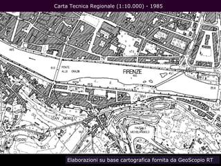
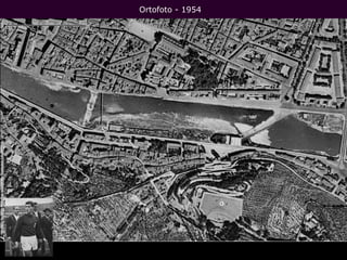
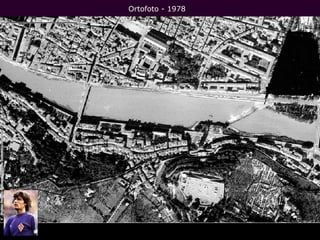
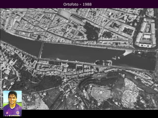
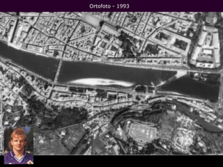
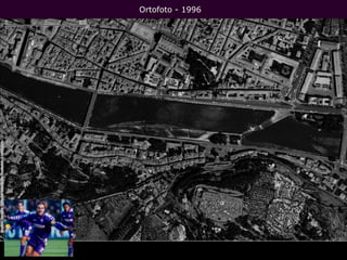
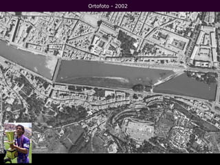
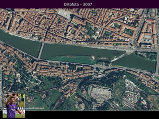
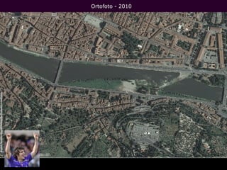
A simulation of extreme meteorological events in the Arno river basin.
Assuming the possibility that high intensity, short duration precipitation events could happen in the Arno river basin too, and referring to a registered extreme value for the maximum over 1 hour duration (100 mm), a list of more than two hundred small size basins were tested in order to estimate the maximum discharge peak.
From the comparison of this flash flood simulations with the 200-years return period discharges it's possible to understand where the hazard related to this extreme events is more relevant.
Using Radar Interferometric Satellite Data for Groundwater Management in the ...Bernardo Mazzanti
The Arno basin is rich in superficial and underground water resources, intensively exploited in the past for water supply services, and for agricultural and industrial uses as well.
Our Authority carried on in 2006 a detailed inventory of all water abstraction points in the basin, collecting more than 22.000 superficial withdrawals and more than 100.000 wells.
At this time we’re engaged in the maintenance of this database (checking, integrating, extending), with the aim to update our water balance plan, both for surface and groundwater. An updated, detailed water balance is one of the main measures foreseen in the River Basin Management Plan: in our opinion, an effective improvement of environmental conditions is feasible and sustainable only with such an objective and solid knowledge. And more than ever, in a changing climate.
In this framework, quantitative trends recognition for groundwater bodies is the big question. In situ monitoring, even with a high number of points (like in our region), reveals only a partial and temporal limited validity.
New monitoring techniques can give us a good answer to this need. In our contribution we’re going to show some application of interferometric data gathered from synthetic aperture radar. Since 2003 this type of data has been collected and elaborated from our office; first with the SLAM project with University of Florence Service for Landslide Monitoring, then exploiting the Extraordinary Monitoring Plan of Italian Environmental Ministry.
The goals of this application are:
- investigate of correlation between superficial terrain deformation (derived from interferometric data analysis) and groundwater exploitation and quantitative trends;
- define a quantitative evaluation of anthropic pressure and their impact over aquifers.
Building an INSPIRE compliant spatial data infrastructure supporting River Ba...Bernardo Mazzanti
The Water Framework Directive 2000/60/EC and the Flood Directive 2007/60/CE represent the pivotal reference legislation for the Arno River Basin Authority planning activities. In this respect, the Arno River Basin Authority has been entitled, under the transposed national law, to coordinate the activities of the Regions belonging to the Northern Apennines River Basin District and produce the River Basin Management Plan and the Flood Risk Management Plan.
Up and above the ambitious objectives set out in accordance with the two above mentioned Directives, (i.e. good status for all water bodies in the Member States by 2015; flood risk and landslide risk management), the complex administrative framework peculiar to the Italian State did not favour the implementation of the first River Basin Management Plans.
In this context, the Arno River Basin Authority interpreted its coordination role in a comprehensive way, also and above all, as regards to data management activities to support the production of the plans and their maps.
Therefore the Authority has chosen, since the very beginning, to create a spatial data infrastructure for the collection, processing and dissemination of the river basin management plan’s related information.
Data documentation and network services were set up, accordingly, for cooperation purposes, for stakeholder inclusion and for dissemination activities as well.
The enforcement of the principles of the INSPIRE Directive and the adoption of its technical regulations were at the base of the reference work methodology concerning the cooperation between the Arno River Basin Authority and the Regions belonging to the District. On the other hand, this approach highlighted the delays that exist, at national level, as regards to the implementation of the Directive that do not allow to fully seize the opportunities offered by the adoption of its principles.
Cambiamento climatico: l'impatto nel bacino del fiume ArnoBernardo Mazzanti
Si riassumono alcune risultanze delle analisi alla base della valutazione degli effetti del cambiamento climatico nell'ambito del Piano di Gestione delle Acque e del Piano di Gestione delle Alluvioni.
Ricostruzione dell'evento di piena del 27/28 novembre 2012 su Mugnone, Vingone, Ema, Pesa. Elaborazioni effettuate su base dati Centro Funzionale Regione Toscana.