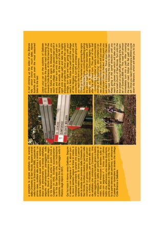
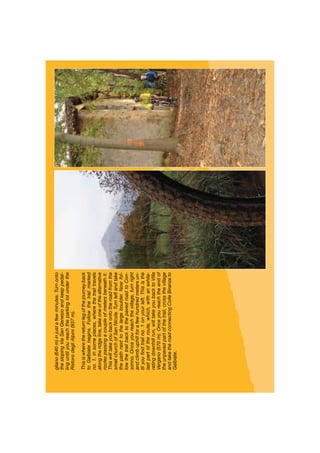
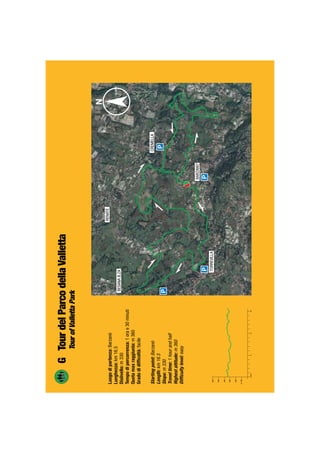
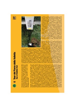
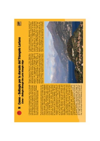
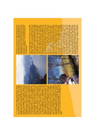
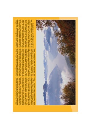
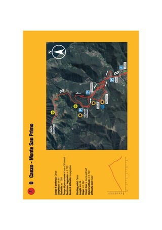
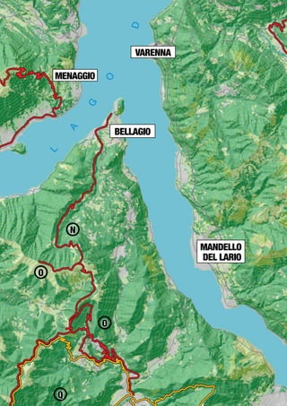
©ProvinciadiComoediLeccoAssessoratoalTurismoealloSport-Luglio2009.
IdeazionediAndreaMauriAGLAIAS.r.l.eventi&comunicazione,Lecco.
Grafica,impaginazioneetestidiAGLAIAS.r.l.www.aglaiasrl.it,Lecco.
Lefotografiesonodell’archivioAGLAIAS.r.l..
TuttiitracciatisonostatirilevatitramiteGPSprofessionaledaAndreaMauriconlacollaborazionediFrancescoMaspero.
Ortofotodigitaleacolori“ProgrammaIT2000”CompagniaGeneraleRipreseaereeS.p.a.-Parma-RegioneLombardiaconv.licenzad’usodel21.11.2000,inseritanellaraccoltaConvenzioni
eContratticonn.3289/RCCindata29.12.2000.
Tuttiidirittiriservati©ProvinciadiComoediLecco.Vietatalariproduzione,duplicazione,ancheparziale,conqualsiasimezzo,anchedigitale.
OgniabusosaràpunitosecondoiterminidiLegge.
Lafrequentazionedellamontagnarichiedeladovutapreparazioneedattrezzatura;siraccomandaquindidiadottaresemprelamassimaprudenza.Nelcasodiinfortuni,erroridipercorso,
condizioniparticolaridelterritoriononsiassumealcuntipodiresponsabilitàperchiconsultalapresenteguida.
Allrightsreserved©ProvinceofComoandLecco.Reproductionsandcopiesinwholeandinpartarestrictlyforbidden.AllabusesshallbepunishablebyLaw.
Visitingthemountainsrequiresbothappropriateequipmentandpreparation.Wethereforerecommendyouadoptmaximumcautionatalltimes.Noliabilityofanykindisassumedwithrespect
toguideusersincaseofaccidents,routemistakes,orspecificterritorialconditions.
InMountainBike/OnaMountainBike
GuidaaiPercorsi/Guidetotheroutes
Anchelamountainbike,comelealtredisciplinesportiveoutdoor,sisvolgein
ambientinaturalicherichiedonocuraerispetto:raccomandiamoagliutentidi
questaguidalamassimaattenzioneperl’ecosistemadeiterritoriattraversati.
Laguidasegnalaunnumeroampiodisentiericondifferentidifficoltà:ècomu-
nquenecessarioprevedereunminimodipreparazionefisicaperpoterliaffron-
tareintranquillità.D’altraparte,perquellipiùimpegnativiepiùlunghi,racco-
mandiamounaattentavalutazionedellapropriapreparazioneatleticaedelle
propriecapacità,tantoinsalitaquandoindiscesa.
Lecondizionidelterrenosonovariabiliinbaseallasituazioneclimatica,allapen-
denza,allaquotaeall’avvicendarsidellestagioni:suggeriamoquindidiprendere
inconsiderazioneanchequestifattoriperlamigliorriuscitadiogniescursione.
Ognipercorsovienetrattatonellasuacompletezzamaèinognicasopossibile
ridurreopportunamenteiltracciatosullabasedellepropriecapacità,seguendo
leindicazioniriportateinciascunaschedaattraversoleappositeiconeeidif-
ferenticolori.
Mountainbiking,likeanyotheroutdoorsport,isbestenjoyedinnaturalsur-
roundings.Thesemustbecaredforandrespected.Werecommendthatusers
ofboththisguideandthetrailsdescribedinitpaycloseattentionandcaretothe
ecosystemoftheterritoriestheyvisit.
Thisguidedescribesawiderangeofrouteswithvaryingdifficultylevels.A
certaindegreeofphysicalfitnessisneverthelessnecessarytosafelytravel
theseroutes.Werecommendyoucarefullyassessbothyourathletic
preparationandskills-bothuphillanddownhill-beforeattempting
someofthelongerandmoredifficulttrails.
Groundconditionsmayvaryaccordingtotheweather,slope,
altitudeandseason.Wethereforealsosuggestyoutakethese
factorsintoaccountinordertobestprepareforeachexcursion.
Thisguidedescribeseachrouteinitsentirety.Thesemayinanycasebeop-
portunelyshortenedbasedonyourownskillsandbyfollowingthesuggestions
containedineachtable,followingthedifferenticonsandcolours.
Location/Places
C’èunterritoriochevantaunanaturastupendaingradodiregalaresensazioniindimenticabili:èquellodelLagodiComoediLecco,ormainoto
intuttoilmondo.Questaguidaintendecondivideretalisensazioni,proponendoitineraricheseguonoletraccedellanaturaeconduconoinluoghi
incantevoliallascopertadellebellezze,deiritmi,deisegretidiunambienteincontaminato.Itineraridisegnatiinunpaesaggiodigrandefascinoche
sisnodanotrailverdeel’azzurroattraversovalli,boschi,radureerboseepratifioriti.Alcunidiquestisuggestivipercorsi,riprendendoviottoliemulat-
tieretracciatiasuotempodapastori,contadini,boscaioli,colleganonucleiruralicheparlanodiconsuetudinietradizioniremote;altriraggiungono
piccoliborghi,eremi,pievi,villepadronalichehannomantenutointattaneisecolilalorospecificitàarchitettonicaeoggicostituisconopiccoligioielli
distoriaecultura.
Ventunoitineraricicloturisticidapercorrereinsellaallamountainbike,corredatidacartinetopograficheconevidenziatiitracciatiedacomode
schede,unaperognisentierodescritto.Sonooltre600chilometrididistanzacomplessivaperundislivellodi19.000metri,unacombinazionedi
escursionismo,storiaecultura,disicurosuccessotraglisportivi.
Thisisaterritorywhichboastsofabreathtakingnaturalenvironmentcapableofimpartingunforgettableemotions:it’sComoLakefamousinallthe
World.Theaimofthisguideistosharetheseemotionswithyoubysuggestingitinerariesfollowingonnature’sfootsteps,leadingtomagicalplaces
andhelpingyoudiscoverthebeauty,rhythmandsecretsofanuntouched,naturalenvironment.Theitinerariesandtrailssnakethroughthegreen
andblueofafascinatingbackdropcomprisedofwoods,grassyclearingsandblossomingmeadows.Someofthesesuggestiveroutestravelalong
thesamepathsandmuletracksoncetravelledbyshepherds,farmersandwoodsmen,connectingsmallruralcommunitieswithantiqueandremote
traditions.Othersinsteadleadtotinyhamlets,monasteriesandvillaswhichhavepreservedtheircharacteristicarchitectureintactthroughoutthe
centuries,andhavetodaybecomesmallculturalandhistoricaljewels.Twelvecyclingitinerariestobeenjoyedonamountainbikecompletewith
topographicmapscontainingmarkedtrailsandhandytablesforeachoftheroutesdescribed.Withadistanceofmorethan600kilometresoverall
andaslopeof19.000metres,thiscombinationofhistory,cultureandtravelissuretobeahitamongsportsmen.
AssessorealTurismoealloSportAssessorealTurismo
ProvinciadiComoProvinciadiLecco
AchilleMojoliFabioDadati
InmountainbikeGuidaaiPercorsi/Onamountainbike,Guidetotheroutes
Localita’/Places
Presentazione/Presentation
Indice/Index
Legenda/Key
Notedell’autore/Author’snotes
Attrezzatura/Equipment
Appuntiditecnica/Technicalnotes
Brevedescrizioneitinerari/AbriefdescriptionoftheItineraries
A-Carenno-Pertus-Valcava
B-Ballabio-ForcelladiOlino-Artavaggio-Maggio-Ballabio
C-Crandola-PiandelleBetulle-ValBiandino-Introbio
D-TourdelmonteLegnoncino/TourofmountLegnoncino
E-CiclabiledellaValsassina/Valsassinacycleroute
F-TourdelSanGenesio/TourofSanGenesio
G-TourdelParcodellaValletta/TouroftheVallettaPark
H-LungoAdda-ParcoAddaNord/AlongtheAdda-NorthAddaPark
I-ParcodelCurone/CuronePark
L-Ballabio-PianideiResinelli-Traversatabassa/Lowcrossing
M-TourdellealturediLecco
N-Como-Bellagio-dorsaledelTriangoloLariano/LarioTriangleridge
O-Canzo-MonteSanPrimo
P-LagodelSegrino-Cornizzolo-LagodelSegrino
Q-Albavilla-Palanzone
R-TourdelParcoPineta
S-TourSpinaVerde
T-Cernobbio-MonteBisbino
U-Argegno-Tremezzo-Argegno
V-Corrido-PassoSanLucio-Corrido
Z-Garzeno-PassoSanJorio-Garzeno
CodicediComportamento/CodeofConduct
NumeriUtili/UsefulNumbers
03
04
05
06
07
08
09
10
12
16
20
24
28
32
34
38
42
46
50
54
58
62
66
70
74
78
82
86
90
94
98
100
INDICE
Legenda/Key
Percorsofacile
Easyitinerary
Percorsomedio
Mediumitinerary
Percorsoimpegnativo
Harditinerary
Direzionedelpercorso
Itinerarydirection
PuntodiPartenza
Startingpoint
Parcheggio
Parking
RifugioRistoro
HalpineHutRestaurant
Acquapotabile
DrinkableWater
Puntopanoramico
Panoramicpoint
Puntod’intersse
Interestingpoint
Funivia
Cableway
Legenda/Key
IlterritoriodellaProvinciadiComoediLeccohaincantatonel
corsodeisecoliconlasuabellezzapittori,comeLeonardoda
Vinci,scrittori,ComeStendhaloAlessandroManzoni,filosofie
scienziati,grazieaunambientenaturalefattodimontagnestraor-
dinariechesispecchianoinunlagoaffascinante.Oggirichiama
visitatoridatuttoilmondoattiratidaborghicomeBellagio,dalle
celebrivilleedailoroincomparabiligiardinifioriti,dallecollineche
offronovinoeolio...
Oggipossiamo,attraversoipercorsitracciatiinquestaguida,ritro-
varelostuporedifronteaunpaesaggioincomparabilepedalando
tranquillamenteattraversoboschi,colline,alzaie,attraversandodi
slancioifondovalle,inerpicandociconunpo’difaticasullecime,
percorrendoplacidamenteledorsalisuvallibellissimetutteda
scopriretralago,pianuraemonti,inunrincorrersidipaesaggi
semprenuovieinimitabili.
Perfarlobastapoco,perchéipercorsisonoaportatadiautoo
di…pedale.Treni,traghettiefunivieconsentonopoidicreare
tragittisumisuraeinediti.Levostregambefarannoilresto.
AndreaMauri
Overthecenturies,thebeautiesoftheProvincesofComoandLecco
havealwaysenchantedvisitors.Thesehaveincludedpainters,suchas
LeonardodaVinci,andauthors,suchasStendhalandAlessandroMan-
zoni,aswellasphilosophersandscientists,whohaveallbeenattractedto
itsextraordinarysceneryandmountains,reflectedinitsmesmerisinglake.
Today,visitorsfromaroundtheworldflocktotheareatovisittownssuch
asBellagio,withitscelebratedvillasandincomparableflowergardens,as
wellasitshillylandscapes,wherewinesandoilsareproduced…
Today,wecanrediscoverthisbreathtakingscenerybytravellingthe
routesdescribedinthisguide,gentlypedallingthroughwoods,hills,
andtowpaths,crossingvalleyfloorsinasinglebreath,strugglingupto
themountaintops,andplacidlytouringitsridgesalongbeautifulvalleys
surroundedbythelake,plainsandhillsinaprogressionofunforgettably
uniquelandscapesandsettings.
Youwon’tneedmuchtoenjoytheseroutes,it’seasy.Theyarejustacar
…orbicycleride…away.Trains,ferriesandcablewaysalsogiveyouthe
possibilityofcreatingyourown,uniqueroutes.Justletyourlegsdothe
rest.
AndreaMauri
Notedell’autore/Author’snotes
Attrezzaturaperriparareleforature,
camerad’ariadiscorta
eutensiliperpiccoliinconvenienti
Equipmenttorepairflattires,extratube,
andtoolstocountersmallsetbacks
Acquanellavostraborraccia,
integratorisalinieenergetici
Fillupyourwater/bottle,and
bringenergyandsalinesupple-
ments
Nonscordatevimai
diindossareilcasco
Alwayswearyourhelmet
Giaccaimpermeabileantivento
Waterproofandwindproofjacket
Luciposteriorieanteriori
Frontandbacklights
Attrezzaturaconsigliata
Equipement
Diseguitovengonofornitealcuneinformazioniutilisucomeaffrontareun’uscitainMTB.Nonsitrattadiobblighima,disuggerimenti,magariscontati
perchipraticaquestosportdamoltotempoma,chepossonoaiutareimenoespertiadeffettuare,intuttasicurezzaedivertendosi,ipercorsidescritti
inquestaguida.
Glielementiprincipalichedistinguonounbikerespertodaunneofitasonol’usoaccortodeifreni,lasceltadellatraiettoria,glispostamentidelcorpo
el’utilizzocorrettodelcambio.
IFRENIL’usocorrettodeifreninonèscontato;inparticolarmodoincasodidisceseconfortipendenzeèutilecombinarel’usodelfrenoanteriore
conquelloposteriore,senzabloccareleruotepernonperdereaderenza
econtrollo.Adottandonormalmentequestometododifrenatasieffet-
tuanolecosiddettecurveinconduzione,soloinalcunicasiparticolari
siricorrealbloccodellaruotaposteriorepereffettuarelecurveindera-
pata.Ilgiustodosaggiodellafrenatasuterrenicaratterizzatidacambidi
pendenzapermettedisuperareanchepiccolidossisenzafareusodeipedali,masfruttandolapropriavelocità.Normalmentelosforzomaggiore
dellafrenataèsupportatodalfrenoanterioredove,sullebicidafreerideequelledadownhillinmodoparticolare,sonomontatifreniadiscodidi-
mensionimaggioririspettoaquelliposteriori.
LATRAIETTORIALagiustasceltadellatraiettoriavariainfunzionedialcunifondamentalielementicomelacapacitàtecnica,lapreparazionefisica,le
condizionidelterreno(asciutto/bagnato)e,infine,iltipodimountainbikeutilizzata.Indiscesaperimenoespertièconsigliatoseguireunatraiettoria
sicuraescorrevole:ciòsignificaevitarediaffrontaresaltiedaltriostacoli,naturalienon,chepossonocausarecadute.Insalitalagiustatraiettoriaè
moltoimportanteinparticolarmodoquandosiaffrontaunfondosdrucciolevole,permantenereilmassimogripallegomme.
BILANCIAMENTODELCORPOGlispostamentidelcorpopermantenerel’equilibriosononumerosi,maall’occhiodelprofanopassanoquasi
inosservati.Affrontareunasalitaripidaconilpesospostatotroppodietrocausaloscaricodellaruotaanteriore,chetendeadalzarsiecausala
fermata;alcontrario,unaposizionetroppoavanzatascaricacompletamentelaruotaposteriore,cheperdegripelaruotagiraavuoto.Peraverela
posizionecorretta,quindi,èsufficienteportareilpesoversolapuntadellasella,ripartendoloinquestomodosiasullaruotaposterioresiasullaruota
anteriore;avendoorailbaricentrospostatoinavanti,sievitaallaruotaanterioredialzarsi.Diversoinveceèilproblemaindiscesa:infattiinquesto
casolospostamentoindietrodelpesoevitailribaltamento;inalcunicasièaddiritturanecessarioabbassarelasellaeportarelostomacosopradi
essa.Anchementresieffettuaunacurvalospostamentodelcorpopermettedirecuperareequilibrioedarestabilitàescorrevolezzaallamountain
bike.
USODELCAMBIOIlcorrettousodelcambioconsentedisfruttarealmeglioirapportidellabiciclettae,quindi,diavereunapedalata“rotonda”e
fluida,distribuendoleproprieforzelungotuttoilpercorso.Unusotroppoagiledelrapportofasicuramentepedalareveloci,maaffaticaipolmonie
ilmuscolocardiacoandando“fuorigiri”.Seinvecesiutilizzaunrapportotroppoduro,polmoniecuorelavoranonormalmente,masonolegambe
cheproduconounosforzoeccessivoe,inpocotempo,sono“fuoriuso”.E’quindinecessariotrovareunequilibriotralaforzaimpressadallegambe
eunbuonlavoroaerobico.
Appuntiditecnica
AlistofusefulinformationonhowtobestprepareforaMTBexcursionisfoundbelow.Noneofitismandatory;allarejustsuggestionswhichmight
evenperhapssoundabitoversimplifiedforthosewhohavebeenpracticingthissportforalongtime.Theycanhoweverhelpthelessexperienced
safelyenjoyadayoutontheroutesintheguide.
Thekeyelementswhichdistinguishexpertbikersfromnewbiesaretheirskilfuluseofthebrakes,theirchoiceoftrajectory,theirbodymovements,
andtheirpracticedgearshifts.
TheBRAKES.Usingyourbreakscorrectlyisnotthatsimple.It’simportanttocombinefrontandbackbrakeusewhenfacingsteepslopeswithout
lockingthewheelsinordertomaintainadherenceandcontrol.Youcanperform
acontrolledturnadoptingthisbrakingmethodorenterapowerslidebylocking
yourbackbrakeinstead,althoughthislasttechniqueshouldonlybeusedunder
specificcircumstances.Acorrectuseofthebrakesontheslopesallowsyouto
climbsmallbumpswithoutpedalling,justbyexploitingthespeedyouhavegath-
ered.Normally,thefrontbrakeisplacedunderthegreateststresswhenbraking.Thefrontwheelsonfreeridesanddownhillbikesinparticularare
fittedwithlargerdiscbrakescomparedtotheirbackwheels.
TheTRAJECTORY.Therightchoiceoftrajectoryvariesbasedonanumberofelementssuchasyourtechnicalskills,fitness,groundconditions(wet/
dry),andlastly,thetypeofmountainbikeyouride.Werecommendthatthelessproficientfollowasafe,smoothtrajectory.Thismeansavoidingjumps
andotherobstacles-bothnaturalandmanmade-whichcouldleadtofalls.Whenclimbinguphill,choosingtherighttrajectoryisveryimportant.This
isespeciallytruewhenfacingaslipperysurfacesoastomaintainmaximumtyregrip.
BODYBALANCE.Bikersemploymanydifferentbodymovementstokeeptheirbalance,mostofwhicharelittlenoticedbytheuninitiated.Ifyou
balanceyourbodyweighttoofarbackwhenfacingasteepclimb,thefrontwheeltendstorisefromthegroundandstopthebike.Ontheotherhand,
iftheriderleanstoofarforward,itisthebackwheelwhichcomesofftheground,loosinggripandspinningwithouttouchingtheground.Therefore,
toachieveacorrectposition,ridersmustmovetheirweighttowardsthefrontoftheseat,dividingituniformlybetweenthefrontandbackwheels.
Youcanavoidhavingyourfrontwheelliftedoffthegroundbymovingyourcentreofgravityslightlyforward.Bikersfaceadifferentproblemwhen
travellingdownhill.Infact,theonlywaytoavoidturningoveristomoveyourweighttowardstheback.Insomecasesriderswillevenhavetolower
theirseatsandthenlowertheirstomachsoverthemtoavoidflippingover.Bodymovementsallowbikerstomaintainequilibrium,stability,andflow
ontheirmountainbikeswhenenteringaturn.
GEARS.Acorrectuseofgearsallowsbikerstoobtaingreaterefficiencywiththeirbikes,andthereforeachieve“round”,smoothpedalling,dosing
theirstrengththroughouttheentirelengthoftheroute.Employingahighgearratiowillindubitablyhelpyoupedalfaster,butittiresthelungsand
heartmusclesforcingtheminto“overdrive”.If,insteadyourgearratioistoolow,theheartandlungsworknormallybutthelegsbecomeoverused
andarequickly“tiredout”.Thisiswhyfindingtherightbalancebetweenlegworkandaerobicexerciseissoimportant.
Technicalnotes
Brevedescrizioneitinerari
ItinerarioA:Carenno–Pertus-Valcava-ItinerariochepermettediraggiungerelacostieradellaValcava,riconoscibileinlontananzadallapresenzadinumerosipontiradio;dopounasalita
pedalabilesiaffrontaladiscesasustradabiancacheriportainpocotempoallapartenza.
ItinerarioB:Ballabio-ForcelladiOlino-Artavaggio-Maggio-Ballabio-Itinerarioparticolarmenteimpegnativodalpuntodivistafisicomasenzaparticolaridifficoltàtecniche.Ilpercorso,
datalasuaconformazione,puòessereinterrottoinvaripunti,cosìdaadattarsipuntualmenteaidifferentilivellidiallenamento.
ItinerarioC:Crandola-PiandelleBetulle-ValBiandino-Introbio-ItinerariomoltobellochepercorrelapartecentraledellaValsassina,attraversandopiùvallieoffrendopanoramiunici
edoriginalisututtoilterritorio.
ItinerarioD:TourdelMonteLegnoncino-L’itinerariopercorrelaValvarrone,unadellepiùaspreesuggestivevallichesiaffaccianosullaspondaorientaledelLario,dominatadalMonte
Legnone,lacimapiùelevatadellaprovinciadiLecco.Grazieallapresenzadirisorsemetallurgicheèstataabitatadall’uomofindaitempipiùantichi.
ItinerarioE:CiclabiledellaValsassina-E’unitinerariocheconsentedipedalareincompletatranquillità,idealepertuttalafamiglia,suunpercorsoappositamenterealizzatoesicuroche
permettediammirarelemontagnedellaValsassinaeconosceregliangolipiùbellienascostiafiancodelfiumePioverna.
ItinerarioF:TourdelSanGenesio-ItinerariocherisalelependicidellecollinedellaBrianzacheanticipanolebenpiùaltePrealpi,machemetteallaprovaancheilbikerpiùallenato.
ItinerarioG:TourdelParcodellaValletta-ItinerariocheattraversalezoneagricoledellaprovinciadiLeccoaridossodelconfineconlaprovinciadiMilano.Nonrichiedeparticolarepre-
parazionefisicaecapacitàtecniche,offrendocomunquesplendidiscorcisullemontagnelecchesi.
ItinerarioH:LungoAdda-ParcoAddaNord-Itinerariosenzapassaggitecnici,chenonrichiedeparticolarepreparazionefisica,risultacomunquemoltopiacevolepoichésisviluppalungo
l’arginedestrodell’Adda.Duranteilpercorsosipossonoosservarevariespeciediuccelliacquatici,magnificiscorcisulResegoneesulleGrignedaunlatoe,dall’altro,sulleverdicollinebrian-
zole.
ItinerarioI:ParcodelCurone-Percorsoadanello,conunaseriedisaliscendi,estremamenteinteressantedalpuntodivistadell’ambienteperchéattraversacampievitigni,fattorie,cascine
efornacicherestituisconogliantichimestieriesaporidellaBrianzacontadina.
ItinerarioL:Ballabio-PianiResinelli-Traversatabassa-Itinerariomoltobelloedisoddisfazione,cheattraversailgruppodelleGrignesupercorsidimediamontagna,conunavarietàdi
paesaggitipicidelluogo;èpercorribiledallatardaprimaverafinoalleprimenevicateinvernali.
ItinerarioM:TourdellealturediLecco-PercorsiconpartenzaeritornoaLecco,sullemontagnecircostanti,perscoprireineditiscorcisullagoesullevette,adattidapercorrereallasera,
dopoillavoro,ocomeallenamento,facilmentemodulabiliinlunghezza.
ItinerarioN:Como-BellagioperladorsaledelTriangoloLariano-L’itinerariosisviluppalungotuttaladorsalechedivideidueramidelLario,attraversaboschidifaggieprati,regalando
vistemozzafiatosulleprovincediLeccoeComo,terminandoconunadivertentediscesafinoaBellagio,metaturisticadilivellointernazionale.
ItinerarioO:Canzo-MonteSanPrimo-AssolutamentecomparabileperbellezzaadaltrelocalitàpiùfamosedelLario,ilpercorsoraggiungelacimadelMonteSanPrimo,ilpiùaltodel
TriangoloLarianoepermettedidominaretuttoilLarioeleGrigneversoEst.E’digrandesoddisfazioneciclistica.
ItinerarioP:LagodelSegrino-Cornizzolo-LagodelSegrino-PercorsopanoramicosullaBrianzaeilTriangoloLarianocheassicuraunadiscesalungaedisoddisfazione,ingradodi
ripagaredell’impegnorichiestodallasalita.
ItinerarioQ:Albavilla-Palanzone-LasalitaalMontePallanzonecompletalaconoscenzadelterritoriodelTriangoloLariano,abbianataaipercorsiM,NePdellaguida,aSudalcospetto
dellaBrianzaedeisuoilaghi.
ItinerarioR:TourdelParcoPineta-Percorsosemplice,susterratodiottimaqualità,adattoallafamiglia,conlapossibilitàdiosservaredavicinonumerosiallevamentidicavalliedimodificare
lalunghezzadeltracciatosecondoleproprieesigenze.
ItinerarioS:TourSpinaVerde-FacileitinerarioalleportediComochepermettesiadiallenarsiperpercorsipiùimpegnativi,checonoscereilParcoe“scoprire”lalineaCadorna.
ItinerarioT:Cernobbio-MonteBisbino-Bell’itineraiosulconfineItaloSvizzerochesisviluppainquotaepermettediconoscerevallie“vallette”benpedalabilialcospettodellago.
ItinerarioU:Argegno-Tremezzo-Argegno-NonpuòmancareunapedalataalmonteTremezzoalciclistachevuoleconoscereilLagodiComo.Dascegliereunabellagiornataegodersi
l’incredibileeunicopanoramasullagoesullemontagne.Ladiscesapropostaèsicuramentealternativaalleclassiche,pocofuoristradistichechesipossonocompiere.Nonadattaatuttiein
particolareachisoffredivertigini.Mamaipericolosooinopportuno.
ItinerarioV:Corrido-PassoSanLucio-Corrido-Percorsocheportaalconfineitalo-svizzeroepermettediconoscerelaValdiRezzoelaValCavargna,passandodalfondovalleaglialpeggi
diquotaconunavistaspettacolaresuAlpiePrealpiOrobiche.
ItinerarioZ:Garzeno-PassoSanJorio-Garzeno-Tragittoimpegnativoperlalunghezzaelosviluppochenellaprimaparte,suasfaltoesterrato,offreun’incomparabilevisionedelLagodi
ComoedelMonteLegnone,perpoipercorrerelaValleSanJoriofinoalpassoomonimo,sulconfineitalo-svizzero,inunambientemontanodirarabellezza.
Abriefdescriptionoftheitineraries
TrailA:Carenno–Pertus–Valcava–ThistrailtakesriderstothecoastofValcava,easilyrecognisableinthedistancebecauseofitsmanyradiolinks.Afteranuphillcycle,awhiteroadwill
takebikersdownhillandbacktotheirstartingpointinjustafewminutes.
TrailB:Ballabio–ForcelladiOlino–Artavaggio–Maggio–Ballabio–Averytiringtrailfromaphysicalpointofview,butnotparticularlydifficultintermsofskills.Becauseofthewayitis
designed,severalstopscanbemadealongtherouteinordertobestsuitdifferentfitnesslevels.
TrailC:Crandola–PiandelleBetulle–ValBiandino–Introbio–AbeautifultrailaccompanyingbikersthroughthecentralpartoftheValsassina,itcrossesanumberofvalleys,andoffers
riderspeerlessviewsoftheterritory.
TrailD:TourofMountLegnoncino–ThetrailtravelsthroughValvarrone–oneofthemostruggedlysuggestivevalleysofthearea,overlookingthewesternbankoftheLarioanddominated
bytheMonteLegnone,thehighestpeakintheprovinceofLecco.Thisvalleyhasbeeninhabitedbymansincethedawnoftimebecauseofitsrichmineralresources.
TrailE:ValsassinaCycleroute-Thistrailisidealfortheentirefamily.Ablissfulcycleonasafe,speciallydesignedroute,itallowstravellerstoadmirethemountainsofValssassinaanddiscover
someofthemostbeautifulandwell-hiddencornersofthePiovernaRiver.
TrailF:TourofSanGenesio–AtrailclimbingupthesidesoftheBrianzahills-whichmirrorthe,muchtaller,Alpinefoothillsandputseventhemostseasonedbikertothetest.
TrailG:TouroftheVallettaPark-AtrailacrosstheruralcountrysideoftheprovinceofLeccoontheborderwiththeprovinceofMilan.Thisroutedoesnotrequireparticularphysicalfitness
orskills,butallthesameoffersridersbreathtakingviewsfromtheLeccomountainsides.
TrailH:AlongtheAdda–NorthAddaPark–Atraildevoidoftechnicalpassagesandwhichdoesnotrequireparticularphysicalfitness.Itisnonethelesshighlyenjoyable,asitaccompanies
bikersdowntherightbankoftheAdda.Variousdifferentspeciesofwaterbirds,beautifulviewsoftheResegoneandGrigneononesideandthegreenBrianzahillsontheothercanbeallbe
admiredallalongtheroute.
TrailI:CuronePark–Acircularroutewithaseriesofuphillanddownhillclimbs,thistrailisparticularlyinterestingfromanenvironmentalpointofviewsinceitcrossesfieldsandvines,farms,
homesteadsandbrickyards-reflectingtheancienttastesandworksofthefarmingcommunitiesinhabitingtheBrianzacountryside.
TrailL:Ballabio-PianiResinelli-Lowcrossing-AbeautifulandhighlyenjoyabletrailcrossingtheGrigneonmediummountaintrailsframedbytheeverchangingscenerytypicalofthe
area.Thisroutecanbetravelledfromlatespringupuntilthefirstwintersnows.
TrailM:TourhillsidearoundLecco-ThisstrikingitinerarystartsandendsinLecco.Ittakesbikersonatourofitsnearbymountainstosavourarrestingviewsofthelakeandpeaks.The
itineraryissuitableandcanbeenjoyedintheevening,afterwork,orastraining,sinceitcanbeeasilyadjustedintermsoflength.
TrailN:Como–BellagiothroughtheLarioTriangleridge–ThistrailrunsalongtheridgedividingthetwobranchesoftheLario,cuttingthroughbeech-woodforestsandfields,giftingtravel-
lerswithbreathtakingviewsoftheprovincesofLeccoandComo.ItendswithanenjoyabledownhillridedowntoBellagio,aworldrenownedtouristdestination.
TrailO:Canzo–MonteSanPrimo–Incomparableintermsofbeautytoother,morefamous,locationsintheLario,theroutetakestravellerstothetopoftheMonteSanPrimo,thehighest
mountainintheLarioTriangle,whichdominatesalloftheLarioandGrignetowardstheeast.Thisisahighlyenjoyablerideforbikers.
TrailP:LakeSegrino–Cornizzolo–LakeSegrino-ApanoramicitineraryofBrianzaandtheLarianoTrianglewithalong,satisfyingdownhillsectionprovidingfullpaybackforalloftheeffort
madeduringtheuphillclimb.
TrailQ:Albavilla-Palanzone-WhencombinedwithroutesM,NandPintheguide,theclimbtoMontePalanzonecompletesourexplorationoftheLarianoTriangletothesouth,rightnext
toBrianzaanditslakes.
TrailR:TourParcoPineta-Thiseasyitineraryunfurlsalongadirtroadofexcellentquality.Itcanbeenjoyedbythewholefamilyandgiveseveryonethechancetocatchaglimpseofanumber
ofhorsebreedingfarms.Thelengthoftheitinerarycanalsobechangedtosuitindividualneeds.
TrailS:TourSpinaVerde-AneasyitineraryrightoutsidethegatesofComo,perfectbothastrainingformorechallengingroutesandasameansvisittheParkand“explore”theCadornaline.
TrailT:Cernobbio-MonteBisbino-Astrikingitinerary,highupontheItalian-Swissborderthatallowscycliststoexplorethevalleysnearthelakeontheirbikes.
TrailU:Argegno-Tremezzo-Argegno-NonpuòmancareunapedalataalmonteTremezzoalciclistachevuoleconoscereilLagodiComo.Dascegliereunabellagiornataegodersi
l’incredibileeunicopanoramasullagoesullemontagne.Ladiscesapropostaèsicuramentealternativaalleclassiche,pocofuoristradistichechesipossonocompiere.Nonadattaatuttiein
particolareachisoffredivertigini.Mamaipericolosooinopportuno
TrailV:Corrido-PassoSanLucio-Corrido-ThisitinerarywilltakeyoutotheItalian-SwissborderandwillgiveyouachancetoexplorebothValdiRezzoandValCavargna.Itpassesthrough
thebottomofthevalleystoreachAlpinesummerpasturesathighaltitudes,withspectacularviewsoftheAlpsandBergamoAlps.
TrailZ:Garzeno-PassoSanJorio-Garzeno-Thisitineraryisdescribedaschallengingbothbecauseofitslengthandbecauseofthefeaturesspecifictoitsfirstleg.Ittakesplacealong
bothapavedroadandadirtroad,andoffersbikersanunsurpassedviewofLakeComoandMonteLegnonebeforetravellingthroughValleSanJoriototheeponymouspassontheItalian-Swiss
border,surroundedbyabreathtakingmountainlandscape.
Luogodipartenza:Carenno
Lunghezza:km17
Dislivello:m745
Tempodipercorrenza:2ore
Quotamaxraggiunta:m1.358
Gradodidifficoltà:medio
Startingpoint:Carenno
Length:Km17
Slope:m745
Traveltime:2hours
Highestaltitude:m1.358
Difficultylevel:medium
ACarenno-Pertus-Valcava
COLLEDISOGNO
FORCELLAALTA
ACarenno-Pertus-Valcava
Itinerariochepermettediraggiungerelaco-
stieradellaValcava,riconoscibileinlonta-
nanzadallapresenzadinumerosipontiradio;
dopounasalitapedalabilesiaffrontaladisce-
sasustradabiancacheriportainpocotempo
allapartenza.
PuntodipartenzaèilcamposportivodiCa-
renno(m650),dovesiimboccalastrada
asfaltatacheportaallafrazionediBoccio(m
850).Oltrepassatelecase,lastradadiviene
sterrataedèbloccataaltransitomotorizzato
daunasbarra.Lasalitaprosegueinmezzoad
unboscodicastagni.Pocodopoaveroltre-
passatoleultimecasediBoccio,siincontra
unadeviazionesulladestrachevaignorata
perproseguirediritto.Raggiuntalacascina
diMonteBesso(m1.055),siprosegueverso
l’alto,superandounaripidarampacementata
alterminedellaqualelasalitaconcede,per
pochimetri,unpo’direspiro.Quest’ultimo
trattoècaratterizzatodastrappicortimari-
pidi,chemettonoallaprovalaresistenzadel
biker.GiuntiqualchemetrosottoilConvento
delPertus(m1.183),siignoraladeviazione
perilPassoomonimo,perpercorreregliul-
timiduetornantichepermettonodivedere,
sullasinistra,l’ex-Convento.Ilpercorsopro-
seguesullastradaprincipale,passandosotto
ilRistorodelPertusino(m1.183)eraggiun-
gendo,dopoqualchecentinaiodimetri,la
viachesaleinValcava.Aquestopuntosolo
pochitornanticiseparanodalGPM(Gran
PremiodellaMontagna)diquestoitinerario.
GiuntiallaForcellaAlta(m1.358),valicoche
dividelaprovinciadiLeccodaquelladiBer-
gamo,unospiazzoinvitaallasostaperpre-
pararsialladiscesaeammirareilpanorama
sullePrealpi.Rimontatiinsellaallanostradue
ruoteiniziamosoddisfattiladiscesache,ini-
zialmente,ricalcailpercorsodisalita,perpoi
imboccareilsentierocheportaversol’abita-
todiCollediSogno,incorrispondenzadel
tornantesuccessivoalpuntodiimmissione
dellastradaperlaValcava.Questotrattodi
sentiero,nonpedalabilenellasuatotalità,in
pochiminutipermettediraggiungerel’abitato
diCollediSogno(m950).Dopoaverattraver-
satoicaratteristicivicoli,prenderelastrada
asfaltatacheindiscesaportaversoilcomune
diSogno.Primadiraggiungereilpaese,subi-
todopounacurvaversosinistra,imboccare
sulladestralastradacementataindiscesa
perIncasone(m831).Quisialternanotratti
conpendenzepiùripideadaltrimenoim-
pegnativi.Dopoaverpercorsocirca1km,si
raggiungeuncolleoltreilqualesiaprelaValle
diCarenno,doveilpercorsosidivide.Seguire
lastradadidestrache,dopoqualchecambio
dipendenza,ciportanelfondovalle,a200m
didistanzadalparcheggiodipartenza.
Thistrailtakestravellersuptothecoastof
Valcava,easilyrecognisableinthedistance
becauseofitsmanyradiolinks.Afteranuphill
cycle,awhiteroadwilltakeyoubackdownhill
toyourstartingpointinjustafewminutes.
ItbeginsattheCarennosportscentre(650
m),wherethepavedroadwilltakeyoudown
toBoccio(850).Oncepastthehouses,the
roadbecomesunpavedandbarredtomo-
tortraffic.Theuphillclimbcontinuesinsidea
chestnutwood.Afterridingpastthelastfew
housesofBoccio,youwillseearighthand
turn.Ignoreit,andkeepgoingstraight.Keep
climbingpasttheMonteBessofarmhouse
(1,050m).Onceyoupassthesteepcement
ramp,youwillbeabletotakeabreatherfor
afewminutes.Thislastpartoftherouteis
markedbyshort,butverysteepclimbs,which
willtestyourresistanceasabiker.Oncebe-
lowtheConventofPertus(1,183m),ignore
theturnforthePasswiththesamename,and
keepgoingaroundthelasttwoturns,which
willgiveyouaviewoftheformerConventon
yourleft.Thetrailcontinuesalongthemain
road,passingundertheRistorodelPertuisino
(1,183m)andreaching–afterafewhundred
metres–theroadclimbinguptoValcava.
Atthispointyouareonlyafewturnsaway
fromthistrail’sMGP(MountainGrandPrix).
OnreachingtheForcellaAlta(1,358)–the
passdividingtheprovinceofLeccofromthe
provinceofBergamo-youwillfindaclearing
whereyoucanrest,admiretheviewoftheAl-
pinefoothills,andprepareyourselffortheride
down.Backinthesaddleofyourbike,anen-
joyabledownhillrideinitiallydoublingbackon
therouteyoutravelledcominguphillbefore
turningontothepath,willtakeyoutoColledi
Sogno-nearthebendoftheroadfollowing
thebeginningoftheroadtoValcava.
Thispartofthetrail,whichcannotbetrav-
elledinitsentiretybybike,willtakeyouto
CollediSogno(950m)injustafewmin-
utes.Aftercrossingitscharacteristicalleys,
takethepavedroaddownhillinthedirection
ofSogno.Turnrightontothepavedroadto
Icasone(831m),whichyouwillfindonyour
rightaftertheleft-handturnbeforethevillage.
Thispartofthetrailismarkedbyaseriesof
steeperandgentlerslopes.Aftertravellingfor
approximately1kmyouwillfindyourselfon
thehillinfrontoftheopeningfortheValledi
Carenno,wherethetrailforks.Taketheright
handpath,whichafteraseriesofupsand
downs,willtakeyoutothefloorofthevalley,
just200mawayfromtheparkinglotofyour
startingpoint.
Luogodipartenza:Ballabio
Lunghezza:km54
Dislivello:m1.317
Tempodipercorrenza:4oree30minuti
Quotamaxraggiunta:m1.875
Gradodidifficoltà:impegnativo
Startingpoint:Ballabio
Length:Km54
Slope:m1.317
Traveltime:2hoursandhalf
Highestaltitude:m1.875
Difficultylevel:hard
BBallabio-ForcelladiOlino-Artavaggio-Maggio-Ballabio
Itinerarioparticolarmenteimpegnativodal
puntodivistafisicomasenzaparticolaridiffi-
coltàtecniche.Ilpercorso,datalasuaconfor-
mazione,puòessereinterrottoinvaripunti,
cosìdaadattarsipuntualmenteaidifferenti
livellidiallenamento.
L’itinerarioinizianelparcheggiodelcimiterodi
Ballabio(m640).Imboccarelastradachecon
unaserieditornantisaleversoilcomunedi
Morterone:inquestoprimotrattoèasfaltata
erisaleiversantidelMonteDueMani.Sullato
oppostodellaValBoazzosipossonoammira-
regliimpervipendiidelResegone.Raggiunta
laForcelladiOlino(m1.117),oltrepassarela
galleriaeprenderelastradasterratasullasi-
nistra(chiusadaunasbarra)che,conalcuni
saliscendi,permettediraggiungerelaCulmi-
nediSanPietro(m1.254).Siscendequindi
per1kmcircasustradaasfaltataindirezione
Valsassina;dopo1,5kmcirca,sulladestra,
iniziaunastradasterratachiusaaltrafficovei-
colarenonautorizzato.Questotrattodiper-
corsorisaleleboscosependicidelloZucdi
Maesimoe,percorrendo9kmcirca,portaai
PianidiArtavaggio(m1.610).Quièpossibi-
leinterromperelasalitaperfermarsialrifugio
SassiCastelli,oppureproseguireperunaltro
paiodichilometrifinoadarrivareaiRifugiAu-
rora,Nicola,Cazzaniga-Merlini(m1.875).
Ripercorrereindiscesalastradaappenabat-
tutae,unavoltaraggiuntalastradaasfaltata,
risalirefinoallaCulminediSanPietro.
Quisvoltareadestraeripercorrerelaster-
rataprovenientedallaForcelladiOlino,per
prendere,dopouncentinaiodimetri,lavec-
chiastradasulladestra.Raggiuntoilpaese
diMaggio,lastradatornaadessereasfalta-
ta.Proseguireindiscesafinoaraggiungereil
CollediBalisiodovesisvoltaasinistraper-
correndolaSP62dellaValsassina,indirezio-
nediBallabio,puntodipartenza.
Percorsialternativi
Questopercorsoèsoggettoanumerose
varianti,tralepiùsignificativeindichiamo
lapossibilitàperlefamigliediraggiungere
laCulminediSanPietroconl’auto,perpoi
imboccarelastradaagro-silvo-pastoraleche
portainlocalitàCàMüsc’ada.
Arathertiringtrailfromaphysicalpointof
view,butnotparticularlydifficultintermsof
skills.Becauseofthewayitisdesigned,sev-
eralstopscanbemadealongtherouteinor-
dertobestsuitdifferentfitnesslevels.
ThetrailstartsintheBallabiocemetery(640
m)parkinglot.Taketheroadwhichwilltake
youtoMorteroneviaaseriesofhairpinbends.
Thisfirstpartoftheroadispavedandwilllead
youupthesideoftheMonteDueMani.On
thesideoppositetoValBoazzoyouwillbe
abletoadmiretheruggedslopesoftheRe-
segone.OnreachingForcelladiOlino(1,117
m),ridepastthegalleryandtaketheunpaved
roadontheleft(barred)which,afterafewups
anddowns,willleadyoutotheCulminediSan
Pietro(1,254m).Ridedownhillforapproxi-
mately1kmonthepavedroadinthedirec-
tionofValsassina.Afterapproximately1.5km,
youwillfindanunpavedroadwhichblocked
offtotraffic.Thispartofthetrailclimbsupthe
woodedslopesoftheZucdiMaesimo.After
travellingapproximately9km,youwillarrive
atthePianidiArtavaggio(1,610m).Youcan,
atthispoint,takeabreakfromyourclimband
stopattheSassiCastellirefuge,orelsekeep
goingforacouplemorekilometresandreach
theAurora,Nicola,Cazzaniga-MerliniAlpine
refuges(1,875m).
Ridebackdownhillonthesamepath,and,
onceyoureachthepavedroad,climbupto
theCulminediSanPietro.Turnrightonthe
unpavedroadfromForcelladiOlinoand-af-
teraboutahundredmeters-taketheoldroad
ontheright.Theroadwilloncemorebecome
pavedwhenyoureachthevillageofMaggio.
Continuetravellingdownhilluntilyoureach
CollediBasilio.TurnleftandtaketheValsas-
sinaSS62(stateroad)towardsyourstarting
pointofBallabio.
Alternativeroutes
Thistrailhasnumerousvariations.Oneofthe
mostpopularamongfamiliesistotraveltothe
CulminediSanPietrobycar,andthentake
theruralroadtoCàMüsc’ada.
Luogodipartenza:Crandola
Lunghezza:km31
Dislivello:m1.268
Tempodipercorrenza:4oree30minuti
Quotamaxraggiunta:m1.970
Gradodidifficoltà:impegnativo
Startingpoint:Crandola
Length:km31
Slope:m1.268
Traveltime:4hoursandhalf
ighestaltitude:m1.970
Difficultylevel:hard
CCrandola-PiandelleBetulle-ValBiandino-Introbio
Itinerariomoltobellochepercorrelaparte
centraledellaValsassina,attraversandopiù
vallieoffrendopanoramiuniciedoriginalisu
tuttoilterritorio.
Lanostrapropostaperpercorrerequesto
itinerariopartedaCrandola(m780)dovesi
iniziasubitoinsalitaimboccandolaviaai
Maggenghi.Lastradaèinizialmenteasfaltata
epoisterratafinoalPiandelleBetulle,con
lependenzechesifannosemprepiùimpe-
gnative.Alprimobiviosiproseguesulper-
corsoasinistra,ignorandoladeviazioneper
l’AlpeBesso;successivamentesiignorauna
secondadeviazionesullasinistracheporta
allastallaPiazza.L’impegnativasalitaconti-
nuaeattraversal’AlpeGrasso(m1.341)per
giungereinfinealPiandelleBetulle(m1.485).
Peribikersmenoallenatièpossibileridurre
questoprimotrattodisalitausufruendodella
funiviachedalpaesediMargnoconduceal
PiandelleBetulle,oppuresalendoinautofino
all’AlpePaglio(m1.368)eprendendolastra-
dacarrozzabilecheportainpochiminutial
PiandelleBetulle.Orasiabbandonanoipiani
percorrendoperunbrevetrattolepistedasci
aridossodelleultimecase,prendendosulla
destrailsentieroinleggerasalitachesiinol-
tranelbosco.Siattraversal’abitatodell’Al-
peOrtighera(m1.512),siaggiralavettadel
CimonediMargnoesiraggiunge,semprein
salita,lalocalitàLariceBruciato(m1.708).Si
segnalaun’areapic-nicelapresenzadiuna
fonted’acquapochimetriprima.
Iltracciato,semprebelloedemozionante,ora
scendediquotaperqualchedecinadimetri;
unavoltaraggiuntalaBocchettad’Olino(m
1.639)ricominciaasalire,semprebenpeda-
labile,finoaraggiungereunapresadell’acqua
checoincideconlafinedellastrada.Ilsentie-
rochesegue,datalasuaripidità,costringea
spingerelabicifinoaraggiungerelaBocchet-
tadiAgoredo(m1.825).Daqui,ènecessario
seguireleindicazioniperSantaRita,sempre
insalitaper200mcirca,perpoiscenderefino
allalocalitàLaghitt.
Iltrattochesegueèabbastanzatecnicoedè
necessariomoderarelavelocitàpoichéilsen-
tierocorreincrestaeipendiisottostantisono
alquantoripidi.Superatoiltralicciodell’alta
tensione,sigiungeadunbiviodovesisegue
ilcartelloCAIsulladestra,indirezionelocalità
Biandino.Silasciaquindiilsentierodicresta
perprenderequelloche,indiagonale,attra-
versaipendiifinoadarrivarenelfondovalle.
Ilpercorsoèespostomadall’inclinazionenon
troppoaccentuata,conalcunipassaggidove
consigliamodiprestareattenzione.Giuntisul-
lastradacarrozzabiledifondovalle,sisalein
pochiminutialRifugioMadonnadellaNeve,
metafinalediquestopercorso.
LadiscesapercorretuttalaValBiandinosu
fondospessocementato,atrattiripido(fare
attenzionealpossibiletransitodimezzifuo-
ristrada),finoaraggiungerel’abitatodiIntro-
bio.DaIntrobiosipercorresuasfaltolaSP62
dellaValsassina,indirezionenord,pertorna-
realpuntodipartenza:Crandola.
Percorsialternativi
L’alternativapropostaèsolodownhill.Sali-
reinfuniviadaMargnoalPiandelleBetulle:
scesidallafuniviatenereladestraindirezione
Margno,percorrendounprimotrattoince-
mentocongratedidrenaggioepoisucarroz-
zabileperentusiasmantidiscesefinoaCran-
dola,quindisustradaordinariaalparcheggio
diMargno,puntodipartenzadelpercorso.
Abeautifultrailaccompanyingbikersthrough
thecentralpartoftheValsassina,itcrossesa
numberofvalleys,andoffersriderspeerless
viewsoftheterritory.
OursuggestionforthistrailstartsatCrandola
(780m)withanabruptuphillclimbontheroad
leadingtoMaggenghi.Althoughtheroadis
initiallypaved,itsoonbecomesunpavedall
thewaytoPiandelleBetulle.Itisalsomarked
byseriesofincreasinglydifficultuphillclimbs.
Turnleftatthefirstforkoftheroad,ignor-
ingtheturntowardstheAlpeBessoandig-
noringthefollowingturnonthelefttowards
thePiazzastables.Continueclimbinguphill,
crossingtheAlpeGrasso(1,341m)untilPian
delleBetulle(1,485m).Lessfitbikerscanre-
ducethislastpartoftheclimbbyeithertak-
ingthecablewayfromMargnotoPiandelle
Betulle,orbytravellingbycaruptotheAlpe
Paglio(1,368m)andthentakingthecarriage
roadtothePiandelleBetulle–whichisjust
afewminutesaway.Thetrailnowabandons
levelgroundtofollowtheskirunsbehindthe
lastfewhouses.Itthenturnsrightontothe
slightlyuphillpathenteringthewoods.Pass-
ingbythehousesofAlpeOrtighera(1,512m)
thepathturnsaroundthesummitofCimone
diMargoand,stillclimbinguphill,takesyou
toLariceBruciato(1,708m).Youwillfinda
picnicareahere.
Thisspectacularlybeautifultrailwillnowtake
youdownhillforacouplehundredmetres,
beforeclimbingupagainattheBocchetta
d’Olino(1,639m).
Thispathiseasilytravelledandwillleadyou
toawaterspoutattheendoftheroad.At
thispoint,givenitssteepness,thetrailforces
youtopushyourbikeuptotheBocchettadi
Agoredo(1,825m).Followthedirectionsto
SantaRitafromhere,andcontinueclimb-
ingforabout200mbeforeridingdownhillto
Laghitt.
Thisnextpartofthetrailisquitetechnical.
Makesureyouslowdownasyoutravelalong
ridgebecausetheslopesbeneathitarequite
steep.Youwillfindaforkintheroadafter
passingapylon.Taketheroadontheleft
markedbytheCAIroadsigninthedirectionof
Biandino.Thetrailnowleavestheridgeand,
cuttingdiagonallydowntheslopes,takesyou
tothefloorofthevalley.
Therouteisexposed,butnottoosteep.How-
ever,werecommendyoutakecare,especially
duringsomeofthemoredifficultparts.Once
youreachtheroadonthevalleyfloorthetrail
willtakeyouuptotheMadonnadellaNeveAl-
pinerefuge,whichistheendpointofthejour-
ney.Thedownhillpartofthetrailrunsthrough
theentireBiandinoValley.Oftenpavedand
sometimesrathersteep(keepaneyeoutfor
off-roadvehicletraffic),thispathwilltakeyou
toIntrobio.TakethenorthboundValsassina
SP62(provincialroad)fromIntrobiotoreturn
toCrandola.
Alternativeroutes
Theonlyalternativeofferedinthiscaseisto
traveldownhill.TakethecablewayfromMar-
gnotoPiandelleBetulle.Turnrighttowards
Margnofromthecableway,andtraveldown
thepavedroadwiththegrateddrainageditch.
Keepgoingallthewaydownforanexhilarat-
ingdownhillridetoCrandola.Atthispoint
taketheordinaryroadbacktoyourstarting
pointattheMargnoparkinglot.
Luogodipartenza:Dervio
Lunghezza:km39,50
Dislivello:m1.720
Tempodipercorrenza:5orecirca
Quotamaxraggiunta:m1761
Gradodidifficoltà:impegnativo
Startingpoint:Dervio
Length:km39.50
Slope:m1.720
Traveltime:approximately5hours
Highestaltitude:m1761
Difficultylevel:hard
DTourdelmonteLegnoncino
TourofmountLegnoncino
DTourdelmonteLegnoncino
TourofmountLegnoncino
L’itinerariopercorrelaValvarrone,unadelle
piùaspreesuggestivevallichesiaffacciano
sullaspondaorientaledelLario,dominatadal
MonteLegnone(m2.610),lacimapiùeleva-
tadellaprovinciadiLecco.Grazieallapre-
senzadirisorsemetallurgicheèstataabitata
dall’uomofindaitempipiùantichi.
Puntodipartenzaèlastradaasfaltatacheda
DerviosaleinValvarrone(SP67)dovesiin-
contra,perprima,lafrazionederviesediCa-
stello,unbelnucleodicasedominatedalla
torredelCastellodiOrezia(delqualesihanno
notizieapartiredal1039,annoincuisubìun
lunghissimoassedio).Siattraversapoiilpae-
sediVestreno(m587)dovesiimbocca,sulla
sinistra,lastradaperSueglio(m775)edalì
siprocedeperilRifugioBellano.Attraversa-
toSueglio,continuaresustradaasfaltatafino
all’incontrodell’indicazioneperilRistorodel
Capriolo(possibilitàdiparcheggio),dopo
averpercorsodiversitornanti.Prenderequin-
dilastradasterrataedinleggerasalitasulla
destra,percirca2km.Siaffrontanooragli
ultimichilometridiasfaltomoltoimpegnativo,
superandogliabitatidiLavadèe(m1.306)e
diBocchetta(m1.362),raggiungendolalo-
calitàRoccoliLorla(m1.451)(possibilitàdi
parcheggioepuntodiristoro).Sullasinistra,
inunboscodilarici,inizial’ultimosterrato
dellanostrasalitache,anchesetecnicamen-
tefacile,presentaalcunitrattidifortepen-
denza.Lavecchiastradamilitareportafino
allaChiesettadiSanSfirio(m1.700),dovesi
“abbandona”labiciclettaperraggiungerea
piedilavettadelLegnoncino(m1.714).Da
quisigodeunavistapanoramicaveramente
unica,chespaziasull’orizzontedalLarioalla
ValtellinaeallaValChiavenna,sututtol’arco
alpinofinoalMonteRosaealMonviso.Ripre-
salabicisiripercorrelastessastradaveloce
edivertentefinoallalocalitàdeiRoccoliLor-
la,sicosteggianoilprato(conareapic-nic)
edillaghettoperprendereilsentiero(sono
presentiindicazioni)checonducealRifugio
Bellano(apertosuprenotazione)eaiRoccoli
diArtesso.Questotrattoèriccodipuntipa-
noramicisull’altoLarioeattraversalestoriche
postazionimilitariappartenentialla“Linea
Cadorna”,inottimostatodiconservazione.
Iltracciatorichiedeladovutaattenzionedata
lapresenzadinumerosiostacolinaturali.Su-
peratiiRoccolidiArtessosiriprendelastrada
asfaltatacheriportaversoDervio.Raggiunto
VestrenosiimboccaviaAlbacinocheporta,
in1kmcirca,all’invaso.Oltrequestopuntola
stradatornaadesseresterratafinoagiunge-
readunbiviodovesisegueiltracciatoche
continuainsalita.OltrepassatalaChiesadel-
laMadonnadiBondo,siprendeladeviazione
sulladestrachepermettedievitarel’attraver-
samentodelcentroabitatodiSparese.Una
discesavelocesufondocementatoportafino
allalocalitàdiPosallo,dovelastradatorna
adessereasfaltata.Daqui,inpochiminuti,
siraggiungeilcentrodelpaesediColico,
terminedelnostropercorso.Perchiudereil
percorsoadanelloripercorrerelaSP72indi-
rezioneMilanofinoaDervio.
Percorsialternativi
Lanostrapropostaèquelladipercorrere
l’anellodelMonteLegnoncinoevitandogran
partedeldislivelloinsalita:parcheggiare
l’autoall’imboccodellasterratacheportaal
RistorodelCapriolo,perpoiritornarvidopo
averseguitoleindicazionisopradescritte.
ThistrailrunsthroughValvarrone–oneofthe
mostruggedlysuggestivevalleysofthearea,
overlookingthewesternbankoftheLarioand
dominatedbytheMonteLegnone,thehigh-
estpeakintheprovinceofLecco.Thisvalley
hasbeeninhabitedbymansincethedawnof
timebecauseofitsrichmineralresources.
Yourstartingpointisthepavedroadwhich
takesyouuptoValvarrone(SP67)fromDer-
vio,firsttravellingthroughthehamletofCas-
tello-aprettysettlementdominatedbythe
toweroftheCastleofOrezia(whoseoldest
recordsdatebackto1039,whenitsuffered
throughalengthysiege).Thetrailthenruns
acrossthevillageofVestreno(587m),turn-
ingleftontheroadtoSueglio(775m)and
thencontinuingontotheBellanoAlpineref-
uge.Keeptravellingonthepavedroadafter
youpassSuegliountilyoureachthesignfor
theRistorodelCapriolo(parkingspacesavail-
able),whichfollowsanumberofhairpinturns
ontheroad.Fromheretaketheslightlyup-
hill,unpaved,roadonyourrightforabout2
km.Thelastfewkilometresofthispavedroad
areratherdifficult,andwilltakeyoupastthe
hamletsofLavadèe(1,306m)andBocchet-
ta(1,362m)beforearrivingatRoccoliLorla
(1,451m)(parkingspacesavailable).Thelast
unpavedpartofouruphillclimbbeginshere
amongstthelarches.Althoughtechnically
easy,thispartoftheroutecontainsanum-
berofverysteepslopes.Theoldmilitaryroad
willtakeyoutothesmallchurchofSanSifirio
(1,700m),whereyouwillhaveto“abandon”
yourbicycleinordertoreachthesummitof
Legnoncino(1,714m)onfoot.Atrulyunique
vistaopensupfromhere,stretchingfromthe
LariototheValtellinaandontotheValChia-
vennaonthehorizon,encompassingtheen-
tirealpinearcallthewaytotheMonteRosa
andMonviso.Backonyoubike,takethesame
quick,enjoyableroadrunningparalleltothe
field(completewithpicnicarea)andlakeback
toRoccoliLorla.Atthispoint,takethetrail(it
willbesignposted)leadingtotheBellanoAl-
pinerefuge(openedonreservation)andRoc-
colidiArtesso.Thislegoftherouteisfilled
withpanoramicpointsonthehighLarioand
travelsthroughaseriesofperfectlypreserved
militarypostsofhistoricimportanceonthe
“CardonaLine”.Thetrailisfullofnaturalob-
stacles,sotakecareatthispoint.Oncepast
RoccolidiArtesso,takethepavedroadback
toDervio.OnreachingVestreno,taketheAl
Bacinoroadwhichwilltakeyoutothereser-
voirafterapproximately1km.Atthispointthe
roadwillonceagainbecomeunpaveduntil
itdividesitselfintotwo.Attheforkcontinue
totraveluphill.Oncepastthechurchofthe
MadonnadiBondo,taketheforkontheleft
whichwillallowyoutoavoidridingthrough
thevillageofSparese.Aquickridedownhill
onacement-pavedroadbedwilltakeyouto
Posallowheretheroadonceagainbecomes
paved.Fromherewillbeabletoreachthevil-
lageofColico–theendofourjourney–in
justafewminutes.Toclosethelooprideback
downtheSP72inthedirectionofMilanuntil
youreachDervio.
Alternativeroutes
OursuggestionistotaketheMonteLegnon-
cinoloopavoidingmostoftheuphillclimb.
Parkyourcarthebeginningofthepavedroad
takingyoutotheRistorodelCapriolo,and
thentravelbacktowardsthecaralongthe
trailsdescribedabove.
Luogodipartenza:ChiusadellaValsassina
Lunghezza:A/Rkm13
Dislivello:m92
Tempodipercorrenza:30minuti
Quotamaxraggiunta:m570
Gradodidifficoltà:facile
Startingpoint:ChiusadellaValsassina
Length:km13
Slope:m92
Traveltime:halfanhour
Highestaltitude:m570
Difficultylevel:easy
ECiclabiledellaValsassina
Valsassinacycleroute
Thistrailisidealfortheentirefamily.Ablissful
cycleonasafe,speciallydesignedroute,it
allowstravellerstoadmirethemountainsof
Valssassinaanddiscoversomeofthemost
beautifulandwell-hiddencornersofthePio-
vernaRiver.
Itbeginsattheso-called“Chiusa”oftheVal-
sassina(570m),theareaborderingtherocky
sidesontheoutskirtsofthevalley,before
reachingthevillageofIntrobioneartothe
bridgeonthePiovernariver.Alargesignwill
pointyoutowardsthecyclerouteontheleft
handsideoftheriver.Theroutesnakesdown
thebankofthePiovernaandwilltakeyouto
thevillageofPratoSanPietro/Cortenova(478
m).Theentirecyclerouteispavedandeasy
totravelon.Itisparticularlysuitedtofami-
lies,andidealfororganisingpicnics,swimsin
theriverduringthehottermonthsoftheyear,
visitstotheneighbouringvillagesandother
sportingactivitiessuchashorsebackridingat
oneofthemanyridingschoolsdottedalong
thetrail.
ECiclabiledellaValsassina
Valsassinacycleroute
Èunitinerariocheconsentedipedalarein
completatranquillità,idealepertuttalafami-
glia,suunpercorsoappositamenterealizzato
esicurochepermettediammirarelemonta-
gnedellaValsassinaeconosceregliangolipiù
bellienascostiafiancodelfiumePioverna.
Lapartenzaèpressolacosiddetta“Chiusa”
dellaValsassina(m570),lalocalitàincorri-
spondenzadiparetirocciosechedelimitano
lavalle,pocoprimadiarrivarealpaesediIn-
trobio,incorrispondenzadelpontesulfiume
Pioverna.Unevidentecartelloindicalapista
ciclabilesullatoorograficosinistrodelfiume.
IlpercorsosisnodaafiancodeltorrentePio-
vernaegiungefinoalpaesediPratoSanPie-
tro/Cortenova(m478).Laciclabileècomple-
tamentesuasfaltoenonpresentadifficoltà;
particolarmenteadattaperinucleifamigliari,
permettediorganizzarepic-nic,bagninelfiu-
menellastagionepiùcalda,visiteaipaesie
altreattivitàsportive,comel’equitazione,in
unodeimaneggichesiincontranosultrac-
ciato.
Luogodipartenza:Galbiate
Lunghezza:km31
Dislivello:m1.044
Tempodipercorrenza:2oree30minuti
Quotamaxraggiunta:m937
Gradodidifficoltà:medio
Startingpoint:Galbiate
Length:km31
Slope:m1.044
Traveltime:2hoursandanhalf
Highestaltitude:m937
Difficultylevel:medium
FTourdelSanGenesio
TourofSanGenesio
FTourdelSanGenesio
TourofSanGenesio
Itinerariocherisalelependicidellecolline
dellaBrianzacheanticipanolebenpiùalte
Prealpi,machemetteallaprovaancheilbiker
piùallenato.
Lasciatal’autopressoGalbiate(m370)sise-
guelastradaasfaltatachesaleversoColle
Brianza:allaprimacurvaprendereleindica-
zioniperMozzanafinoaraggiungerequesta
località.Percorrerelastradaasfaltatasinoal
suotermineeimboccareilsentieroche,in
salita,siaddentranelbosco.Giuntisulpunto
discollinare,svoltareadestraesuperareun
trattoripido;inseguitopercorrereunsingle-
trekdivertente.Appenaoltrepassatounpon-
ticelloincementosvoltareadestrafinoaun
prato.Siseguequindiilsentierosinoalpae-
sediVillaVergano:proseguireindiscesaper
incrociarelaSP58,svoltareasinistrafinoa
incontrareladeviazioneperConsonno
Salireversoquest’ultimalocalitàe,dopoaver
ignoratoleindicazioniperlaCascinaFigina,
proseguireancorasuasfaltopercirca1km.
Subitodopounacurvaversodestrainiziail
sentierocheportaalMonteCrocione.Que-
stopassaggiodistrada,inizialmentedalle
pendenzefacili,versoilsuoterminepre-
sentatrattiacciottolatichemettonoadura
provaancheipiùallenati.Siraggiungecosì
unincrociodoveènecessarioseguirelacar-
rarecciaprincipale,conindicazioniperSan
Genesio.Proseguireinquestadirezionefino
AtrailclimbingupthesidesoftheBrianza
hills-whichmirrorthe,muchtaller,Alpine
foothillsandputseventhemostseasoned
bikertothetest.
LeaveyourcarontheoutskirtsofGalbiate
(370)andfollowthepavedroadclimbingup
towardsColleBrianza.Atthefirstbendofthe
road,followthesignstoMozzanauntilyou
reachthevillage.Takethepavedroaduntilit
ends,andthenturnontotheuphillpathen-
teringthewoods.Attheendofthehill,turn
rightontoasteeppathandtakethehighly
enjoyablesingle-trek.Oncepastthecement
bridge,turnrightandkeepgoinguntilyour
reachafield.Followthepathuntilthevillage
ofVillaVergano.Continuedownhilluntilyou
crosstheSP58,turnleft,andkeepgoinguntil
youreachtheforktoConsonno.
Climbuptothehamletand,ignoringthesigns
totheCascinaFigina,continuetravellingalong
thepavedroadforanotherkilometre.Apath
takingyoutoMonteCrocionebeginsright
aftertheleft-handturn.Thispartofthetrail
-containinganumberofeasilysurmountable
inclinesatthebeginning-alsocontainsase-
riesofpebbledtractswhichwillputeventhe
mostexpertbikertothetest.Atthispointyou
willreachacrossroads.Traveldownthemain
cartroad,followingthesignstoSanGenesio.
Keepgoinginthesamedirectionuntilyou
reachthepavedroadwhichwilltakeyouto
thesmallchurchofSanNicola.Turnontothe
firststreetonyourleftafterenteringtheham-
letofScerizza(698m).Thisroadwillalmost
immediatelyturnintoapath.Aftercrossing
thepavedroad,followtheflatpathonthe
left.OnceyoureachGiovenzana(650m)cycle
downViaManzoni,whichwilltakeyoutoCa-
aprenderelastradaasfaltatachescende
dallaChiesettadiSanNicola.Appenaentrati
nellafrazionediScerizza(m698),superatele
primecase,svoltareallaprimaasinistra.La
stradasitrasformaquasisubitoinsentiero:
dopoaverattraversatounastradaasfaltata,
seguirlonell’andamentopianeggiantesulla
sinistra.GiuntiaGiovenzana(m650)segui-
reViaManzonicheportainpochiminutia
Cagliano(m640).Svoltaresuccessivamen-
teinViaSanGenesioche,coninclinazione
costante,conducefinoalparcheggiosottoil
RistorodegliAlpini(m937).
QuihainizioilritornoversoGalbiate.Seguire
ilsentieroconsegnavian°1.Inalcunipun-
ti,doveilsentieroseguelalineadicresta,è
necessarioprenderelevariantichepassano
qualchemetrosotto.Sitornacosìapercor-
rerelastradacheprovienedallaChiesettadi
SanNicola.Svoltareadestrasusentieronelle
vicinanzediungrossomasso.Orasipercor-
re,aritroso,iltracciato,perarrivareallastra-
daasfaltatacheconduceaConsonno.Una
voltaraggiuntaquestalocalità,girareadestra
eproseguireinsalitaperpochecentinaiadi
metri,finoadimboccareilsentierosullasi-
nistraconsegnavian°1.Iniziacosìl’ultimo
trattoche,attraversounadiscesadivertente,
portaall’abitatodiVillaVergano(m570).Fini-
talapartesterratadelpercorso,siattraversa
ilpaeseperriprenderelastradachecollega
ColleBrianzaaGalbiate.
gliano(640m)injustafewminutes.Turnonto
theslopingViaSanGenesioandkeeppedal-
linguntilyoureachtheparkinglotunderthe
RistorodegliAlpini(937m).
Thisiswherethereturnlegofthejourneyback
toGalbiatebegins.Followthetrailmarked
no.1.Insomeplaces,wherethetrailtravels
alongtheridgeline,takeoneofthealternative
routespassingacoupleofmetersbeneathit.
Thiswilltakeyoubackontotheroadfromthe
smallchurchofSanNicola.Turnleftandtake
thepathnexttothelargeboulder.Nowfol-
lowthetrailbacktothepavedroadtoCon-
sonno.Onceyoureachthevillage,turnright
andclimbuphillforafewhundredmetersun-
tilyoufindtrailno.1onyourleft.Thisisthe
lastpartoftheroute,which,withanexhila-
ratingdownhillrun,willtakeyoubacktoVilla
Vergano(570m).Onceyoureachtheendof
theunpavedpartofthetrail,crossthevillage
andtaketheroadconnectingColleBiranzato
Galbiate.
Luogodipartenza:Barzanò
Lunghezza:km16.5
Dislivello:m330
Tempodipercorrenza:1orae30minuti
Quotamaxraggiunta:m360
Gradodidifficoltà:facile
Startingpoint:Barzanò
Length:km16.5
Slope:m330
Traveltime:1hourandhalf
Highestaltitude:m360
Difficultylevel:easy
GTourdelParcodellaValletta
TourofVallettaPark
GTourdelParcodellaValletta
TourofVallettaPark
Itinerariocheattraversalezoneagricoledella
provinciadiLeccoaridossodelconfinecon
laprovinciadiMilano.Nonrichiedepartico-
larepreparazionefisicaecapacitàtecniche,
offrendocomunquesplendidiscorcisulle
montagnelecchesi.
Questoitinerarioiniziadalparcheggionei
pressidelcentrogiovanile“PaoloVI”aBar-
zanò.Siinforcalabiciclettaindirezione
Dagò.Dopopochecentinaiadimetri,incor-
rispondenzadiunacurva,silascialastrada
principaleperimboccare,sullasinistra,una
stradinaasfaltatacheprestositrasformain
sentiero.Attraversatol’abitatodiTorrevilla
(m350),siproseguedirittofinoadunbivio,
doveprendiamolastradaindiscesasullade-
stra;dopounatrentinametrisisvoltaasini-
stra.Questotrattoindiscesa,chevaversoil
camposportivo,oltrepassaCascinaMagritto
mantenendolasinistraepervieneaduntrat-
toasfaltatoinsalitacheportainViaRossini.
Svoltareadestraepercorrerelastradafino
allarotonda:altrasvoltaadestrae,dopoal-
cunimetri,ancoraunasvoltaadestra.Orala
stradadiventaunsentieroinleggeradisce-
sacheraggiungeilRoccolo(m332),passa
afiancodellaCascinaRampina,attraversa
ViaBocconieraggiungeCascinaCanova(m
343).Unavoltaaggiratoilcascinale,ilsentiero
attraversaicampieportafinoallalocalitàBe-
sanelle.Neipressidiungrossonocesvoltare
diontani,finitoilqualesisvoltaprimaasini-
straepoisubitodopoadestrapercorrendola
sterratacheportafinoallaCascinaBonacina
(m313).Lastrada,asfaltataedinsalita,con-
duceadunincrociodovesiproseguediritto
attraversandoivicolidiOriano.Seguireper
lalocalitàZizzanorree,attraversounsentie-
ro,raggiungerelalocalitàTorricella.All’uscita
delsentieroprendereilvicolosullasinistra
e,giuntiallarotonda,svoltarenuovamentea
sinistraindirezioneCremella,finoadincro-
ciarelaSP48.Passandovicinoalcampo
sportivo,attraversarelaprovincialeesvoltare
asinistraallaprimadeviazione.Albiviosuc-
cessivogirarenuovamenteasinistra,attra-
versareunponticelloe,dopopochedecinedi
adestraepercorrerelastra-
dabiancafinoalsuotermine,
perpoiproseguiredrittobat-
tendolastradaasfaltatanella
suatotalità.Svoltarequindi
adestraindiscesaeimboc-
carelaprimastrada,sempre
sulladestra(ViaTagliamento
chedopopochimetridivie-
nesterrata).Giuntialprimo
bivioprenderelastradaster-
ratasullasinistra,percorrer-
laperqualchecentinaiodi
metrifinoadarrivareaduna
sbarrasullapropriadestra
cheimpediscel’accessoal
campoaimezziamotore.Svoltareadestra
eseguirelatracciafinoaraggiungerelaCa-
scinaCalegari(m320)equindiViaBocconi.
Attraversatalastrada,proseguiredrittofino
araggiungerelalocalitàMottione(m325),
dovesisvoltaasinistra.Dopoaversuperato
larotondaneipressidellaMadonnina,svol-
tareadestrainunsentierocheraggiungela
localitàVillanova(m346).Girareasinistrain
direzioneDagòe,neipressidiunacurvade-
strorsa,prendereilsentierosullasinistrache
portaaPrebone(m321);proseguiredritto,
senzapassaresottoilportico,imboccando
ilsentierocheportaadunapianainmezzo
aicampi.Giuntiadunbiviotenerelasinistra,
finoadattraversareuncaratteristicobosco
metri,imboccareilsentierosulladestrache
salealRoccoloLietti(m370).Seguireprima
latracciaindiscesasulladestra,poiquella
sullasinistracheportaneipressidellaCasci-
naPeltraio(m370).GiuntiaVerdegòsvolta-
reasinistrae,dopopochimetri,dinuovoa
sinistraperViaPertini.Dopounbrevetratto
didiscesaimboccareilsentierosullasinistra
chesiaddentranelbosco.Alcunisaliscendi
ciconduconoalsentiero,sulladestra,indi-
rezioneMortidell’Avello.GiuntiallaChiesetta
dellaMadonnadelCarmine(m380),aggirarla
perprendereilsentierocherisaleeraggiun-
gelaCascinadiMontegregorio.Sorpassata
quest’ultima,svoltareadestraepoidinuovo
destradopoqualchecentinaiodimetriindi-
rezioneCremella.Unavoltatornatisustrada
asfaltasvoltareasinistra.Lastradasalealle
spallediVillaSessae,lasciandolaasinistra,
iniziaascendereperivicoli,finoariprendere
laSP48.Svoltarequindiadestraeimbocca-
relastradadisinistra,subitodopolescuole.
Questaviadiventasubitosterrata;oltrepas-
satountrattoindiscesa,girareasinistraperil
sentierocheportaaTorrevilla.Giuntidinuovo
albiviodiTorrevilla,prenderelastradasulla
destracheconduceadunaltrobivio,dovesi
mantienelasinistra.Imboccarelaprimastra-
dasulladestracheinpochiminutiriportaal
parcheggiodipartenza.
Atrailtravellingthroughtheruralareasof
theProvinceofLeccoontheborderwiththe
provinceofMilan.Thisroutedoesnotrequire
particularphysicalfitnessorskills,butallthe
sameoffersridersbreathtakingviewsfrom
theLeccomountainsides.
Thistrailstartsoffintheparkinglotnextto
the“PaoloVI”youthcentreinBarzanò.Mount
yourbicycleinthedirectionofDagò.Aftera
fewhundredmetres,nearacurve,turnleft
offthemainroadontoapavedroad–which
willquicklyturnintoapath.Passingtheham-
letofTorrevilla(350m),keepgoinguntilyou
reachaforkintheroadandturnrightontoa
downhill-slopingroad,thenturnleftafterap-
proximatelythirtymetres.Thisdownhillpart
oftheroute,whichwilltakeyoutowardsthe
sportsfield,passesbytheCascinaMagritto.
Keepingleftyouwillreachapavedroadwhich
willtakeyoutoViaRossini.Turnrightandfol-
lowtheroaduntiltheroundabout.Turnright
again,andafterafewmetres,turnrightagain.
Theroadwillnowbecomeafaintlydownhill
pathwhichwilltakeyoutoRoccolo(332m)
passingbytheCascinaRampina,through
ViaBocconiandtoCascinaCanova(343m).
Onceyouhavecircledthefarmhouse,the
pathwilltakeyouthroughanumberoffields
downtoBesanelle.Turnrightnearthelarge
walnuttreeandfollowthewhiteroaduntilit
ends,thencarryondownthepavedroadun-
tilitalsoends.Turnrightdownhillandtake
thefirstroadonyourright(ViaTagliamento,
whichbecomesunpavedafterafewmetres).
Atthefirstforkoftheroad,turnontotheun-
pavedroadonyourleft.Followthisroadfor
afewhundredmetresuntilyoureachabar-
rieronyourrightblockingmotorvehicleac-
cesstothefield.Turnrightandfollowthetrail
untilCascinaCalegari(320m)andthenVia
Bocconi.Crosstheroadandcarryonstraight
downuntilyoureachMottione(325m),where
therouteturnsleft.Turnrightaftertheround-
aboutnearMadonninaandontoapathwhich
willtakeyoutoVillanova(346m).Turnleftin
thedirectionofDagòtakingthepathonyour
leftleadingtoPreboneneartherighttwist-
ingcurve.Keepgoingstraight,passunderthe
portico,andtakethepathheadingtowards
thefields.Turnleftwherethepathforksand
keepgoinguntilyoucrossanAlder-wood
copse,whereyouwillfirstturnleftandthen
immediatelyturnrightfollowingtheunpaved
roaduntiltheCascinaBonacina(313m).The
road–pavedanduphill–willtakeyoutoa
crossroads.Keeptravellingstraightthrough
thealleysofOriano,onthepathtowardsZiz-
zanorreuntilyoureachTorricella.Attheend
ofthepath,takethealleyonyourleft,and,
onceyou’vereachedtheroundabout,turnleft
againtowardsCremella.Keepgoinguntilyou
reachtheSP48.Asyoupassnearthesports
field,crosstheprovincialroadandturnonto
thefirstroadonyourleft.Turnleftagainatthe
nextcrossingandtakethepathonyourright
climbinguptoRoccoloLietti(370m)which
youwillfindafewmetresafterthebridge.
Followthefirsttraildownhillonyourright,and
thentheoneonyourleft,whichwilltakeyou
closetotheCascinaPeltraio(370m).Once
you’vereachedVerdegò,turnleft,andthen
turnleftagainafewmetresfurtherontowards
ViaPertini.Afterashortdownhillride,takethe
pathenteringthewoodsonyourleft.Afew
upsanddownswilltakeyoutotherighthand-
sidetrailleadingtoMortidell’Avello.Cycle
aroundthechurchoftheMadonnadelCar-
mine(380m)andtaketheuphillpathtowards
theCascinadiMontegregorio.Turnleftonce
you’vereachedthis;thenturnleftagainafter
afewhundredmetresinthedirectionofCre-
mella.Turnleftagainonceyou’vehitthepaved
road.TheroadclimbsupbehindVillaSassa,
andleavingitbehindontheleft,startssloping
backdownthroughthealleysuntilitturnright
andtaketheroadonthelefthandside,right
aftertheschools.ThiswillreachestheSP48.
almostimmediatelybecomeunpaved.Aftera
shortdownhillride,turnleftontothepathto
Torrevilla.Onceyou’vereachedtheTorrevilla
crossing,turnrightontotheroadwhichwill
takeyoutoanothercrossingandkeepleft.
Takethefirstroadonyourright,andinjusta
fewminutesyouwillbebackattheparkinglot
youstartedofffrom.
Luogodipartenza:Olginate
Lunghezza:A/Rkm30
Dislivello:m120
Tempodipercorrenza:1oree30minuti
Quotamaxraggiunta:m235
Gradodidifficoltà:facile
Startingpoint:Olginate
Length:km30roundtrip
Slope:m120
Traveltime:1hourand30minutes
Highestaltitude:m235
Difficultylevel:easy
HLungoAdda-ParcoAddaNord
AlongtheAdda-NorthAddaPark
HLungoAdda-ParcoAddaNord
AlongtheAdda-NorthAddaPark
Itinerariosenzapassaggitecnici,chenonri-
chiedeparticolarepreparazionefisica,risulta
comunquemoltopiacevolepoichésisvilup-
palungol’arginedestrodell’Adda.Duranteil
percorsosipossonoosservarevariespeciedi
uccelliacquatici,magnificiscorcisulResego-
neesulleGrignedaunlatoe,dall’altro,sulle
verdicollinebrianzole.
PuntodipartenzaèilcamposportivodiOlgi-
nate.Scenderelastradaprincipalefinoall’ar-
ginedelfiumeeproseguiresinoaraggiun-
gereilpontedellaferrovia,doveunasbarra
vietal’accesso.Daquestopuntolastrada
diventasterrataepercorribilesolodabici-
cletteepedoni.Èsubitopossibileammirare
labellezzadelleGrigneedelResegoneche
sispecchianonelleacquedell’Adda.Dopo
avercosteggiatoalcunicampidigranoturco
arriviamoalpaesediBrivio(m196),nelcui
centrostoricosiergeuncastelloche,insie-
meaquellidiLecco,TrezzoeCassano,co-
stituivapartedelsistemadifensivodell’Adda.
Passaresottoilpontechecollegalasponda
leccheseconquellabergamascaeprose-
guire,peralcunecentinaiadimetrisustrada
asfaltata;successivamentelastradatornaad
esseresterrataechiusaaltraffico.Immersi
nelverdesiprosegueapedalareseguendole
ansedelfiume,frequentatedamoltespecie
divolatiliacquatici.Dopoqualchechilometro
raggiungiamoImbersago,doveèpossibile
Atraildevoidoftechnicalpassagesandwhich
doesnotrequireparticularphysicalfitness.
Itisnonethelesshighlyenjoyable,asitac-
companiesbikersdowntherightbankofthe
Adda.Variousdifferentspeciesofwaterbirds,
beautifulviewsoftheResegoneandGrigne
ononesideandthegreenBiranzahillsonthe
othercanbeallbeadmiredalongtheroute.
TheOlginatesportsfieldisthestartingpoint
ofthetrail.Ridedownthemainroaduntilyou
reachthebankoftheriver,andkeepgoing
straightuntilyoucometotheblocked-offrail-
waybridge.Atthispointtheroadbecomes
unpavedandcanonlybetravelledbyfootor
bike.Here,youwillbeabletocatchaglimpse
ofthebeautyoftheGrigneandResegonere-
flectedinthewatersoftheAdda.Afterskirt-
ingafewfields,youwillreachtheVillageof
Brivio(196m).Itshistoricalcentreisdomi-
natedbyacastlewhich,togetherwiththose
inLecco,TrezzoeCassono,madeuppartof
thedefencesoftheAdda.Passingunderthe
bridgeconnectingtheLeccosideoftheriver
withtheBergamoside,keepgoingdownthe
pavedroadforafurtherfewhundredmeters.
Atthispointtheroadwillonceagainbecome
unpavedandclosedtotraffic.Immersedinthe
greencountryside,thetrailwilltakeyoudown
thebankoftheriver,whichinhabitedbymany
differentspeciesofaquaticbirds.Afterafew
kilometresyouwillreachIbersago,whereyou
willbeabletocatchaferrytocrosstheriver.
Travellingsouthwardsdownthetowpath;you
willsoonreachalargegorgehousingtheRob-
biatedam(198m).ThisiswheretheLeonardo
Ecomuseum–atrailconsistingof14different
stopsofcultural-historicalsignificance-be-
gins.Soonafterwardsyouwillreachtheim-
prendereuntraghettoricostruitosecondoil
progettocheideòLeonardoDaVinci,perat-
traversareilfiume.Proseguendolungol’alzaia
indirezionesudtroviamolagrandeforradove
sorgeladigadiRobbiate(m198).Inquesta
zonainizial’ecomuseodiLeonardo,percorso
compostoda14tappediinteressestorico-
culturale.Pocodopotroviamoilmaestoso
ponteinferrodiPadernod’Adda,realizzato
nel1899,checonlasuacampataunicacolle-
galeprovincediLeccoeBergamo.Ilponteè
utilizzatosuduepianidiversirispettivamente
dallaferroviaedallacircolazioneveicolare;
dall’altodeisuoi80metrisigodediunavista
mozzafiatosulcanyonsottostante.Lastrada,
oraasfaltata,correlungol’alzaiafinoarag-
giungereladigadiPoiret(m186),dovesiim-
boccailsentierodidestrachesalesufondo
acciottolato.Dopopochimetri,nelmezzodi
unacurvaversodestra,prendereilsentiero
sullasinistrache,conalcunisaliscendi,fian-
cheggiaunpiccolocanaleepermettedirag-
giungereStallazzo(m177),centroinformativo
dell’ecomuseo.Arrivatinelpuntopostopiùa
suddelnostropercorso,cambiamodirezione
pertornareversoladigadiPoiret.Giuntialla
diganonrestachepercorrerearitrosoilresto
delpercorso.
posingironbridgeofPadernod’Adda.Built
in1899,itconnectstheprovincesofLecco
andBergamo.Thebridgeisusedontwodif-
ferentlevelsbyboththerailandroadtraffic.
Here,youcanenjoyabreathtakingviewofthe
canyonunderneaththebridgefromitsheight
of80metres.Thetrail,whichonceagainbe-
comespaved,continuesalongtotowpath
untilitreachesthePoiretdam(m186)and
turnsrightontoapebbleduphillpath.Aftera
fewmeters,andhalfwaythrougharight-hand
turn,takethepathonyourleftwhich,aftera
fewupsanddowns,skirtsasmallcanalun-
tilitreachesStallazo(177)-theEcomuseum
informationcentre.Thisisthesouthernmost
pointofourroute.Herewechangedirection
andcomebackuptowardsthePoiretdam.
Onceyou’vereachedthedam,takethesame
pathyou’vetravelledonthewaydowntore-
turntoyourstartingpoint.
Luogodipartenza:Montevecchia
Lunghezza:km25
Dislivello:m500
Tempodipercorrenza:2oree30minuti
Quotamaxraggiunta:m615
Gradodidifficoltà:medio
Startingpoint:Montevecchia
Length:km25
Slope:m500
Traveltime:2hoursand30minutes
Highestaltitude:m615
Difficultylevel:medium
IParcodelCurone
CuronePark
IParcodelCurone
CuronePark
Percorsoadanello,conunaseriedisaliscen-
di,estremamenteinteressantedalpuntodi
vistadell’ambienteperchéattraversacampie
vitigni,fattorie,cascineefornacicherestitui-
sconogliantichimestieriesaporidellaBrian-
zacontadina.
PuntodipartenzaèilcamposportivodiMon-
tevecchia.Seguirelastradafinoall’incrocio
conlaSP54esvoltareasinistraindirezio-
neMissaglia.Pochimetridopoilsemaforo
svoltareadestraeseguireleindicazioniper
CascinaCasarigo.Superatol’avvallamentosi
giungeneipressidiCascinaOstizza(m284),
dovesicontinuaversol’agriturismo.Poco
primachelastradadiventiripidaecementa-
ta,prendereilpiccolosentierosullasinistra,
affrontareilleggerostrappoeusciredalbo-
sco,percorrendounbrevetrattolungoifilari
divite.Ilpercorso,dopoaveroltrepassatola
CascinaVertaggera,rientranelboscoeinizia
unadiscesasustradabiancacheriportasul-
laSP54.Svoltareadestraepercorrere200
mcircadiprovinciale;oltrepassatalapiazza,
conunacurvaagomitoversodestra,imboc-
careunastradasterrata.AttraversatalaCa-
scinaAlbareda(m295)sigiungealtermine
dellastrada,doveènecessarioprendereil
sentieropostopiùasinistra,arrivandoalla
CascinaOliva(m310).
Proseguendosulsentieroprincipale,uscitidal
bosco,siraggiungelalocalitàPianeta(m323),
dovesiscendeversosinistracosteggiando
unristorante.Alterminedelladiscesasvol-
tareadestrae,attraversatounaltrobosco,
proseguirelungoilsentierofinoariportarci
sullastradaasfaltatainlocalitàValleSanta
Croce,dopounasvoltaagomitoversosini-
stra.L’itinerarioproseguepassandoalfianco
diunavecchiafornacee,giuntineipressidi
unacurvaversodestra,notatosullasinistra
uncancelloinlegnochesbarral’accessoai
mezzimotorizzati,aggirarlosulladestraeini-
ziarelasalita.Conunaserieditornantisirag-
giungelastradapanoramicachecorrelungo
tuttaladorsaledelParcodelCurone.Alsuo
culmine(m420)girareasinistra:dopopoche
decinedimetripianeggianti,lastradatorna
adessereasfaltataedinsalita.Arrivatiinlo-
calitàLissolo(m615),abbandonarelastrada
principale:difronteadunristorantesvoltare
asinistra.Giuntiadunbivio,neiparaggidi
unrecintopercavalli,imboccareilsentieroin
discesa,tenendolasinistra.Dopo300mcir-
cadidiscesasiarrivaaduncrocevia,doveè
necessarioproseguiresulsentieroprincipale
(leggermenteadestra).Iltracciatocontinua
sempreindiscesanelbosco,finoaraggiun-
gereunnuovobivio,dovesitieneladestrae
sicontinuaperaltri150mcirca.Tenerelade-
straperuntrattoquasipianeggiantedicirca
300m,perpoisvoltareadestrae,dopoaver
superatoduebrevistrappisecchi,proseguire
inundivertentesingle-trek.Giuntinuovamen-
teadunbivio,svoltareasinistraeprosegui-
refinoallastradaasfaltatadelLissolo,dove
sisvoltaadestra.Lastradaèinsalitafino
all’imboccodelsentierosullasinistrache,ol-
trepassatounconvento,tornaadessereuna
discesacheportafinoallaCascinaBernaga
inferiore(m440).Tornatisuasfalto,svoltarea
sinistrafinoaraggiungereinleggerasalitaun
incrocio,doveènecessarioproseguirediritto
percorrendolastradaindiscesaperqualche
centinaiodimetri.Neipressidiunacurva
versosinistraimboccareViaCampo,sempre
sullatosinistro.Acircametàdellavial’asfal-
todiventaacciottolatoerichiedeunaguida
piùattenta.Alterminedellavia,svoltarea
destraecontinuareindiscesafinoatornare
sustradaasfaltata.Allafinedellastrada,nelle
vicinanzediunsegnaledistop,svoltareade-
straprendendounaltrosentieroacciottolato
costituito,nellasuapartefinale,daunasalita
moltoripida.ArrivatialcimiterodiMonte(m
376)proseguire,finalmentesuasfalto,finoa
raggiungerel’incrociochevede,allasinistra,
laChiesadelpaese.Proseguireoraindirezio-
nediSpiazzo,dovesisvoltaadestra,imboc-
candoilprimosentierochesiincontra.Dopo
averaggiratolacollinaconitrecipressiin
vetta,prendereilprimosentierosulladestra
chepermettedientrarenellavigna.
Aquestotrattoinizialmentepianeggiantene
segueunomoltoripido,cheportaallaloca-
litàPianello(m451),dovesisvoltaasinistra
suunastradasterrataindiscesacheattra-
versainsuccessioneCascinaRatta,Cascina
Scarpata(m370)e,infine,CascinaCosta.Nei
pressidiquest’ultima,girareasinistra,attra-
versarelecortidiCascinaGalbuseraNerae,
successivamente,CascinaGalbuseraBianca
(m346).Dopopochimetrisitornasuasfalto,
sisvoltaadestrae,raggiuntoungruppodi
case,sisvoltaasinistrainunsigle-trekmolto
divertentecheportafinoallalocalitàFornace
superiore(m295).Attraversatalacortedel-
laFornacesitornanuovamentesuasfalto
prendendoindirezioneCascinaBagaggera
e,dopocirca200m,siimboccailsentiero
sulladestracheattraversaunazonabosco-
sa.Iltracciatooraproseguedirittofinoad
impattareconiltorrenteCurone.Proseguire
sempredirittoe,dopounaseriediguadisu-
perabiliattraversoponticelli(rigorosamente
apiedi),ilsentieroconducefinoallalocali-
tàMolinazzo(m252).Tornaresullastatalee
percorrerlapercirca200m,raggiungendoun
attraversamentopedonale:svoltareasinistra
imboccandolastradasterratacheportafino
alcamposportivo.
Acircularroutewithaseriesofuphilland
downhillclimbs,thistrailisparticularlyinter-
estingfromanenvironmentalpointofview
sinceitcrossesfieldsandvines,farms,home-
steadsandbrickyards-reflectingtheancient
tastesandworksofthefarmingcommunities
inhabitingtheBrianzacountryside.
TheMontevecchiasportsfieldisthetrail’s
staringpoint.Followtheroaduntilitcrosses
theSP54,thenturnlefttowardsMissaglia.
Turnrightafewmetresafterthetrafficlights
andfollowthesignstotheCascinaCasarigo.
Oncepastthedipintheroad,youwillreach
theCascinaOstizza(284m)-keepgoingin
thedirectionofthefarmhousehotel.Right
beforetheroadbecomespavedandsteep,
takethesmallpathonyourleft.Climbupthe
short,steepinclineandleavethewoodsrid-
ingthroughtherowsofvines.Thetrail,after
passingtheCascinaVertaggera,re-entersthe
woodsandslopesagaindownhillonawhite
roadwhichwilltakeyoubacktotheSP54.
Turnrightandkeepgoingdowntheprovincial
roadforapproximately200m.Afteryou’ve
passedthepiazza,taketheunpavedroad
attheendofthesharpturntotheright.The
roadendsaftertheCascinaAlbareda(295m).
Here,youmusttakethepathfurthestonthe
leftwhichwilltakeyoutotheCascinaOliva
(310m).Carryingondownthemainpath,
onceyou’veleftthewoods,you’llreachPia-
netta,whereyouwillcontinuedownhillskirt-
ingarestaurant.Attheendofthedescent,
turnright,andaftercrossinganotherwood,
continuealongthepathuntilyoureachthe
pavedroadinValleSantaCroce.Youwillfind
itrightbehindasharprighthandturn.Asthe
trailcontinues,itwillpassnexttoanoldkiln.
Onyourleft,afterabendintheroadtothe
right,youwillseeawoodengatebarringac-
cesstomotorvehicles.Circleitontheright
andbeginyouruphillclimb.Aseriesofhairpin
turnswilltakeyoutothepanoramicroadrun-
ningalongtheentirelengthoftheridgeofthe
CuronePark.Turnleftwhereitends(420m).
Afterafewhundredmetresoflevelground,
theroadonceagainbecomespavedand
upwards-sloping.Leavethemainroadonce
you’vereachedLissolo(615m).Turnleftin
frontofarestaurant.Onceyou’vereached
theforkontheroad–nearapaddock–keep
left,takingthepathrunningdownhill.Youwill
reachacrossroadsafterapproximately300m
–keepgoingonthemainroad(slightlyonthe
right).Thepathcontinuesdownhillinsidethe
woodsuntilitreachesanewfork.Keepleft
andkeepridingforanother150mapproxi-
mately.Atthispoint,keeprightonthealmost
levelpathforanother300mandthenturnleft.
Aftertwoshort,steepslopesyouwillfindan
enjoyablesingle-trek.Turnleftattheforkinthe
roadandfollowthetraildownuntilthepaved
roadtoLissolo,whereyouwillturnright.At
thispointthetrailonceagainclimbsuphillun-
tilthebeginningofthepathontheleft,which
afterpassingaconvent,onceagainslopes
downhilluntilthelowerCascinaBernaga(440
m).Backonthepavedroad;turnleftandkeep
goinguntilyoureachasmalluphillclimbata
crossroads.Here,keepgoingstraightdown
thedownhill-slopingroadforafewhundred
moremetres.TurnleftontoViaCamponear
thelefthandcurve.Halfwaydowntheroad
thepavingwillturnintoasphalt-requiring
youtobemorecareful.Turnrightattheend
oftheroadandkeepgoingdownhilluntilyou
reachapavedroad.Turnrightattheendof
theroadnearthestopsign,takinganother
pebbledpathwithaverysteepuphillclimbat
itsend.Onceyou’vereachedtheMontecem-
etery(376m)keepgoing-onapavedroad
untilyoureachthecrossing,whereyouwill
seethevillagechurchonyourleft.Keepriding
towardsSpiazzo.WhenyoureachSpiazzo,
turnleftontothefirstpath.Afterridingaround
thehillwiththethreecypresses,takethefirst
pathonyourrightleadingintothevineyard.
Althoughthisfirstpartofthetrackisrather
level,itissoonfollowedbyaverysteeptrack
whichwilltakeyoutoPianello(451m).Turn
leftontotheunpaveddownhilltrailwhichcuts
throughtheCascinaRatta,CascinaScarpata
(370m)andtheCascinaCosta.Turnleftaf-
terthelatterandcutacrossthecourtyards
oftheCascinaGalbuseraNeraandCascina
GalbuseraBianca(346m).Afterafewme-
tres,youwillonceagainfindapavedroad.
Turnright,andafteragroupofhouses,turn
leftontoanenjoyablesingle-trekwhichwill
takeyouuptotheFornacesuperiore(295m).
CrossingthroughtheFornacecourt,takethe
pavedroadtowardsCascinaBagaggera,and
after200mturnontothepathonyourright
cuttingthroughthewoodedarea.Thetrail
nowcontinuesstraightaheaduntilitreaches
theCuronestream.Keepgoingstraight.Af-
teraseriesoffordswhichcanbecrossedby
bridge(onfootonly),thepathwilltakeyouto
Molinazzo(252m).Turnbackontothestate
roadandrideforapproximately200mun-
tilyoureachapedestriancrossing.Turnleft
andtaketheunpavedroadbacktothesports
field.
Luogodipartenza:Ballabio
Lunghezza:km36
Dislivello:m1.050
Tempodipercorrenza:4ore
Quotamaxraggiunta:m1.380
Gradodidifficoltà:medio
Startingpoint:Ballabio
Length:km36
Slope:m1.050
Traveltime:4hours
Highestaltitude:m1.380
Difficultylevel:medium
LBallabio-PianiResinelli-TraversataBassa
Ballabio-PianiResinelli-Lowcrossing
LBallabio-PianiResinelli-TraversataBassa
Ballabio-PianiResinelli-Lowcrossing
Itinerariomoltobelloedisoddisfazione,che
attraversailgruppodelleGrignesupercorsidi
mediamontagna,conunavarietàdipaesaggi
tipicidelluogo;èpercorribiledallatardapri-
maverafinoalleprimenevicateinvernali.
ConpartenzadalpaesediBallabio(m690),si
pedalasuasfaltolastradachedopo14tor-
nantisaleaiPianideiResinelli(m1.284),al
cospettodellaGrignaMeridionaleoGrignet-
ta.AppenagiuntiaiPianiimboccarelaprima
stradainsalitasullapropriadestra:percorrer-
lasenzaprenderenessunadeviazionefinoal
RifugioSoldanella(m1.349).Orasilasciano
l’asfaltoelesaliteimpegnativeperpercorrere,
conalcunilievicambidipendenza,lastrada
carrozzabilefinoalcartellocheindica,sulla
destra,ladirezionedella“TraversataBassa”.
Siproseguefinoagiungereneipressi
dell’aziendaagricola“PiandellaFontane”(m
1.380).Siimboccailsentierosullasinistraper
seguirloinundivertentesingle-trekprevalen-
tementeindiscesa.Giuntineipressidiunaca-
scinaconpratorecintato,prendereilsentiero
checontinuaascenderesulladestra(segna-
leticaCAI):inbrevesiarrivaadattraversareil
torrentePioverna(m1.077).Ilpercorsoincro-
ciailsentierocheportaallalocalitàPialeral:
seguiresempreindiscesalacarrarecciache
haalcunitrattiasfaltati.Lanostrapropostadi
percorsoprosegue,dopoalcunecentinaiadi
metrididivertentediscesa,abbandonando
Abeautifulandhighlyenjoyabletrailcrossing
theGrigneonmediummountaintrailsframed
bythechangingscenerytypicalofthearea.
Thisroutecanbetravelledfromlatespringup
untilthefirstwintersnows.
StartingoffinthevillageofBallabio(690m)
cycledownthepavedroad-which,after14
hairpinbends–willtakeyouuptothePiani
deiResinelli(1,284m)andwithinsightofthe
GrignaMeridionaleorGrignetta.Onceyou
havereachedthePiani,takethefirstroadon
yourright.Cycledownthisroad,withoutturn-
ingontoanyofthesideroads,andkeepgoing
straightuntilyoureachtheSoldanellaAlpine
refuge(1,349m).Atthispoint,abandonthe
pavedroadandtaketheharderuphillclimb,
whichyouwillfindhasanumberofslight
changesinslope.Followthecarriageroad
untilyouseeasignonyourrightindicating
the“TraversataBassa”.
Continuecyclinguntilyoureachthefarm
“PiandelleFontane”(1,380m).Turnontothe
pathonyourleftandfollowituntilitturnsinto
anenjoyable,andforthemostpartdownhill-
sloping,single-trek.Onceyou’vereachedthe
farmhousewiththefencedofffield,takethe
downhillpathonyourright(CAIsignpost).A
shortridewilltakeyouacrossthePioverna
(1,077m).Atthispoint,thetrailcrossesa
pathwhichwillleadyoutoPialeral.Follow
the–occasionallypaved-downhilltrackfrom
here.
Wesuggestyoufollowtheroadforafew
hundredmetresdownhillbeforeleavingthe
maintrackandturningleftnearthefarmto
taketheunpaveduphillroad,whichyouwill
findblockedoffwithachain(940mapproxi-
mately).Here,startclimbinguphillagain,but
onlyforafewhundredmetres.Ignorethefirst
pathonyourrightaswellasthesecondon
lacarrozzabileprincipaleperprenderesulla
sinistra,incorrispondenzadiunafattoria,la
sterratainsalitasbarratadaunacatena(m
940circa).Siricominciaasalire,masoloper
pochecentinaiadimetri.Ignoraresialaprima
deviazionesulladestrachelasecondasulla
sinistra,proseguendoperboschieprati.Per-
corsounbrevetrattoindiscesa,iltracciatosi
impennabruscamenteperunacinquantinadi
metri(prepararepertempoilgiustorappor-
to)pergiungereallaChiesettaReginaPacis
(m1.050).Seguirelastradasvoltandoprima
asinistraesubitodopoadestra:quiinizia
ladiscesache,inbrevetempo,permettedi
raggiungerel’abitatodiPasturo(m630).Per
ritornarealpuntodipartenzasvoltareade-
straeraggiungerelaSP62;sitornaquindia
pedalareinsalitapersuperareilCollediBa-
lisio(m730)e,dopoaverpercorsoillungo
rettilineo,tornareaBallabio.
yourleft,andkeepfollowingthetrailthrough
thewoodsandfields.Afterashortdown-
hillride,theslopesuddenlybecomesmuch
steeperforaboutfiftymetres(makesureyou
changegearsaccordingly)beforereaching
thesmallchurchofReginaPacis(1,050).Fol-
lowtheroad,turnleftandthenright.Ashort
downhillridefromherewilltakeyoutothe
hamletofPasturo(630m).Toreturntoyour
startingpoint,turnleftandtaketheSP62.
AfteranuphillclimbtoCollediBalisio(730
m)followedbyalongstraightride,youwill
reachBallabio.
Luogodipartenza:StadiodiLecco(viaPascoli)
Lunghezza:km14
Dislivello:m400
Tempodipercorrenza:1,5/2ore
Quotamaxraggiunta:m690
Gradodidifficoltà:medio
Startingpoint:Lecco’sstadium(viaPascoli)
Length:Km14
Slope:m400
Traveltime:1½/2hours
Highestaltitude:m690
Difficultylevel:medium
MTourdellealturediLecco
m100
61020km
200
300
400
500
600
700
800
LECCO
GERMANEDO
MALNAGO
CAMPO
DEIBOILAMADONNINA
MTourdellealturediLecco
PercorsiconpartenzaeritornoaLecco,sul-
lemontagnecircostanti,perscoprireinediti
scorcisullagoesullevette,adattidapercor-
rereallasera,dopoillavoro,ocomeallena-
mento,facilmentemodulabiliinlunghezza.
Proponiamodiparcheggiareneipressidello
stadiodiLecco(occasioneperpotercono-
scerealcunirionidellacittà).Portarsisuvia
Pascolieiniziarelaleggerasalitasuasfalto;
allarotondaproseguiredrittisuviaCaldone,
finoallachiesadelrionediOlate.Procedere
sempredrittisinoalsemaforo,attraversarela
strada,quindisuviaCernaiaepoiviaGalilei
sinoall’abitatodelrionediBonacina;supe-
rarloeprenderel’unicopontesulladestrain
leggerasalitaeproseguirediritti.Dopoiltor-
nantesietesuviaMovedochevienepercorsa
finoallasuafine.
AlterminediviaMovedo,prendereasinistra
espingerelabiciclettaperpochigradinifino
aportarsidifronteallachiesadellaMadonna
diLourdes.Quirimontareinsellaetenerela
strettastradapedonaleciottolatasullapro-
priadestra(viaCapiloccio);alterminegirarea
sinistraeseguireiltornante.Quandolastrada
termina(circacentometridopo),proseguire
drittisulsentierochecosteggiaesuperala
stradaprovincialecheportaaBallabio:que-
stotrattoèbrevemaimpegnativoperfondo
consassimobili(sieteinviaCosta).Altermine
svoltareasinistrainviaAiPoggieseguirlasu
asfaltofinoallalocalitàMal-
nago(piazzaledellafunivia).
Attraversareilpiazzalesulla
destraeseguireleindicazioni
perrifugioStoppani/Monte
Resegone;superatiseigra-
diniindiscesa,prendereil
sentierochescendedietro
allafuniviasinoaraggiunge-
relastradaasfaltata;girarea
destraeseguirlafinoalsuo
termine.Quiinizialamulat-
tieracheconducealMonte
Resone(segnavian.1).Ipiù
braviedespertiriuscirannoa
pedalarlatuttasuciottolato;
aglialtriconsigliamodispingerelabicicletta
datocheiltrattoèbreve(300m).
Abbandonareoralamulattieraperseguire
sullapropriadestraleindicazioniperCampo
de’Boi:ilsentieroèbenpedalabileinfalso-
pianoecosteggiaadestraunarete,conleg-
gerisaliscendifinoalfiumeBioneinlocalità
PontedellaTenaglia(abbiamofattoaltri900
m)aquotam648.Daquiparteuntrattobre-
vemafaticosodapercorrereconlabicicletta
inspallaper40metrididislivellosull’unico
sentieroesistente.Superateleultimedifficol-
tà,sullapropriadestrailsentieroproseguein
pianoepedalabilefinoauncancellosempre
apertocheconduceaiCampodeBoiedalì
allalocalitàMadonnina.
IlpercorsoproseguealcospettoMonteRe-
segoneedelsovrastanteMonteMagnodeno
perpascoliinleggerasalitafinoainiziareuna
lungaedivertentediscesa(contornanti)con
alcunitratticementati,finoallalocalitàNe-
guggio(m450).
Seguiresemprelasterrataprincipalefinoalla
fattorianellapartepiùbassadeipianidiNe-
guggio,doveoraunadiscesaimpegnativa
eripida(lunghitratticementatiper900mdi
percorso)conducealterminedellapartefuo-
ristradadelpercorsoportandocialrionedi
Germanedo.Losiattraversaseguendovia
allaRovinata,viaOratorioepoiviaRovereto
finoatrovaredeigradini,dafareinsalita,che
portanosuviaAiPoggi.Proseguireinsalitae,
allacurva,tenerelasinistrafinoallachiesadi
Acquate.Quiscendereasinistra,attraversare
vialeTonale,svoltareasinistrainviaFoscolo:
percorrerlaindiscesafinoalcimiterodiCa-
stelloperpoisvoltareadestraechiudereil
percorsosuviaPascoli.
Varianti:unabellavarianteperladiscesaè
quelladiseguireilsentierodietrolafunivia
(veditracciatosopradescritto)eappenagiun-
tiall’asfaltoabbandonarlosubitopersvoltare
sullapropriadestraseguendoisegnaviagialli
eazzurrisustradasterrata.Dopopocosvol-
tarenuovamenteadestraeseguireiltraccia-
toinleggeradiscesa,finoadunasvoltasulla
sinistraincorrispondenzadiunarecinzione.
Seguiresempreimedesimisegnaviaindi-
scesaepercorrereiltrattofinoallasuafine
incorrispondenzadiuncancello.Oraseguire
ilsentierosufondosassosoallapropriade-
stra,pocopedalabilepersoli100m,perpoi
rimontareinsellafinoallastradasterratasulla
nostradestra.Seguirlaindiscesafinoadun
incrociodoveproseguiamosulladestra.
Lastradasifaripidaeciriportainbrevesu
viaAiPoggicheattraversiamo(attenzione
alleautovetture)eciritroviamoinviaCosta
chiudendol’anello.Ripercorrereorailmede-
simopercorsoseguitoinsalita.
ThisstrikingitinerarystartsandendsinLecco.
Ittakesbikersonatourofitsnearbymountains
tosavourarrestingviewsofthelakeandpeaks.
Theitineraryissuitableandcanbeenjoyedin
theevening,afterwork,orastraining,sinceit
canbeeasilyadjustedintermsoflength.
WesuggestparkingnearthestadiuminLecco
(givingyouthechancetogettoknowsomeof
thecity’sneighbourhoods).GotoviaPascoli
andstartcyclinguptheslightinclineonthe
pavedroad.Whenyoureachtheroundabout,
keepgoingstraightonViaCaldoneuptothe
churchoftheneighbourhoodofOlate.Keep
goingstraightuntilyoureachthetrafficlights.
Crosstheroad,thentakeviaCernaiaandvia
GalileitothehamletofBonacina.Oncepastthe
hamlet,taketheonlybridgeontheright,withits
slightlyuphillslopeandcontinuestraight.You
willreachviaMovedoafterthehairpinbend.
Followtheroaduntilitends.
AttheendofviaMovedo,turnleftandpushthe
bicycleupthefewstepsthatwilltakeyoutothe
frontoftheChiesadellaMadonnadiLourdes
(ChurchofOurLadyofLourdes).Atthispoint,
getbackonyourbikeandtakethenarrow,cob-
bledpedestrianroadontheright(viaCapiloc-
cio).Attheendoftheroad,turnleftandfollow
thehairpinbend.Whenthisroadends(approxi-
matelyonehundredmetersfurtheron),keepgo-
ingstraightonthepaththatfollowsandwilltake
youpasttheprovincialroadtoBallabio.This
sectionoftheitineraryisshortbutchallenging,
becauseofitsroadbedwithloosestones(via
Costa).Attheendoftheroad,turnleftontovia
AiPoggiandfollowthepavedroadtoMalnago
(squareinfrontofthecablewaystation).
Crossthesquareonyourrightandfollowthe
signstotheStoppaniAlpinerefuge/MonteRe-
segone.Oncepastthesixsteps,takethepath
thatclimbsdownbehindthecablewayuntilyou
reachthepavedroad.Atthispoint,turnright
andfollowtheroaduntilitends.
AmuletracktoMonteResegonebeginshere
(signpostedtrailno.1).Thebestandmost
skilledcyclistswillbeabletocyclethecobbled
roadforitsentirelength.Othercyclistsarein-
steadadvisedtopushtheirbikes,sinceitisjust
ashortdistance(300m).
Leavethemuletrackandfollowthesignson
yourrighttoCampode’Boi.Thepathiseasyto
cycleandunfurlsonapparentlyflatground.On
theright,itfollowsanetting,continuingslightly
upanddown,untilyoureachtheRiverBione
inPontedellaTenaglia(900mfurtheron)atan
altitudeof648m.
Anothershortbuttiringsectionoftheitinerary
beginsatthispoint.Liftyourbikeontoyour
shouldersfor40mandtaketheonlyexisting
andslopingpathavailable.Afterthislastchal-
lenge,takethelevelpathonyourrightuntil
theopengatethatwilltakeyoufirsttoCampo
deBoiandthentoMadonnina.Theitinerary
continuesalongthefootofMonteResegone-
overlookedbyatoweringMonteMagnodeno-
throughslightlyuphillmeadowsuntilyoureach
along,exhilaratingdownhilldescent(withhair-
pinbends)withafewpavedsectionsthatwill
takeyoutoNeguggio(450m).
Followthemain,dirtroadtothefarminthelow-
erpartoftheplainsofNeguggioandtakethe
steep,challengingdownhillroad(longpaved
sectionsfor900moftheroute)thatwilltakeyou
totheendoftheoff-roadsectionoftheitinerary
andtheneighbourhoodofGermanedo.Takevia
allaRovinata,viaOratorioandviaRoveretountil
youreachasetofsteps.Atthispoint,climbup
thestepstoviaAiPoggi.
Fromhere,continuetravellinguphillandturn
leftatthebendtoreachthechurchofAcquate.
Now,godownonyourleft,rideacrossviale
Tonale,andturnleftonviaFoscolo.Keepgoing
downthisroaduntilyoureachthecemeteryof
Castello.Then,turnrighttofinishyouritinerary
onviaPascoli.
Alternativeroutes:Anicealternativeforthe
downhillportionoftheitineraryistofollowthe
pathbehindthecableway(seetheitineraryde-
scribedabove)and,onceyouhavereachedthe
pavedsection,leaveitandturnrightfollow-
ingtheyellowandbluesignsonthedirtroad.
Shortlyafterwards,turnrightagainandfollow
thegentlyslopingdownhilltrailuntilyoureacha
turnnearafenceonyourleft.Followthesame
signsdownandcontinuetravellingonthetrail
untilitends,nearagate.Now,followthepath
withthepebbledroadbedontheright,which
onlypresentssomedifficultyfor100m.Then,
climbbackonyourbikeandkeepgoinguntil
youreachthedirtroadontheright.Followthe
roaddownuntilyoureachacrossing,andthen
keepgoingontheright.Theroadwillbecome
steepatthispointandwillsoontakeyoutovia
AiPoggi.Now,crosstheroad(watchoutfor
cars)toreachviaCostaandclosetheloop.At
thispoint,takethesameroadsyoutravelledbe-
forewhenyouweregoinguphill.
Luogodipartenza:Como-Brunate
Luogodiarrivo:Bellagio
Lunghezza:km38
Dislivello:m1.470
Tempodipercorrenza:5oree30circa
Quotamaxraggiunta:m1.481
Gradodidifficoltà:impegnativo
Startingpoint:Como-Brunate
Endingpoint:Bellagio
Length:km38
Slope:m1.470
Traveltime:5hoursandanhalf
Highestaltitude:m1.481
Difficultylevel:hard
NComo-BellagioperladorsaledelTriangoloLariano
Como-BellagiothroughtheLariotriangleridge
NComo-BellagioperladorsaledelTriangoloLariano
Como-BellagiothroughtheLariotriangleridge
L’itinerariosisviluppalungotuttaladorsale
chedivideidueramidelLario,attraversabo-
schidifaggieprati,regalandovistemozzafia-
tosulleprovincediLeccoeComo,terminan-
doconunadivertentediscesafinoaBellagio,
metaturisticadilivellointernazionale.
Puntodipartenzadiquestopercorsoèlasta-
zioned’arrivodellafunicolare(m692)cheda
ComogiungeaBrunate.Lastradaasfaltata
cominciainsalita,oltrepassailfarovoltiano
eoltreilparcheggio,neipressidellacapanna
C.A.O.(m958),diventasterrata.Oralepen-
denzesifannomenoripide,esclusialcuni
brevitratticementatiesiprocedeseguendo
leindicazioniperilMonteBoletto.Siattra-
versanoinsuccessionelabaitaBondella(m
1.070)equellaFabrizio(m1.150),perarriva-
readunarampamoltoimpegnativa.Questo
primotrattosterratocorresulversantesud
delPizzoTreTermini,offrendounavistafino
oltreMilano;superatalacapannaS.Pietro(m
1.129)ilsentierosispostasulversantenord
delMonteBoletto,conunavistachesiapre
sulLarioesulleAlpiTicinesi.Sitrattadiuno
strettosingle-trekbelloedivertente,molto
frequentatoanchedaescursionistiapiedi,ai
qualibisognaprestareattenzione.Altermine
diquestosentiero,denominatodeiFaggi,si
arrivaapochimetridallaBocchettadiLemna
(m1.169),sulversanteoppostoaquest’ulti-
ma,asolicinqueminutididistanza,sitrovail
RifugioCapannaMara(m1.134).DallaBoc-
chettasiprosegueversoilMontePalanzone,
affrontandoalcunerampeabbastanzaimpe-
gnative,perraggiungereilRifugioRiella(m
1.274)e-continuandoinleggerasalita-la
localitàBragadiCavallo(m1.340).Daquila
strada,inripidadiscesa,conducefinoallaca-
pannaStoppani,neipressidellaColmadiSor-
mano(m1.124).Appenasottoquestoristoro,
ilsentieroprosegue,alternandomomentidi
salitaamomentididiscesa,indirezioneMon-
teSanPrimo,finoaraggiungerelalocalità
ColmadelBosco(m1.235)dovelasterrata
sifaripidaperraggiungere,dopounaseriedi
tornanti,l’AlpediTerraBiotta(m1.481):bel-
lissimoilpanoramacheincludetuttalador-
salefinoaBellagioeilramosettentrionaledel
Lario.Continuaresullasterrataperilsentiero
n°1e,unavoltavalicatoquest’ultimo,lascia-
reiltracciatoperilMonteSanPrimosulla
sinistra,perpercorreladorsalechescende
dalMontePoncivindirezioneSanPrimo.Su-
peratoilparcheggiodegliimpiantisciisticidi
SanPrimo(m1.150),siraggiungelastrada
asfaltatadapercorrerefinoalprimotornante,
quandodeviamosullasinistra,imboccando
lasterrataperilRifugioMartina.Superarela
coloniaBonomelli(m1.102)finoaraggiunge-
reunastangacheoccludeilpassaggio:qui
siprendesulladestrailsentieronumerouno
(pocovisibile).Tenendolatracciadisentie-
roallapropriasinistra,unavoltaoltrepassa-
talacasa,siincontrauntrattodisingle-trek
moltodivertente.Uscitidalbosco,siscende
sustradaasfaltatafinoaraggiungereuna
cascina(cartellisegnavia)dovesitornaallo
sterrato.Svoltandoasinistraaffrontiamoun
trattoinizialmentepianeggiantecheperò,ad-
dentrandosinelbosco,riprendeascendere.
Dopoaverpercorsopochimetrisuasfalto,
sisvoltanuovamenteasinistra,perimmet-
tersiinuntobogastrettoepienodigradini
cheobbligaamoderarelavelocitàperevitare
pericolosiribaltamenti.Siraggiunge,sempre
indiscesasustradaasfaltata,laSS583che
inpochiminutiportaalcentrodiBellagio(m
200).
Thistrailrunsalongtheridgedividingthetwo
branchesoftheLario,cuttingthroughbeech-
woodforestsandfields,giftingtravellerswith
breathtakingviewsoftheprovincesofLecco
andComo.Itendswithanenjoyabledownhill
ridedowntoBellagio,aworldrenownedtour-
istdestination.
Yourstartingpointonthisrouteisthecable
railwaystation(660m)connectingComoto
Brunate.Thepavedroadbeginswithanuphill
climb,passesthevoltaiclighthouseand,after
theparkinglot–neartheC.A.O.cabin(958
m)becomesunpaved.Atthispointthesteep-
nessoftheslopesdiminish,withtheexcep-
tionofafewcement-pavedparts.Keepriding
followingthedirectionsforMonteBoletto.Af-
terpassingtheBondellaAlpinerefuge(1,070
m)andtheFabriziorefuge(1,150m)youwill
cometoaverysteepramp.Thisfirstpartof
theroadisunpavedandwilltakeyoudown
thesouthsideofthePizzoTreTermini,offer-
ingyouaglimpseofbeautifulviewsstretch-
ingbeyondMilan.OnpassingtheSanPietro
cabin(1,129m)thepathmovesontothenorth
sideoftheMonteBoletto,givingyouaview
oftheLarioandtheTincinoAlps.Thesingle-
trekhereisnarrow,butbeautifulandhighly
enjoyable,whichiswhyitisalsoverypopular
withtrekkers,sopleasetakecare.Attheend
ofthispath–knownastheFaggipath–you
willfindtheBocchettadiLemna(1,169m).
Fiveminutesawayontheoppositesideyou
willalsofindtheCapannaMaraAlpinerefuge
(1,134m).FromBocchettakeepridingto-
wardsMontePalanzone,where,afteraseries
ofrathersteepuphillclimbsyouwillreachthe
RiellaAlpinerefuge(1,124m)and–ifyoucar-
ryonclimbingabitlonger–BragadiCavallo(
1,340m).Herethetrailbeginsslopingsteeply
downhillandwilltakeyoutotheStoppanicab-
inneartheColmadiSormano(1,124m).After
passingthis,thetrailcontinues-alternating
uphillanddownhillclimbs–inthedirectionof
MonteSanPrimo,anduptoColmadelBosco
(1,235m)wheretheunpavedroadbecomes
verysteep.Afteraseriesofsharphairpin
bendsyouwillreachTerraBiotta(1,418m).
Thebreathtakingviewfromthispointspans
theentireridgeuntilBellagioandthesouthern
branchoftheLario.Continueridingalongun-
pavedroaduntilyoureachpathno.1.Once
there,leavethepath,turningleftinthedirec-
tionofMonteSanPrimoandcycledownthe
ridgefromMontePoncivtoMonteSanPrimo.
Youwillfindapavedroadafterpassingthe
parkinglotfortheSanPrimoskiresorts(1,150
m).Followthisroaduntilitsfirsthairpinbend,
thenturnleftontotheunpavedroadleading
totheMartinaAlpinerefuge.Onpassingthe
Bonomelli(1,102m)farm,keepridinguntilyou
reachthebarrierblockingyourpassage.Turn
rightatthispointontotrailnumberone(not
veryvisible).Followthetrailonyourleft.Once
pastthehouse,youwillencounterahighly
enjoyablesingle-trek.Onceyouhaveleftthe
woods,takethepaveddownhillroadleading
thefarmhouse(signposted).Thetrailwillonce
againbecomeunpavedatthispoint.Turnleft
ontoaninitiallystraightroad,whichonenter-
ingthewoods,willonceagainslopedownhill.
Afterafewmetres,turnleftagainontoanar-
rowrampfullofstairswhichwillforceyouto
slowdowninordernottoturnover.Continu-
ingdownhillyouwillreachapavedroad,the
SS583.Inonlyafewminutesthiswilltake
youbacktoBellagiocitycentre(200m).
Luogodipartenza:Canzo
Lunghezza:km44
Dislivello:m1.384
Tempodipercorrenza:4oree30minuti
Quotamaxraggiunta:m1.733
Gradodidifficoltà:impegnativo
Startingpoint:Canzo
Length:km44
Slope:m1.384
Traveltime:4hoursandhalf
Highestaltitude:m1.733
Difficultylevel:hard
OCanzo-MonteSanPrimo
Assolutamentecomparabileperbellezzaad
altrelocalitàpiùfamosedelLario,ilpercorso
raggiungelacimadelMonteSanPrimo,ilpiù
altodelTriangoloLariano,epermettedido-
minaretuttoilLarioeleGrigneversoEst.E’
digrandesoddisfazioneciclistica.
L’itinerariopartedalcomunediCanzo(m390)
percorrendosuasfaltolaSP41,attraversail
comunediAsso(m420)indirezioneBellagio.
Dopocirca2kmsisvoltaasinistrasullaSP
44,indirezioneRezzago.Siprosegueinsalita
e,dopopochecentinaiadimetri,sidevìaa
destraperSormano(m750).Superatoilpa-
esesiprosegueindirezionePiandelTivano,
finoaraggiungere-sempresuasfalto-la
ColmadiSormano.Quiinizialapartester-
ratadelnostropercorso,checiporteràalla
vettadelSanPrimo.Ilsentierosaleall’om-
bradellepiante,finoaraggiungerelaloca-
litàColmadelPiano(m1.124)dovesitrova
ilRifugioStoppani.Siimboccaunasterrata
cherisaleversolaColmadeiCippi(m1.185)
elaColmadelBosco(m1.235)seguendoil
tracciatopanoramicoinleggerasalita.Segue
poiuntrattoinleggeradiscesachepermette
direcuperareleforzeprimadiricominciarea
salire.Unaserieditornantiinmezzoaiprati
permettediguadagnarequotaeraggiungere
l’AlpediTerraBiotta(m1.481):daquisigode
unavistamozzafiatosulpromontoriodiBella-
gio.Ilsentieroproseguetagliandoindiagona-
leilversantesud-ovestdelMonteSanPrimo.
Questotrattoècaratterizzatodaunalarga
stradasterrata,senzagrossiostacolinaturali,
datoilrecenteripristino.Infinesiraggiunge
lavettadelMonteSanPrimo(m1.733),meta
delnostroitinerario,rimanendosemprein
sella.Ladiscesacoincideconilpercorsodi
salitafinoallaColmadiSormano(m1.124),a
questopuntoproponiamodicambiareitine-
rarioprendendolavecchiastradaconosciuta
come“MurodiSormano”,aldilàdellaSP44.
Allafinediquestotratto,moltoripidoedire-
centeasfaltatura,siattraversaprimaunponte
esubitodoposisvoltaadestra(areapic-nic).
Oltrepassatoilcancellodidelimitazione,si
svoltaadestraindirezioneCaglio(m800).In
prossimitàdelcentrodelpaese,appenaprima
dell’AlbergoSantaValeria,svoltareasinistra,
imboccandounastradinaindiscesa.Superati
alcunigradinisipassasottoaunporticoper
proseguedirittofinoadarrivareinunapiaz-
za.Ilpercorsosottopassaunaltroporticoal
terminedelqualesidevesvoltareasinistra.
Seguireilvicoloindiscesaperraggiungerein
pocotempo,mantenendoquestadirezione,
lastradachecollegaCaglioaRezzago.Circa
200mdopoaveroltrepassatoilcimitero(m
677),giuntineipressidiunafontanasullato
destrodellastrada,imboccareilviottolosulla
sinistrachescendee,subitodopoaverattra-
versatolastrada,seguirenuovamenteilsen-
tierosullasinistra.Questotrattodipercorso,
indicatocome“Sentierodeimulini”,portaalla
stradastataledovesiapronoduepossibilità:
laprimaconsistenelpercorrerearitrosola
SP41finoalparcheggioautodipartenza,la
secondaalternativa,dopoqualchedecinadi
metrisullaSP41,deviasullastradaadestra
checonducefinoalcentrodiAsso.Daquisi
seguonoleindicazioniperlastazioneeinfine
perCanzo.
Incomparableintermsofbeautytoother,
morefamous,locationsintheLario,theroute
takestravellerstothetopoftheMonteSan
Primo,thehighestmountainintheLarioTri-
angle,whichdominatesalloftheLarioand
Grignetowardstheeast.Thisisahighlyen-
joyablerideforbikers.
ThetrailbeingsinthemunicipalityofCanzo
(390m),where,takingthepavedSP42,it
crossestheMunicipalityofAsso(420m)in
thedirectionofBellagio.Afterapproximately
2km,turnleftontotheSP44towardsRez-
zago.Afterafewhundredmetres,turnright
towardsSormano(750m).Oncepastthe
village,keepcyclinginthedirectionofPian
delTivanountilyoureach-stilltravellingon
thepavedroad-ColmadiSormano.Thisis
wheretheunpavedpartofourtrail–which
willtakeyoutothesummitofSanPrimo–
begins.Thepath,surroundedbyvegetation,
continuesuphilluntilColmadelPiano(1,124
m).HereyouwillfindtheStoppaniAlpineref-
uge.TaketheunpavedroadtowardsColma
deiCippi(1,185m)andColmadelBosco
(1,235m),followingtheslightlyuphill-sloping
panoramictrack.Ashortridedownhill-which
willallowyoutocatchyourbreathbeforean-
otheruphillclimb-follows.Aseriesofsharp
turnsamongthefieldswilltakeyouuphillto-
wardstheAlpediTerraBiotta(1,481m)where
youwillbeabletoenjoyaspectacularview
oftheBellagiopromontory.Followthepath
cuttingdiagonallyacrossthesouth-western
sideoftheMonteSanPrimo.Thispartof
thetrailismarkedbyawideunpavedroad,
which,duetorecentworks,isalsofreeof
largenaturalobstacles.Thepathtakesyou
tothesummitofMonteSanPrimo(1,733m),
ourfinaldestinationonouritinerary.Allthis
withoutevergettingoffyourbike.Theclimb
downisidenticaltotheoneuphilluntilColma
diSormano(1,124m).Atthispointwesug-
gestatrailchange.Taketheoldroadknown
as“MurodiSormano”behindtheSP44.At
theendofthisroad-whichisverysteepand
hasonlyrecentlybeenpaved-youwillfirst
crossabridge;thenturnright(picnicarea).
Oncepastthegate,turnrighttowardsCaglio
(800m).Turnleftdownadownwardssloping
streetnearthecentreofthevillageandthen
rightbeforetheSantaValeriaHotel.Aftera
fewseconds,andafterpassingunderaporti-
co,youwillreachapiazza.Theroutewilltake
youunderneathasecondportico,afterwhich
youwillturnleftagain.Followthealleyway
downhilluntilyoureachtheroadconnect-
ingCagliotoRezzago.Keepcyclinginthe
samedirectionand,afterapproximately200
m-afterpassingthecemetery(677m)and
nearthefountainontheright-handsideofthe
road-turnontothealleywayonyourleft.This
willtakeyoudownhill.Aftercrossingtheroad,
continuetravellingdownhillbytakingthepath
ontheleft.Thispartoftheroute,knownas
the“Sentierodeimulini”(PathoftheMills),
willtakeyoutothestateroadwhereyouwill
befacedwithtwochoices.Youcaneitherride
downtheSP41backtotheparkinglotwhere
youstartedofffromor,afterridingdownthe
SP41forafewmetres,youcanturnright
ontotheroadwhichwilltakeyoutothecen-
treofAsso.Fromherefollowthedirectionsto
thestationandthentoCanzo.
Luogodipartenza:LagodelSegrino
Lunghezza:km20
Dislivello:m770
Tempodipercorrenza:2,5/3ore
Quotamaxraggiunta:m1.190
Gradodidifficoltà:medio
Startingpoint:LakeSegrino
Length:Km20
Slope:m770
Traveltime:2½/3hours
Highestaltitude:m1.190
Difficultylevel:medium
PLagodelSegrinoCornizzolo-LagodelSegrino
616
m200
100km
400
600
800
1000
1200
1400
CANZO
MONTE
CORNIZZOLO
LAGO
DEL SEGRINO
MONTE
RAI
PercorsopanoramicosullaBrianzaeilTrian-
goloLarianocheassicuraunadiscesalungae
disoddisfazione,ingradodiripagaredell’im-
pegnorichiestodallasalita.
L’itinerarioprendeilviadalLagodelSegrino
dovesitrovanoampiezonediparcheggio.
LaprimapartedeltragittocosteggiailLago
delSegrino:ilpercorsoèsustradaasfaltatae
consententeunbuonriscaldamento.
Raggiuntol’abitatodiLongonealSegrino,
prenderelastradacheconducealMonteCor-
nizzolo(seguirelasegnaletica),iniziandola
lungaeripidasalita(pocomenodiottochi-
lometridisviluppo)cheportafinoallependici
delMonteCornizzoloalRifugioSec(Società
EscursionistiCivatesi)“MarisaConsiglieri”(m
1.092),completamentesuasfaltoechiusa
parzialmentealtransitoautomobilistico.Iltra-
gittoeilpuntodiarrivooffronolavisionepa-
noramicadeilaghidiAnnone,diPusianoedi
Alserio,nonchédeinumerosiparapendiiche
sfruttanoilMonteCornizzolocomepuntodi
lancioechenellebellegiornatepunteggiano
ilcielo.
Proseguireorasull’unicastradasterratapre-
sente,primainpianoepoiinleggerasali-
ta,cheportaeterminasottoilripetitoredel
MonteRAI.Nonseguirealtreindicazioni.Da
quisiprosegueperunbrevetrattoinpiano
susentieroindirezione“Lacolma”,facilmen-
tepercorribile,finoalSassoMalascarpa;ora
abbandonarelatracciainpianoescenderedi
pochimetrisullapropriasinistra(biciamano)
PLagodelSegrino-Cornizzolo-LagodelSegrino
eproseguireiltrattoscarsamenteciclabiledel
percorso,perunchilometrocirca.Lafrasta-
gliatacrestaoffreunaspettacolarevistasia
versoilMonteBarrocheversoilMonteSan
Primo.Pocoprimadiraggiungere“Lacolma”
ilpercorsopermettedirimettersiinsella,sep-
purindiscesa,inunbellissimoboscodilati-
foglie.
Da“Lacolma”prendereasinistrainValRavel-
la,indirezioneTerz‘AlpeGrassosusentiero,
sempreindiscesa,completamenteciclabile
ancheseinalcunitrattiimpegnativo.
DaTerz‘AlpeGrasso(m790)–doveèpossi-
bileristorarsi–seguirel’ampiamulattierache
scendefinoalleFontidiGajumattraversan-
doSecond’AlpeePrim’Alpe,suuntracciato
divertenteeveloce(prestareattenzioneagli
escursionisti).
DaGajum(m465)ilpercorsotornasustrada
asfaltataeporta,girandosulladestra,alcen-
trodiCanzoperfiniresullaStradaprovinciale
41;dopoaverlasciatol’abitatodiCanzo,per-
correrelaSp41finoalLagodelSegrinoedilì
alparcheggio.
Varianti:èpossibilepercorrerelamulattierada
GajumaTerz‘Alpe.Come,dasoprailnucleo
diTerz‘Alpe,èpossibileseguireuntracciato
cheportaaVisino,vicinoaValbrona.
Note:ilSassoMalascarpafapartedell’omo-
nimaRiservanaturale.Sicaratterizzaperle
sueformazionirocciosecostituitedarocce
sedimentariedinaturacarbonatica,formatesi
inepocaMesozoico(movimentidiorogenesi
chehannoportatoallaformazionedelleAlpi);
contengononumerosiorganismimarinifossili.
ApanoramicitineraryofBrianzaandtheLari-
anoTrianglewithalong,satisfyingdownhill
sectionprovidingfullpaybackforalloftheef-
fortmadeduringtheuphillclimb.
TheitinerarystartsinLakeSegrino,whereyou
willfindanabundanceofparkingareas.The
firstpartofourroutefollowsthebankofLake
Segrinoonapavedroadandgivesyouthe
chancetowarmupproperly.
OnceyoureachthehamletofLongonealSeg-
rino,taketheroadtoMonteCornizzolo(follow
thesigns).Here,youwillfindthebeginning
ofalong,steepclimb(alittlelessthaneight
kilometresinlength)onacompletelypaved
roadthatispartlyclosedtomotortraffic.It
willtakeyoutotheSEC(SocietàEscursionisti
Civatesi)“MarisaConsiglieri”(1,092m)Alpine
refugeatthefootofMonteCornizzolo.Both
theitineraryanditsendpointoffertravellers
panoramicviewsofLakeAnnone,LakePu-
sianoandLakeAlserio,andfeatureseveral
paraglidinglaunchpointsonMonteCorniz-
zolo.Thesefoot-launchedaircraftspepper
theskiesoncleardays.
Keepcyclingalongtheonlydirtroadhere,
whichisfirstlevelandthenbecomesslightly
uphill,andendsundertheMonteRAIrelay
antenna.Donotfollowanyothersigns.From
here,ashort,levelandeasytotravelpath
towards“Lacolma”willtakeyoutoSasso
Malascarpa.Atthispoint,leavetheleveltrail
andmakeyourwaydownhillforafewmeters
onyourleft(carryingyourbike).Continueon
travellingdownthistrickyrouteforapproxi-
matelyonekilometre.Thejaggedcrestof-
fersbreathtakingviews,bothtowardsMonte
BarroandtowardsMonteSanPrimo.Youwill
beabletogetbackonyourbikeasthetrail–
evenifdownhill–makesitswayintoastriking
broad-leavedforest,rightbeforereaching“La
colma”.
From“lacolma”,turnleftinValRavellainthe
directionofTerz’AlpeGrasso.Thepath-al-
waysdownhill-canbecycledinitsentirety,
evenifitcanbecomechallengingattimes.
AtTerz’AlpeGrasso(790m),youwillfindarest
area.Fromhere,followthewidemuletrack
downtoFontidiGajum,asyoutravelacross
Second’AlpeandPrim’Alpeonaspeedy,ex-
hilaratingpath(watchoutforhikers).
OnceyoureachGajum(465m),theitinerary
continuesonapavedroad.Turnrightonce
youreachthetowncentreofCanzototake
ProvincialRoad41.AfterleavingCanzo,cycle
downProvincialRoad41toLakeSegrinoand
makeyourwaybacktotheparkinglotfrom
there.
Alternativeroutes:Alternatively,youcanalso
takethemuletrackfromGajumtoTerz’Alpe.
Furthermore,thetrailtoVisino,nearValbrona,
canalsobetravelledfromaboveTerz’Alpe.
Notes:SassoMalascarpaispartoftheepon-
ymousNatureReserve.Itisfamedforitscar-
bonicsedimentaryrockformations,shaped
duringtheMesozoicera(orogenesismove-
mentsthatledtotheformationoftheAlps)
andcontainnumerousmarinefossils.
Luogodipartenza:Albavilla
Lunghezza:km34,5
Dislivello:m1227
Tempodipercorrenza:3/31
/2ore
Quotamaxraggiunta:m1.345
Gradodidifficoltà:medio
Startingpoint:Albavilla
Length:Km34,5
Slope:m1227
Traveltime:3/31
/2hours
Highestaltitude:m1.345
Difficultylevel:medium
QAlbavilla-Palanzone
CAGLIO
ASSO
ALBAVILLA
CASLINOD’ERBA
BOCCHETTA
DILEMMA
ALPEDEL
VICERÈ
MONTE
PALANZONE
m200
20151050km253035
400
600
800
1000
1200
1400
1600
LasalitaalMontePallanzonecompletalacono-
scenzadelterritoriodelTriangoloLariano,ab-
bianataaipercorsiM,NePdellaguida,aSud
alcospettodellaBrianzaedeisuoilaghi.
L’itinerariopartedalpaesediAlbavilla.Lasciata
l’autoinunodeiparcheggiliberidelComune,
dirigersiversolachiesae,successivamente,
seguireleindicazioniperlalocalità“Bucodel
Piombo”etrattoria“Alpina”.Questoprimotrat-
tosisvolgeinpaeseequindisustradaasfal-
tata,nonappenagiungiamoaimarginidell’abi-
tatoincontriamounadeviazionesullasinistrae
lastradainiziaasalireinmododecisopervia
Patrizi,poiviaGalbanese.Raggiuntalatratto-
ria“Alpina”,lastradadivienesterrataelepen-
denzediminuiscono,rendendolapedalataun
po’piùfacile(addentrandosiinzonaboscosa
cheriparadalsole).Raggiuntaunacasaperico-
lantesisvoltaadestraeinpochimetrisitorna
sull’asfaltoneipressidellalocalitàAlpedelVi-
ceré;lastradaspianaesirecuperanounpo’le
forze,primadiraggiungerelatrattoria“Caccia-
tori”(c’èunafontanelladovepotersidissetare).
L’asfaltolasciadinuovoilpostoallosterrato:
questotrattodisalitaècaratterizzatodauna
seriedistrappidalfondocementatocheporta-
noaraggiungereilrifugioCapannaMara(1.120
m)situatoneipressidellabocchettadiLemna
(1.167m).Daquestopuntopanoramiconelle
giornatepiùlimpideèpossibiletranquillamente
vedereMilanoetuttoilsuohinterland.Ilper-
corsooracambiaversanteportandosianord,
dovesisvoltaadestraperunacortadiscesadal
fondounpo’smossocherichiedeattenzione.A
brevearriviamoalcambiodipendenzaconin-
crociperaltriitinerari,cheseguiamoperilrifugio
Riella.Anchequestotrattodisalitaècaratte-
rizzatodastrappisecchiconfondocementato
cheinunattimoportanoaraggiungereilrifugio
Riella(1.285m),nuovopuntodipossibileristoro
postosottoilMontePalanzone(1.436m).Dallo
spiazzoantistanteilrifugioc’èun’ottimavista
sulramodellagodiComoesullemontagneche
dividonol’ItaliadallaSvizzera.
Proseguendosempreversonord,percorrere
ancorauntrattoinsalitaalternatoabrevidi-
scesafinoallaBragadiCavallo,puntopiùalto
dell’interopercorso(1.354m),primadiprepa-
rarsialladiscesa.Ilprimotrattodidiscesaè
moltoripidoedalfondocementato.Raggiun-
tounbrevetrattopianeggiante,siabbandona
QAlbavilla-Palanzone
latracciacementata(abbiamopercorso600
mcirca)perimboccarneunasterratasullade-
strachescenderipidainmezzoaiprati(que-
stavarianteèsconsigliatadopodellepiogge).
Siincrocianuovamentelastradacheavevamo
abbandonatoinprecedenza(cheportaalrifu-
gioStoppani),quiprendiamoladestraperun
evidentesentiero.Sorpassareorauncancello
eseguirelabellatracciaprincipalepertornanti,
finoall’arrivosull’asfaltoealleprimecasediCa-
glio(803m).PrendereperviaCooneye,dopo
aversuperatoilcimitero,svoltareasinistrae
procedereperqualchecentinaiodimetri;im-
boccareoraunastradasulladestracondivieto
diaccessoperpochediecinedimetri,raggiun-
gerelachiesaedentrarenelborgomedioeva-
le.Siprosegueindiscesaedopopochimetri
siincontranoleindicazionidellascorciatoiaper
Rezzago(676m)nell’omonimavia.Superare
duetornanti(cimiterosulladestradelsecondo)
eproseguirefinoadentrarenelpaese.Quise-
guirelaviaprincipaleperduetornantifinoad
unapiazzetta;svoltarequindiasinistrasuvia
perAsso.Riattraversarelastradaprincipalee
imboccareviaperGaggiate,dovesiprendeun
sentierodopopochimetrisullapropriasinistra.
Iltrattocheseguehailfondomoltosmossoe
richiedeunacertaattenzione;siarrivaneipressi
diunponte,losiattraversae,successivamen-
te,cisiimmettesullastradaprovinciale.Ancora
pochimetriesisvoltaadestrainlocalitàCano-
va,proseguendoperpoiriportarsisullastrada
provinciale.InbrevesiarrivaadAsso(427m).
DopoaversuperatolastazionedelleFerrovie
Nord,svoltareadestraallaprimarotondae
proseguireindirezionediCaslino;costeggiare
laferroviae,dopoaversuperatolastazionedi
PonteLambro,lastradaricominciaasalirefino
adAlbavillapuntodiarrivodelpercorso.
WhencombinedwithroutesM,NandPin
theguide,theclimbtoMontePalanzone
completesourexplorationoftheLarianoTri-
angletothesouth,rightnexttoBrianzaand
itslakes.
TheitinerarybeginsinthetownofAlbavilla.
Leaveyourcarinoneofthetown’sfreecar
parksandstartmakingyourwaytowards
thechurch.Fromhere,followthesignsto
“BucodelPiombo”andthe“trattoriaAlpina”
restaurant.Thisfirstlegoftheitinerarytakes
placeinsidethetown,andthereforeonpaved
roads.Assoonasyoureachtheoutskirtsof
thetown,youwillseeadetouronyourleft
andtheroadwilltoslopenoticeablyupvia
Patrizi,thenviaGalbanese.
Onceyoureachthe“trattoriaAlpina”restau-
rant,theroadwillturnintoadirtroadandbe-
comelesssteep,makingiteasiertocycle(as
itleadsyouintoashady,woodedarea).Turn
rightonceyoureachtheabandonedhouse.
Youwillfindyourselfbackonapavedroad
justafewmetersafterwards,nearAlpedel
Viceré.Atthispoint,theroadwillbecome
level,givingyouthechancetocatchyour
breathbeforereachingthe“trattoriaCaccia-
tori”restaurant(withawaterfountainwhere
youcantakeadrink).Here,theroadwillonce
againbecomeadirtroad.Thispartoftheup-
hillclimbfeaturesaseriesofsteepsections
withapavedroadbedthatwilltakeyoutothe
CapannaMaraAlpinerefuge(1,120m),near
BocchettadiLemna(1,167m).Onaclearday,
youcanseeallofMilananditshinterlandfrom
thisspot.
Atthispoint,theitinerarychangesinclines
andshiftsnorth.Here,turnrighttotakea
shortdownhillrideonaslightlylooselypacked
roadbedrequiringabitofconcentration.The
trailwillsoonchangegradientagain,andwill
comeacrosscrossingsforotheritineraries.
FollowituntiltheRiellaAlpinerefuge.This
uphillsectionalsofeaturesaseriesofclimbs
onapavedroadbedthatwilltakeyoutothe
RiellaAlpinerefuge(1,285m),anewrestau-
rantrightunderMontePalanzone(1,436m),
injustafewminutes.Fromhere,visitorscan
enjoystrikingviewsofthebranchofLake
ComoandthemountainsthatseparateItaly
andSwitzerland.
Keepgoingnorthonanotheruphillsection
–withshortdownhillparts-untilyoureach
BragadiCavallo.Thisisthehighestpointof
theitinerary(1,354m)beforeyoustartyour
descent.Thefirstdownhilllegisverysteep
andhasapavedroadbed.Onceyoureach
thelevelsection,leavethepavedroad(af-
tertravellingapproximately600m)andtake
thesteepdirtroadonyourrightthatwilltake
youacrossthemeadows(thisalternativeis
notrecommendedafterithasrained).Atthis
point,youwillreachacrossingwiththeroad
youhadleftbehindbefore(totheStoppani
Alpinerefuge).Turnrightontotheclearly
markedpath.Now,gopastthegateandfol-
lowthecharmingmaintrailasitwindsalong
itshairpinbendsuntilyoureachthepaved
sectionandthefirsthomesontheoutskirts
ofCaglio(803m).TakeviaCooneyandturn
leftafterthecemetery.Turnleftandkeepgo-
ingforafewhundredmeters.Now,turnonto
theroadonyourrightwiththe“donotenter”
signforafewmeterstoreachthechurchand
cycleintothemedievalhamlet.Keepgoing
downhill.Afterafewmeters,youwillseethe
signsforashortcuttoRezzago(676m)onthe
eponymousroad.Aftertwohairpinbends(the
cemeteryisontherightofthesecondone),
keepcyclinguntilyouenterthetown.Now,
followthemainroad.Twohairpinbendswill
takeyoutoasmallpiazza.Here,turnlefton
theroadtoAsso.Crossthemainroadagain
andtaketheroadtoGaggiate.Afewmeters
furtheron,takethepathonyourleft.Thenext
legoftheitinerarytakesplaceonaveryloose
roadbedthatrequiressomeconcentration.It
willtakeyoutoabridge.Crossthebridgeand
taketheprovincialroad.Afewmetersfurther
on,turnrightinCanovaandkeepgoinguntil
youarebackontheprovincialroad.Youwill
soonreachAsso(427m).AftertheFerrovie
Nordstation,turnrightatthefirstroundabout
andkeepgoingtowardsCaslino,follow-
ingtherailtracks.Theroadwillstartclimb-
ingbacktowardsAlbavillaafterthestationof
PonteLambroandwilltakeyoubacktoyour
startingpoint.
Luogodipartenza:Parcheggiodellasede
delParcoPinetaaCastelnuovoBozzente
Lunghezza:km21
Dislivello:m200
Tempodipercorrenza:2ore
Quotamaxraggiunta:m410
Gradodidifficoltà:facile
Startingpoint:ParkinglotoftheParcoPineta
officesinCastelnuovoBozzente
Length:Km21
Slope:m200
Traveltime:2hours
Highestaltitude:m410
Difficultylevel:easy
RTourdelParcoPineta
m150
201216480km
200
250
300
350
400
450
CASTELNUOVOBOZZENTE
TRADATE
ParcoPineta
diAppianoGentile-Tradate
RTourdelParcoPineta
Percorsosemplice,susterratodiottimaqua-
lità,adattoallafamiglia,conlapossibilitàdi
osservaredavicinonumerosiallevamentidi
cavalliedimodificarelalunghezzadeltrac-
ciatosecondoleproprieesigenze.
L’itinerarioprendeilviadalparcheggiodella
sededelparcoPinetaaCastelnuovoBozzen-
te.Uscendodalparcheggioprendeasinistra
viaSanMartino,perpoisvoltareadestrasu
viaCimitero.Superatoilcimiteroinizialoster-
ratoe,quindi,ilpercorsoveroeproprio.
Seguirelastradasterratacompletamente
all’internodeiboschiprestandoattenzione
aisegnaviadicolorebiancopennellatisulle
radiciesuisassidelpercorso;dopopoco
piùdi1kmprendereadestradovelasterra-
tasirestringediventandosentiero,masenza
maipresentaredifficoltà.Sipassasottoun
palodell’altatensionesvoltandoasinistra
e,dopoaverpercorsounaltrochilometro,il
tracciatoincrocialaSP27checonducead
AppianoGentile:prestareattenzioneall’attra-
versamentoeriprenderelasterratapropriodi
fronte,semprecontrassegnatadapennellate
bianche.
Lungolasterratacheprocedepianeggiantesi
arrivaallaCascinaSanBartolomeo,conuna
vecchiachiesaeallevamentidicavalli.Daqui
seguireilcontrassegnorossobiancoTR1:il
tracciatosvoltaasinistrapocoprimadella
cascinaeprosegueadestrasusterratodifa-
cilepercorrenza,semprebenombreggiato.
Successivamenteentrarenelboscosusen-
tiero,sempreseguendoTR1,prenderela
leggeradiscesaeproseguiredrittisinoad
attraversareunpiccoloponteartificialeince-
mentoarmato.ProcederedrittifinoaCascina
Villafranca,indicontinuareseguendoleindi-
cazioniTR1sempresullaviaperVillafranca.
PocoprimadigiungereaTradate,sullasini-
stra,seguirel’indicazioneTR1-cheevitail
pezzoasfaltato–perviaCascinaScorpione.
Ilpercorsoterminalapartesterrataconuna
leggerasalitaentrandocosìinTradate.
Daquigirareasinistra,prendereviaSally
Mayereproseguirefinchésitrovanoleindi-
cazioniperl’osservatorioastronomicoRonco
delParco;giuntiinviaAiRonchiinbrevesi
abbandonal’asfaltoperlosterrato.Seguire
orailsegnaviaTR3cheportaprimaall’osser-
vatorioepoi,consaliscendidivertentiescor-
revoliall’internodelbosco,riportaachiudere
l’anellovicinoaCascinaVillafranca.
DaquiriprendereiltracciatoTR1dapercor-
rereinsensocontrariosinoalpuntodipar-
tenza.
Note:iltracciatosisvolgeinteramenteall’in-
ternodelParcoPinetadiAppianoGentile.I
boschidelParcocopronounasuperficiedi
4800ettariesonounaimportantetracciaver-
dedellaanticaselvapadana.Costituiscono
unaimportanteareanaturalepocourbaniz-
zata.
Varianti:unavoltapresaconfidenzaconil
percorsopropostoall’internodelParco,si
possonoallungareitracciaticomemodifica-
reipuntidipartenzainbasealleproprieesi-
genze.Anchepercorrerliapiedioacavalloè
unavalidapropostaperunagiornataimmersi
nellanatura.
Thiseasyitineraryunfurlsalongadirtroad
ofexcellentquality.Itcanbeenjoyedbythe
wholefamilyandgiveseveryonethechanceto
catchaglimpseofanumberofhorsebreed-
ingfarms.Thelengthoftheitinerarycanalso
bechangedtosuitindividualneeds.
Theitinerarybeginsintheparkinglotofthe
ParcoPinetaofficeinCastelnuovoBozzente.
Onleavingtheparkinglot,turnleftontovia
SanMartino,thenturnrightonviaCimitero.
Thedirtroad,andthereforetheactualitiner-
ary,beginsrightafterthecemetery.
Followthedirtroadintotheforest,keeping
aneyeoutforthewhitemarkspaintedonto
rootsandstonesalongthepath.Turnrightaf-
terslightlymorethan1kmatthepointwhere
thedirtroadnarrowstobecomeapath,with-
outhoweverbecomingparticularlydifficultto
cycle.Rideunderthehighvoltagepylonand
turnleft.Afterafurtherkilometre,thepathwill
meetProvincialRoad27toAppianoGentile.
Takecarewhencrossingtheroadandcon-
tinuetravellingonthedirtroadrightinfrontof
you,markedoutwithwhitepaint.
Thedirtroadwillcontinueonlevelground
untilitreachesCascinaSanBartolomeo,with
itsancientchurchandhorsebreedingfarms.
Fromhere,followtheredandwhiteTR1sign.
Thetrailwillturnleftrightafterthefirstfarm-
house.Keepgoingontherightalongtheef-
fortless,andalwaysshady,dirtroad.
Atthispoint,enterthewoodsandkeepon
thepath.ContinuefollowingtheT3onaslight
downhilldescent.Keepgoingstraightdown
untilyoureachasmallartificial,reinforced
concretebridge.KeepgoinguntilCascina
Villafranca,thencontinuefollowingtheTR1
signsontheroadtoVillafranca.
FollowtheTR1signsonthelefttoviaCascina
Scorpione,rightbeforereachingTradatein
ordertoavoidtravellingonthepavedsection.
Thelegoftheitineraryonthedirtroadends
withaslightuphillclimbtoreachTradate.
Fromhere,turnleft,takeviaSallyMayerand
carryonuntilyoufindthesignsfortheRonco
delParcoobservatory.Shortlyafterreaching
viaAiRonchi,theitineraryonceagainleaves
thepavedroadforadirtroad.FollowtheTR3
signstotheobservatory.Aseriesofthrilling,
fluidupsanddownsinsidethewoodswill
bringtheitinerarytoanendnearCascinaVil-
lafranca.
Fromhere,followtheTR1trailintheopposite
directiontoreachyourstartingpoint.
Notes:Theentireitinerarytakesplacein-
sidetheParcoPinetaofAppianoGentile.
ThewoodsinsidetheParkcoverasurfaceof
4800hectaresandareanimportantgreenre-
minderoftheancientforeststhatwereonce
foundinthePoValley.Theyarealsopartof
asignificantnatureareawhichhasseenlittle
urbanisation.
Alternativeroutes:Alternatively,onceyou
feelconfidentwiththeitineraryinsidethe
Park,youcaneitherexpanditorchangeyour
startingpointtosuityourownneeds.Another
enjoyablealternativeistotraveltherouteon
footorhorsebackandsavouradayoutinthe
greatoutdoors.
Luogodipartenza:SanFermo
Lunghezza:km19,6
Dislivello:m694
Tempodipercorrenza:21
/2/3ore
Quotamaxraggiunta:m620
Gradodidifficoltà:facile
Startingpoint:SanFermo
Length:Km19,6
Slope:m694
Traveltime:21
/2/3hours
Highestaltitude:m620
Difficultylevel:easy
STourSpinaVerde
12
m200
480km
250
300
350
400
450
500
550
600
650
COMO
SANFERMO
FacileitinerarioalleportediComocheper-
mettesiadiallenarsiperpercorsipiùimpe-
gnativi,checonoscereilParcoe“scoprire”la
lineaCadorna.
L’itinerariopropostopartedalpaesediSan
Fermoneipressidellafarmacia,prendendola
direzioneComo.
Raggiuntoilprimosemaforosisvoltaasini-
strainviaBregno,superandounostrappodi
pochimetrialcuiterminevatenutaladestra.
Lastradaoraprosegueinleggeradiscesa
(ignorareleindicazioniperlabaitaalpina)per
stradastrettafinoadunacurvadovesisvolta
asinistra,inviaRonchetto,epoiancoraasi-
nistra.SeguireviaMonteCaprinofinoalsuo
terminee,alsemaforo,svoltarenuovamen-
teasinistraproseguendofinoadarrivarein
piazzaCamerlata.
Oraciportiamosullatosinistrodellapiazza
eimbocchiamoviaRespaù,stradinaacciot-
tolata,cheabrevesaleripidaindirezionedel
“Baradello”entrandonelbosco.Altermine
dell’acciottolatoproseguiredrittoinsalita,
dovelapresenzadialcunerocceedeigra-
diniobbligaascenderedallasellaperalcuni
brevitratti.Alterminedellasalitaseguirele
indicazioniperSanFermo;unbelsingletrek
indiscesaportavelocementealleportedel
paese.
Siripercorronoindirezioneoppostaleviedel
paeseprecedentementepercorseseguendo
leindicazioniperMonteOlimpino.Primadi
arrivarealcartellodelcomunediComo,invia
Rimembranzasisvoltaasinistraepoisubito
adestrainviaCardano;iltrattochesegue
alternaalcunitrattiinsalitaconbrevidisce-
se.RaggiuntialcunicartellisegnaviadelCAI,
svoltareasinistraindirezionedel“sentiero
delletrincee”;giuntineipressidiVillaEros,
alterminedellastradaasfaltata,unasbarra
impediscel’accessoaimezziamotorealla
carrozzabile.
Siproseguesusentieroindirezionedelletrin-
cee,finoadarrivareaunincrocioneipressi
diunacascina;svoltareconuntornanteasi-
nistrainsalitaeraggiungereunaraduradove
sonopresentigallerieetrincee;orasvoltare
destraeprocedereindirezionedellacimadel
SassodiCavallasca.Dopounbelsingletrek
STourSpinaVerde
indiscesabisognasuperarealcunerampe
moltofaticosealterminedellequaliilsentiero
attraversaunazonadivegetazionebassaelo
sguardopuòvagaresullapianuraindirezione
diVareseedellaSvizzera.Pochimetriinpiano
esubitodoposiiniziaunadiscesadivertente
sufondocompattocheportaaridossodelle
casediSanFermo.Albiviotenereladestra
inviaMontesassoegiungereall’incrociocon
lastradaprecorsainprecedenza,quisvolta-
readestraeinbreveraggiungereilpuntodi
partenza.
Variante:dopoiltrattoinpianoconvegeta-
zionebassaneipressidelMonteOlimpino,
anzichésvoltareadestraeiniziareladiscesa,
svoltareasinistraeraggiungerelasommi-
tàdelSassodiCavallascadoveunatavola
d’orientamentoillustratuttelemontagneche
siaffaccianosullagodiComo.Lavistada
questo“pulpito”èmozzafiato:sottolacittà
diComoeillago,difronteilfarodiBruna-
te.Rimontatiinsellaèpossibiletornareper
lostessopercorsooppure,dopopochimetri
sulladestra,sistaccaunsentieroconindica-
zioni“sentierodelletrincee”:ladiscesaper
questobreveitinerarioèconsigliataabiker
tecnicamentepreparati.Raggiuntounsentie-
rosisvoltaasinistraesiripercorreiltratto
finoall’imboccodellavariante.
Note:lalineadifortificazionedeveilproprio
nomealgeneraleLuigiCadorna(1850–1928),
capodiStatoMaggioredell’Esercitoitaliano,
chesostennelasuanecessità.Sitrattadi72
kmditrincee,88postazionidiartiglierie(11
incaverna),296chilometridistradee398
chilometridimulattiere,realizzaticonlaforza
lavoroeilsacrificiodi40.000uomini.Questo
complessodioperenonvennemaiutilizzato.
Aneasyitineraryrightoutsidethegatesof
Como,perfectbothastrainingformorechal-
lengingroutesandasameansvisittheParkand
“explore”theCadornaline.
ThisitinerarybeginsinSanFermo,nearthe
pharmacy.Fromhere,startcyclinginthedirec-
tionofComo.
Afterafewmeter’sclimbwhereyouneedto
keepright,atthefirstsetoftrafficlights,turnleft
onviaBregno.Theroadwillbecomenarrower
andcontinueclimbingslightly(ignorethesigns
fortheAlpinehut)atthispoint.Keepgoinguntil
youreachabendandturnleft,onviaRonchetto.
Then,turnleftagain.TakeviaMonteCaprinoun-
tilitends.Atthetrafficlights,turnleftagainand
keepgoinguntilyoureachpiazzaCamerlata.
Now,gototheleftofthepiazzaandtakevia
Respaù.Thecobbledroadwillquicklybecome
steepandwilltakeyoutothe“Baradello,”asit
windsthroughthewoods.Keepclimbingafter
thecobbledroadends.Youwillfindafewrocks
andstepsatthispoint,whichwillforceyouto
getoffyourbikeforabit.Attheendoftheclimb,
followthesignstoSanFermo.Anenjoyable
singletrackdownhillwilltakeyouquicklytothe
outskirtsofthetown.
Now,takethesameroadsyoutookpreviouslyin
theoppositedirection.Makeyourwaythrough
townandfollowthesignstoMonteOlimpino.
OnviaRimembranza,beforereachingthesign
fortheMunicipalityofComo,turnleftandthen
rightimmediatelyafterwardsontoviaCardano.
Thenextlegoftheitineraryfeaturesafewuphill
climbswithbriefdownhillsections.Onceyou
reachtheCAIsign,turnlefttowardsthe“senti-
erodelletrincee”(trenchpath).NearVillaEros,
attheendofthepavedroad,youwillseeabar-
rierstoppingmotorvehicleaccess.
Keepgoingonthepathandmakeyourwayto-
wardsthetrenches.Atthispoint,youwillreach
acrossingnearafarmhouse.Turntheuphillhair-
pinbendtothelefttoreachtheclearingwithits
galleriesandtrenches.Now,turnrightandkeep
goingtowardsSassodiCavallasca.Abeautiful
singletrackdownhillwilltakeyoutoafew,very
demandingramps.Attheendofthese,thepath
willtravelacrossanareawithlowvegetation,
whereyoucanenjoyaviewoftheplaintowards
VareseandSwitzerland.Aftertravellingafew
metersonlevelground,youwillcomeacross
anexhilaratingdownhillsectiononacompact
roadbedthatwilltakeyoutoSanFermo.Atthe
crossing,keeprightonviaMontesassotoreach
thecrossingwiththeroadyoutookpreviously.
Atthispoint,turnrightandyouwillsoonfind
yourselfwhereyoustarted.
Alternativeroutes:Alternatively,afterthelevel
sectionwithlowvegetationnearMonteOlim-
pino,insteadofturningrightandgoingdownhill,
turnlefttoreachthepeakofSassodiCaval-
lasca.Here,youwillfindamapthatillustrates
allofthemountainsthatoverlookLakeComo.
Theviewfromthis“pulpit”isbreathtaking.Be-
lowyou,youwillseethecityofComoaswellas
thelake,whilethelighthouseofBrunateisright
infrontofyou.Getbackonyourbikeandturn
backonthesameroute.Alternatively,takethe
pathsignposted“sentierodelletrincee”(trench
path)onyourrightafteracoupleofmeters.Only
technicallyskilledbikersareadvisedtotravelon
thisbriefdownhillsectionoftheitinerary.Once
youhavereachedapath,turnleftandfollow
ituntilyoureachthespotwhereyouchanged
yourroute.
Notes:Theselinesoffortificationwerenamed
afterGeneralLuigiCadorna(1850–1928),who
wastheChiefofStaffoftheItalianArmedForc-
esaswellasagreatbelieverintheirnecessity.
Itcontains72kmoftrenches,with88artillery
positions(11incaves),296kmofroadsand398
kmofmuletracks,createdbythetoilandsacri-
ficeof40,000men.Thefortificationswerenever
used.
Luogodipartenza:Cernobbio
Lunghezza:km51,5
Dislivello:m1.580
Tempodipercorrenza:31
/2/4ore
Quotamaxraggiunta:m1.345
Gradodidifficoltà:medio
Startingpoint:Cernobbio
Length:Km51,5
Slope:m1.580
Traveltime:31
/2/4hours
Highestaltitude:m1.345
Difficultylevel:medium
TCernobbio-MonteBisbino
403050
m0
10200km
200
400
600
800
1000
1200
1400
CERNOBBIO
MONTE
BISBINO
SVIZZERA
ITALIA
SASSO
GORDONA
ARGEGNO
Bell’itineraiosulconfineItaloSvizzerochesi
sviluppainquotaepermettediconoscerevalli
e“vallette”benpedalabilialcospettodellago.
L’itinerariopartedaCernobbio.Lasciatal’auto
inunodeiparcheggiliberidelComune,dirigersi
versoRovenna:lastradasuasfaltoiniziacon
lasalita,senzastrappi,inmodouniforme;se-
guirla,sempreinsalita,versoMontediLenno.
Raggiuntol’abitato,lastradaprocedeoranei
boschi(lacaluraestivavienemitigatadall’om-
bradeicastagnichecaratterizzanoquestibo-
schi).Ilpercorsocontinuaasalirefinoquasialla
vettadelmonteBisbino,raggiungendolaquota
di1.198m.Terminatalasalita(13,5kmpercor-
si),unabrevepausaperriprenderefiato,ilper-
corsodeviaadestrapocoprimadiunodegli
ultimitornanti,proseguendooralungolaViadei
MontiLarianiconunasvoltaasinistraesubito
adestraindiscesa,suunastradasemprece-
mentata(sonostatifatti350mdipercorsofino
aquestopunto).Sitornaasalireindirezionedel
rifugioBugonefinoaraggiungerlo(1.119m).Il
percorsooraseguel’andamentodelladorsale
concontinuisali/scendi;avoltebrevisalite,ma
moltointense,mettonoaduraprovaimuscoli
deiciclisti.SipassaoravicinoalrifugioMurelli
(1.190m)ealrifugioBinate(1.300m)doveuna
brevesostapermangiarequalchecosaprima
diproseguireèconsigliata.Proseguireindi-
scesafinoallacolmadiSchignano,poidritto
indirezionedelrifugioPrabello;giuntisullepen-
TCernobbio-MonteBisbino
dicidelSassoGordonaseguireleindicazioni
pervisitareirestidellefortificazionidellaLinea
Cadorna,dovesiraggiungeinbreveilrifugio
Prabello(1.201m).Oralasciamotemporanea-
mentelaViadeiMontiLarianiperproseguiresul
confineitalo–svizzeroincrestapercirca750m
ditracciatoepoiprendereadestraindirezione
dell’AlpeCasasco,primasusentierotecnico
poisustradabianca.Raggiuntal’Alpesvoltarea
destraeproseguireindiscesaperpochecenti-
naiadimetri;inseguitosvoltareancoraadestra
indirezionediSanZeno(caratteristicopromon-
torioconchiesaomonima)edentrareinBisur-
co.Ilsentieroattraversazoneboscoseecorre
indiscesafinoall’abitatodiOvrascio(607m).
Raggiuntalastradaprincipaleteniamoladestra
indirezioneOccagnodove,primadiuscireda
quest’ultimoabitatolungounrettilineo,sisvolta
asinistrainprossimitàdiunasemicurvainuna
stradinainripidadiscesa.Passarevicinoadal-
cunicapannonieproseguiresuunsentieroche
prestodivieneunastradapedonaleasfaltatala
quale,inbreve,portaadArgegno,quindisulla
rivadellago.
Ora,prestandomoltaattenzionealtraffico,per-
corriamolaStradastataleReginaindirezione
ComofinoaraggiungereilcomunediCernob-
bio,puntodiarrivodiquestabellagita.
Varianti:èpossibileallungareiltragittodall’Alpe
CasascoeproseguirelungoledorsaliperlaVia
deiMontiLarianifinoaSanFedelediIntelvi.
Note:tuttiirifugiincontratilungoquestoitine-
rarioeranocasermedellaGuardiadiFinanza,
datal’estremavicinanzaconilconfinesvizze-
ro;inquestazonafinoaqualcheannofaera
presenteilfenomenodeicontrabbandieri.Per
evitaredipercorreretuttalastatalealagoè
possibileutilizzaredueautovettureeridurreil
percorsopuramentestradalediben15km.
Astrikingitinerary,highupontheItalian-Swiss
borderthatallowscycliststoexplorethevalleys
nearthelakeontheirbikes.
TheitinerarybeginsinCernobbio.Leavethecar
inoneofthetown’sfreecarparksandstartcy-
clingtowardsRovenna.Thepavedroadwillstart
withauniformuphillclimbwithoutanytough
sections.Followthisroadandcontinuetravel-
linguphilltowardsMontediLenno.Onreaching
thehamlet,theroadwilltakeyouthroughthe
woods(thesummerheathereisdampenedby
theshadeprovidedbyitschestnuttrees,which
areatypicalfeatureofthesewoods).
Theroadwillcontinueclimbing,almosttothe
peakofMonteBisbino,uptoanaltitudeof
1,198m.Afteryouhavefinishedtheascent
(13.5kmtravelled),takeashortbreaktocatch
yourbreath.Atthispoint,thepathwilldeviate
towardstheright,beforeoneofthelasthairpin
bends.KeepgoingonviaLariani,wherethereis
asingleturn,firstleftandthenright,andcycle
downhillonthepavedroad(youhavetravelled
350moftherouteatthispoint).
Now,startclimbingagaintoreachtheBugone
Alpinerefuge(1,119m).Yourroutewillnowfol-
lowthecrest,alongaseriesofupsanddowns.
Afewshort,butsteepclimbswillputallyour
musclestothetestatthispoint.Asyoupass
neartheMurelli(1,190m)andBinate(1,300m)
Alpinerefuges,werecommendtakingashort
breakforasnackbeforecontinuingonyour
way.
Atthispoint,makeyourwaydowntotheColma
diSchignano.Then,keepgoingstraighttowards
thePrabelloAlpinerefuge.Onceyouhave
reachedtheslopesofSassoGordona,follow
thesignstovisittheremainsofthefortifications
alongtheCadornaLine,justashortdistance
beforethePrabelloAlpinerefuge(1,201m).
LeaveviadeiMontiLarianitemporarilyandcon-
tinuecyclingtowardstheItalian-Swissborder
alongthepathonthecrestforapproximately
750m.Atthispoint,turnrighttowardsAlpe
Casasco,firstonthetechnicalpathandthen
ontothedirtroad.
OnceyouhavereachedtheAlp,turnrightand
startmakingyourwaydownhillforacouple
hundredmeters.Then,turnrightagaininthedi-
rectionofSanZeno(characteristicpromontory
withaneponymouschurch)andenterBisurco.
Thepathtravelsacrosswoodedareasandcon-
tinuesdownhilluntilthehamletofOvrascio(607
m).Onceyouhavereachedthemainroad,keep
rightwhilecyclingtowardsOccagno.Here,be-
foreleavingthislasthamletonalongsection
ofstraightroad,turnleftnearahalf-curveonto
asmall,steepdownhillroad.Cyclepastafew
warehousesandkeepgoingonthepath.This
willsoonturnintoapaved,pedestrianroadthat
willtakeyouquicklytoArgegnoandthentothe
bankoftheriver.
Now,keepingacarefuleyeoutfortraffic,take
theStateRoadReginainthedirectionofComo
untilyoureachCernobbio,yourstartingpoint
forthisbeautifulitinerary.
Alternativeroutes:Alternatively,youcanextend
theroutefromAlpeCasascoandkeeptravelling
alongtheridgesonviadeiMontiLarianiuntil
SanFedeled’Intelvi.
Notes:AlloftheAlpinerefugesalongthisitiner-
arywereonceusedasbarracksandbelongedto
theGuardiadiFinanza(FinancePolice).Smug-
glerswerestillinoperationinthisareaupuntil
afewyearsago,becauseofitsproximitytothe
Swissborder.Toavoidtravellingdowntheentire
stateroadtothelake,youcantaketwocarsand
trimafull15kmfromthispartoftheitinerary.
Luogodipartenza:Argegno
Lunghezza:km35
Dislivello:m900
Tempodipercorrenza:41
/2/5ore
Quotamaxraggiunta:m1.575
Gradodidifficoltà:impegnativo
Startingpoint:Argegno
Length:Km35
Slope:m900
Traveltime:41
/2/5hours
Highestaltitude:m1.575
Difficultylevel:hard
UArgegno-Tremezzo-Argegno
ARGEGNO
TREMEZZO
PIGRA
MONTEDI
TREMEZZO
MONTE
DILENNO
3035
m0
510200km
250
500
750
1000
1250
1500
1750
NonpuòmancareunapedalataalMontediTre-
mezzoalciclistachevuoleconoscereilLagodi
Como.Dascegliereunabellagiornataegoder-
sil’incredibileeunicopanoramasullagoesulle
montagne.Ladiscesapropostaèsicuramente
alternativaalleclassiche,pocofuoristradistiche
chesipossonocompiere.Nonadattaatuttie
inparticolareachisoffredivertigini.Mamai
pericolosaoinopportuna.
IlpercorsopartedaArgegnodalcomodopar-
cheggiodifronteallachiesaealporticciolo.
Usciredalparcheggiosvoltandoadestraim-
mettendosisullastradastataleReginafino
allastazionedellafuniviacheportaaPigra.
Prendendolasievitano640mdidislivelloper
diversikmdiasfalto.Giunticomodamentea
Pigra(860m)siattraversalapiazzaesipren-
deasinistraindirezionedell’iniziopaese.Qui
anzinchèiniziareladiscesasisvoltaadestra
insalitasustradaasfaltatachenonabbando-
neremopiùfinoalpuntopiùaltodelnostro
percorso.Pedalandofacilmentesiraggiunge
l’AlpediColonno(1.322m)dopoaverpercor-
so4,7km.Ilpercorsoprocedeindiscesafino
alrifugioBoffalora(1.252m)godendodeiprimi
fantasticipanoramisullaAlpioccidentaliele
prealpiorobiche.Siricominciaasalireindire-
zioneRifugioVeniniaquota1.576m(tralascia-
reledeviazioni)percorrendogliultimi5km.Qui
cisipuòrifocillareprimadellalungadiscesa.
Unpanoramaveramenteunicosullagoesulle
paretirocciosedelTremezzosiunisceadun
percorsoimpegnativoedigrandesoddisfazio-
ne.Nonadattoatutti.Ilprimotrattoprosegue
infalsopianosusterratofinoallevicinetrincee
dellaLineaCadorna.Proseguiresulladestra
inleggeradiscesaperletraccedellaexstrada
militare,ridottaasentiero,cheaggirailMon-
tediTremezzo(1.700m)conunasensazione
di“vuoto”datodaipratimoltoscoscesialla
propriadestra.Siproseguesempreinquotain
direzioneilMonteCrocione(1.641)a“precipi-
zio”sullago.Alterminediquestoprimotratto
(abbiamopercorso3km)seguireletracceche
scendonolungoilpendioerbososullapropria
destra,atornanti,checonunpo’ditecnica
permettediesseresempresulsellinodellapro-
priamountainbike.Cisiaddentranelboscoe
ilpercorsosifapiùscorrevoleancheseavolte
interrottodapiantecadutesulsentiero.Dopo
altritornantistrettisiarrivaadunpuntoaquota
1.100mchesidevebrevementespingerelabici
sutracceghiaiose.Siscendesullapropriade-
UArgegno-Tremezzo-Argegno
straesiscoprecheilpercorsoprosegueinuna
galleria.Lasipercorrealbuio(sivededaparte
aparte)esifuoriesceinunagolarocciosasel-
vaggiainunambienteinaspettatoperbellezza
eseverità.Ilsentierocheproseguepermettedi
percorrerloinsella,anchesecontrattidifficili,
finoadeipratiedellebaitedovesiincrociala
ViadeiMontiLariani.Quiunastradasterrata
aggiraunadiquestebaiteeproseguesufon-
docementatoperdeitornantimoltostrettial
cuiterminesiproseguedrittisullatracciaprin-
cipalefinoneipressidellabocchettadiNava
(848m).Quièpossibileproseguireindirezione
dellabocchettaescenderecomodamentefino
all’abitatodiCrocesopraMenaggio.Malano-
straproposta,piùimpegnativaetecnica,scen-
deadestrasuunsentierotecnicoindirezione
Griante–Rogaro.Losipercorreinsellafinoad
undossopanoramicosulleduelocalità,pren-
diamoadestrasemprepersentierotecnico.Lo
percorriamofinchèriusciamoarestareinsella,
l’ultimotrattononèpedalabilefinoaunacasa
dicampagna.Sirimontainsellaesumulattiera,
constrappofinale,siarrivaalpaesediCardano
(481m).Anzichèproseguiresuasfaltoseguire
lavecchiastradaacciottolataconmoltediver-
tentigradinateindirezioneVolesio.Dilìabreve
sièdinuovosull’asfaltoeinrivaallago.Ora
svoltandocisiriportaaArgegnopercorrendo
gliultimi9,3Kminrivaallago.
Varianti:èpossibilemodificareladiscesari-
tornandodalrifugioVeninifinoalrifugioBof-
falora,qui,centometriprima,svoltareadestra
sempresuasfaltoeproseguireperPonna(870
m),Laino(676m)epoiinsalitaperSanFede-
led’Intelvi(750m)echiuderel’anellofinoad
Argegno.
NocyclistwhowantstoexploreLakeComo
candowithoutaridetoMontediTremezzo.
Justpickanicedayandenjoytheawe-inspir-
ing,oneofakindlandscapeofthelakesand
mountainsofthearea.Thedownhillitinerary
describedhereiscertainlyavalidalternative
tothemoretraditionalroutes–withfewoff-
roadsections–thatcanbeenjoyedinthe
area.Althoughthisitineraryisnotsuitablefor
everyone,particularlythosewhoareafraid
ofheights.Itisneverdangerousorinconve-
nient.
OuritinerarybeginsinArgegno,inthespa-
ciousparkinglotinfrontofthechurchandthe
smallportico.Leavetheparkinglotandturn
rightontoStateRoadRegina.Keepgoingun-
tilyoureachthecablewaystationthattakes
youtoPigra.Takethecablewaytoavoidthe
640minclineaswellasvariouskmofpaved
road.Onceyouhavecomfortablyreached
Pigra(860m),crossthepiazzaandturnleft
towardstheoutskirtsofthetown.Here,in-
steadofstartingtomakeyourwaydownhill,
turnrightontothepavedroadthatwillbeyour
companionupuntilthehighestpointofthe
itinerary.AlpediColonno(1,322m)isjusta
comfortable,4.7kmrideaway.Then,con-
tinuekeepgoingdownhilltowardstheBof-
faloraAlpinerefuge(1,252m)andenjoyyour
first,wonderfulviewsofthewesternAlpsand
BergamoAlpsfromhere.Now,startclimbing
againtowardstheVeniniAlpinerefuge,which
islocatedatanaltitudeof1,576m(ignore
thedeviations),andkeepgoingdownthelast
5km.Youcantakeabreakhere,beforethe
longtripbackdown.Thisitinerarycombinesa
trulyuniquelandscapethatfeaturesthelakes
androckypeaksofTremezzowithachalleng-
ingandhighlysatisfactoryroute.However,it
isnotsuitableforeveryone.Thefirstsection
thencontinuesonafalseleveldirtroaduntilit
takesyoutothetrenchesoftheCadornaLine.
Fromhere,continueonyourrightandmake
yourwayslightlydownhillontheformermili-
taryroad–whichhasbecomeapath–that
circlesaroundMontediTremezzo(1,700m).
Theverysteepmeadowsonyourightwillgive
youthefeelingofcyclingovera“drop”.Keep
goingtowardsMonteCrocione(1,641m),
“overhanging”thelake.Attheendofthisfirst
leg(youwillhavetravelled3km),followthe
trailsdownthegrassyslopeontheright,tak-
ingtheirhairpinbends.Withalittlebitofskill,
youwillbeabletoremainonyourbike.Now,
makeyourwayintothewoodsasthetrailbe-
comeslessarduous,evenifitmayattimesbe
interruptedbyplantsthatmayhavefallenon
thepath.Afewothertighthairpinbendswill
takeyoutoapointatanaltitudeof1,100m,
whereyouwillhavetopushyourbikeovera
graveltrailforabriefsection.Makeyourway
downonyourright,keepgoingthroughadark
gallery(youcanseefromoneendtotheother),
andcomeoutontheotherside.Youwillfind
yourselfinawild,rockygorgewithastrikingly
beautiful,ruggedlandscape.Thepathwhich
followscanbetravelledbybike-evenifitis
challengingattimes-andwilltakeyoutoa
seriesofmeadowsandAlpinehouses,where
itmeetsViadeiMontiLariani.Here,youwill
findadirtroadwhichcirclesaroundoneof
theAlpinefarmhouses,beforebecoming
pavedandcontinuingthroughaseriesofvery
tighthairpinbends.Onceyouhavereached
theend,keepgoingonthemaintrailuntil
youfindyourselfnearBocchettadiNava(848
m).Atthispoint,youcancontinuetowards
Bocchettaandmakeyourwaycomfortably
downtothehamletofCroceSopraMenag-
gio.However,wealsohaveamoretechnically
challengingsuggestion:cyclingdownonthe
technicaltrailontherighttowardsGriante-
Rogaro.Keepgoinguntilyoureachahum-
mockwithapanoramicviewofbothtowns.
Atthispoint,takearight,whilestillonthe
technicaltrail.Followthetrail,remainingon
yourbikeasfarasyoucansincethelastsec-
tionthattakesyoutoacountryhomecannot
becycled.Atthispoint,getbackonyourbike
andtakethemuletrack.Onelasteffortwillget
youtothetownofCardano(481m).Instead
oftakingthepavedroad,taketheoldcobbled
roadwithitsentertainingstepstowardsVole-
sio.Fromthere,youwillsoonreachanew
pavedroadandthebanksoftheriver.Turn
heretoreturntoArgegno,cyclingthelast9.3
kmoftheroutealongthebanksofthelake.
Alternativeroutes:Alternatively,youcan
changethereturnlegoftheitineraryfromthe
VeniniAlpinerefugetotheBoffaloraAlpine
refuge.Onehundredmetersbeforethisspot,
turnrightonthepavedroadandcarryonuntil
youreachPonna(870m),Laino(676m)and
theuphillclimbtoSanFedeled’Intelvi(750
m),tofinishupinArgegno.
Luogodipartenza:Corrido
Lunghezza:km25
Dislivello:m1.180
Tempodipercorrenza:3/4ore
Quotamaxraggiunta:m1.541
Gradodidifficoltà:impegnativo
Startingpoint:Corrido
Length:Km25
Slope:m1.180
Traveltime:3/4hours
Highestaltitude:m1.541
Difficultylevel:hard
VCorrido-PassoSanLucio-Corrido
m0
10200km
250
500
750
1000
1250
1500
1750
PASSOSANLUCIO
CAVARGNA
SANBARTOLOMEO
VALCAVAGNA
CARLAZZO
CORRIDO
BUGGIOLO
DASIO
VCorrido-PassoSanLucio-Corrido
Percorsocheportaalconfineitalo-svizzeroe
permettediconoscerelaValRezzoelaVal
Cavargna,passandodalfondovalleaglial-
peggidiquotaconunavistaspettacolaresu
AlpiePrealpiOrobiche.
ConsigliamodipartiredaCorrido(470m),
evitandocosìilprimotrattosuasfaltodaPor-
lezza,parcheggiandopressolapostaopres-
soilcimitero.
SeguirelastradacheportainValRezzopren-
dendoleindicazioniperilRifugioGarzirola.La
salitasuasfalto,conbrevitrattiimpegnativi,
portainValRezzofinoall’abitatodiBuggiolo
(925m).All’iniziodelpaesetenereladestra
epercorreretreripiditornanti,perpoiuscire
dalpaeseegiungereallalocalitàDasio.Qui
terminailtrattoasfaltato;incorrispondenza
diunacasermadellaGuardiadiFinanzaab-
bandonatasisvoltaasinistraproseguendo
versolameta(indicazioniPassoSanLucioe
RifugioGarzirola).Ilfondocementato,atratti
moltoripido,sialternaabrevipartisterrate.
Illivelloèimpegnativo.Lapendenzadiminu-
isceneipressidiunacappellapostaa1.330
m,doveèpossibilerifocillarsiedoveèpre-
senteunafonted’acqua.
Siprosegue,sempresufondosterrato,con
brevitratticementati,finoadunincrocio;te-
nerelasinistraseguendoleindicazioniRifu-
gioGarzirola,tracciatoprincipale.Inbrevela
stradaportaaduntornantecementatoche
portasullapropriadestraal
passoSanLucioedall’Ora-
toriodiSanLuciopostosul
confineitalo-svizzeroemeta
delpercorso.
Lavistaèimpagabilesulver-
santesvizzeroesuquelloita-
liano,dovedominanoilPizzo
diGino,ilMonteTabore,in
lontananza,leAlpiorientalie
centrali.
Ladiscesainiziadalpasso
perunatracciadisentie-
rostretta–nonsegnalata
–chepartepropriodalretro
dell’Oratorio,indiagonale,
lungoipascoli.Èpercorribiletuttainsella,
evitandolepartipiùdisagevolidelsentiero
passandosuiprati.Dirigersiversolebaitedi
Colonè,benvisibili(600mdipercorso).
Svoltareasinistrasustradasterrataese-
guirlaindiscesafinoauntornate;proseguire
percircacentometrieabbandonarelastra-
dasterratapocoprimadell’AlpeMardaper
svoltarerepentinamenteasinistraindiscesa
susentiero.Tuttopercorribilerimanendoin
sella,ilsentieroproseguesuunsingletrek
–belloedivertente–finoalfondovalle,dove
siattraversailtorrenteCucciosuunponti-
cello.
Ilpercorsocontinua,conpiccolisali/scendi
pedalabili,neiboschiprimasusentieroe
poisumulattierafinoall’abitatodiCavargna,
raggiungibileconunascalinatacheportain
discesaalsagratodellachiesa.
Quirecuperarelastradaasfaltata,dapercor-
rereindiscesa,indirezioneSanBartolomeo.
Sconsigliamodiseguirelaprimapartedel-
laViadelFerro,inquantoiltrattocheporta
all’abitatodiSoraèparzialmenteinagibilee
franato,oltrechepericoloso.
GiuntialleportediSanBartolomeoValCavar-
gnasuasfalto,dopountrattoinsalitagirare
adestraperlalocalitàSora.Appenagiunti
inpaese,inprossimitàdiunapiazzettacon
curvaversodestra,suungarageèpostal’in-
dicazioneViadelFerrocheèilpercorsoda
seguire:svoltarequindiasinistraperladisce-
saripidaesufondocementato.Ilpercorso
poiproseguealternandomulattieraefondo
sterrato.Superatialcuniresticonindicazio-
nidell’anticaViadelFerro,latracciainiziaa
salire–sempreall’internodelbosco–con
trattimaitroppoimpegnativi.Riprenderela
discesainprossimitàdiunafonted’acquae
diunacappella(640m),pergiungereinbre-
veall’anticopontediMaggionechesupera,
suunaspettacolareforra,iltorrenteCuccio.
Circaduecentometridopositornasuasfalto
esientranelpaesediCarlazzo.Giuntiauna
granderotondaall’internodelpaese,svoltare
adestraperCorridodove,sempresuasfalto,
consaliscendi,sitornaalpuntodipartenza.
Varianti:èpossibileridurreilchilometraggioe
percorrerelapartesterratadelpercorsofino
alPassoSanLuciodadove,svoltandoasi-
nistraperlacrestadiconfineeseguendoi
cippiitalosvizzeri,siraggiungeilcollediSan
Bernardo.Sifaritornosulversanteitaliano
svoltandoasinistrapersentierofinoall’Alpe
Colminoepoisusterratocisiriportasultrac-
ciatodisalita.Perchiinveceintendeallunga-
reiltragittoesistononumerosipercorsiche
portanoinSvizzeraottimamentesegnalati.
Note:l’OratoriodiSanLucio,postoall’omo-
nimopasso,risalealXIVsecolo.Inottimo
statodiconservazione,haapochimetriilri-
fugioSanLucio,possibilepuntodiappoggio.
LaViadelFerroèl’anticaviadovelosfrut-
tamentodelleveneferroseelaconseguente
lavorazionedelmaterialeestrattocostituirono
unodegliaspettipiùrilevantiperl’economia
dellaValleMorobbiaedellaValCavargna.In
ValCavargnavisononotizied’attivitàsiderur-
gicadall’VIIIsecolo.
ThisitinerarywilltakeyoutotheItalian-Swiss
borderandwillgiveyouachancetoexplore
bothValRezzoandValCavargna.Itpasses
throughthebottomofthevalleystoreachAl-
pinesummerpasturesathighaltitudes,with
spectacularviewsoftheAlpsandBergamo
Alps.
WerecommendsettingofffromCorrido(470
m)toavoidthefirstlegoftheitineraryonthe
pavedroadfromPorlezza.Parkyourcarnear
thepostofficeorcemetery,andtaketheroad
toValRezzo.FollowthesignstotheGarzi-
rolaAlpinerefuge.Cycleupthepavedroad
–whichhassometoughparts-toValRezzo
anduptothehamletofBuggiolo(925m).
Onceyoureachthebeginningofthetown,
keeprightandtakethreesteephairpinbends
toleavethetownandreachDasio.Thepaved
legoftheitineraryendshere.Turnleftnear
theabandonedGuardiadiFinanza(Finance
Police)barracksandkeepgoingtowards
yourgoal(followthesignstoPassoSanLu-
cioandtheGarzirolaAlpinerefuge).Here,the
pavedroadbed–whichcanbeverysteepat
times–alternateswithshortsectionsofun-
pavedroad.Thisisachallengingitinerary.As
theroadbecomeslesssteep,youwillfind
yourselfnearachapellocatedatanaltitude
of1,330m,whereyoucantakeabreakand
quenchyourthirstatthespring.
Keepgoingonthedirtroad,withitsbrief
pavedsections,untilyoureachacrossing.
Atthispoint,keepleftandfollowthesignsto
theGarzirolaAlpinerefugeonthemaintrail.A
shortroadleadstoapavedhairpinbendon
yourrightwhichwilltakeyoutoPassoSan
LucioandtheOratoriodiSanLucio,nearthe
Italian-Swissborder.Thisisthefinaldestina-
tiononourjourney.
TheviewfromhereovertheSwissandItalian
bordersistrulyexceptionalandisdominated
bythePizzodiGino,MonteTaborand–inthe
distance–theeasternandcentralAlps.
Youcannowstartmakingyourwayback
downfromthepass.Takethenarrow,unsign-
posted,trailthatbeginsrightbehindtheora-
toryandcutsdiagonallythroughthemead-
ows.Thewholetrailcanbetravelledbybike,
avoidingthemostawkwardsectionsbypass-
ingonthemeadows.Makeyourwaytowards
theAlpinehousesofColonè,whichareeasily
visible(600maway).
Turnleftonthedirtroadandfollowitdown
untilthehairpinbend.Atthispoint,keepcy-
clingforapproximatelyonehundredmeters
andleavethedirtroadrightbeforereaching
AlpeMarda.Takeaquickturntotheleftand
traveldownhillonthepath.Itswholelength
canbetravelledbybike.Thepathwillcon-
tinueasa–charmingandexhilarating–single
tracktobottomofthevalley,whereyoucan
crosstheRiverCucciobycyclingoverasmall
bridge.
Keepgoingonthepathinsidethewoods,with
itsupsanddowns,firstonthetrailandthen
onamuletrackuntilyoureachCavargna.The
hamletcanbereachedusingthestairsgoing
downtothechurchcourtyard.
Atthispoint,takethepavedroaddownto
SanBartolomeo.
WedonotrecommendtakingtheViadel
Ferro,sincethesectionthattakesyoutothe
hamletofSoraisdangerous,aswellaspartly
inaccessibleandcollapsedinparts.
Travellingonthepavedroad,onceyouhave
reachedtheoutskirtsofSanBartolomeoin
ValCavargna,climbbrieflyuphillandturn
righttowardsSora.Onreachingthetown,you
willseeasigntotheViadelFerroonagarage
nearasmallpiazzawithabendtotheright.
Turnleftdownthesteepslopeonthepaved
road.Theitinerarycontinues,alternatingbe-
tweenadirtroadandamuletrack.Onceyou
havepassedafewruinswithasignforthe
oldViadelFerro,thetrailwillbeginningclimb-
ingupwards–stillinsidethewoods–butwill
neverbecometoochallenging.Startmaking
yourwaybackdownhillnearthewaterspring
andchapel(640m),andcycleoverthean-
cientbridgeofMaggionethatconnectsthe
banksoftheRiverCuccioaboveaspectacu-
largorge.Getbackontothepavedroadtwo
hundredmetersfurtheronandenterthetown
ofCarlazzo.Onreachingthelargeroundabout
insidethetown,turnrighttowardsCorrido.A
pavedroadwithaseriesofupsanddowns
willtakeyoubacktoyourstartingpoint.
Alternativeroutes:Alternatively,youcanre-
ducethetotallengthoftheitineraryandtravel
theunpavedsectionoftherouteuntilPasso
SanLucio.Fromhere,turnleftforthebor-
dercrestandfollowtheItalian-Swissborder
stonestoreachColleSanBernardo.Make
yourwaybackontheItalianside,turningleft
forthepathtoAlpeComino.Then,takethe
dirtroadbacktotheuphilltrail.Forthosewho
wouldliketolengthentheitinerary,anumber
ofexcellentlysignpostedtrailsareavailable
hereandwilltakeyoutoSwitzerland.
Notes:TheOratoriodiSanLucioisfoundon
theeponymouspassanddatesbacktothe
14thcentury.Itisexcellentlypreservedandis
justashortdistanceawayfromtheSanLucio
Alpinerefuge,whereyoucantakeabreak.
TheViadelFerroisanage-oldroad.Iron
minesandworksplayedakeyroleinthelocal
economyofValleMorobbiaandValCavargna.
MentionsofironworkingactivitiesinValCa-
vargnadatebacktothe8thcentury.
Luogodipartenza:ParcheggiodiGarzeno
(sopraDongo)
Lunghezza:km32,5
Dislivello:m1.350
Tempodipercorrenza:31
/2/4ore
Quotamaxraggiunta:m2.012
Gradodidifficoltà:impegnativo
Startingpoint:Garzenoparkinglot
(aboveDongo)
Length:Km32,5
Slope:m1.350
Traveltime:31
/2/4hours
Highestaltitude:m2.012
Difficultylevel:hard
ZGarzeno-PassoSanJorio-Garzeno
m400
20100km30
600
800
1000
1200
1400
1600
1800
2000
2200
GARZENO
VALLEALBANO
VALLESANJORIO
ZGarzeno-PassoSanJorio-Garzeno
Tragittoimpegnativoperlalunghezzaelosvi-
luppochenellaprimaparte,suasfaltoester-
rato,offreun’incomparabilevisionedelLago
diComoedelMonteLegnone,perpoiper-
correrelaValleSanJoriofinoalpassoomoni-
mo,sulconfineitalo-svizzero,inunambiente
montanodirarabellezza.
ADongoseguireleindicazioniperStazzona,
GermasinoeGarzeno.Alsecondotornante
diGarzenosvoltareadestraeparcheggiare:
sonopresentileindicazioniperilPassoSan
JorioeilRifugioMottaFoiada.
Percorrerelastradaconsorzialeperimontisu
asfalto,sempreombreggiataeconpendenza
variaper8km.AllaBocchettadiSant’Anna
partelosterrato,purequestosempreom-
breggiato,conpocapendenzaefondocom-
patto;seguendoleindicazioniperPassoSan
Jorio,siraggiungeilRifugiodiMottaFoiada
dopo4km(puntodisostaconacqua).
Albivioperilrifugioprendereasinistraperil
PassoSanJorio(ècomunquepiacevoleuna
sosta,prendendoadestra,alrifugiodiMotta
Foiada,apertodal1°maggio,perunospun-
tino).Quiilpercorsoproseguesuottimoster-
rato,insalita,conalcunitornanticheportano
fuoridalboscoeaipascolidialtamontagna,
arrivandofinoalbivaccoIlGiovo(mt1.706e
5,6km)spartiacquetralaValleSanJorioe
laValleAlbano.Siprosegueperl’ultimotrat-
tosupercorsoimpegnativo,primasufondo
cementatoperuntornanteepoisufondo
sterratoconbrevitratticementativersoilRi-
fugioSanJorioel’omonimopasso.Dopogli
ultimitornantiedopoaverraggiuntoilrifugio,
siarrivaalpassoSanJorio,lanostrametaal
confineitalo-svizzeroalcospettodellacima
piùaltacheèlaMarmontana.
Iniziailritornopercorrendolostessopercor-
Thisitineraryisdescribedaschallengingboth
becauseofitslengthandbecauseofthefea-
turesspecifictoitsfirstleg.Ittakesplace
alongbothapavedroadandadirtroad,and
offersbikersanunsurpassedviewofLake
ComoandMonteLegnonebeforetravelling
throughValleSanJoriototheeponymous
passontheItalian-Swissborder,surrounded
byabreathtakingmountainlandscape.
FromDongo,followthesignstoStazzona,
GermasinoandGarzeno.Onreachingthe
secondhairpinbendinGarzeno,turnrightand
parkhere.YouwillseethesignstoPassoSan
JorioandtheMottaFoiadaAlpinerefuge.
Takethepavedconsortiumroadtowards
themountains.Thisroadis8kmlong,al-
waysshadyandhasarangeofdifferentgra-
dients.ThedirtroadbeginsatBocchettadi
Sant’Anna.Thispathisalwaysshadyaswell,
withaslightinclineandacompactroadbed.
FollowthesignstoPassoSanJorioandyou
willreachMottaFoiadaAlpinerefugeafter4
km(restareawithwater).
Atthecrossingfortherefuge,turnleftto-
wardsPassoSanJorio(asmallbreakfora
snackisalwayspleasant.Turnrighttoreach
theMottaFoiadaAlpinerefuge,whichisopen
fromMay1).
Theitinerarycontinuesalonganexcellent,up-
hilldirtroadwithafewbends.Itwillleadyou
outofthewoodsandtohighmountainpas-
turesbeforereachingcampIlGiovo(1,706m
and5.6km)whichmarkstheboundarybe-
tweenValleSanJorioandValleAlbano.Keep
pedallingandtakethelastchallengingsection
oftheitinerary.Thefirstpartwilltakeyouona
pavedroadandthroughahairpinbendbefore
adirtroadwithbrief,pavedsections,tothe
sofinoalbivaccoIlGiovo;quipassandoa
destraperevidentestradasterratachegira
attornoalbivaccoseguirelastradamilitare
costruitadurantelaprimaGuerraMondiale
chescendedalversanteoppostorispettoa
quellodisalita,invalleAlbano.
Ladiscesapresentatrattiimpegnativieripidi,
alternatiatrattidivertenti,tuttisustradaex
militare,superandol’AlpeBrentoel’abitatodi
PiazzaCavadaealcunialpeggifinoagiun-
gere,dopotortuosieripiditornanti,aquota
1.000mcirca,dovelosterratodiventaquasi
pianeggiante.Finiscelasterrataeprosegue
lastradaasfaltatacheconbreveecontinua
discesa,portaall’abitatodiGarzenoeacon-
cludereilpercorsoalpuntodipartenzacon
32,5kmfattidicui20disalita,madigran
soddisfazioneeinunpaesaggiomoltobello
evario.
Varianti:èpossibileridurreilpercorsoaccon-
tentandosidiaverraggiuntoilbivaccoGiovo
all’omonimopasso.Sconsigliamodipercor-
rerealcontrarioilpercorso,perlavalleAl-
bano.
Note:laValleAlbanohasemprericopertoun
ruolodinotevolerilievonell’ambitodelleviedi
comunicazionetrailterritoriolarianoelaSviz-
zera.Sembracheiprimitracciatirisalganoai
Celti,intornoalVIsecoloA.C..Lastoriapiù
recentevedel’utilizzodellastradaalpasso
SanJorioperscopimilitari,ametàdell’800
edurantelaPrimaGuerraMondiale,quando
lastradachesalivaversolaValleAlbanoven-
netrasformatainstradamilitareecompresa
nelleoperedifortificazionedellalineaCador-
naeFrontieraNord–VArmata(1916),poste
adifesadiMilano,nelcasodiunaviolazione
dellaneutralitàsvizzeradapartedell’esercito
tedesco.
SanJorioAlpinerefugeandthepassbearing
thesamename.
Onceyouhavepassedtherefuge,youwill
reachPassoSanJorioafterafewhairpin
bends.ThisisourdestinationontheItalian-
Switzerlandborder,nearitshighestpeak,the
Marmontana.
Tomakeyouwayback,takethesameroute
youtravelledpreviouslyuntilyoureachcamp
IIGiovo.Fromhere,turnrightontotheclearly
signposteddirtroadthattravelsaroundthe
campandfollowthemilitaryroadbuiltdur-
ingtheGreatWardowntheslopeopposite
theoneyouclimbedonyourwayup,invalle
Albano.
Thedescenthasanumberofsteep,challeng-
ingpassagesthatalternatewithfunparts.
Thewholetriptakesplaceonaformermili-
taryroad.YouwillreachanumberofAlpine
pasturesafterAlpeBrentoandthehamletof
PiazzaCavada.Keeptravellingonthesteep,
tortuoushairpinbendsuntilyoureachaheight
ofapproximately1,000m,wherethedirtroad
becomesalmostlevel,beforeending.Keep
goingdownthepavedroads.Ashort,con-
tinuouslydownhillsectionwilltakeyoutothe
hamletofGarzeno,wheretheitineraryendsas
youreachthestartingpoint.Thewholeroute
is32.5kmlong,ofwhich20kmareuphill.
However,itisbothhighlyrewardingandfea-
turesaveryvariedandattractivelandscape.
Alternativeroutes:Alternatively,youcan
reducethelengthoftheitinerarybyturning
backatcampGiovoonceyoureachtheepon-
ymouspass.Wedonotrecommendtravelling
thesameroutebacktovalleAlbano.
Notes:ValAlbanohasalwaysplayedalead-
ingroleintermsoftheroutesthatconnectthe
LarioareaandSwitzerland.Apparently,the
firsttrailsintheareacanbetracedbacktothe
Celts,around600BC.Morerecently,theroad
toPassoSanJoriowasusedformilitarypur-
posesinthemid-19thcenturyandduringthe
GreatWar,whentheroaduptoValleAlbano
wasturnedintoamilitaryroadfollowingthe
fortificationworkscarriedoutontheCadorna
lineandtheFrontieraNord–VArmata(1916).
TheirpurposewastodefendMilanshouldthe
GermanarmyhavebreachedSwissneutral-
ity.
Codicedicomportamento
1)Rallentaedaisemprelaprecedenzaaipedoni
2)Usacautelaedavvisaprimadisorpassare
3)Lavelocitàdeveesseresemprerapportataallepropriecapacitàealtipodifondo.
4)Restasempresusentiericonsentiti
5)Nonspaventareglianimalisiaquellidomesticichequelliselvatici
6)Rispettalanaturariportandoacasaituoirifiuti
7)Rispettaleproprietàpubblicheeprivate
8)Adeguailtipodipercorsoalclimaealmenoallenatodeicompagnidiuscita
9)Usasemprecasco,occhialieguanti
10)Nonviaggiaremaidasoloecomunicasempreaqualcunol’itinerario
Esistonoinoltredelleregolenonscrittemachevannorispettatesiaquandoèun’uscitadigrupposiaquandoèun’uscitasolitaria.
Questeregolesonounaconsuetudineperibikerpiùespertimasonosconosciutealle“matricole”.Chipercorreindiscesaunsentiero
devedarelaprecedenzaachiunqueprovengainsensoopposto,siaessounescursionistaounaltrobiker.Ilbikerchedevesorpas-
saredeveavvisarecoluicheloprecedeconun“attentoasinistra”o“adestra”asecondadeicasiedesseresicurocheilmessaggio
siastatosentito;unavoltaeffettuatalamanovraringraziareperilvialibera.Seduranteunagitasiincontraqualcunofermocondei
problemiècorrettezzachiederesehabisognodiaiuto.Seduranteunadiscesaounasalitaviaccorgetechestasopraggiungendoun
bikerpiùvelocedivoifatelopassaresenzamettereluievoistessiinsituazionipericolose.Mentresieffettuanopercorsinonconosciuti
tuttiicomponentidelgruppodevonorimanerealmassimoadunadistanzavisiva,questoevitachequalcunosiperdaechesidebba-
noimpiegaretempoefaticaperritrovarsi.Icomponentidelgruppopiùvelociognitantodevonoaspettareanchel’ultimoritardatarioe
nonripartireimmediatamenteappenaarrivaalpuntod’incontro:attendereinvecealmenoqualchemomento.Cosamoltoimportante
èviaggiareperfilaindianadurantelapercorrenzadistradeasfaltateaperteallacircolazionedeiveicoliperevitareincidenti.
Behaviourcode
1)Alwaysslowdownandgiveprecedencetopedestrians
2)Becarefulandalwayssignalbeforeovertaking
3)Alwaysmoderateyourspeedtosuitbothyourskillsandtheterrain
4)Donotstrayfromthetrails
5)Donotfrightenthewildlifeoranyanimalsyoumightencounter
6)Respectnatureandtakehomeallyourrubbish
7)Respectprivateandpublicproperty
8)Chooseyourroutebasedontheclimateandtheleastfitmemberofyourparty
9)Alwayswearahelmet,glassesandgloves
10)Donottravelaloneandalwaystellsomeoneaboutthetrailyouwillbetaking
Anumberofunwrittenrules-whichmustneverthelessberespectedbothwhentravellingaloneandwithaparty-alsoexist.These
rulesbecomeamerematerofhabitformoreexperiencedbikers,butareoftenlittleknownto“newbies”.Anyoneridingdownhillon
apathmustgiveprecedencetoanyonecomingintheoppositedirection,betheybikersortrekkers.Whenovertaking,abikermust
firstsignalthepersoninfrontofhimbysaying“carefulonyourright”or“left”dependingonthesituationandmustbecertainthat
theotherbikerhasheardhim.Onovertaking,alwaysthankthosewhohavemovedaside.Onmeetingsomeonewhohasstopped
becauseofaproblem,alwaysaskiftheyneedhelpbeforecontinuingonyourway.Whentravellinguphillordownhill,ifyounotice
afasterbikerapproaching,allowhimtoovertakeyouwithoutplacingeitheryourselforhimindanger.Allmembersofapartymust
remainwithinsightwhentravellingonanunknownroute.Thisavoidsmembersofthepartygettinglostandwastingtimeandeffort
tofindthemagain.Thefastestmembersofthepartymust,onceinawhile,stopandwaitforanystragglersandmustnotpedaloff
assoonastheyarriveatthemeetingpoint.Theymust,instead,waitforatleastafewmoments.Alwaystravelinsinglefilealongany
pavedroadsopentovehicletrafficinordertoavoidaccidents.
NumeriUtili/UsefulNumbers
UfficioInformazioniTuristicheComo
PiazzaCavour,17
22100Como(CO)
Tel.031269712
Fax031240111
lakecomo@tin.it
www.lakecomo.it
UfficioInformazionituristicheBellagio
PiazzaMazzini
22021Bellagio(CO)
Tel./Fax031.950204
prombell@tin.it
www.bellagiolakecomo.com
UfficioInformazionituristicheMenaggio
PiazzaGaribaldi,8
22017Menaggio(CO)
Tel./Fax0344.32924
infomenaggio@tiscali.it
www.menaggio.com
ComunitàMontanaTriangoloLariano
ViaVittorioVeneto,16
22035Canzo(CO)
Tel.031672000
Fax031670248
info@cmtl.it
www.cmtl.it
ComunitàMontana
AltoLarioOccidentale
ViaPelaschini,3
22015Gravedona(CO)
Tel.034485218
Fax034485237
info@comalo.it
www.comalo.it
ComunitàMontanaLarioIntelvese
ViaRoma,9
22028SanFedeledIntelvi(CO)
Tel.031830741
Fax031831740
info@lariointelvese.eu
www.lariointelvese.eu
ComunitàMontanaAlpiLepontine
ViaCuccio,8
22018Porlezza(CO)
Tel.034462427
Fax034402445
info@cmalpilepontine.it
www.cmalpilepontine.it
ConsorzioParcoPineta
diAppianoGentileeTradate
ViaManzoni,11
22070CastelnuovoBozzente(CO)
Tel.031988430
Fax031988284
www.parcopineta.org
ParcoRegionale
SpinaVerdediComo
ViaImbonati,1
22020Cavallasca(CO)
Tel.031211131
Fax031535864
segreteria@spinaverde.it
www.spinaverde.it
Soccorsosanitario118
Carabinieri112
Polizia113
NumeriUtili/UsefulNumbers
UfficioInformazioniTuristicheLecco
ViaNazarioSauro,6
23900Lecco(LC)
Tel.0341295720–0341295721
Fax0341295730
info.turismo@provincia.lecco.it
www.turismo.provincia.lecco.it
UfficioInformazioni
TuristicheBarzio
PiazzaGaribaldi
23816Barzio(LC)
Tel.0341996255
Fax0341910103
ComunitàMontanaValsassina,
Valvarrone,Vald’EsinoeRiviera
ViaFornaceMerlo,2
23816Barzio(LC)
Tel.0341910144
Fax0341910154
www.valsassina.it
info@valsassina.it
ComunitàMontana
dellaValleSanMartino
ViaGalli,48
23801Calolziocorte(LC)
Tel.0341621011-20
Fax0341621031
www.martinet.lc.it
cmvsm@martinet.lc.it
ComunitàMontana
delLarioOrientale
ViaVasena,4
23851Galbiate(LC)
Tel.0341240724
Fax0341240734
www.cmlarioorientale.it
info@cmlarioorientale.it
ParcoAddaNord
c/oVillaGina
viaPadreCalvi,3
ConcesadiTrezzosull’Adda(MI)
Tel.029091229
Fax029090096
www.parcoaddanord.it
ParcoMonteBarro
ViaBertarelli,
pressoVillaBertarelli
Tel.0341542266
Fax0341240216
www.parcobarro.it
ParcodellaGrignaSettentrionale
c/oComunitàMontanaValsassina,Valvarrone,
ValD’EsinoeRiviera.
ViaFornaceMerlo,2
23816Barzio(LC)
Tel.0341910144
Fax0341910154
www.valsassina.it
ParcodiMontevecchia
edellaValledelCurone
Loc.Butto,1
23874Montevecchia(LC)
Tel.0399930384
Fax0399930619
www.parcocurone.it
Soccorsosanitario118
Carabinieri112
Polizia113
Q
O
O
N
L
A
G
O
DBELLAGIO
MANDELLO
DEL LARIO
MENAGGIO
VARENNA

Mtb 2009 + carta pdf