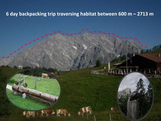
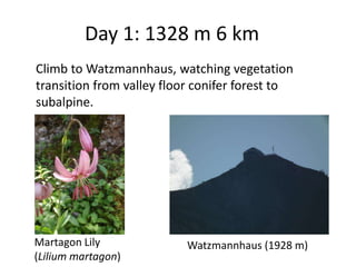
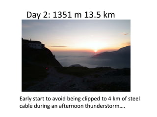
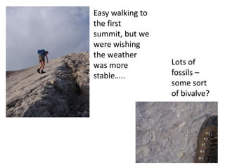
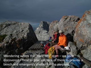
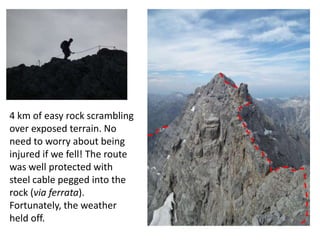
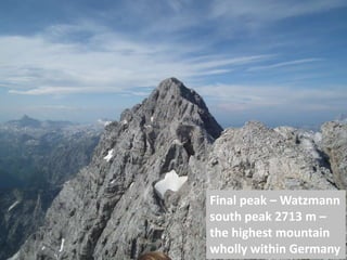
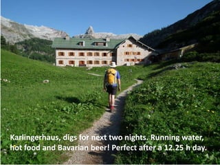
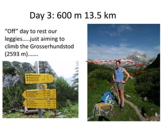
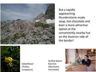
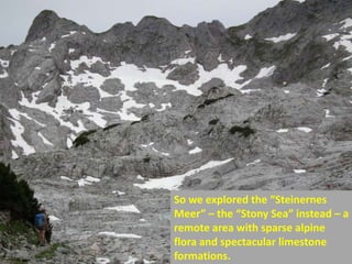
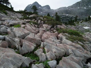
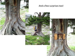
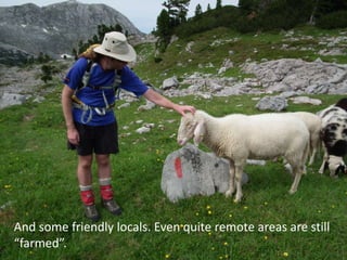
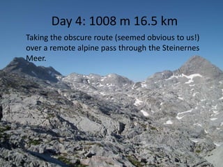
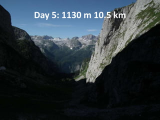
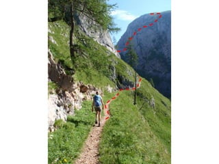
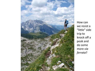
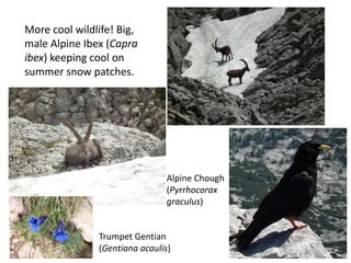
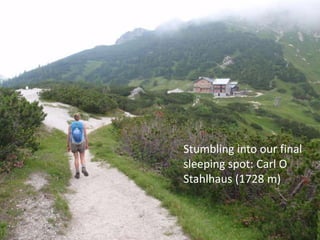
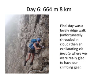
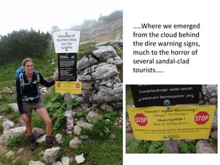
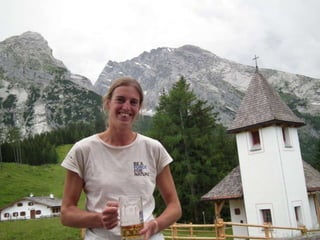
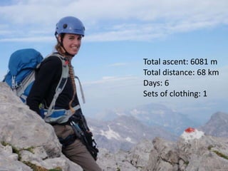
Time for Nature
      2 – 6 July 2012


Hut walking in Berchtesgaden
  National Park, Germany

      Mhairi McFarlane
Southwestern Ontario (London)
6 day backpacking trip traversing habitat between 600 m – 2713 m
Day 1: 1328 m 6 km
Climb to Watzmannhaus, watching vegetation
transition from valley floor conifer forest to
subalpine.


Martagon Lily              Watzmannhaus (1928 m)
(Lilium martagon)
Day 2: 1351 m 13.5 km


Early start to avoid being clipped to 4 km of steel
cable during an afternoon thunderstorm….
Easy walking to
the first
summit, but we
were wishing
the weather
was more          Lots of
stable…..         fossils –
                  some sort
                  of bivalve?
Wondering where the “hard bits” start – we soon
discovered – time to gear up! Nice of them to provide a
bench and emergency shelter for the purpose.
4 km of easy rock scrambling
over exposed terrain. No
need to worry about being
injured if we fell! The route
was well protected with
steel cable pegged into the
rock (via ferrata).
Fortunately, the weather
held off.
Yup, it
 was as
exposed
  as it
 looks!
Final peak – Watzmann
south peak 2713 m –
the highest mountain
wholly within Germany
Most mountain tops in the
Alps - even obscure ones -
are marked with a cross, and
many have a summitbook
where you can record your
name and date of ascent.
Karlingerhaus, digs for next two nights. Running water,
hot food and Bavarian beer! Perfect after a 12.25 h day.
Day 3: 600 m 13.5 km
“Off” day to rest our
leggies…..just aiming to
climb the Grosserhundstod
(2593 m)…….
But a rapidly
                        approaching
                        thunderstorm made
                        soup, hot chocolate and
                        beer a more attractive
                        option at the
                        conveniently nearby hut
                        on the Austrian side of
                        the border!


              Stuffed Alpine
Globeflower   Marmot
(Trollius     (Marmotta
europaeus)    marmotta)
So we explored the “Steinernes
Meer” – the “Stony Sea” instead – a
remote area with sparse alpine
flora and spectacular limestone
formations.
And a few surprises too!
And some friendly locals. Even quite remote areas are still
“farmed”.
Alpen Rose                White Dryas (Dryas octopetala)
(Rhododendron ferrugineum)        Cushion Pink (Silene acaulis)


                 Gentian
                 (Gentiana sp)       Snail (Cernuella sp?)
Day 4: 1008 m 16.5 km
Taking the obscure route (seemed obvious to us!)
over a remote alpine pass through the Steinernes
Meer.
Our first of many
Alpine Salamanders
(Salamandra atra)
And our first close encounter with Chamois (Rupicapra
rupicapra) for the trip – it dislodged a cooler-bin sized
rock from the cliff above us which smashed to pieces a
little too close for comfort.
We spent the day (and
in fact most of the trip)
skipping back and forth
over the German –
Austrian border,
marked by these paint
marks, often on obvious
natural features like this
colossal boulder.
We descended to 1290 m, low
     enough to encounter
European Beech (Fagus sylvatica)
Day 5: 1130 m 10.5 km
How can
we resist a
“little” side
trip to
knock off a
peak and
do some
more via
ferrata?
More cool wildlife! Big,
male Alpine Ibex (Capra
ibex) keeping cool on
summer snow patches.


                                Alpine Chough
                                (Pyrrhocorax
                                graculus)


               Trumpet Gentian
               (Gentiana acaulis)
Stumbling into our final
sleeping spot: Carl O
Stahlhaus (1728 m)
Where we once again had to
   support the European
 economy by having a beer
Day 6: 664 m 8 km

            Final day was a
            lovely ridge walk
            (unfortunately
            shrouded in
            cloud) then an
            exhilarating via
            ferrata where we
            were really glad
            to have our
            climbing gear.
….ending at one of the most popular
tourist destinations in southern Germany
 – Kehlsteinhaus, or “The Eagle’s Nest” –
       Hitler’s country retreat………


   Photo credit: http://www.hotelfriesacher.com/ausflug-kehlsteinhaus/?L=1
…..Where we emerged
from the cloud behind
the dire warning signs,
much to the horror of
several sandal-clad
tourists…..
Total ascent: 6081 m
Total distance: 68 km
Days: 6
Sets of clothing: 1
Other points of interest


Seeing Norway Maple,          …..and an Alpine hay
Herb Robert and Garlic        meadow full of [native]
Mustard in their native       Queen Anne’s Lace
habitat….                     (Dauca carota).
LOTS of buildings with photovoltaics (for
 generating electricity from the sun) and solar
panels (for heating water) – Germany is one of
     the few developed countries which has
  reduced its carbon emissions, partly due to
   increases in the renewable energy sector.

Mhairi's time for nature

  • 1.
    Time for Nature 2 – 6 July 2012 Hut walking in Berchtesgaden National Park, Germany Mhairi McFarlane Southwestern Ontario (London)
  • 2.
    6 day backpackingtrip traversing habitat between 600 m – 2713 m
  • 3.
    Day 1: 1328m 6 km Climb to Watzmannhaus, watching vegetation transition from valley floor conifer forest to subalpine. Martagon Lily Watzmannhaus (1928 m) (Lilium martagon)
  • 4.
    Day 2: 1351m 13.5 km Early start to avoid being clipped to 4 km of steel cable during an afternoon thunderstorm….
  • 5.
    Easy walking to thefirst summit, but we were wishing the weather was more Lots of stable….. fossils – some sort of bivalve?
  • 6.
    Wondering where the“hard bits” start – we soon discovered – time to gear up! Nice of them to provide a bench and emergency shelter for the purpose.
  • 7.
    4 km ofeasy rock scrambling over exposed terrain. No need to worry about being injured if we fell! The route was well protected with steel cable pegged into the rock (via ferrata). Fortunately, the weather held off.
  • 9.
    Yup, it wasas exposed as it looks!
  • 10.
    Final peak –Watzmann south peak 2713 m – the highest mountain wholly within Germany
  • 11.
    Most mountain topsin the Alps - even obscure ones - are marked with a cross, and many have a summitbook where you can record your name and date of ascent.
  • 12.
    Karlingerhaus, digs fornext two nights. Running water, hot food and Bavarian beer! Perfect after a 12.25 h day.
  • 13.
    Day 3: 600m 13.5 km “Off” day to rest our leggies…..just aiming to climb the Grosserhundstod (2593 m)…….
  • 14.
    But a rapidly approaching thunderstorm made soup, hot chocolate and beer a more attractive option at the conveniently nearby hut on the Austrian side of the border! Stuffed Alpine Globeflower Marmot (Trollius (Marmotta europaeus) marmotta)
  • 15.
    So we exploredthe “Steinernes Meer” – the “Stony Sea” instead – a remote area with sparse alpine flora and spectacular limestone formations.
  • 17.
    And a fewsurprises too!
  • 18.
    And some friendlylocals. Even quite remote areas are still “farmed”.
  • 19.
    Alpen Rose White Dryas (Dryas octopetala) (Rhododendron ferrugineum) Cushion Pink (Silene acaulis) Gentian (Gentiana sp) Snail (Cernuella sp?)
  • 20.
    Day 4: 1008m 16.5 km Taking the obscure route (seemed obvious to us!) over a remote alpine pass through the Steinernes Meer.
  • 21.
    Our first ofmany Alpine Salamanders (Salamandra atra)
  • 22.
    And our firstclose encounter with Chamois (Rupicapra rupicapra) for the trip – it dislodged a cooler-bin sized rock from the cliff above us which smashed to pieces a little too close for comfort.
  • 23.
    We spent theday (and in fact most of the trip) skipping back and forth over the German – Austrian border, marked by these paint marks, often on obvious natural features like this colossal boulder.
  • 24.
    We descended to1290 m, low enough to encounter European Beech (Fagus sylvatica)
  • 25.
    Day 5: 1130m 10.5 km
  • 27.
    How can we resista “little” side trip to knock off a peak and do some more via ferrata?
  • 28.
    More cool wildlife!Big, male Alpine Ibex (Capra ibex) keeping cool on summer snow patches. Alpine Chough (Pyrrhocorax graculus) Trumpet Gentian (Gentiana acaulis)
  • 29.
    Stumbling into ourfinal sleeping spot: Carl O Stahlhaus (1728 m)
  • 30.
    Where we onceagain had to support the European economy by having a beer
  • 31.
    Day 6: 664m 8 km Final day was a lovely ridge walk (unfortunately shrouded in cloud) then an exhilarating via ferrata where we were really glad to have our climbing gear.
  • 32.
    ….ending at oneof the most popular tourist destinations in southern Germany – Kehlsteinhaus, or “The Eagle’s Nest” – Hitler’s country retreat……… Photo credit: http://www.hotelfriesacher.com/ausflug-kehlsteinhaus/?L=1
  • 33.
    …..Where we emerged fromthe cloud behind the dire warning signs, much to the horror of several sandal-clad tourists…..
  • 35.
    Total ascent: 6081m Total distance: 68 km Days: 6 Sets of clothing: 1
  • 36.
    Other points ofinterest Seeing Norway Maple, …..and an Alpine hay Herb Robert and Garlic meadow full of [native] Mustard in their native Queen Anne’s Lace habitat…. (Dauca carota).
  • 37.
    LOTS of buildingswith photovoltaics (for generating electricity from the sun) and solar panels (for heating water) – Germany is one of the few developed countries which has reduced its carbon emissions, partly due to increases in the renewable energy sector.