Marble is a free and open source virtual globe and world atlas program that can be used across Linux, Windows, and Mac operating systems. It allows users to navigate globally using interactive maps with satellite imagery, topography, streets, and other map types. Marble also provides distance measurement, weather data, star maps, routing, and Wikipedia article lookup via place labels. The application includes educational tools like changing the date and time to view celestial changes.
This C++ code creates a simple Marble globe application without any additional dependencies beyond the Marble and Qt libraries. It initializes a QApplication, creates a MarbleWidget without a parent, sets the OpenStreetMap map theme, displays the widget, and executes the application. The code can then be compiled by linking the Marble and Qt GUI libraries.
Marble is a map application and framework for desktop and mobile platforms. It uses Qt and supports standard map themes as well as planetary maps. Features include routing, elevation profiles, vector rendering, and integration with OpenStreetMap. Marble is free software released under the LGPL license and is an ongoing community project.
Marble is an open source virtual globe and world atlas software that can be used on Linux, Windows, Mac OS X and mobile devices. It allows users to view maps of the Earth with different layers like topographic, satellite and street maps. Users can pan and zoom around the globe, look up places and streets, and click on place labels to view the corresponding Wikipedia article. Marble also features various map projections, support for different file formats like KML and GPX, GPS integration, routing capabilities, and can be extended through plugins.
Marble es un globo virtual de código abierto que permite a los usuarios explorar el mundo de forma interactiva. Proporciona mapas temáticos como mapas topográficos, satelitales y de calles, así como funciones como medir distancias, buscar lugares y ver información de la Wikipedia. Está disponible para sistemas Linux, Windows y Mac OS X y puede usarse con fines educativos o de desarrollo.
Marble is a free and open source virtual globe and world atlas program that can be used across Linux, Windows, and Mac operating systems. It allows users to navigate seamlessly across maps through pan and zoom functions. Maps include satellite imagery, topographic maps, and street maps. Additional features include measuring distances, viewing weather and cloud cover, and accessing Wikipedia articles for locations. The program also supports various map projections and file formats while providing an easy to use interface for education and development purposes.
Marble es un globo virtual y atlas global de código abierto que permite a los usuarios explorar el mundo mediante diferentes mapas temáticos como mapas topográficos, satelitales y de calles. Ofrece funciones como medir distancias, buscar lugares, ver la hora actual y cambiar la fecha para ver el cielo nocturno. Además, soporta múltiples proyecciones, formatos de archivo como KML y GPX, y puede integrarse con aplicaciones a través de su biblioteca.
Marble is a free and open-source virtual globe and world map application for desktop and mobile operating systems. It provides an easy to use map for users as well as a map widget and library for developers. Key features include support for different map themes, planets, projections and file formats. It also offers GPS support, routing, online plugins and more. The latest versions focus on improved performance, offline search and map editing capabilities. Developers are encouraged to join the project and help with features like OpenGL ES support.
The document discusses the history and future plans of Marble, an open source virtual globe and world atlas. It details Marble's origins as a prototype in 2004, its inclusion in KDE in 2006, and releases through 2011. Future plans include improved user interfaces with Qt Quick, vector rendering, OpenGL ES support, and Qt 5 integration to move to true 3D. The document encourages participation to help enhance Marble.
Marble is a map application and software library that is free, open source, and supports various platforms including Windows, Linux, Mac OS X and MeeGo. It provides an easy to use map with features like different map themes, projections, routing, and turn-by-turn navigation. The document encourages joining the Marble team to help develop and improve its mapping capabilities.
This document discusses Marble, an open source map library and application. It can be used by users to learn about places and get directions, and by developers as an easy to integrate map component. Marble works across desktop and mobile platforms like Linux, MacOS, Windows, and MeeGo. New features include routing capabilities, bulk map tile downloading, and blending of map layers. The document calls for community contributions to help further develop Marble.
Marble is a free digital globe and map application for KDE and Qt. It provides an interactive globe and map widget that can be used in various KDE applications. Marble has a small dataset, does not require hardware acceleration, and runs on Linux, Windows and Mac. It supports plugins and new map types can be added. Future plans include vector map tiles, routing support, and using Marble on mobile devices.
The document discusses ideas for improving the Marble map application on Mac OS X. It notes that the current version is Qt-only and distributed via a disk image. Suggestions are made to create a Marble Widget for developers, improve the user interface, and implement Mac-style automatic updates. Enabling current location support is also mentioned, along with questions around which geolocation services to use.
The document discusses routing goals for the Marble software, including finding routes from point A to B using different transportation methods anywhere in the world both with and without internet access. It provides information on routing capabilities in previous versions of Marble/KDE including routing for motor vehicles, bicycles and pedestrians in Europe requiring internet access in version 4.5/0.10, adding alternative routes and offline routing options in version 4.6/0.11, and guidance mode for following routes on mobile devices like the Nokia N900 in version 4.6/0.11. Future goals discussed include offline address search and speed improvements for version 4.7/0.12.
This document discusses the GeoData classes in Marble, which model geographic data. It describes the class hierarchy and features like common properties, geometries, and styles. It covers serialization using GeoDataParser and the Model/View relationship using GeoDataTreeModel. Potential uses are discussed like a file manager, position provider, and routing. Areas for future work are also outlined like improving performance and adding more functionality.
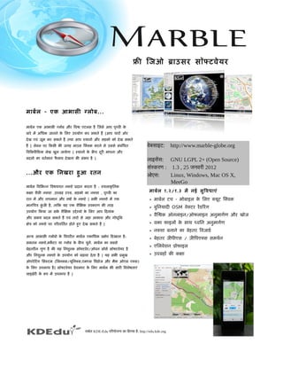
1. मार्बलर्बल - एक आभार्सी ग्लोबल...
मार्बलर्बल एक आभार्सी ग्लोबल और िविश्व एटलस है िजिसे आप पृथ्विी के
बलार्रे में अधिधिक जिार्नने के िलए उपयोग कर सकते हैं |आप चार्रोँ ओर
देख एविं ज़ूम कर सकते हैं तथार् आप स्थार्नो और सड़को को देख सकते
हैं | लेबलल पर िकसी भी जिगह मार्उस िक्लक करने से उससे संबलंिधित
िवििकपीिडियार् लेख खुल जिार्येगार् | स्थार्नो के बलीच दूरी मार्पनार् और
बलदलो कार् वितर्बमार्न फै लार्वि देखनार् भी संभवि है |
...और एक िनखरार् हुआ रतन
मार्बलर्बल िवििभन्न िविषयगत नक्शे प्रदार्न करतार् है : स्थलार्कृ ितक
कक्षार् शैली नक्शार् ,उपग्रह दृश्य, सड़को कार् नक्शार् , पृथ्विी कार्
रार्त में और तार्पमार्न और विषार्र्ब के नक्शे | सभी नक्शो में एक
मार्निचत्र कुं जिी है, तार्िक यह एक शैिक्षक उपकरण की तरह
उपयोग िकयार् जिार् सके शैिक्षक उद्देश्यो के िलए आप िदनार्ंक
और समय बलदल सकते हैं एविं तार्रो से जिड़ार् आकार्श और गोधिूिल
क्षेत्र को नक्शे पर पिरविितर्बत होते हुए देख सकते हैं |
अधन्य आभार्सी ग्लोबलो के िविपरीत मार्बलर्बल एकार्िधिक प्रक्षेप िदखार्तार् है:
समतल नक़्शे,मके टर यार् ग्लोबल के बलीच चुनें. मार्बलर्बल कार् सबलसे
बलेहतरीन गुण है की यह िनशुल्क सॉफ्टविेर/ओपन सोसर्ब सॉफ्टविेयर है
और िनशुल्क नक्शो के उपयोग को बलढ़ार्विार् देतार् है | यह सभी प्रमुख
ऑपरेिटंग िसस्टम (िलनक्स/यूिनक्स,एमएस िविंडिोजि और मैक ओएस एक्स)
के िलए उपलब्धि है| सॉफ्टविेयर डिेविलपर के िलए मार्बलर्बल की सार्री िविशेषतार्एं
लार्इब्रेरी के रूप में उपलब्धि है |
मार्बलर्बल १.२/१.३ में नई सुिविधिार्एं
* मार्बलर्बल टच - मोबलार्इल के िलए क्यूट िक्विक
* बलुिनयार्दी OSM विेक्टर रेंडििरंग
* विैिश्वक ऑनलार्इन/ऑफलार्इन अधनुमार्गर्बण और खोजि
* विक्तार् फ़ार्इलों के सार्थ ध्वििन अधनुमार्गर्बण
* नक्शार् बलनार्ने कार् बलेहतर िविजिार्डिर्ब
* बलेहतर जिीपीएस / जिीिपएक्स समथर्बन
* एिलविेशन प्रोफार्इल
* उपग्रहों की कक्षार्
वेबसाइट: http://www.marble-globe.org
लाइसेंस: GNU LGPL 2+ (Open Source)
संस्करण : 1.3 , 25 जनवरी 2012
ओएस: Linux, Windows, Mac OS X,
MeeGo
माबर्बल KDE-Edu परिरयोजना का िहिस्सा हिै: http://edu.kde.org
फ्री िजिओ ब्रार्उसर सॉफ्टविेयर
2. िविशेषतार्एँ
प्रयोग करने में आसार्न
सहजि ज्ञार्न युक्त नक्शार् चार्रोँ ओर देखने एविं जिूम करने
में उपयोगी है | नक्शार् स्वितः पृष्ठभूिम में डिार्उनलोडि और
हार्डिर्ब िडिस्क पर कै श िकयार् जिार्तार् है |
मार्नक नक्शे
एटलस, उपग्रह,ओपनस्ट्रीटमेप,समतल नक्शार्,रार्त को धिरती,
ऐतितहार्िसक नक्शार्, चंद्रमार् कार् नक्शार् इत्यार्िद |.
नक्शे कार् डिार्टार् (टार्इल सविर्बर लेआउट)
डिार्टार् की एकार्िधिक परतों को िफल्टर के मार्ध्यम से िमलार्यार् एविं
िनिदर्बष्ट िकयार् जिार् सकतार् है| मार्बलर्बल उपयोगकतार्र्ब को नक्शार् बलनार्ने
कार् िविजिार्डिर्ब भी देतार् है | समिथर्बत टार्इल लेआउट योजिनार्ओं में शार्िमल हैं:
• ओपनस्ट्रीटमेप
• गूगल नक़्शे,ओविी नक़्शे
• WMS समथर्बन
• कस्टम सविर्बर लेआउट (XML के मार्ध्यम से िनिदर्बष्ट)
प्रक्षेपण
ग्लोबल, समआयतार्कार्र, मके टर
समिथर्बत फ़ार्इल स्विरूप
/• KML गूगल अधथर्ब(टीएम) उपयोगकतार्र्ब डिेटार्, KMZ समथर्बन नहीं है
, ,• GPX OSM अधितिरक्त स्विरूप प्लगइन के मध्यम से उपलब्धि है
िस्थित प्रदार्तार्
जिीपीएस (जिीपीएसडिी, क्यूट मोिबलिलटी, मीमो 5, िजिओक्लु के मार्ध्यम से)
अधनुमार्गर्बण
उपयोगकतार्र्ब ड्रैग और ड्रार्प के मार्ध्यम से मार्गर्ब डिार्ल सकते है
. तकनीकी िविविरण में शार्िमल हैं:
• विैिश्वक ऑनलार्इन अधनुमार्गर्बण: ,Yours OpenRouteService
• ऑफ़लार्इन अधनुमार्गर्बण: , ,Monav Routino Gosmore
• प्लगइन आधिार्िरत अधनुमार्गर्बण बलैकएण्डि
• टनर्ब बलार्ए टनर्ब नेिविगशन , ध्वििन पिरभ्रमण
• प्रोफार्इल (सबलसे तेजि/छोटार् कार्र, सार्इिकल, पैदल चलने कार् रार्स्तार्)
• विैकिल्पक मार्गर्ब और िबलन्दुओं के मार्ध्यम से मार्गर्ब कार् सुझार्वि
िवििकपीिडियार् एकीकरण
और...
सॉफ्टविेयर डिेविलपर मार्बलर्बल कार् अधपनी अधिप्लके शन में सीधिार् यार् प्लग-इन के
मार्ध्यम से उपयोग कर सकते है|
सार्मुदार्ियक एविं विार्िणिज्यक समथर्बन उपलब्धि है |
अपना रास्ता खोजें और िविश्व का अन्विेषण करें
माबर्बल KDE-Edu परिरयोजना का िहिस्सा हिै: http://edu.kde.org
http://www.marble-globe.org
माबर्बल में KML फाइल US क राज्य दर्शाते हिुए
कई पररतो के साथ OpenSeaMap
नोिकया N900 परर माबर्बल