Manila Board of Realtors Geohazards
•
3 likes•2,408 views

Manila Board of Realtors Geohazards
![Real Estate
Property consisting of land and the buildings on it,
along with its natural resources such as crops,
minerals, or water; immovable property of this nature;
an interest vested in this; (also) an item of real
property; (more generally) buildings or housing in
general.
The business of real estate; the profession of buying,
selling, or renting land, buildings or housing."[1]](data:image/gif;base64,R0lGODlhAQABAIAAAAAAAP///yH5BAEAAAAALAAAAAABAAEAAAIBRAA7)
Recommended
Recommended
More Related Content
What's hot
What's hot (20)
Similar to Manila Board of Realtors Geohazards
Similar to Manila Board of Realtors Geohazards (20)
More from Marho Realty
More from Marho Realty (20)
Recently uploaded
Recently uploaded (20)
Manila Board of Realtors Geohazards
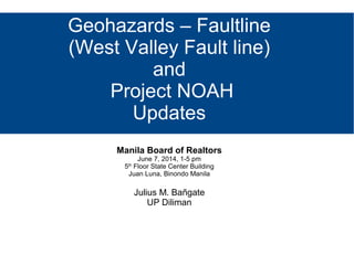
- 1. Geohazards – Faultline (West Valley Fault line) and Project NOAH Updates Manila Board of Realtors June 7, 2014, 1-5 pm 5th Floor State Center Building Juan Luna, Binondo Manila Julius M. Bañgate UP Diliman
- 2. Real Estate Property consisting of land and the buildings on it, along with its natural resources such as crops, minerals, or water; immovable property of this nature; an interest vested in this; (also) an item of real property; (more generally) buildings or housing in general. The business of real estate; the profession of buying, selling, or renting land, buildings or housing."[1]
- 3. Real Estate Broker A real estate broker or real estate agent is a person who acts as an intermediary between sellers and buyers of real estate/real property and attempts to find sellers who wish to sell and buyers who wish to buy.
- 4. Realtor (North America) A person or business that sells or leases out real estate, acting as an agent for the property owner.
- 5. Plate Tectonics Plate tectonics (from the Late Latin tectonicus, from the Greek: τεκτονικός "pertaining to building")[1] a scientific theory that describes the large-scale motion of Earth's lithosphere. The model builds on the concept of continental drift which was developed during the first few decades of the 20th century. The geoscientific community accepted the theory after the concepts of seafloor spreading were developed in the late 1950s and early
- 7. Play plate tectonics video
- 8. Pacific Ring of Fire The Ring of Fire is an area where a large number of earthquakes and volcanic eruptions occur in the basin of the Pacific Ocean. In a 40,000 km (25,000 mi) horseshoe shape, it is associated with a nearly continuous series of oceanic trenches, volcanic arcs, and volcanic belts and/or plate movements. It has 452 volcanoes and is home to over 75% of the world's active and dormant volcanoes.[1] It is sometimes called the circum-Pacific belt or the circum-Pacific seismic belt.http://en.wikipedia.org/wiki/Ring_of_Fire
- 9. Pacific Ring of Fire http://www.rumormillnews.com/cgi-bin/archive.cgi?read=62180
- 10. Earthquakes (also known as a quake, tremor or temblor) is the result of a sudden release of energy in the Earth's crust that creates seismic waves. The seismicity, seismism or seismic activity of an area refers to the frequency, type and size of earthquakes experienced over a period of time.
- 11. http://www.coolgeography.co.uk/GCSE/AQA/Restless %20Earth/Earthquakes/EarthquakeBlockDiagram14.jpg
- 12. Earthquakes Earthquakes are measured using observations from seismometers. The moment magnitude is the most common scale on which earthquakes larger than approximately 5 are reported for the entire globe. The most recent large earthquake of magnitude 9.0 or larger was 9.0 magnitude earthquake in Japan in 2011 (as of March 2014), and it was the largest Japanese earthquake since records began. Intensity of shaking is measured on the modified Mercalli scale. The shallower an
- 15. Earthquakes Earthquakes are measured using observations from seismometers. The moment magnitude is the most common scale on which earthquakes larger than approximately 5 are reported for the entire globe. The most recent large earthquake of magnitude 9.0 or larger was 9.0 magnitude earthquake in Japan in 2011 (as of March 2014), and it was the largest Japanese earthquake since records began. Intensity of shaking is measured on the modified Mercalli scale. The shallower an
- 17. Earthquakes At the Earth's surface, earthquakes manifest themselves by shaking and sometimes displacement of the ground. When the epicenter of a large earthquake is located offshore, the seabed may be displaced sufficiently to cause a tsunami. Earthquakes can also trigger landslides, and occasionally volcanic activity.
- 19. Earthquakes Tectonic earthquakes occur anywhere in the earth where there is sufficient stored elastic strain energy to drive fracture propagation along a fault plane. The sides of a fault move past each other smoothly and aseismically only if there are no irregularities or asperities along the fault surface that increase the frictional resistance. Most fault surfaces do have such asperities and this leads to a form of stick-slip behaviour.
- 20. Magnitude vs Intensity Magnitude and Intensity measure different characteristics of earthquakes. Magnitude measures the energy released at the source of the earthquake. Magnitude is determined from measurements on seismographs. Intensity measures the strength of shaking produced by the earthquake at a certain location. Intensity is determined from effects on people, human structures, and the natural environment.
- 23. Earthquake Fault Types There are three main types of fault, all of which may cause an earthquake: − normal, − reverse (thrust) and − strike-slip. − Normal and reverse faulting are examples of dip-slip, where the displacement along the fault is in the direction of dip and movement on them involves a vertical component. Normal faults occur mainly in areas where the crust is being extended such as a divergent boundary. Reverse faults occur in areas where the crust is being shortened such as at a convergent boundary. Strike-slip faults are steep structures where the two sides of the fault slip horizontally past each other; transform boundaries are a particular type of strike-slip fault. Many earthquakes are caused by movement on faults that have components of both dip-slip and strike-slip; this is known as oblique slip. Reverse faults, particularly those along convergent plate boundaries are associated with the most powerful earthquakes, including almost all of those of magnitude 8 or more. Strike-slip faults, particularly continental
- 24. Fault In geology, a fault is a planar fracture or discontinuity in a volume of rock, across which there has been significant displacement along the fractures as a result of earth movement. Large faults within the Earth's crust result from the action of plate tectonic forces, with the largest forming the boundaries between the plates, such as subduction zones or transform faults. Energy release associated with rapid movement on active faults is the cause of most earthquakes.
- 25. Fault A fault line is the surface trace of a fault, the line of intersection between the fault plane and the Earth's surface. Since faults do not usually consist of a single, clean fracture, geologists use the term fault zone when referring to the zone of complex deformation associated with the fault plane. The two sides of a non-vertical fault are known as the hanging wall and footwall. By definition, the hanging wall occurs above the fault plane and the footwall occurs below the fault.[2] This terminology comes from mining: when working
- 27. Fault Types http://i.livescience.com/images/i/00 0/053/361/original/fault-types.jpg? 1370030748s
- 29. The great East Japan (Tohoku) 2011 earthquake
- 30. The great East Japan (Tohoku) 2011 earthquake http://www.earthobservatory.sg/files/project/images/Tohoku2- bloc_diagramme_japan_earthquakes.jpg
- 31. The great East Japan (Tohoku) 2011 earthquake Schematic side view of the subduction zone and source of the earthquake of March 11th. A tsunami was generated because the motion of the plates pushed and pulled on the ocean floor.
- 32. The great East Japan (Tohoku) 2011 earthquake Click image to view video
- 34. Bohol Earthquake http://2.bp.blogspot.com/- DTDSs7CwbNU/Ul0YJhTJwcI/AAAAAAAAIA0/ HtJ3Y8hek6M/s1600/bohol+quake+2.jpg The 2013 Bohol earthquake occurred on October 15, 2013, at 8:12 a.m. (PST) in Bohol, an island province located in Central Visayas, Philippines.[6] The magnitude of the earthquake at the epicenter was recorded at Mw 7.2, located 6 kilometres (3.7 mi) SW of Sagbayan town, at a depth of 12 kilometres (7.5 mi). [1][7] It affected the whole Central Visayas region, particularly Bohol and Cebu. The quake was felt in the whole Visayas area and as far as Masbate island in the north and Cotabato provinces in southern Mindanao.
- 36. Bohol Earthquake
- 37. Bohol Earthquake
- 38. The Marikina Valley Fault System The Valley Fault System and formerly as the Marikina Valley Fault System is a group of dextral strike-slip[1] fault which extends from San Mateo, Rizal to Taguig City on the south; running through the cities of Makati, Marikina, Parañaque, Pasig and Taguig.[2] http://en.wikipedia.org/wiki/Marikina_Valley_Fault_System
- 39. The Marikina Valley Fault System The fault possesses a threat of a large scale earthquake with a magnitude of 7 or higher[3][4] within the Manila Metropolitan area with death toll predicted to be as high as 35,000[3][4]
- 40. http://4.bp.blogspot.com/- aqyhlWa4dfs/Tk0hGdpVT kI/AAAAAAAABNI/HTyQ _l0KabE/s1600/West_Val ley_Fault_System_hd.jpg West Valley Fault System Website ;)
- 42. Earthquake Scenarios MMIERS STUDY MMDA AUSAID STUDY
- 67. How to prepare for this Comply with requirements imposed by relevant agencies (Phivolcs, MGB, DENR, HLURB) Compliance with provisions of the building code. − Observing the proper easements for fault lines (5 meters) − Apply better methodologies in the design and construction of earthquake resistant/proof structures. − Use of superior materials to ensure structural integrity
- 68. Project Noah Nationwide Operational Assessment of Hazards (NOAH) Under DOST http://noah.dost.gov.ph/
- 69. Project Noah - Mission Undertake disaster science research and development, advance the use of cutting edge technologies and recommend innovative information services in government's disaster prevention and mitigation efforts. Take a multi-disciplinary approach in developing systems, tools, and other technologies that could be operationalized by government to help prevent and mitigate disasters.
- 70. Project NOAH Components Hydromet Sensors Development DREAM-LIDAR 3-D Mapping Project Flood NET-Flood Modeling Project Hazards Information Media Strategic Communication Intervention Disaster Management using WebGIS Enhancing Geo-hazards Mapping through LIDAR Doppler System Development
- 73. Project NOAH @Readysaster Hack for Resilience and Philippine Tech Camp - Hackathon
- 74. Project NOAH @ Readysaster Hack for Resilience Organized in collaboration with Code for Resilience, the World Bank Global Facility for Disaster Reduction and Recovery, and Project NOAH, and was made possible through partnerships with Smart Developer Network, Microsoft Philippines, Google Developer Group, and WhenInManila.com, as well as the support of Smart Bro, Coffee Bean and Tea Leaf, Mozilla Philippines, and Palet Express.
- 75. Mapsafe* will be launched on June 9, 2014 via Project NOAH & the World Bank * a web based tool for disaster assessment and scenario analysis similar to INASAFE shown above
- 76. Other Tools - OpenStreetMap
- 77. Other Tools – OSM Buildings