
Report
Share

Recommended
Landforms and bodies of water
The document discusses physical geography and classifies landforms based on whether they form on continental crust or oceanic crust. It also mentions bodies of water as a category.
Underground Limestone Features
The document discusses different underground limestone features including stalagmites, stalactites, and caverns. Stalagmites form from water deposits on the ground, stalactites form from water deposits on cave ceilings. Caverns are created through chemical weathering which erodes limestone over time. Malham Cove has different rock layers and features that allow for erosion and the formation of caves and underground structures through chemical and water processes.
Bodies Of Water
Oceans, rivers, and lakes are the three main types of bodies of water on Earth. Oceans are large bodies of salt water surrounding continents, with the Pacific being the largest. Rivers are flowing bodies of fresh water that cross land and empty into seas or oceans. Lakes are large bodies of fresh water surrounded by land on all sides, such as Lake Kaweah in Tulare County.
Bodies of Water
The document discusses the key characteristics of major bodies of water: oceans are the largest, covering 70% of Earth's surface and containing salt water; rivers flow towards oceans and other bodies of water, transporting fresh water from rain and snow; streams flow into rivers and are confined within banks; lakes are surrounded by land and can be natural or manmade; and ponds are smaller and more shallow than lakes, also containing fresh water.
Bodies of water
The water cycle describes the continuous movement of water on, above, and below the surface of the Earth. Water can change between liquid, solid, and gas states in this cycle. In its purest form, water is a chemical compound made up of two hydrogen atoms and one oxygen atom. Bodies of flowing water include rivers, creeks, brooks, and canals, which vary in size and flow. Bodies of non-flowing water include oceans, lakes, ponds, reservoirs, sloughs, marshes, and estuaries, and also vary in size and salinity.
Bodies of water
The document discusses different types of bodies of water on Earth. It states that about 3/4 of Earth's surface is covered by water, but only 1/2 cup out of a gallon jug represents the amount of fresh water. The largest oceans are the Pacific, Atlantic, Indian, and Arctic. Lakes are bodies of water surrounded by land, and the Great Lakes are located in Michigan. Rivers contain fresh water and flow into larger bodies of water. Ponds and streams are smaller than lakes and rivers.
Its bodies of water (Galicia)
Galicia is a region in northwestern Spain with over 1500 km of coastline on the Atlantic Ocean and Cantabrian Sea. It has a mild, rainy climate influenced by the seas. The most notable geographical features are its rias, which are coastal inlets formed by drowned river valleys along the coast. The rias support important fishing and aquaculture industries, with over 190 species captured commercially, including octopus, clams, and various fish. Rivers in Galicia, notably the Miño and Sil, provide hydroelectric power and have been important for transportation, irrigation, and human water supply through dams and other infrastructure.
Bodies of water
Power Point done and used to teach 2nd and 3rd Graders in Sciences. (Bodies of water- seas-oceans...)
Karst Landforms in Mallorca
This is a Powerpoint presentation on the Karst Landforms of Mallorca. In this particular landscape you can't find any flora or fauna.
limestone project
The Yorkshire Dales National Park has outstanding scenery formed by limestone geology and erosion over millions of years. Limestone pavement, swallow holes, dry valleys, and features like Malham Cove and Gordale Scar were shaped by water dissolving the limestone. Over a million visitors are attracted annually to this scenic area around the village of Malham, and the impermeable limestone also makes it suitable for building prisons.
Limestone Features And Scenery Of The Yorkshire Dales
The document describes several limestone features found in the Yorkshire Dales National Park in the UK. It explains the limestone pavement at Malham formed from weathering along joints and bedding planes. It also describes how swallow holes allow water to disappear underground, later resurging where impermeable rock is encountered. Dry valleys were left behind by melting glaciers, and Malham Cove and Gordale Scar are limestone ravines formed by water erosion. The land is used residentially, for quarrying, farming, and tourism which brings in £50 million annually.
Limestone Guide
The Yorkshire Dales National Park is the third largest national park in England and Wales known for its outstanding scenery and diverse wildlife. It contains limestone pavements, swallow holes which are sinkholes, and dry valleys formed during the ice age when surface water drained underground. Popular attractions include Malham Cove, a curved limestone cliff, and Goredale Scar, which exposes bare rock faces due to erosion. Land use in the park includes farming, quarrying, tourism focused on walking and cycling, and caving.
Uteach2
Limestone is a porous rock that water can dissolve through solution weathering. The chemical reaction of calcium carbonate + rainwater + carbon dioxide forms calcium bicarbonate and weak carbonic acid, which dissolves the limestone over time. This process enlarges caverns within the rock until the cavern roof collapses, forming a gorge with a stream at the bottom and scree made of broken rock fragments.
Karst
Un karst se produce cuando el agua de lluvia y ríos disuelve rocas solubles como la caliza y el yeso, creando cuevas y otras formas de relieve. La reacción química que causa la disolución se llama carbonatación. Esto ocurre cuando el agua con dióxido de carbono disuelto entra en contacto con la calcita o feldespatos en las rocas. Esto da como resultado paisajes kársticos con diferentes tipos de cavidades superficiales como dolinas y simas, y cavidades subterráneas como cuevas
Emma Geog.
Hurricane Mitch formed in the western Caribbean sea in late October 1998, strengthening to a category five hurricane and becoming the strongest of that year's Atlantic hurricane season. It caused widespread destruction across Central America, killing over 11,000 people through flooding and mudslides as it tore through Nicaragua, Guatemala, and Honduras in particular. The hurricane severely damaged infrastructure like bridges and roads, destroyed homes and farmland, and its aftermath led to diseases spreading as it left many countries in Central America devastated and their development slowed.
Unit Plan Power Point on Landforms
The document outlines a 5-day lesson plan for teaching 4th and 5th grade special education students about landforms and bodies of water. Each day focuses on different landforms and includes activities like class discussions, videos, worksheets and interactive lessons on the SMARTboard. The goal is for students to be able to identify landforms and water bodies and where they are typically found with 90% accuracy after completing the lessons and homework.
Landformspowerpoint
This document outlines a 5-day lesson plan for teaching 4th and 5th grade special education students about landforms and bodies of water. Over the 5 days, students will use technology like videos, websites, and interactive lessons to research and learn about different landforms. Assessment activities include creating posters and collages, participating in online discussions, and taking a test on the fifth day. The goal is for students to be able to identify different landforms and bodies of water with 90% accuracy after completing the lessons and assessments.
Landforms
This document defines and describes various landforms and bodies of water. It explains that bays are areas of water bordered by land on three sides, gulfs are larger than bays and partly surrounded by land, and peninsulas are pieces of land surrounded by water on three sides. Rivers are large flowing bodies of water that usually empty into seas or oceans, and waterfalls occur where rivers fall steeply.
More case studeies
This document provides a list of case study questions about water, landforms, and how people interact with them. The questions cover topics like a river landform created by erosion or deposition, an area affected by flooding or drought, a coastal landform made by the sea, and a coastal management scheme. Learners are asked to name and describe locations for each topic and explain how the landforms were created and how people have used or managed the environments.
United states landmarks
The document provides descriptions of famous United States landmarks, including the Statue of Liberty, Mount Rushmore, Golden Gate Bridge, Empire State Building, Washington Monument, Alamo, Death Valley, Old Faithful, Crater Lake, Four Corners, Niagara Falls, Hoover Dam, Cape Hatteras, Arches National Park, Redwood National Forest, Crater of Diamonds, and Grand Canyon. Each landmark is briefly described in one or two sentences with key details about its location, history, and features.
More Related Content
Viewers also liked
Bodies of Water
The document discusses the key characteristics of major bodies of water: oceans are the largest, covering 70% of Earth's surface and containing salt water; rivers flow towards oceans and other bodies of water, transporting fresh water from rain and snow; streams flow into rivers and are confined within banks; lakes are surrounded by land and can be natural or manmade; and ponds are smaller and more shallow than lakes, also containing fresh water.
Bodies of water
The water cycle describes the continuous movement of water on, above, and below the surface of the Earth. Water can change between liquid, solid, and gas states in this cycle. In its purest form, water is a chemical compound made up of two hydrogen atoms and one oxygen atom. Bodies of flowing water include rivers, creeks, brooks, and canals, which vary in size and flow. Bodies of non-flowing water include oceans, lakes, ponds, reservoirs, sloughs, marshes, and estuaries, and also vary in size and salinity.
Bodies of water
The document discusses different types of bodies of water on Earth. It states that about 3/4 of Earth's surface is covered by water, but only 1/2 cup out of a gallon jug represents the amount of fresh water. The largest oceans are the Pacific, Atlantic, Indian, and Arctic. Lakes are bodies of water surrounded by land, and the Great Lakes are located in Michigan. Rivers contain fresh water and flow into larger bodies of water. Ponds and streams are smaller than lakes and rivers.
Its bodies of water (Galicia)
Galicia is a region in northwestern Spain with over 1500 km of coastline on the Atlantic Ocean and Cantabrian Sea. It has a mild, rainy climate influenced by the seas. The most notable geographical features are its rias, which are coastal inlets formed by drowned river valleys along the coast. The rias support important fishing and aquaculture industries, with over 190 species captured commercially, including octopus, clams, and various fish. Rivers in Galicia, notably the Miño and Sil, provide hydroelectric power and have been important for transportation, irrigation, and human water supply through dams and other infrastructure.
Bodies of water
Power Point done and used to teach 2nd and 3rd Graders in Sciences. (Bodies of water- seas-oceans...)
Karst Landforms in Mallorca
This is a Powerpoint presentation on the Karst Landforms of Mallorca. In this particular landscape you can't find any flora or fauna.
limestone project
The Yorkshire Dales National Park has outstanding scenery formed by limestone geology and erosion over millions of years. Limestone pavement, swallow holes, dry valleys, and features like Malham Cove and Gordale Scar were shaped by water dissolving the limestone. Over a million visitors are attracted annually to this scenic area around the village of Malham, and the impermeable limestone also makes it suitable for building prisons.
Limestone Features And Scenery Of The Yorkshire Dales
The document describes several limestone features found in the Yorkshire Dales National Park in the UK. It explains the limestone pavement at Malham formed from weathering along joints and bedding planes. It also describes how swallow holes allow water to disappear underground, later resurging where impermeable rock is encountered. Dry valleys were left behind by melting glaciers, and Malham Cove and Gordale Scar are limestone ravines formed by water erosion. The land is used residentially, for quarrying, farming, and tourism which brings in £50 million annually.
Limestone Guide
The Yorkshire Dales National Park is the third largest national park in England and Wales known for its outstanding scenery and diverse wildlife. It contains limestone pavements, swallow holes which are sinkholes, and dry valleys formed during the ice age when surface water drained underground. Popular attractions include Malham Cove, a curved limestone cliff, and Goredale Scar, which exposes bare rock faces due to erosion. Land use in the park includes farming, quarrying, tourism focused on walking and cycling, and caving.
Uteach2
Limestone is a porous rock that water can dissolve through solution weathering. The chemical reaction of calcium carbonate + rainwater + carbon dioxide forms calcium bicarbonate and weak carbonic acid, which dissolves the limestone over time. This process enlarges caverns within the rock until the cavern roof collapses, forming a gorge with a stream at the bottom and scree made of broken rock fragments.
Karst
Un karst se produce cuando el agua de lluvia y ríos disuelve rocas solubles como la caliza y el yeso, creando cuevas y otras formas de relieve. La reacción química que causa la disolución se llama carbonatación. Esto ocurre cuando el agua con dióxido de carbono disuelto entra en contacto con la calcita o feldespatos en las rocas. Esto da como resultado paisajes kársticos con diferentes tipos de cavidades superficiales como dolinas y simas, y cavidades subterráneas como cuevas
Emma Geog.
Hurricane Mitch formed in the western Caribbean sea in late October 1998, strengthening to a category five hurricane and becoming the strongest of that year's Atlantic hurricane season. It caused widespread destruction across Central America, killing over 11,000 people through flooding and mudslides as it tore through Nicaragua, Guatemala, and Honduras in particular. The hurricane severely damaged infrastructure like bridges and roads, destroyed homes and farmland, and its aftermath led to diseases spreading as it left many countries in Central America devastated and their development slowed.
Unit Plan Power Point on Landforms
The document outlines a 5-day lesson plan for teaching 4th and 5th grade special education students about landforms and bodies of water. Each day focuses on different landforms and includes activities like class discussions, videos, worksheets and interactive lessons on the SMARTboard. The goal is for students to be able to identify landforms and water bodies and where they are typically found with 90% accuracy after completing the lessons and homework.
Landformspowerpoint
This document outlines a 5-day lesson plan for teaching 4th and 5th grade special education students about landforms and bodies of water. Over the 5 days, students will use technology like videos, websites, and interactive lessons to research and learn about different landforms. Assessment activities include creating posters and collages, participating in online discussions, and taking a test on the fifth day. The goal is for students to be able to identify different landforms and bodies of water with 90% accuracy after completing the lessons and assessments.
Landforms
This document defines and describes various landforms and bodies of water. It explains that bays are areas of water bordered by land on three sides, gulfs are larger than bays and partly surrounded by land, and peninsulas are pieces of land surrounded by water on three sides. Rivers are large flowing bodies of water that usually empty into seas or oceans, and waterfalls occur where rivers fall steeply.
More case studeies
This document provides a list of case study questions about water, landforms, and how people interact with them. The questions cover topics like a river landform created by erosion or deposition, an area affected by flooding or drought, a coastal landform made by the sea, and a coastal management scheme. Learners are asked to name and describe locations for each topic and explain how the landforms were created and how people have used or managed the environments.
United states landmarks
The document provides descriptions of famous United States landmarks, including the Statue of Liberty, Mount Rushmore, Golden Gate Bridge, Empire State Building, Washington Monument, Alamo, Death Valley, Old Faithful, Crater Lake, Four Corners, Niagara Falls, Hoover Dam, Cape Hatteras, Arches National Park, Redwood National Forest, Crater of Diamonds, and Grand Canyon. Each landmark is briefly described in one or two sentences with key details about its location, history, and features.
Viewers also liked (20)
Limestone Features And Scenery Of The Yorkshire Dales
Limestone Features And Scenery Of The Yorkshire Dales
More from nhush
More from nhush (14)
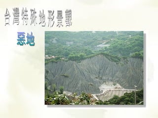
landform
- 1. 台灣特殊地形景觀 惡地
- 2. 月世界
- 4. 土石流
- 5. 南投豐丘土石流 1987 年 1 月 16 日 SPOT 衛星影像與 1996 年 8 月 18 日衛星影像之比較圖
- 7. 壺穴 杉林溪的石井磯
- 8. 暖暖壺穴
- 9. 雪山圈谷
- 11. 火山地形 澎湖七美柱狀玄武岩