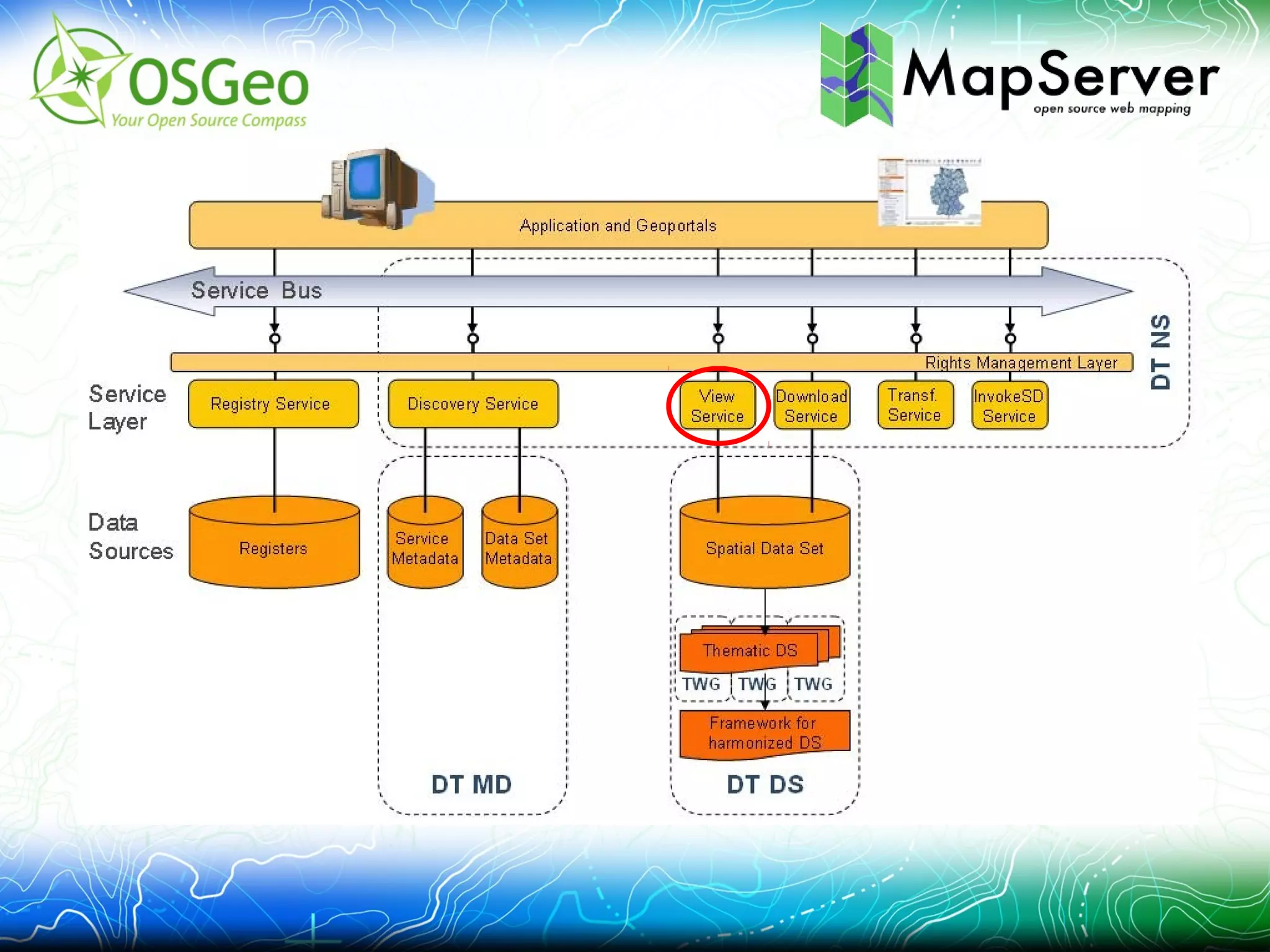
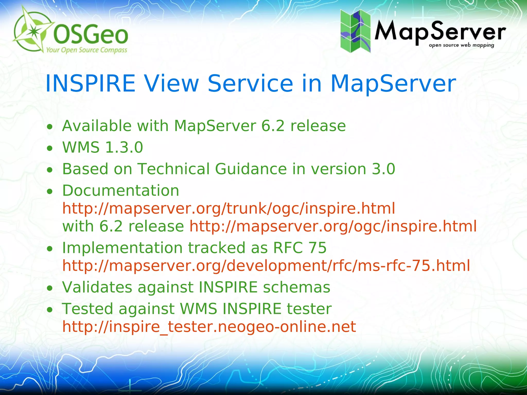
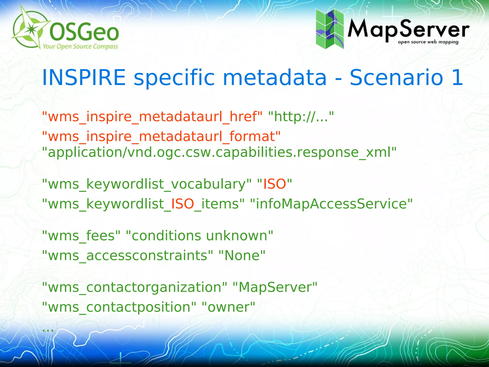
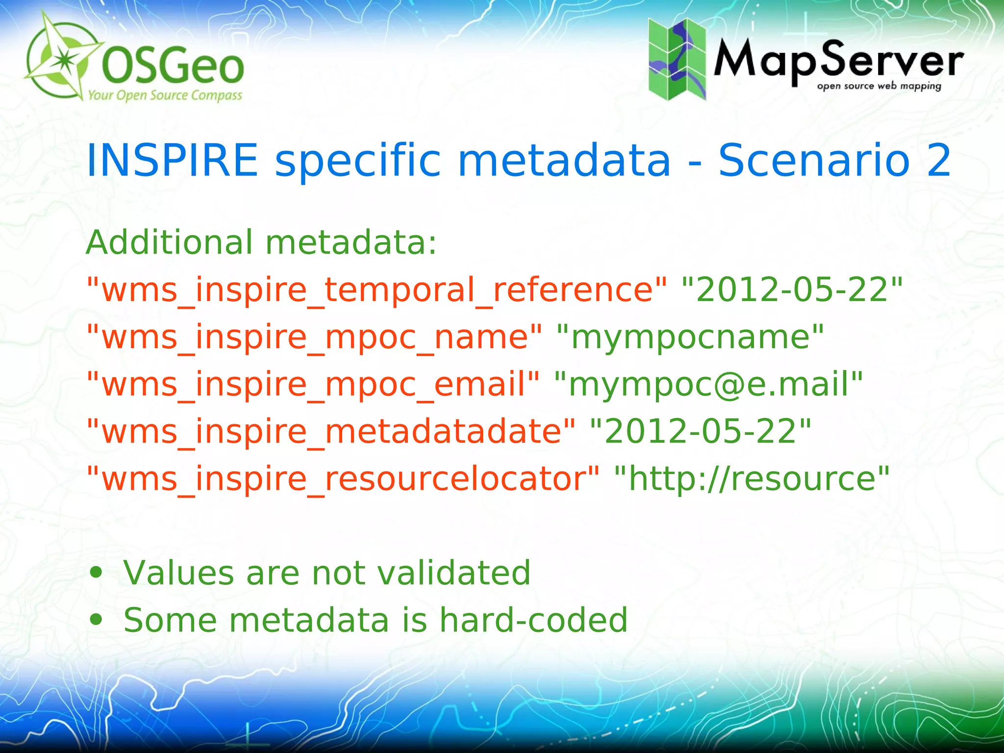
This document provides an overview of implementing an INSPIRE View Service using the open source MapServer platform. It describes activating INSPIRE support in MapServer, adding multi-language support, including INSPIRE specific metadata, and using named group layers. The implementation is available in MapServer 6.2 and has been tested against the INSPIRE WMS tester. It provides INSPIRE compliant metadata and capabilities documents and allows rendering INSPIRE compliant map layers and data.
2013 Vendor, MapQuest Plugins for Leaflet by Jonathan HarahushGIS in the Rockies
Leaflet is a popular open-source JavaScript mapping library that is geared toward developers who want to build lightweight, mobile-friendly Web mapping applications. MapQuest recently released three plugins that enable developers to easily incorporate the most popular MapQuest services -- maps, geocoding, and routing-- into applications built with Leaflet. This session will describe the plugins and demonstrate the functionality included with the MapQuest Maps for Leaflet, MapQuest Geocoding for Leaflet, and MapQuest Routing for Leaflet plugins.
1Spatial: Edinburgh FME World Tour: Property flood risk in Google Earth1Spatial
Thames Water was facing penalties for property flooding due to sewer blockages and collapses. They needed a way to prioritize response based on property attributes. MWH implemented a solution in Google Earth using KML to display flood risk data for each postcode district. Key attributes like property age, basement, usage and access/traffic were shown. FME was used to transform data into the required KML format, setting properties, styles, and regions. The tool is now successfully used in Thames Water's response center to reduce flooded properties.
2011 marks the 10 year anniversary of the GeoServer project with 2010 - 2011 being the most successful year yet. GeoServer continues to grow with an active community and expanding user base. This presentation takes the pulse of the project with a status report of how GeoServer is doing and what to expect in the coming future.
The presentation will start with a "year in review" overviewing some of the new and noteworthy of the past year. This year saw the coming of GeoServer 2.1, a major milestone for the project that brought some exciting new features along with it. Cascading WMS, Virtual Services, SQL Layers/Views, Unit of Measure support for SLD, WMS 1.3, and WPS are just a few of the highlights of 2.1. Attend this presentation to get the entire report of what happened this past year.
The GeoServer developer community continues to remain active with a number of exciting features in the pipeline. The remainder of the presentation will focus on the future with a report of the new developments currently being worked on and what new features and improvements users can expect in 2012.
Whether you are an expert user, a developer, or simply someone who wants to know what GeoServer is and what it can do for you, this talk is for you.
This presentation covers architectural principles for Software defined "Everything", Microservices - their impact on Azure, a Geo-Spatial Fleet analysis using Spark and HDFS on ESRI and FlowBasedProgramming
This document provides information about QinetiQ's Secured Navigation (SecNav) capabilities. It summarizes QinetiQ as a provider of solutions that allow users to reliably receive and trust positioning, navigation and timing information in demanding environments where that information is mission-critical. It mentions capabilities like high accuracy in difficult environments, resilience to interference, robustness to use multiple constellations/frequencies/services, and high dynamics. It also notes QinetiQ's broad skills in GNSS, security and engineering that allow it to provide consulting, research and development, and customized solutions in addition to products.
MapR 5.2: Getting More Value from the MapR Converged Community EditionMapR Technologies
Please join us to learn about the recent developments during the past year in the MapR Community Edition. In these slides, we will cover the following platform updates:
-Taking cluster monitoring to the next level with the Spyglass Initiative
-Real-time streaming with MapR Streams
-MapR-DB JSON document database and application development with OJAI
-Securing your data with access control expressions (ACEs)
The document provides an overview of using HTML5 for mobile mapping applications. It discusses the history and rise of HTML5, how it enables web applications to work across browsers, and its support for mobile functionality. It also covers various HTML5 mapping APIs, using geolocation, common data formats, tile maps and projections, and considerations for designing mobile user interfaces.
The document discusses several projects and components related to geospatial portals. The Metaschool project aims to improve teacher training on digital learning resources. The NaturNet PLUS project transfers knowledge on sustainable tourism to European regions. The document then describes components that make up a geospatial portal, including a metadata catalog, map viewer, content management system, and tools for publishing and managing spatial data.
This document discusses the author's background developing ERP software and their current role. It then discusses concepts like software defined everything, geospatial fleet analysis using big data, and truly reusable code through flow-based programming. The rest of the document provides examples of geospatial analysis on fleet data using techniques like heat mapping, K-means clustering, and analyzing demand variation over time. It highlights how these types of analyses can help optimize resource allocation and identify expansion opportunities.
DSD-INT 2015 - RSS Sentinel Toolbox - J. Manuel Delgado BlascoDeltares
The RSS team provides processing services for Sentinel-1 data exploitation including:
(1) Processing services on demand through the G-POD platform and RSS Cloud Toolbox. These services allow users to process large datasets in a flexible cloud environment.
(2) The SNAP/Sentinels Toolbox which contains tools for processing SAR data from multiple missions including calibration, filtering, coregistration, and interferometry.
(3) Examples showed processing of Sentinel-1A data including TOPSAR interferometry and assembling and processing multiple slices into a georeferenced product subset.
Application scenarios of the SCAPE project at the Austrian National LibrarySven Schlarb
An overview about the different application scenarios at the Austrian National Libraries related to Web Archiving and the Austrian Books Online project.
LIBER Satellite Event, SCAPE by Sven SchlarbSCAPE Project
Sven Schlarb from the Austrian National Libraries gave an overview of the different application scenarios at the Austrian National Libraries related to Web Archiving and the Austrian Books Online project.
The presentation was given at the LIBER Satellite Event on Long term accessibility of digital resources in theory and practice, https://liber2014.univie.ac.at/satellite-event/, in Vienna on 21 May 2014.
This document discusses how ArcGIS supports scientific multidimensional data. It can directly ingest data in formats like netCDF, HDF, and GRIB, and represent the data as raster layers, feature layers, or tables. Users can visualize, analyze, and share the data through tools in ArcGIS Desktop and services. Python can also be used to extend analytical capabilities. ArcGIS is evolving to better support scientific data through capabilities like multidimensional raster and feature layers, on-the-fly processing, and disseminating content as web services.
The document describes a Maps4Finland workshop on common geographic information programming examples. It provides an agenda that includes discussions of content from various Finnish organizations like the National Land Survey of Finland and Statistics Finland. It also gives examples of code samples for creating maps using APIs and standards like OpenLayers, WMS, and GeoJSON. Finally, it discusses handling and converting spatial and non-spatial content between different formats.
The Open Data movement is now moving a step forward, many governments, institutions and business have recently started the process of making information available to citizens and customers. Data is now seen as a powerful instrument to increase transparency in public administration and business on policies. About 80% of this information has a spatial component that is not entirely exploited yet. A range of open source solutions are now available to address this challenge, in this session we will explore their potential and possible applications. The so-called “data deluge” is here.. but we can build good umbrellas.
Drupal Day 2011 - Thinking spatially with your open dataDrupalDay
Talk di Juan Arevalo & Marco Giacomassi | Drupal Day Roma 2011
The Open Data movement is now moving a step forward, many governments, institutions and business have recently started the process of making information available to citizens and customers. Data is now seen as a powerful instrument to increase transparency in public administration and business on policies. About 80% of this information has a spatial component that is not entirely exploited yet. A range of open source solutions are now available to address this challenge, in this session we will explore their potential and possible applications. The so-called “data deluge” is here.. but we can build good umbrellas. Please come to learn more about it!
The document provides an overview of the ArcGIS Editor for OpenStreetMap (OSM). It discusses:
1) The desktop and server components that allow editing OSM data in ArcGIS and creating feature services from OSM data.
2) Key features like downloading global OSM data, creating a large geodatabase, network analysis tools, and uploading edits back to OSM.
3) Effective usage cases like contributing existing datasets to OSM, using ArcGIS tools for analysis and editing, and creating custom services from OSM data.
4) Examples of using the tools for crisis analysis and updating maps of power lines and hiking trails.
This document discusses the GeoServer ecosystem and integrations. GeoServer is an open source geospatial data server that can publish data using open standards. It is used by many organizations to serve maps and geospatial data on the web. The document highlights several integrations and uses of GeoServer including by government agencies to serve satellite imagery, cadastral data, and more. It also discusses commercial support from Boundless and how GeoServer can be deployed in cloud environments and integrated with other open source geospatial tools like GeoNetwork, GeoNode, and World Wind Server.
The document discusses the role of maps in GIS. It notes that maps are at the heart of how geographic information is organized and communicated using GIS. Maps portray different types of geographic data as layered collections that can be combined and analyzed. It emphasizes that unified map designs and shared maps and data across organizations are needed to support the evolution of GIS towards more web-based mapping applications. Community collaboration will be important for developing and sharing high-quality basemaps and operational layers.
MapR 5.2: Getting More Value from the MapR Converged Data PlatformMapR Technologies
End of maintenance for MapR 4.x is coming in January, so now is a good time to plan your upgrade. Please join us to learn about the recent developments during the past year in the MapR Platform that will make the upgrade effort this year worthwhile.
The document discusses MVP OSM, a tool that allows users to identify areas of high activity on OpenStreetMap based on the level of detail. It summarizes how MVP OSM works by importing OSM data into a Spatialite database, analyzing user contributions to identify the most active ("valuable players"), and generating heat maps of activity hotspots. The tool could help recognize highly engaged mappers and understand patterns of contributions on OSM.
Managing director of Klokan Technologies GmbH, a small Swiss company that develops innovative geo applications for cultural heritage institutions. The document discusses Old Maps Online, a project that provides an easy-to-use gateway for searching historical maps from libraries around the world. It allows users to search maps by geographic location on an interactive world map and view high resolution maps from contributing institutions with proper crediting back to the libraries. The project is open to additional map contributors and uses tools like BoundingBox and Georeferencer to help enrich map metadata.
OpenLayers (OL) is an open-source JavaScript library for displaying map data in web applications. It can display data from various sources like GeoJSON, WMS, WFS and supports interactions like querying, filtering and overlaying layers. OL has evolved over the years with new versions introducing features like improved projections support, 3D rendering and compatibility with modern standards. While Leaflet is better for simpler uses due to its large plugin ecosystem, OL is more powerful and flexible for complex GIS applications and supports advanced OGC protocols out of the box.
"INSPIREd computing for EO Based Services" is the title of the presentation made by Paolo Manunta, Head of European Institutions SBU, Planetek Italia.
The presentation, held on November 26th, 2013 during the Big Data workshop organized by Italian Space Agency (ASI).
1. INSPIRE View Service in
MapServer
FOSS4G-CEE 2012, Prague
Stefan Leopold
Stephan Meißl
2. Outline
• Overview INSPIRE View Service
• Overview MapServer
• Implementation & Configuration in MapServer
– Activation of INSPIRE support
– Multi-language support
– INSPIRE specific metadata
– Named group layers
• Conclusions & Outlook
3. Overview of INSPIRE View Service
• Infrastructure for Spatial Information
in Europe - initiative launched by
the European Commission for
solving interoperability issues for
geospatial data
http://inspire.jrc.ec.europa.eu
• Directive as law
• Technical Guidance for View
Services based on WMS 1.1.1
& 1.3.0
4.
5. Overview MapServer
• OSGeo Project – http://mapserver.org
• Widely used Open Source platform for
publishing spatial data to the web
• Fast, flexible, reliable, and highly integratable
• Support of various OGC standards: WMS, WFS,
WCS, SLD, SOS, etc.
• Current release: 6.0.3; 6.2 in preparation
• 16+ active developers; ~300k LoC;
~77 man‑years; IRC #mapserver 30+
• Latest highlights: MapCache, TinyOWS, Github
6. INSPIRE View Service in MapServer
• Available with MapServer 6.2 release
• WMS 1.3.0
• Based on Technical Guidance in version 3.0
• Documentation
http://mapserver.org/trunk/ogc/inspire.html
with 6.2 release http://mapserver.org/ogc/inspire.html
• Implementation tracked as RFC 75
http://mapserver.org/development/rfc/ms-rfc-75.html
• Validates against INSPIRE schemas
• Tested against WMS INSPIRE tester
http://inspire_tester.neogeo-online.net
7. Activation of INSPIRE support
• scenario 1: external metadata: "url"
• scenario 2: embedded metadata: "embed"
WEB
METADATA
"wms_inspire_capabilities" "url"
...
END
END
8. Multi-language support (1/3)
• Provisioning of all supported languages
• Values according to ISO 639-2/B
• First value is default language
WEB
METADATA
…
"wms_languages" "eng,ger,ita"
...
END
END
9. Multi-language support (2/3)
WEB
METADATA
"wms_title.eng" "Transport Network"
"wms_title.ger" "Verkehrsnetz"
"wms_abstract" "myabstract"
...
END
END
...&REQUEST=GetCapabilities&LANGUAGE=eng
10. Multi-language support (3/3)
• Run-time substitution (only CGI)
• DATA & CONNECTION metadata
LAYER
NAME TN.RoadTransportNetwork.RoadArea
DATA "road_%language%.shp"
...
END
...&REQUEST=GetMap&LANGUAGE=eng
12. INSPIRE specific metadata - Scenario 2
Additional metadata:
"wms_inspire_temporal_reference" "2012-05-22"
"wms_inspire_mpoc_name" "mympocname"
"wms_inspire_mpoc_email" "mympoc@e.mail"
"wms_inspire_metadatadate" "2012-05-22"
"wms_inspire_resourcelocator" "http://resource"
• Values are not validated
• Some metadata is hard-coded
13. Named group layers (1/2)
• Via wms_layer_group
• Arbitrary depth
• Named vs. Unnamed
• Supported in GetMap,
GetFeatureInfo, etc.
LAYER
NAME RoadArea
METADATA
"wms_layer_group" "/RoadTransportNetwork"
…
14. Named group layers (2/2)
MAP
NAME TN
…
LAYER unnamed
NAME RoadTransportNetwork
...
LAYER
NAME RoadArea
METADATA
"wms_layer_group" "/RoadTransportNetwork"
…
• Only TN and RoadArea can be requested
• RoadTransportNetwork only used for grouping
16. Conclusions & Outlook (1/2)
• INSPIRE view service support based on
Technical Guidance (v3.0) available with
MapServer 6.2 release
• WMS 1.1.1 on the roadmap
• Bug reports, feature requests, etc. via Github
http://github.org/mapserver/
• General support via mailing lists and IRC
http://mapserver.org/community/index.html
17. Conclusions & Outlook (2/2)
• WCS possibly part of INSPIRE Download Service
– EOxServer: Presentation tomorrow 9:20
• Try it out!
– Check out the MapServer master/trunk and
build the source
http://github.org/mapserver/mapserver/
– Use our demo service and ask for special
support
– Thanks for your feedback
18. Credits
• Edward Nash and Martin Kofahl from DVZ M-V
for their extensive testing
• R3 GIS & EU for financial support
• The whole MapServer Team for their great
guidance and support
19. Stephan Meißl EOX IT Services GmbH
stephan.meissl@eox.at Thurngasse 8/4
1090 Wien
Österreich / Austria
eox.at
Stefan Leopold
stefan.leopold@reflex.at
This work is licensed under a
Creative Commons Attribution-ShareAlike 3.0 Unported License .