
More Related Content
What's hot
Viewers also liked
Viewers also liked (20)
Similar to Harleston Village
Similar to Harleston Village (20)
Harleston Village
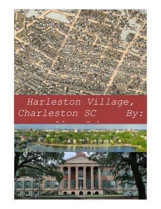
- 1. Harleston Village, Charleston SC By: Alex Cohn
- 2. Harleston Village –Area Character Appraisal Harleston Village is located in the heart of the Downtown Charleston peninsula. Following the creation of the first Charleston suburb, Ansonborough, in 16961, Harleston Village was Charleston’s second and more prominent residential suburb. Created from land granted to Henry Hughes and John Coming in 1961-622, Harleston Village was built on the 17 acres of peninsular land left to Coming’s wife, Affra Harleston Coming, following his death. This land covered the east portion to St. Philip’s parish as “glebe” land (land titled to a church) while the northeastern portion became the “Free School” lands which later became the College of Charleston in the year of 17703. Harleston Village today includes these two sections with the addition of the Mazyck lands located South of Beaufain St. and Wragg’s pasture bound by St. Philip, King, Calhoun and Beaufain Streets. Affra Harleston Coming died about the year of 1699. In her will, dated 28 Dec 1698, Affra bequeathed her estate to her nephews John Harleston and Elias Ball, to be divided equally between them4. In 1770, John Harleston divided Harleston Village into lots along streets which he named after important American Liberty men such as: American rights 1 "Ansonborough Real Estate | Charleston SC Homes for Sale." Ansonborough Charleston SC Real Estate. N.p.,n.d. Web. 24 Nov. 2014. <http://www.locountry.com/ansonborough.html>. 2 "CCPL - Charleston County Public Library - South, Carolina." CCPL - Charleston County Public Library - South, Carolina.N.p.,n.d. Web. 24 Nov. 2014. <http://ccpl.org/content.asp?id=15842&action=detail&catID=6062&parentID=6046>. 3 Poston, Jonathan H. The Buildings of Charleston: A Guide to the City's Architecte. Columbia, SC: U of South Carolina, 1997. Print. 4 "Affra Harleston." Low Country Africana Affra Harleston Comments. N.p.,n.d. Web. 24 Nov. 2014. <http://www.lowcountryafricana.com/affra-harleston/>.
- 3. defender William Pitt, South Carolina Assembly members John Rutledge, Thomas Lynch, and Christopher Gadsden, and Customs Collector/member of the Governor’s Council Hector Beringer De Beaufain. With the opening of Glebe Street in 1797, 37 lots became open for lease with most still in the hands of the perish. The present day Glebe lands contain a few pre-revolutionary dwellings such as the Minister’s (now Bishop’s) House on 89 Wentworth Street with only a few pre-1775 homes remaining5. As previously mentioned, Harleston Village is located on the central Eastern side of the Charleston Peninsula. Harleston village is bounded on the North by the South side of Calhoun Street and bounded on the South by the North side of Broad Street. From the East, Harleston Village is bounded by the Western side of king street and ends on the West at Lockwood Drive (the western edge of the peninsula). In this relatively square area of the peninsula, 9 streets laid out in a grid style, run through the center of the village. These include Wentworth, Montagu, and Bull Streets running from the East to West, and Pitt, Coming, Smith, Rutledge, Lynch (Now named Ashley), Gadsden, and Barre Streets running from the North to South6. The neighborhood that is Harleston Village has evolved considerably over the time of its existence. With the exception of its industrial history of Thomas Bennett Sr. and Daniel Cannon’s lumber mill in the late 18th century on the western side of the neighborhood, Harleston Village owes much of its development to its 5 Poston, Jonathan H. The Buildings of Charleston: A Guide to the City's Architecte. Columbia, SC: U of South Carolina, 1997. Print. 6 "The Downtown Charleston Neighborhoods: Harleston Village." Charleston SC Real Estate Blog. N.p.,n.d. Web. 24 Nov. 2014. <http://www.carolinajoe.com/blog/index.cfm/2010/6/9/The- Downtown-Charleston-Neighborhoods---Part-1>.
- 4. diverse population. Harleston Village was built on the highest portion of land on the peninsula and meant to be mainly residential. The College of Charleston attracted a small professorial group to the neighborhood while Charleston’s antebellum intellectuals also lived there including essayist and poet Hugh Swinton Legare, author William Rivers, and progressive leader Christopher Gustavus Memminger. Coming St., starting from the north of the peninsula and ending at Beaufain St., became the most popular street for Charleston’s “Free Black” (Mulatto Elites as they called themselves) population in the years before 18617. The first census, in 1790, found 8,089 white persons, 7,684 slaves, and 586 free blacks in Charleston. This tells us that very early in Charleston's history free blacks constituted nearly 3.6% of the city's population. By 1861 free blacks comprised 7.8% of Charleston's population8. This growing population of free blacks before the Civil War shows how progressive of a city Charleston was and added a lot to its diversity and culture compared to any other South Carolina city. One major urban planning event that impacted Harleston Village significantly (and positively) was the filling of Bennett Mill Pond between 1880 and 19009. This allowed for an extension of Rutledge and Ashley (Lynch) Avenues, which gave rise to the creation of Cannon Park. Numerous new lots became available and development occurred around the new public space including the famous Colonial 7 Poston, Jonathan H. The Buildings of Charleston: A Guide to the City's Architecte. Columbia, SC: U of South Carolina, 1997. Print. 8 "Charleston SC Free Blacks – A Demographic Overview." South Carolina SC.N.p.,n.d. Web. 24 Nov. 2014. <http://www.sciway.net/hist/chicora/freepersons.html>. 9 "CCPL - Charleston County Public Library - South, Carolina." CCPL - Charleston County Public Library - South, Carolina.N.p.,n.d. Web. 24 Nov. 2014. <http://ccpl.org/content.asp?id=15649&action=detail&catID=6026&parentID=5747>.
- 5. Lake, which has brought the city much positive attention. Also, the Harleston Green Club, the first organized golf club in America played their first game in this area of Harleston Village. Evolution of the village continued into the 20th century with the filling of areas after World War II along the Ashley River. The College of Charleston has had a major impact in the development of Harleston Village. The college has expanded across the Glebe lands and into the eastern end of Harleston Village. Over the years, The College of Charleston has restored numerous buildings across the campus, closed streets such as College and Green Streets, and demolished buildings along St. Philip and George Streets. Since its creation in 1770, Harleston Village has gone through thousands of redevelopment, preservation/restoration, and urban planning projects. Dating back to May of 1961, all property west of coming street, through east side of Rutledge to South side of Calhoun to broad, was available for commercial uses. According to a flyer entitled “Selling Out” found in the Harleston Village vertical file at the Charleston County Public Library, apparently the residents of Harleston Village did not think this was a fantastic idea. “…the signatures of more than 200 property owners who have requested the re-classification of this area from “B” to “A” residential should be the first and most important consideration of the authorities. Who knows more about the proper use of a building than the man who owns it?10” This flyer is significant to understanding the city preservation initiatives because it shows the expressed concern of development by the residents of this area and how 10 Postand Courier article fromMay 1961 found in the CCPL South Carolina History Room vertical file.
- 6. an influx of commerce and industry would impact the “A” classification of the residential neighborhood. Also found in the Harleston Village Vertical File was a Post and Courier article from May 14th, 2008 entitled “30 new Homes for Old City.” This article discussed the proposal from Developer Warren Irving’s plans of the construction of 30 new homes on the old Lumber yard property by Alberta Long Lake ranging in size from 2,500 to 4,000 square feet of heated area. “Irving has worked with Atlanta- based Summerour & Associates Architects Inc. to design a project he feels is in keeping with Harleston Village.” Irving’s plans received very much positive feedback from the community and the Harleston Village Neighborhood Association. A newer concern in the city stems from an ordinance amending the city's zoning regulations to add a new section, Section 54-946 “Regulating Government- Initiated Downzoning.” The ordinance would require the City of Charleston to “pay property owners compensation in the amount of the reduction in fair market value of real property caused by any future, new or amended zoning ordinances and land use regulations, even if those values end up rising later.11” Since 1931, the City has been managed through a planning and zoning ordinance that included the nation's first historic preservation ordinance that became a model for the nation. Over time, the zoning ordinance has changed as Charleston has changed. The historic districts have expanded; new ideas such as height ordinances have emerged; the locations of hotels are regulated; the hours of 11 "Preservation Society of Charleston South Carolina." Preservation Society of Charleston South Carolina. N.p.,n.d. Web. 24 Nov. 2014. <http://www.preservationsociety.org/program_currentdetail.asp?icID=65>.
- 7. operation of certain businesses are restricted; the uses of properties are controlled to ensure compatibility with adjacent properties and neighborhoods12. All neighborhoods in the Historic District of Charleston all remain under the same law. The Urban Design and Preservation division is responsible for administration of the Board of Architectural Review (BAR) within Charleston’s historic districts and Landmark Overlay properties. It investigates new proposed projects and violations of the preservation ordinance within that purview. The division is also responsible for the administration of the Design Review Board (DRB), which oversees the design and alterations of properties outside the city’s historic districts. The Urban Design and Preservation division assists and offers guidance for the community on matters of historic preservation and urban design13. The Architectural aspect of Harleston Village is relatively diverse. Throughout the early 19th century, lots were divided from larger tracts and dwellings, mostly of the single house plan, were constructed. In the 1840s and 1850s, Harleston Village experienced an Architectural boom with the construction of many residences in Greek revival, Gothic, Italianate, antebellum/neoclassical and Georgian styles based on side-hall, double parlor plans14. One of the few rows of townhouses in Charleston, Bee’s Row, was constructed on Bull Street. Churches such as the Grace Episcopal Church built on St. Michael’s portion of the Glebe lands, and 12 "Preservation Society of Charleston South Carolina." Preservation Society of Charleston South Carolina. N.p.,n.d. Web. 24 Nov. 2014. <http://www.preservationsociety.org/program_currentdetail.asp?icID=65>. 13 "Welcome to an Engaged Community." Charleston, SC. N.p.,n.d. Web. 24 Nov. 2014. <http://www.charleston-sc.gov/index.aspx?nid=292>. 14 Poston, Jonathan H. The Buildings of Charleston: A Guide to the City's Architecte. Columbia, SC: U of South Carolina, 1997. Print.
- 8. the Old Bethel United Methodist Church marked the North and South boundaries of the neighborhood. Postbellum industrialists, following the lead of William Ashmead Courtenay, often lived in Harleston Village either retrofitting old homes with Victorian details and materials or constructing new residences. There are a myriad of significant buildings and dwellings in the Harleston Village neighborhood. Some include the Old City Jail on Frankin Street, the Minister’s (bishop’s) House at 87-89 Wentworth St. (connected homes), the William Blacklock House at 18 Bull St., the Isaac Jenkins Mikell House at 94 Rutledge, and the College of Charleston’s Randolph Hall, all of which were built in a melting pot of different styles/cultures during a wide range of generations and have greatly impacted this city and the world of preservation.
- 9. Appendix Maps: Parks/ Landmarks: Google Map of Harleston Village’s present day boundaries Halsey Map drawing of Harleston Village including Harleston Land, Glebe land, free school land, Wragg’s Pasture, and Mazyck land Colonial Lake built after the filling of Bennett Mill Pond between Rutledge and Ashley avenues Cannon Park on Rutledge Avenue. Also the site of the Charleston Museum, which mysteriously burned down in October 1981 The Old City Jail at 21 Magazine St., which was operational from1802 until 1939, housed Charleston's most infamous criminals, and then during the Civil War, Federal prisoners of war.
- 10. Churches: Important Buildings/ Dwellings: Grace Episcopal Church at 98 Wentworth Street- Glebe Land Old Bethel United Methodist Church at 222 Calhoun Street- North boundary of Harleston Village. Constructed in 1797 by the congregation of the church on Cumberland Street but later moved to make way for a new Bethel United Methodist Church Randolph Hall, built in 1828–29, is one of the oldest college buildings still in use in the U.S. Named for the 11th president of the College (Harrison Randolph), Randolph Hall served as the main academic building on campus for many years. It was built in Greek Revival Style and has been featured in a couple major motion pictures and tv shows such as The Patriot, The Notebook, Dear John, General Hospital, etc. due to its historic look and beauty. In 1881, a wealthy cotton merchant named Francis Silas Rodgers set out to build an elegant home in Charleston, S.C., worthy of his family of 13 and he did just that. This Second Empire Victorian style Mansion, now called Wentworth Mansion, is now an elegant Charleston Hotel and restaurant for tourists to endure just what Rodgers had in mind for a Charleston lifestyle. After the old Bethel United Methodist Church was moved, this new Bethel was constructed in a simple temple form Greek revival church featuring 6 Doric columns supporting a pedimented portico
- 11. This set of elegant Italianate row houses, called Bee’s Row is the only row of townhouses in Harleston Village. Located at 87-89 Wentworth St. is the Minister’s (Bishop’s) House, which is actually two connected homes constructed at the same time and is one of a few pre-1775 dwellings left in Harleston Village. The Isaac Jenkins Mikell House is a massive Greek revival residence in the style of grand Italian villa that was built in 1853- 1854 at 94 Rutledge Avenue by Edisto Island cotton planter Isaac Jenkins Mikell for his third wife, Mary Martha Pope. It is now home to the stars of Bravo TV’s SouthernCharm. Named After William Blacklock and located at 18 Bull St., this mansion was built in 1800, and is one of the United States' most important Federal/Adamesque houses. The house is two stories of brick on a high brick basement. The facade features a large lunette in the pediment, openings in blind arches, delicate tracery, and a double flight of iron-railed steps.