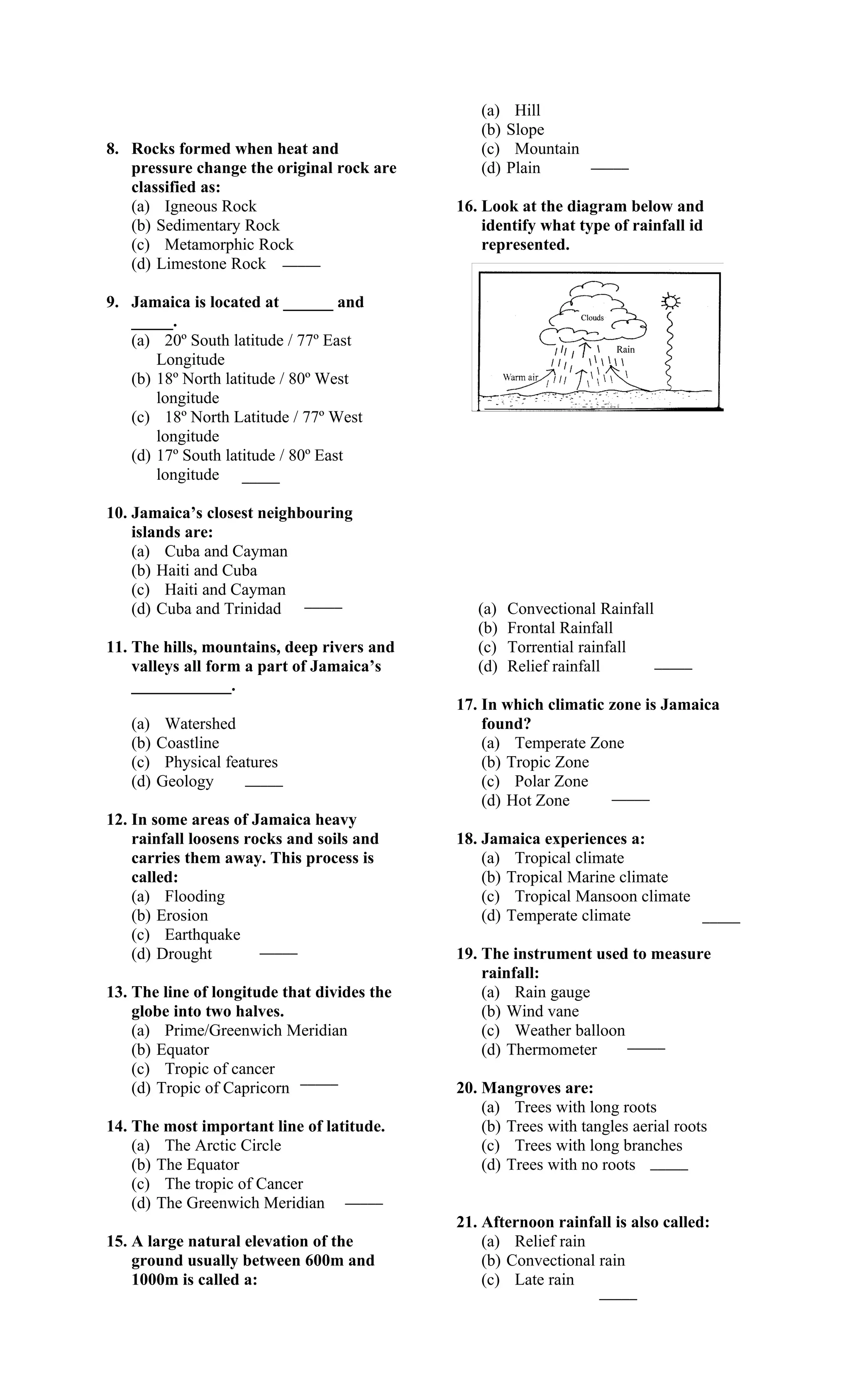
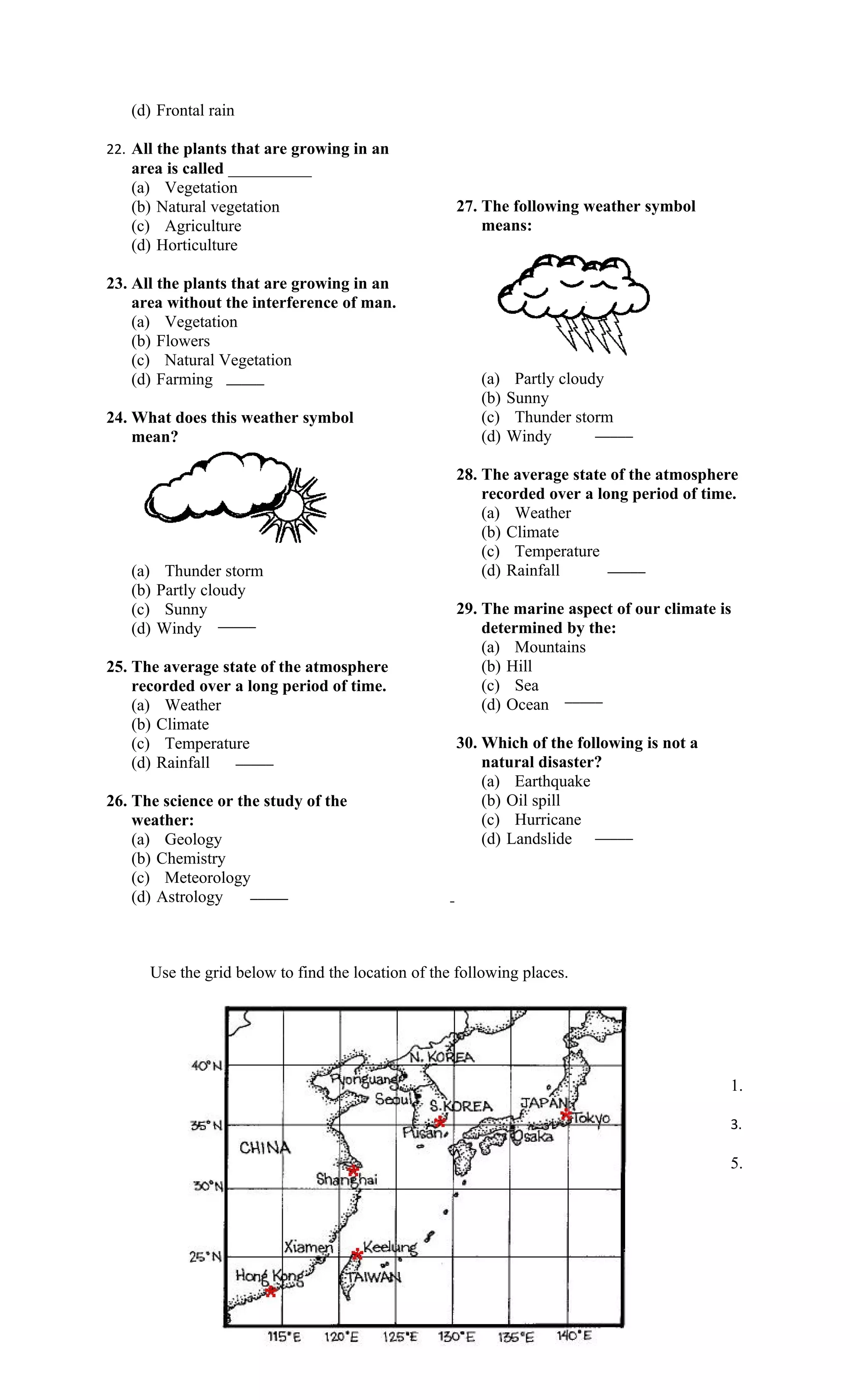
VERE TEC HN ICAL HIGH SC HOOL


                              SOCIAL STUDIES E-TEST
                                      GRADE: 8


Student’s Name:   _____________________________


Class: ___________________


Date: __________________


             Mr. D. Gooden
Instructors: ______________


Instructions: Answer ALL questions.
Use the words below to fill the blank spaces and complete the paragraph.


Write the letter that best describes your response to the questions below on the line
provided.

                                                                        _____

1. The position of a place is called its:              (c) Zoology          _____
                                                       (d) Agronomy
    (a) Surface
    (b) Location                                    5. The outer layer of the earth where we
    (c) Longitude                                      live:
                        _____
    (d) Locality                                       (a) Core
                                                       (b) Mantle
2. Instrument use to locate places:                    (c) Crust
                                                                        _____
   (a) Microscope                                      (d) Inner Core
   (b) Compass
   (c) Cardiograph
                        _____                       6. Low lands between hills or
   (d) Ruler
                                                       mountains:
3. The body of water that surrounds                    (a) Valleys
   Jamaica is called the:                              (b) Depression
   (a) Atlantic Ocean                                  (c) Sinkhole
   (b) Pacific Ocean                                   (d) Mountain    _____
   (c) Red sea
   (d) Caribbean Sea _____                          7. Limestone in a/an:
                                                       (a) Volcanic Rock
                                                       (b) Sedimentary Rock
4. The science or study of rocks:                      (c) Metamorphic Rock
                                                                            _____
   (a) Geology                                         (d) Igneous Rock
   (b) Meteorology
(a)    Hill
                                                (b)   Slope
8. Rocks formed when heat and                   (c)    Mountain
   pressure change the original rock are        (d)   Plain     _____
   classified as:
   (a) Igneous Rock                          16. Look at the diagram below and
   (b) Sedimentary Rock                          identify what type of rainfall id
   (c) Metamorphic Rock                          represented.
   (d) Limestone Rock _____

9. Jamaica is located at ______ and
   _____.
   (a) 20º South latitude / 77º East
       Longitude
   (b) 18º North latitude / 80º West
       longitude
   (c) 18º North Latitude / 77º West
       longitude
   (d) 17º South latitude / 80º East
       longitude _____

10. Jamaica’s closest neighbouring
    islands are:
    (a) Cuba and Cayman
    (b) Haiti and Cuba
    (c) Haiti and Cayman
    (d) Cuba and Trinidad _____                 (a)   Convectional Rainfall
                                                (b)   Frontal Rainfall
11. The hills, mountains, deep rivers and       (c)   Torrential rainfall
    valleys all form a part of Jamaica’s        (d)   Relief rainfall       _____
    ____________.
                                             17. In which climatic zone is Jamaica
   (a)    Watershed                              found?
   (b)   Coastline                               (a) Temperate Zone
   (c)    Physical features                      (b) Tropic Zone
   (d)   Geology      _____                      (c) Polar Zone
                                                 (d) Hot Zone      _____
12. In some areas of Jamaica heavy
    rainfall loosens rocks and soils and     18. Jamaica experiences a:
    carries them away. This process is           (a) Tropical climate
    called:                                      (b) Tropical Marine climate
    (a) Flooding                                 (c) Tropical Mansoon climate
    (b) Erosion                                  (d) Temperate climate        _____
    (c) Earthquake
    (d) Drought        _____                 19. The instrument used to measure
                                                 rainfall:
13. The line of longitude that divides the       (a) Rain gauge
    globe into two halves.                       (b) Wind vane
    (a) Prime/Greenwich Meridian                 (c) Weather balloon
                                                                     _____
    (b) Equator                                  (d) Thermometer
    (c) Tropic of cancer
                            _____
    (d) Tropic of Capricorn                  20. Mangroves are:
                                                 (a) Trees with long roots
14. The most important line of latitude.         (b) Trees with tangles aerial roots
    (a) The Arctic Circle                        (c) Trees with long branches
    (b) The Equator                              (d) Trees with no roots _____
    (c) The tropic of Cancer
    (d) The Greenwich Meridian _____
                                             21. Afternoon rainfall is also called:
15. A large natural elevation of the             (a) Relief rain
    ground usually between 600m and              (b) Convectional rain
    1000m is called a:                           (c) Late rain
                                                                   _____
(d) Frontal rain

22. All the plants that are growing in an
   area is called __________
   (a) Vegetation
   (b) Natural vegetation                           27. The following weather symbol
   (c) Agriculture                                      means:
   (d) Horticulture

23. All the plants that are growing in an
    area without the interference of man.
    (a) Vegetation
    (b) Flowers
    (c) Natural Vegetation
    (d) Farming _____                                   (a)    Partly cloudy
                                                        (b)   Sunny
24. What does this weather symbol                       (c)    Thunder storm
    mean?                                               (d)   Windy        _____

                                                    28. The average state of the atmosphere
                                                        recorded over a long period of time.
                                                        (a) Weather
                                                        (b) Climate
                                                        (c) Temperature
   (a)    Thunder storm                                 (d) Rainfall      _____
   (b)   Partly cloudy
   (c)    Sunny                                     29. The marine aspect of our climate is
   (d)   Windy _____                                    determined by the:
                                                        (a) Mountains
25. The average state of the atmosphere                 (b) Hill
    recorded over a long period of time.                (c) Sea
                                                                  _____
    (a) Weather                                         (d) Ocean
    (b) Climate
    (c) Temperature                                 30. Which of the following is not a
    (d) Rainfall  _____                                 natural disaster?
                                                        (a) Earthquake
26. The science or the study of the                     (b) Oil spill
    weather:                                            (c) Hurricane
    (a) Geology                                         (d) Landslide _____
    (b) Chemistry
    (c) Meteorology
    (d) Astrology    _____


      Use the grid below to find the location of the following places.


                                                                                          1.

                                                                                          3.

                                                                                          5.
5. Tokyo________________________


              Define the following terms:

              Latitude___________________________________________________________

              _________________________________________________________________

              _

              Longitude_________________________________________________________

              _________________________________________________________________

              _


              Label the diagram below by naming the major lines of latitude.


                                                                     ______________________________

                                                                     ______________________________

                                                                     ______________________________

                                                                     ______________________________

                                                                     ______________________________


 Name and describe the THREE types of rocks.

1.   ____________________________________________________________________________________

     ____________________________________________________________________________________

     ____________________________________________________________________________________

     ____________________________________________________________________________________


2.   ____________________________________________________________________________________

     ____________________________________________________________________________________

     ____________________________________________________________________________________

     ____________________________________________________________________________________


3    ____________________________________________________________________________________

     ____________________________________________________________________________________

   ____________________________________________________________________________________
Name ONE Caribbean country that is affected by volcanoes. _____________________________
     ____________________________________________________________________________________
Give the meaning of the terms:

  I.   Climate_________________________________________________________________________
              _________________________________________________________________________

 II.         _________________________________________________________________________
       Weather
              _________________________________________________________________________


       Label and write the use of the weather instruments below.


       ______________________                             ____________________________


                                 __________________________

Grade8e test-120311084156-phpapp01 (3)

  • 1.
    VERE TEC HNICAL HIGH SC HOOL SOCIAL STUDIES E-TEST GRADE: 8 Student’s Name: _____________________________ Class: ___________________ Date: __________________ Mr. D. Gooden Instructors: ______________ Instructions: Answer ALL questions.
  • 2.
    Use the wordsbelow to fill the blank spaces and complete the paragraph. Write the letter that best describes your response to the questions below on the line provided. _____ 1. The position of a place is called its: (c) Zoology _____ (d) Agronomy (a) Surface (b) Location 5. The outer layer of the earth where we (c) Longitude live: _____ (d) Locality (a) Core (b) Mantle 2. Instrument use to locate places: (c) Crust _____ (a) Microscope (d) Inner Core (b) Compass (c) Cardiograph _____ 6. Low lands between hills or (d) Ruler mountains: 3. The body of water that surrounds (a) Valleys Jamaica is called the: (b) Depression (a) Atlantic Ocean (c) Sinkhole (b) Pacific Ocean (d) Mountain _____ (c) Red sea (d) Caribbean Sea _____ 7. Limestone in a/an: (a) Volcanic Rock (b) Sedimentary Rock 4. The science or study of rocks: (c) Metamorphic Rock _____ (a) Geology (d) Igneous Rock (b) Meteorology
  • 3.
    (a) Hill (b) Slope 8. Rocks formed when heat and (c) Mountain pressure change the original rock are (d) Plain _____ classified as: (a) Igneous Rock 16. Look at the diagram below and (b) Sedimentary Rock identify what type of rainfall id (c) Metamorphic Rock represented. (d) Limestone Rock _____ 9. Jamaica is located at ______ and _____. (a) 20º South latitude / 77º East Longitude (b) 18º North latitude / 80º West longitude (c) 18º North Latitude / 77º West longitude (d) 17º South latitude / 80º East longitude _____ 10. Jamaica’s closest neighbouring islands are: (a) Cuba and Cayman (b) Haiti and Cuba (c) Haiti and Cayman (d) Cuba and Trinidad _____ (a) Convectional Rainfall (b) Frontal Rainfall 11. The hills, mountains, deep rivers and (c) Torrential rainfall valleys all form a part of Jamaica’s (d) Relief rainfall _____ ____________. 17. In which climatic zone is Jamaica (a) Watershed found? (b) Coastline (a) Temperate Zone (c) Physical features (b) Tropic Zone (d) Geology _____ (c) Polar Zone (d) Hot Zone _____ 12. In some areas of Jamaica heavy rainfall loosens rocks and soils and 18. Jamaica experiences a: carries them away. This process is (a) Tropical climate called: (b) Tropical Marine climate (a) Flooding (c) Tropical Mansoon climate (b) Erosion (d) Temperate climate _____ (c) Earthquake (d) Drought _____ 19. The instrument used to measure rainfall: 13. The line of longitude that divides the (a) Rain gauge globe into two halves. (b) Wind vane (a) Prime/Greenwich Meridian (c) Weather balloon _____ (b) Equator (d) Thermometer (c) Tropic of cancer _____ (d) Tropic of Capricorn 20. Mangroves are: (a) Trees with long roots 14. The most important line of latitude. (b) Trees with tangles aerial roots (a) The Arctic Circle (c) Trees with long branches (b) The Equator (d) Trees with no roots _____ (c) The tropic of Cancer (d) The Greenwich Meridian _____ 21. Afternoon rainfall is also called: 15. A large natural elevation of the (a) Relief rain ground usually between 600m and (b) Convectional rain 1000m is called a: (c) Late rain _____
  • 4.
    (d) Frontal rain 22.All the plants that are growing in an area is called __________ (a) Vegetation (b) Natural vegetation 27. The following weather symbol (c) Agriculture means: (d) Horticulture 23. All the plants that are growing in an area without the interference of man. (a) Vegetation (b) Flowers (c) Natural Vegetation (d) Farming _____ (a) Partly cloudy (b) Sunny 24. What does this weather symbol (c) Thunder storm mean? (d) Windy _____ 28. The average state of the atmosphere recorded over a long period of time. (a) Weather (b) Climate (c) Temperature (a) Thunder storm (d) Rainfall _____ (b) Partly cloudy (c) Sunny 29. The marine aspect of our climate is (d) Windy _____ determined by the: (a) Mountains 25. The average state of the atmosphere (b) Hill recorded over a long period of time. (c) Sea _____ (a) Weather (d) Ocean (b) Climate (c) Temperature 30. Which of the following is not a (d) Rainfall _____ natural disaster? (a) Earthquake 26. The science or the study of the (b) Oil spill weather: (c) Hurricane (a) Geology (d) Landslide _____ (b) Chemistry (c) Meteorology (d) Astrology _____ Use the grid below to find the location of the following places. 1. 3. 5.
  • 5.
    5. Tokyo________________________ Define the following terms: Latitude___________________________________________________________ _________________________________________________________________ _ Longitude_________________________________________________________ _________________________________________________________________ _ Label the diagram below by naming the major lines of latitude. ______________________________ ______________________________ ______________________________ ______________________________ ______________________________ Name and describe the THREE types of rocks. 1. ____________________________________________________________________________________ ____________________________________________________________________________________ ____________________________________________________________________________________ ____________________________________________________________________________________ 2. ____________________________________________________________________________________ ____________________________________________________________________________________ ____________________________________________________________________________________ ____________________________________________________________________________________ 3 ____________________________________________________________________________________ ____________________________________________________________________________________ ____________________________________________________________________________________ Name ONE Caribbean country that is affected by volcanoes. _____________________________ ____________________________________________________________________________________
  • 6.
    Give the meaningof the terms: I. Climate_________________________________________________________________________ _________________________________________________________________________ II. _________________________________________________________________________ Weather _________________________________________________________________________ Label and write the use of the weather instruments below. ______________________ ____________________________ __________________________