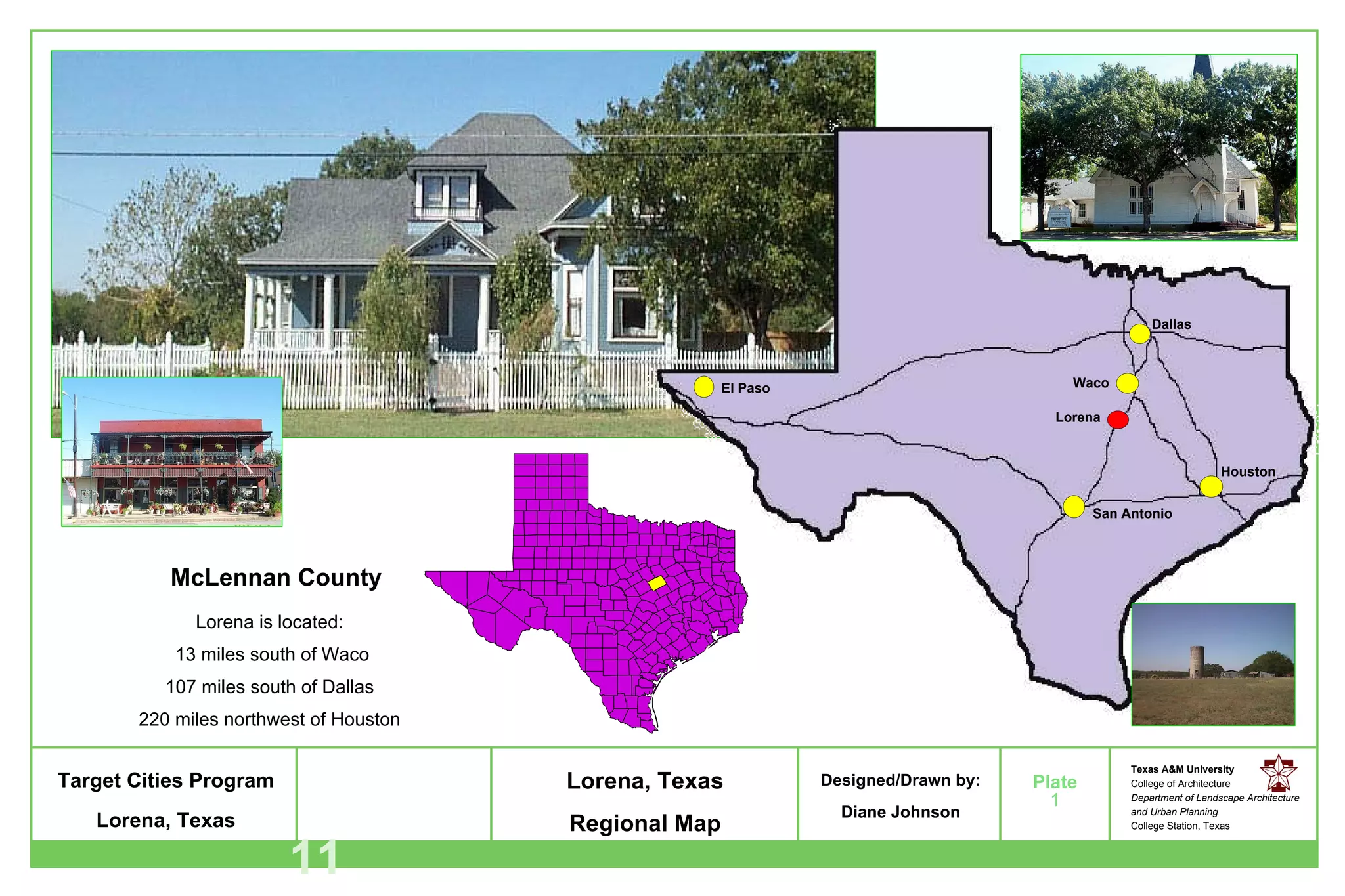
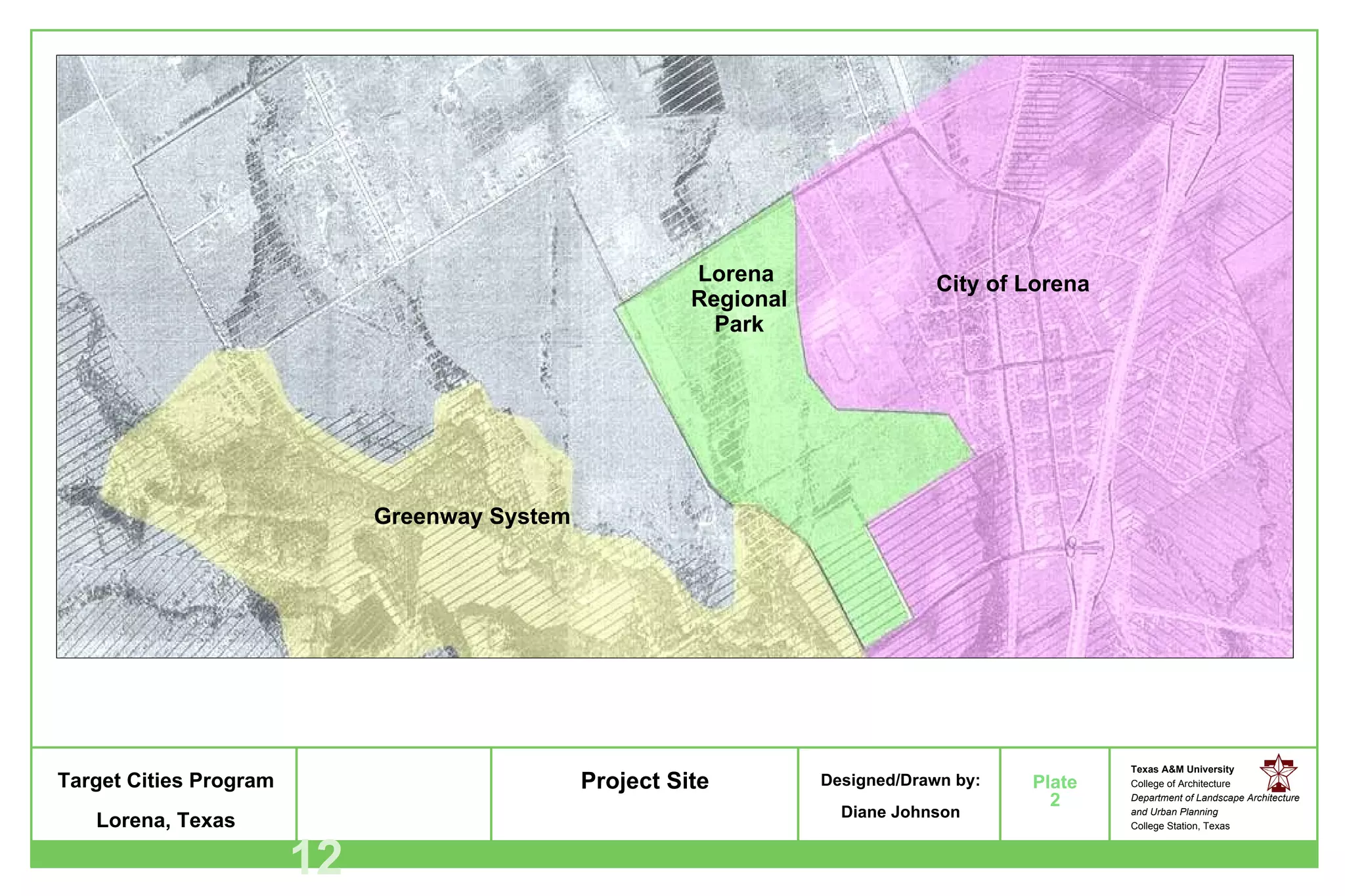
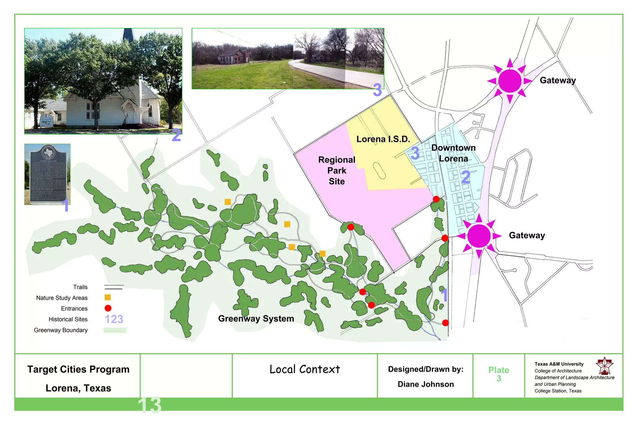
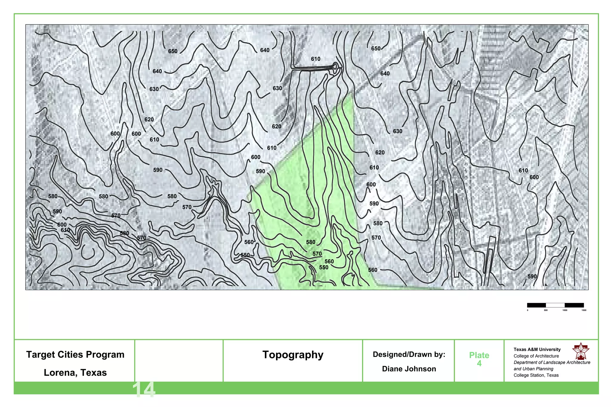
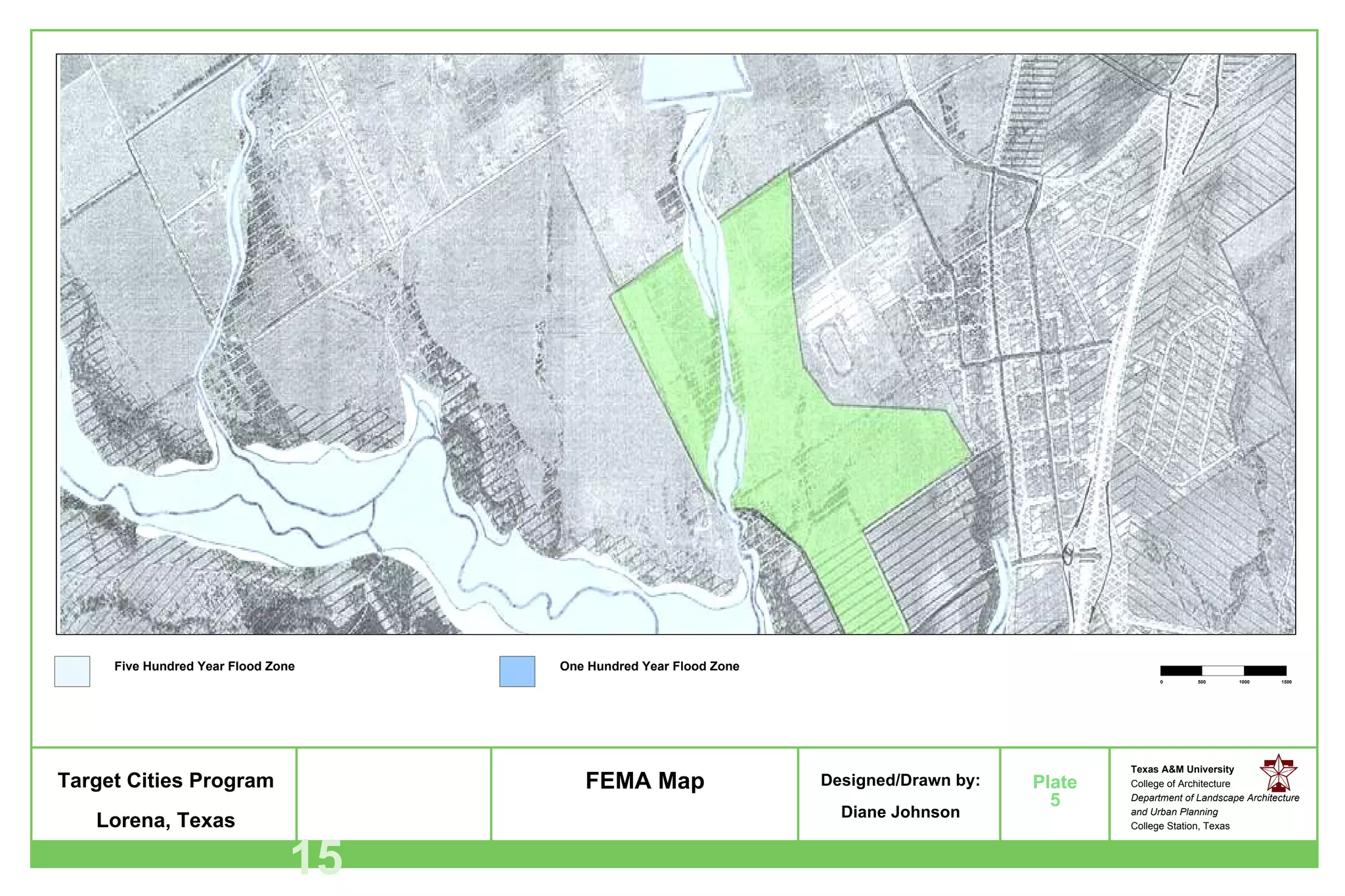
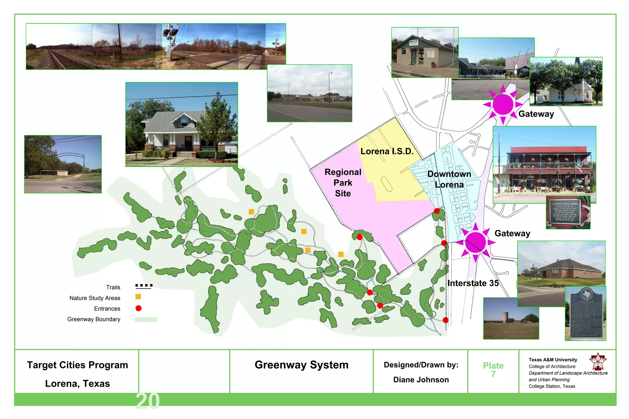
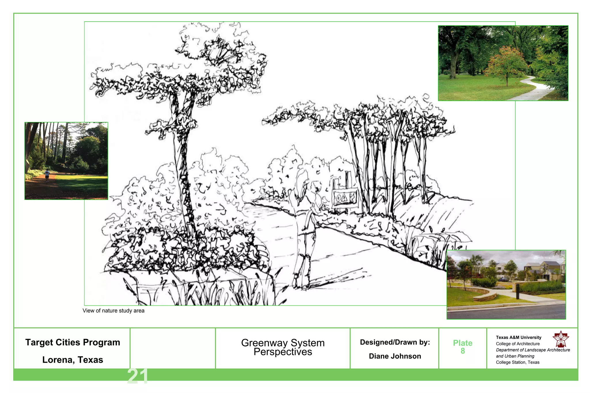
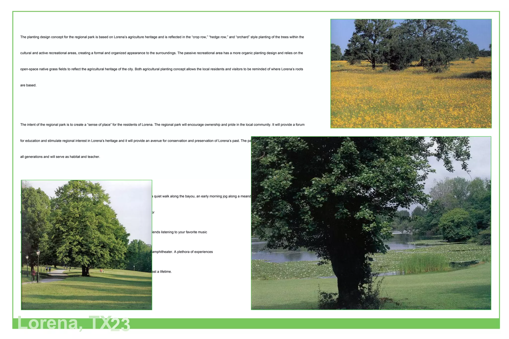
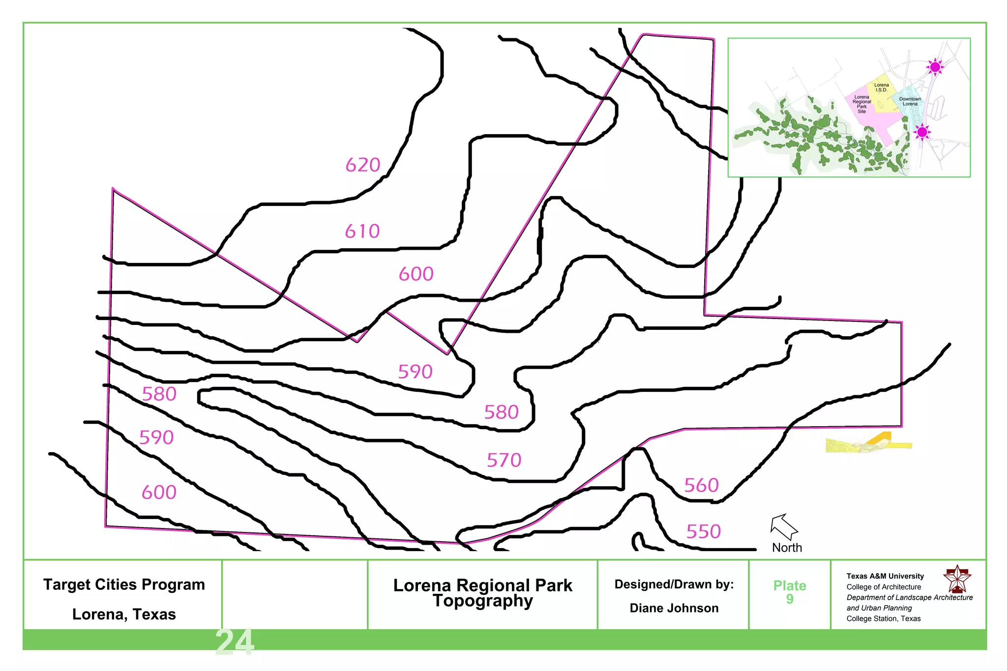
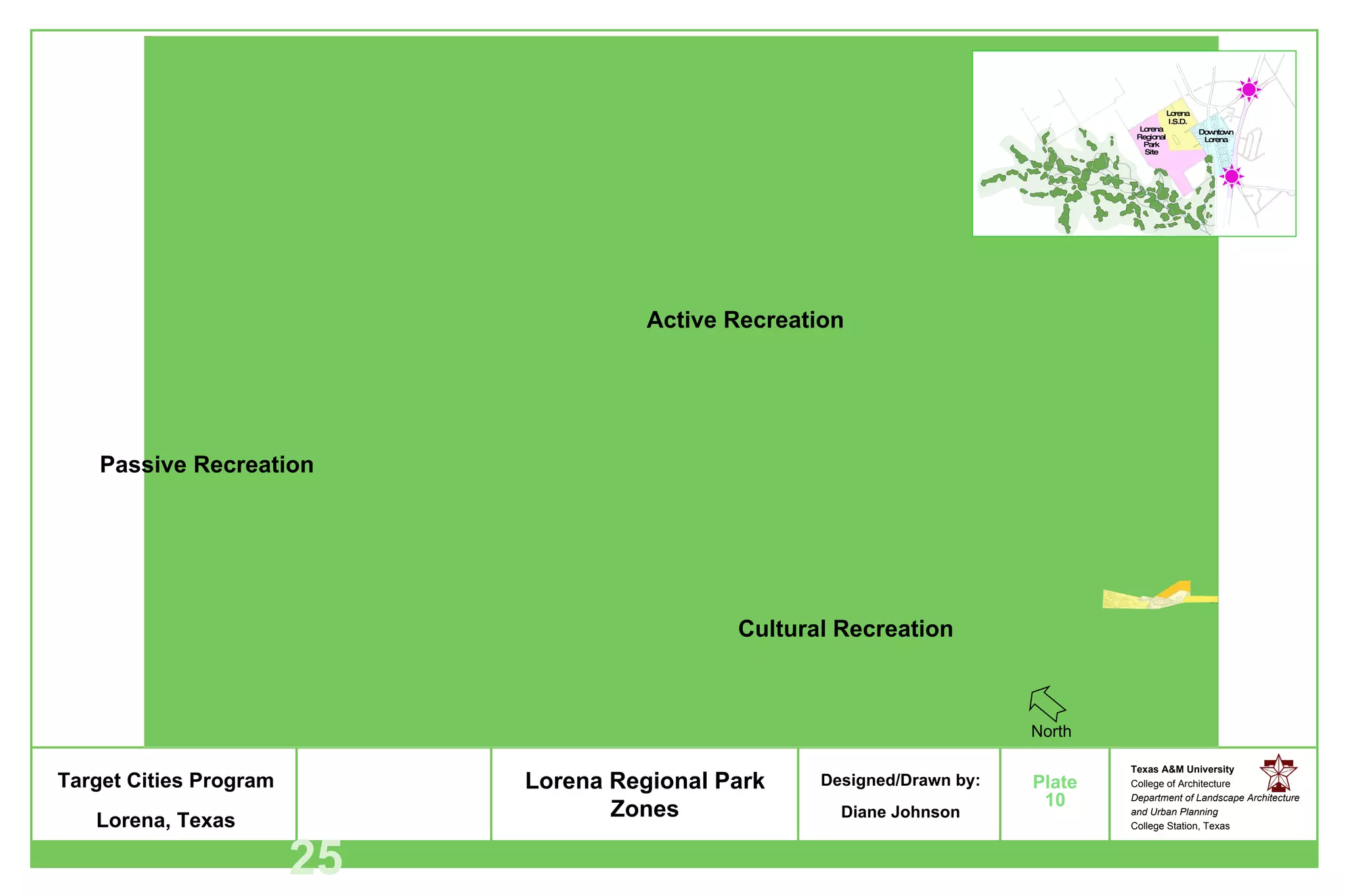
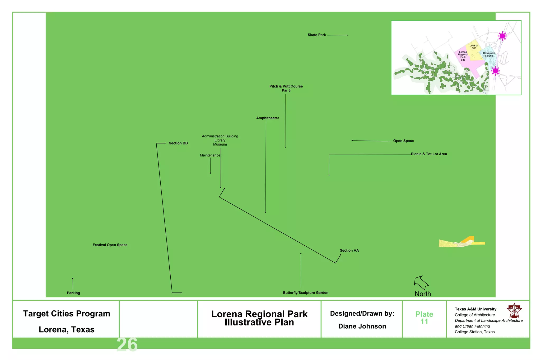
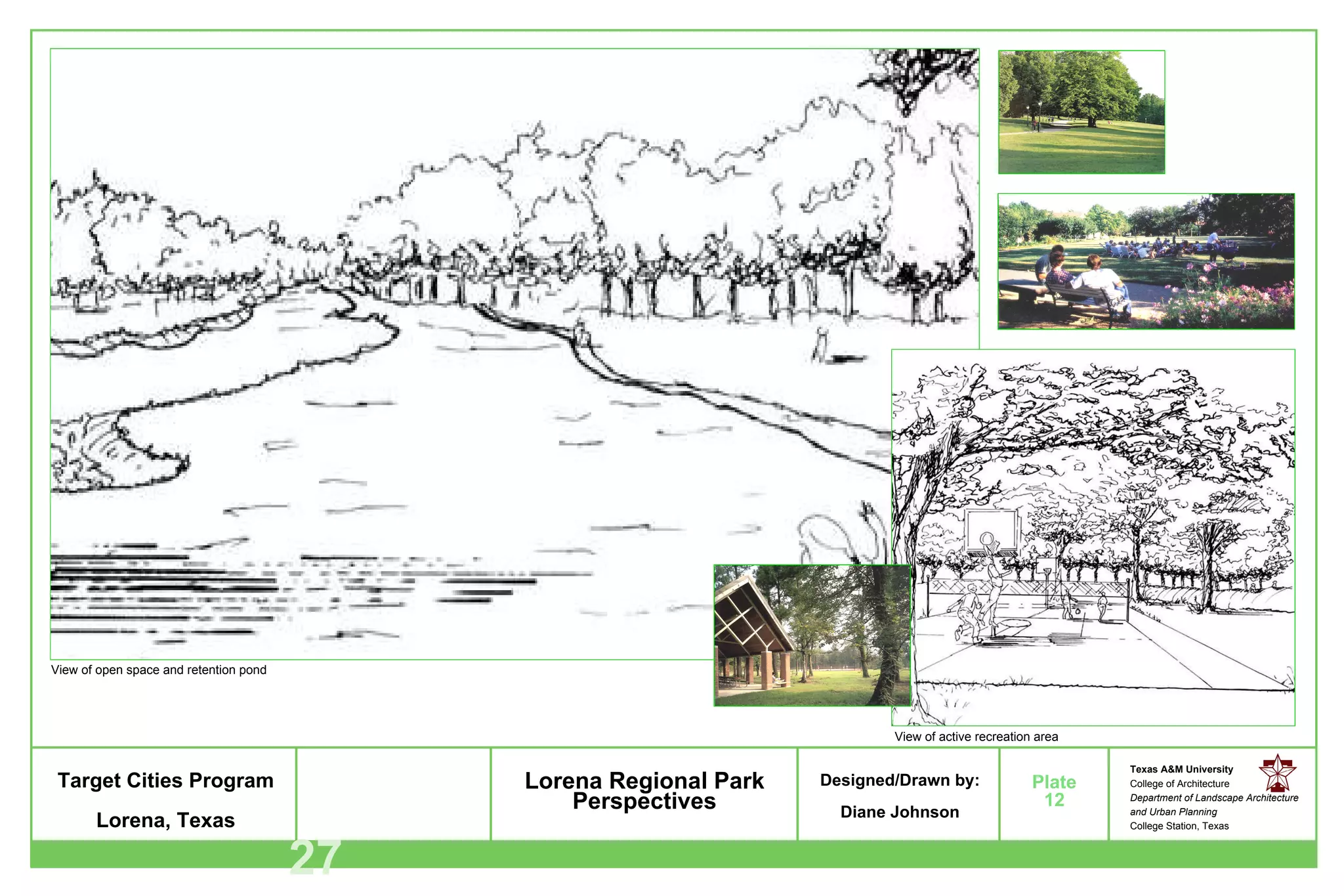
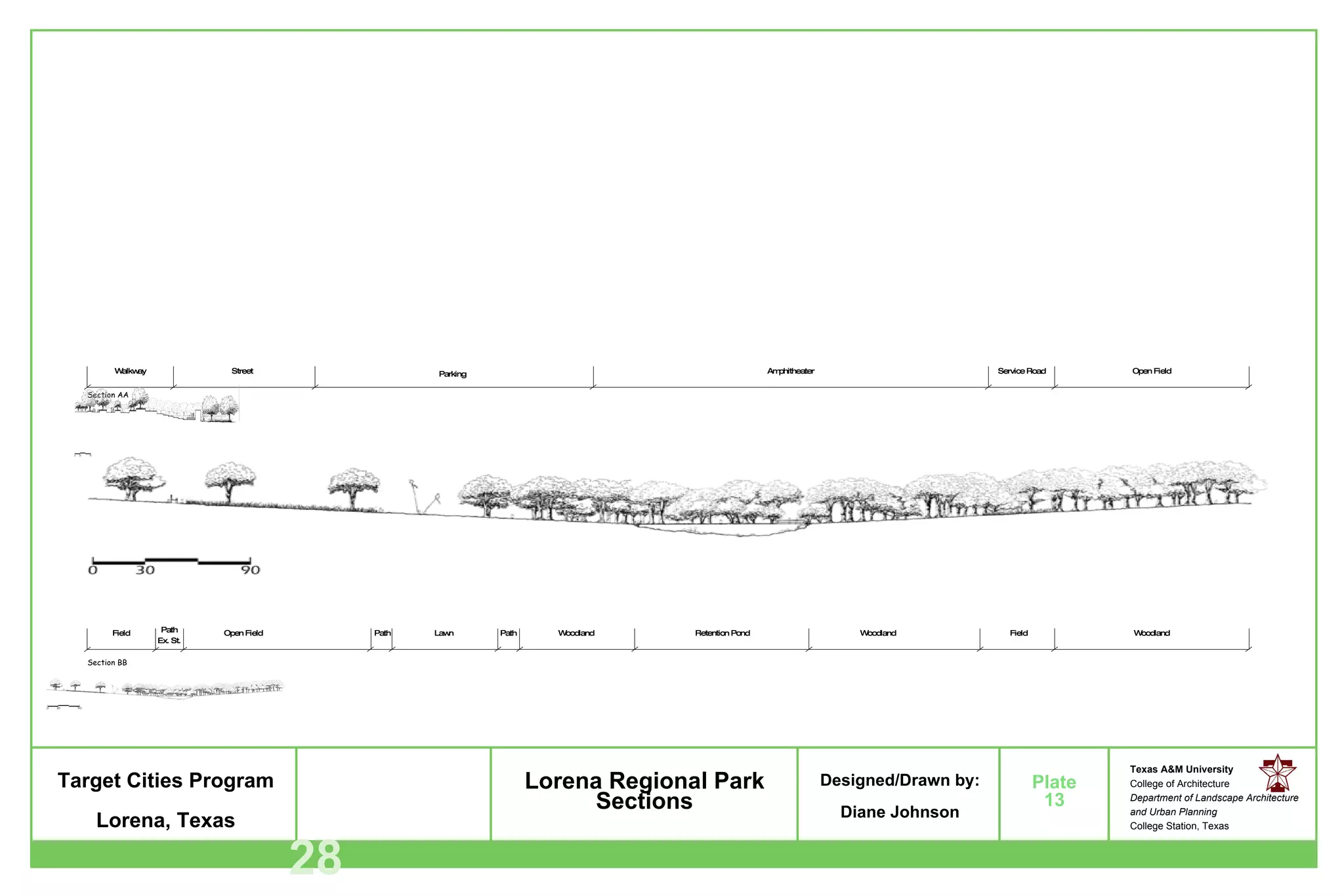
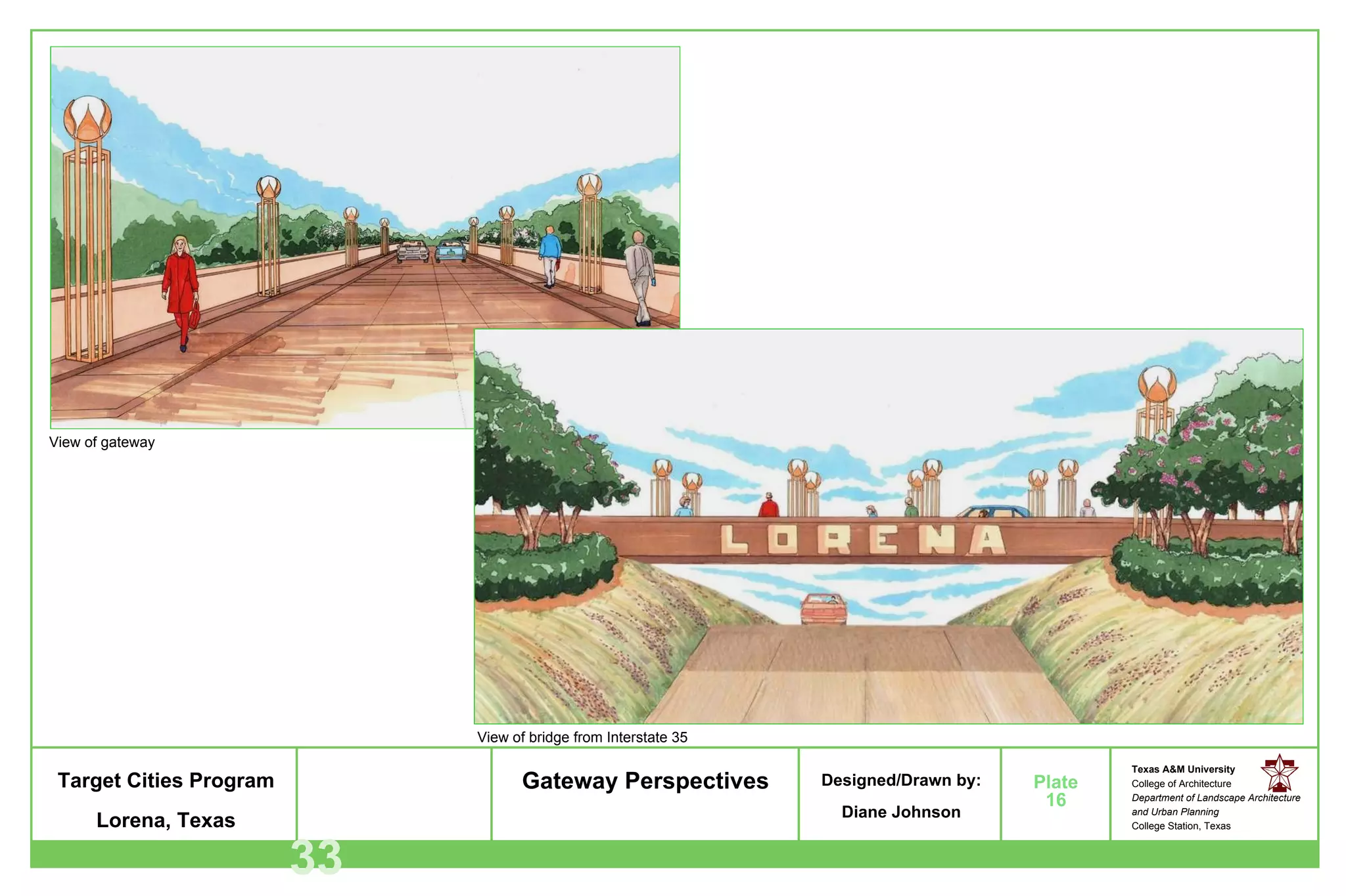
The document provides details about a master plan project for the City of Lorena, Texas. The plan includes developing a greenway system along a riparian zone, creating a 187-acre regional park, and designing gateways for two highway exits. The project aims to preserve Lorena's natural environment and heritage while promoting controlled economic and population growth. The greenway and park will provide recreation opportunities and connect different areas of the city.
This Watershed Management Plan is the result of extensive input from community members. Further comment is always appreciated, and is necessary for the continued success of the Stratford Area Watershed Improvement Group. Please forward your comments to:
Kelley Arnold, Watershed Coordinator
367.3605 (w)
stratfordwater@gmail.com
Thank you for your support
The Morris County Planning Board held its regular monthly meeting on December 4, 2014. Key discussions and actions included:
- Approval of prior meeting minutes and acceptance of financial and development reports.
- Discussion of development applications and subdivision plans, including concerns about potential impacts to historic remains from a proposed development.
- Reports from committees on environment, land use, legislation and municipal matters, long range planning, and liaisons.
- Presentations on housing trends in Morris County and an upcoming process to evaluate the Highlands Regional Master Plan.
- Scheduling the January meeting to include the Board of Transportation to discuss an updated Circulation Plan Element.
NewtonIQ will be an enterprise cloud software for marketing, sales, and support. It will include an online marketplace (SmartMarket) and add-on applications (IQapps). This document outlines 16 potential IQapp projects that could be developed on the NewtonIQ platform, including projects to create a SmartMarket, integrate auto-dialing systems, build customized reporting dashboards, and develop applications for medical practices, payroll, email marketing, faxing, chat, and point-of-sale. Developers would gain experience building cloud-based applications using NewtonIQ's framework and SDK.
AIR - Framework ( Cairngorm and Parsley )senthil0809
Adobe AIR is a runtime environment that allows developers to create rich internet applications that can run as desktop applications. It combines HTML, AJAX, Flash, and Flex technologies to build applications that have access to native desktop capabilities and features like file I/O, menus, notifications, and more. The document discusses what AIR is, its APIs and features, how to create and export AIR applications, and provides overviews of the AIR development workflow and frameworks like Cairngorm, PureMVC, and Parsley that can be used for AIR application architecture.
IPOboard is Russia's first private equity and venture capital exchange connected to MICEX, the country's largest stock exchange. It allows small and medium businesses to raise capital from investors by facilitating the sale of private company shares. IPOboard provides easier access to financing for entrepreneurs and a way for venture capitalists to generate returns from investments. Target clients include new, growing companies seeking institutional investors and those with IPO ambitions. Basic requirements for listing include demonstrated market potential, a professional team, and at least 10% of shares available for sale.
The document discusses the Owner's Project Requirements (OPR) process, which the University of Texas System has adopted as a best practice. The OPR documents a project's needs, functional requirements, goals, and performance criteria. It provides details to guide the project team and acts as a reference throughout the project. Developing a thorough OPR involves identifying stakeholders, resolving scope issues, and establishing institutional standards. The process requires inclusive workshops to document what, why, and how questions over multiple sessions. Revisions should be minimal and require a formal approval process. The OPR aims to improve overall project definition and management of cost, schedule, and other constraints.
This talk is a "how I did it" talk about how I took an idea, a web cam, Python, Django, and the Python Imaging Library and created art, explored science, and illustrated concepts that our ancestors knew by watching the sky but we have lost.
Este documento describe un trabajo práctico sobre la Edad Media que incluye la creación de una lámina compositiva con información sobre el cristianismo primitivo y bizantino en Occidente y Oriente, así como sobre el periodo románico y gótico, utilizando técnicas como collage e imágenes en 3D. El trabajo también requiere incluir detalles sobre el nombre del alumno, interiores, mobiliario, gráfica e indumentaria de dichas épocas.
The document discusses the 90/10 principle, which states that 10% of life is made up of external events outside our control, while 90% is determined by our reactions to those events. It provides an example of how reacting negatively to a spilled cup of coffee can ruin the whole day, while responding positively avoids stress and conflict. The key message is that while we cannot control what happens, we can control how we respond, which significantly impacts our experiences. Applying the 90/10 principle by not letting negative external events affect us can result in a more positive and stress-free life.
Netflix is the world's largest online movie rental service with over 10 million subscribers. Their mission is to connect people with movies they'll love. They stream over 12,000 movies instantly and ship over 100,000 DVD titles from over 50 distribution centers. Netflix is moving to AWS to gain the benefits of elastic infrastructure, massive scale, and mature application services which will help them better stream movies, improve availability of key services, and simplify operations.
UI development involves understanding containers and layouts. Containers can hold other containers or controls. Flex offers various container types including Canvas, Panel, TitleWindow, HBox and VBox. Layout containers control sizing and positioning of child components. Common layouts include vertical, horizontal and absolute. Lists display data using items and support features like custom item renderers, selection, and paging. ViewStack allows displaying different pages. States change an object's condition, like minimal vs detailed phone displays.
The document discusses genetic algorithms and genetic programming in Python. It describes how genetic algorithms are inspired by natural selection and genetics, using techniques like selection, crossover, and mutation to evolve solutions to problems. It provides examples of using the Python library PyEvolve to implement genetic algorithms and genetic programming to solve problems like minimizing test functions and forecasting temperatures.
This document discusses Hadoop Distributed File System (HDFS) and MapReduce. It begins by explaining HDFS architecture, including the NameNode and DataNodes. It then discusses how HDFS is used to store large files reliably across commodity hardware. The document also provides steps to install Hadoop in single node cluster and describes core Hadoop services like JobTracker and TaskTracker. It concludes by discussing HDFS commands and a quiz about Hadoop components.
This document discusses multi-touch development in Flash and Flex. It covers supported platforms and hardware, touch events versus gestures, the API for handling user interaction, new Flex touch and gesture events, and provides a code example.
Big data - Apache Hadoop for Beginner'ssenthil0809
The document provides an introduction to building big data analytics with Apache Hadoop for beginners. It outlines the roadmap, targeted audience, and definitions of big data and Hadoop. It describes sources of big data, characteristics of volume, velocity, variety and veracity. It also gives examples of structured, semi-structured and unstructured data sources. Finally, it compares traditional and big data analytics approaches and provides a quiz on Hadoop concepts.
소셜,모바일, 영상 중심의 1인미디어
YouTube 글로벌 생태계 이해 ( Contents Creator - Advertiser - User )
넥스트 YouTube 경쟁 심화, YouTube vs. Facebook 동영상 비교
동영상마케팅을 어려워 하는 이유?
트리플미디어 기반 마케팅 실행 방안 수립 ( Zappos, Joyus, Vat19 등 )
고객 참여형 영상 콘텐츠 마케팅 중요성 ( 유한킴벌리 사례 )
마이크로 스토리보드 활용 방안 (모바일 환경을 고려한 영상 콘텐츠 Creative 기획)
YouTube카드 등 인터랙티브 플레이어 사례
네이티브 동영상광고 및 동영상 검색엔진 최적화 (Video SEO) 방안
Metro’s portfolio of outdoor destinations and nature programs has grown dramatically during the past two decades, laying the groundwork for a world-class regional park system.
To realize that opportunity, Metro has developed a system plan that will guide future decision-making and investments for regional parks, trails, natural areas and nature programs. Community members and partners helped shape a plan that lays out Metro's mission, role and priorities going forward – and introduces the 17,000 acres of parks, trails and natural areas that Metro manages on behalf of the public.
The document is a grant proposal from the Historic Hudson Community Association (HHCA) seeking $105,883 from the Licking County Foundation to redevelop the North Street Park in Newark, Ohio. The HHCA aims to transform the neglected park into a safe, professionally-designed space for children to play, community gatherings, and group activities. The multi-year redevelopment project would improve accessibility, add a playground, shelter, and landscaping. Completing the project would boost quality of life and socioeconomic development in the surrounding Historic Hudson neighborhood.
This document provides a transportation assessment and best practices guide for the Town of Lansing, New York. It summarizes the baseline transportation conditions in the town, including traffic volumes, congestion hotspots, safety issues, and perceptions of residents. Major roads like Route 34, Triphammer Road, and Warren Road experience high traffic volumes. Areas of congestion include Route 34B near the town center and a segment of Warren Road. Safety is a concern, with high crash rate intersections located along Route 34 and Triphammer Road. The document identifies transportation issues and makes 3 recommendations: 1) expanded design guidelines for new developments, 2) a transit-oriented development overlay zone, and 3) an adequate public facilities ordinance to moderate development
Document 2009 la finca del sur / sbufcAresh Javadi
The South Bronx Urban Farmer Collaborative (SBUFC) is seeking volunteers to help develop an urban farm at 138th Street and Grand Concourse in the Bronx. The farm will be open Fridays from 5pm to sunset and Saturdays and Sundays from 1pm to sunset. SBUFC is a group of community gardeners and farmers committed to creating a productive urban farm to serve the local community and provide fresh produce, education, and community space. The document provides details on ownership of the land parcels, the vision and goals for the farm, plans for its development, and the history and accomplishments of SBUFC to date.
The South Bronx Urban Farmer Collaborative (SBUFC) is seeking volunteers to help develop an urban farm at 138th Street and Grand Concourse in the Bronx. The farm will be operated by a collaborative of community gardeners and farmers and supported by local non-profits and organizations. Volunteers are needed on Fridays from 5pm to sunset, and Saturdays and Sundays from 1pm to sunset, to help with tasks like moving wood chips and compost, planting flowers and herbs, and starting seeds. The goal is to create an abundant and productive urban farm to provide fresh local produce and agriculture education to the surrounding community.
The document summarizes a project to design Hunters Point South Waterfront Park and infrastructure in Queens, New York. The author served as the overall design lead, coordinating the design team and securing public approvals. The project aimed to create an innovative, sustainable waterfront park and neighborhood that could serve as a model for future city projects. It featured designs for the park, streets, and green infrastructure systems to balance new housing development while connecting residents to the waterfront.
The document provides a management plan for Wright Park in Middlebury, VT. It includes details on the park's location within Addison County and the town of Middlebury. The plan summarizes the park's history of land use and current recreational uses. It also analyzes the park's environmental features, including topography, water resources, soils, natural communities, and avian wildlife. The document outlines community goals for the park through public engagement and reviews recommendations to balance conservation and recreation based on an assessment of constraints and opportunities.
This document presents the National Park Service's Urban Agenda. It aims to make the NPS more relevant to urban Americans by strategically organizing its many urban parks and programs. The agenda recommends unprecedented coordination of parks, programs, and partners to connect with where most Americans live in cities. It also seeks to strengthen the relationship between urban populations and more remote national parks. Success requires focusing efforts, improving communication, and setting shared objectives between NPS units and partners.
Multiple Benefits: Regional Visioning to Local EngagementPark Pride
The document presents the Emerald Necklace Expanded Vision Plan, which aims to create an interconnected network of parks, greenways, and open spaces across Los Angeles County. The plan seeks to realize the original vision of the Emerald Necklace by protecting natural areas, restoring habitats, and connecting communities through green infrastructure. It identifies opportunities to implement regional goals like improving public health, access to nature, water management, and climate resilience through local projects along river corridors and in underserved areas from the mountains to the coast. The vision is to realize an aspirational green network across the entire county through collaborative regional planning and local implementation efforts.
The document discusses two charrette sites in Blacksburg, Virginia that were the focus of an "Xtreme LA" event hosted by Virginia Tech. For the former middle school site (called "Middle Hill"), the team proposed mixed-use and mixed-density housing, connected open spaces, and pedestrian-friendly streets to create a diverse, connected new neighborhood. For the second site ("The Cradle") between a forest and trail, the team proposed preserving ecology, increasing connectivity and green space, and higher density housing while protecting natural areas. The charrette brought together professionals and students to develop creative planning solutions for managing growth in Blacksburg through sustainable development.
This document provides background information and defines a proposed green infrastructure project for San Jose, CA. It begins with an introduction to the project team and their interests. Section 3 discusses the historical context of San Jose's stormwater issues and presents a "mess map" to illustrate the complex problem. Section 4 defines the goals of the proposed project as reducing critical pollutant loads to maintain water quality standards. It identifies the key pollutants in San Jose and discusses how green infrastructure can mitigate them. The document concludes by comparing and selecting high-impact green infrastructure design proposals to address in the next phase.
Here are the key demographics of the local counties:
- The population ranges from 15,226 (Sibley County) to 65,091 (Blue Earth County)
- The counties are predominantly white (92.8-95.5%)
- Median incomes range from $48,911 to $58,074
- High school diploma rates are 86.9-93.1%
So in summary, the local population is predominantly white, with median incomes around $50,000-$60,000 and over 90% having a high school diploma. This data helps understand the demographic makeup of those most likely to use and benefit from Lake Washington County Park.
A REVIEW ON CRITERIA FOR GREEN INFRASTRUCTURE TO BE ADOPTED BY LOCAL AUTHORITIESRichard Hogue
This document reviews criteria for green infrastructure that could be adopted by local authorities in Malaysia. It begins with an abstract discussing how green infrastructure planning has grown since the late 1990s as a way to preserve green spaces and their recreational/social benefits. The document then provides background on urbanization issues, defines green infrastructure, and discusses how the approach is still developing in Malaysia. It reviews the history of green infrastructure development, including efforts in the UK, US, and Malaysia. The purpose is to identify criteria for local authorities in Malaysia to effectively control development through green infrastructure.
The League of United Latin American Citizens (LULAC) files a formal complaint regarding a highway project in Kings Beach, California. LULAC argues that reducing highway lanes from four to two will significantly increase traffic and divert it through low-income Hispanic neighborhoods, negatively impacting the community. LULAC believes the project's environmental review was inadequate and did not properly address community concerns, environmental justice, or civil rights issues. LULAC requests that the Federal Highway Administration review the status of the project to ensure it complies with regulatory requirements.
LULAC Civil Rights Complaints at TahoeJerry Dinzes
North Lake Tahoe LULAC worked with the California LULAC board on a series of complaints that helped to keep the Kings Beach area safe from traffic hazards and environmental degradation. These complaints pertain to two major infrastructure projects: 1) A wood burning biomass plant that Placer County voted to build in Kings Beach. The power plant was in close proximity to residential homes and an elementary school. The plant impeded on the beautiful viewshed of the Tahoe Basin. After a contentious battle, Placer County agreed to build the biomass plant outside of the Tahoe Basin, at a landfill site. 2) The Kings Beach Commercial Core Improvement Project will divert significant traffic through residential neighborhoods in the years to come. LULAC fought to stop residential cut through traffic. After a contentious battle, Placer County agreed to commit nearly $2 million to a neighborhood traffic management plan. This money was invested in speed humps and sidewalk development.
Complaints filed by North Tahoe LULAC were written and submitted by Jerry Dinzes, (BTW: These complaints were written prior to any formal university education. Just saying, I've come a long way.) Complaints submitted by Cal LULAC were originally drafted by Jerry Dinzes and Dave McClure. Cal LULAC's executive board made final revisions and submitted.
From The Municipal Art Society of New York, advocating for smart urban design, planning, and preservation through education and initiatives.
This report is a synthesis of the ideas generated from a day-long design charrette in June 2011, and represents the community’s vision for a new waterfront open space. MAS released the report to the NYC Economic Development Corporation (EDC) and their consultant for the project, AECOM, with the intention of guiding the future transformation of the former Con Ed Pier into a new community park.
This is the turning point for waterfront access along the East Side of Midtown and is a continuation of MAS’ long standing commitment to bringing New Yorkers back to the waterfront and ensuring that the communities have a voice in shaping their future.
GIS 165 Tarzana Nature & Education Center Project Proposal FINAL (1)Paige Terry
The Tarzana Nature and Education Center Project Proposal details plans for a new park in Los Angeles, California. Key aspects of the proposal include selecting a suitable 2.3 acre parcel near the LA River that meets requirements. The proposal outlines stakeholders and designs for park sections including an education center, pond, community garden, greenhouse, playgrounds, and landscaping. It also includes schedules, budgets, and additional funding options to help offset costs of constructing and maintaining the new community park.
The Historic Millwork District in Dubuque, Iowa was once home to over 2,500 millworking jobs in the early 20th century but sat mostly vacant from the 1960s-1970s as industries closed. Through public-private partnerships and a master plan process, the city aimed to redevelop the 17 block, 1 million square foot district in a sustainable manner. Over $75 million has been secured from various public and private funding sources to transform the area with over 700 housing units, retail space, streets, and green space. Partnerships focused on infrastructure improvements through complete streets design and streetscape enhancements to reconnect the district to downtown and make it more bike and pedestrian friendly.
1. Texas Target Cities Program Master Plan For Greenway & Regional Park: LORENA, TX Prepared by Diane Owen-Johnson Department of Landscape Architecture and Urban Planning Texas A&M University May 2002 Prepared by Diane Owen-Johnson Department of Landscape Architecture and Urban Planning Texas A&M University
2. Lorena, Texas is a peaceful and quaint town. Located approximately 13 miles south of Waco, Texas, this bedroom community is working enthusiastically towards maintaining its heritage and natural environment by adopting a comprehensive master plan for the City of Lorena. Originally settled in 1881 as a station on the Missouri-Kansas Texas Railroad, Lorena has managed to maintain its charm and simplicity for over a century. The City of Lorena has adopted a comprehensive master plan that will assure consistency in economic and population growth. The plan will also maintain the historical sites, cultural heritage, and preserve natural and undeveloped land within the city. Another exciting aspect of the master plan is an alternate transportation route in the form of a Greenway System (pedestrian / bikeway). The Greenway System will provide multiple benefits to the community such as recreation, education, and connectivity throughout the city. Another aspect of the comprehensive plan is to create a 187 acre regional park for the local and surrounding communities. The purpose of this project is to develop a schematic design for the Greenway System, a concept design for the Lorena Regional Park, and a Gateway design for both the north and south Interstate 35 exits. This project is part of the Texas Target Cities Program, a program that has been in effect since 1993. The Texas Target Cities Program is set up as a coordinated effort between a city, with a population of less than 10,000 and A&M’s second year graduate planning students. Abstract Acknowledgement Lorena, TX I would like to express my appreciation to all of the people who have offered their expertise, time, talent and encouragement throughout this project. I would like to especially thank Dr. Chang-Shan Huang for having faith in me and in being an inspiration to me through his exceptional artistic vision and talents. I would also like to thank Dr. David Pugh and Dr. Scot Shafer for their expertise, direction and time. And, I would like to thank the City of Lorena, Texas for allowing A&M to participate in the planning of their future. 1
3. Lorena, TX 2 Table of Contents Abstract 1 Acknowledgement 1 Table of Contents 2 List of Figures 3 I. Introduction 4 1.1 Project Background and Procedure 4 1.2 Design Approach 5 1.3 Design Process 5 II. Literature Review 6 2.1 Greenway 6 2.2 Parks 7 III. Site Analysis 8 3.1 Region Context 8 3.2 Demography 8 3.3 Land Use 8 3.4 Typography 9 3.5 Flood Plain 9 3.6 Soil Analysis 10 IV. Design Program 17 4.1 Design Goals and Objectives 17 4.2 Regional Park 18 V. Design Concept 19 5.1 Gateway System 19 5.2 Regional Park 22 5.3 Gateway Improvement 31 VI. Discussion 34 VII. Bibliography 35
4. Lorena, TX 3 List of Figures Plate #1 Lorena, Texas Regional Map 11 Plate #2 Project Site 12 Plate #3 Local Context 13 Plate #4 Typography 14 Plate #5 FEMA Map 15 Plate #6 Soil Map 16 Plate #7 Greenway System 20 Plate #8 Greenway System Perspectives 21 Plate #9 Lorena Regional Park Topography 24 Plate #10 Lorena Regional Park Zones 25 Plate #11 Lorena Regional Park Illustrative Plan 26 Plate #12 Lorena Regional Park Perspectives 27 Plate #13 Lorena Regional Park Sections 28 Plate #14 Lorena Regional Park Phasing Plan 30 Plate #15 Gateway Zone 32 Plate #16 Gateway Perspectives 33
5. 1. 1 Project Background and Procedure The City of Lorena, Texas, located in McLennan County, was settled as a station on the Missouri-Kansas and Texas Railroad in 1881. Over the past one hundred years, Lorena’s population has grown to approximately 1244 residents and eighty-two businesses. The city limits is split by the north-south 1-35 corridor and the Union Pacific rail line. Located thirteen miles south of Waco, Texas and 21 miles north of Temple, Texas, Lorena is considered to be a bedroom community with 82% of Lorena’s residents working outside the city limits. The proposed Lorena Greenway System, Regional Park, and Gateway are essential in providing the recreation space and identity for Lorena,Texas and is a major part of the overall comprehensive master plan for the city. Lorena would like to protect the quality of life that now exists within its community by taking ownership of specific valuable natural environments and developing the areas into recreational and educational outdoor spaces for both the local and adjacent communities. The area chosen for the Greenway System is a mature riparian zone along Cow Bayou. The property that has been selected for the Lorena Regional Park is a 187 acre contiguous parcel of land located adjacent to the Lorena I.S.D. school complex, west of Ten Oaks Plantation, south of Williams and north of Hatch Road. I. Introduction Lorena, TX 4 Tom C. Winn Larry Ditto Jeffrey G. Schultz
6. 1. 2 Design Approach Economic viability is key to Lorena’s growth and sustainability. It is Lorena’s hope, through the development of the comprehensive master plan, to mitigate “sprawl,” preserve the quality of life, and to save open space and natural riparian zones, to be utilized as future outdoor recreational amenities for the entire community. In keeping with the desires of the City of Lorena and the community at-large, the design approach taken for the new Greenway System and Lorena Regional Park is one of stewardship, economic stimulation, and connectivity. The focus of the new City Regional Park is to facilitate and stimulate community association through enjoyable passive and active outdoor recreation, education, cultural events and festivals. There is a direct correlation between preserving and maintaining natural environments and creating economic stimulation through community development where natural environments are kept as outdoor recreational space for the community. The new Regional Park will be large enough and diverse enough to facilitate the projected population and housing growth. The new park promises to become a focal point in the city and an economic based attraction to the surrounding areas through tournament sponsorships. In conjunction with the park, the expansive Greenway System will be an added attraction for the involvement of the surrounding communities in “connecting up” to the Greenway System and “buying into” the local commerce while actively participating in recreation and choosing an alternate means of transportation, thereby saving fuel and building good health in the individual and further providing a visible stewardship approach to the environment. There is a system to the design process. In this system, a number of steps are taken. These steps are necessary to gain as much insight as possible of a project to realize the inherent constraints and possible solutions. a. Literature Review The first step in the process is a literature review. In this information gathering step, past and current publications are read and analyzed for the specific purposes of ascertaining possible solutions and/or potential problems relevant to the the project that is to be designed. b. Data Collection Pertinent data was collected through personal interviews with residents, historians and governing entities within Lorena as was questionnaires, site analysis and photographs. c. Site Inventory and Analysis Specific physical information was gathered and examined to facilitate and develop a concept plan. The site inventory included circulation patterns, regional and local maps, zoning maps, soil maps, drainage maps, floodplain maps, transportation maps, existing land use maps, annexation maps, and land ownership maps. Historical sites were also noted. The purpose for selecting this parcel of land for Lorena’s Regional Park is because of its proximity to the I.S.D. complex. Within the I.S.D. complex are Lorena’s Elementary, Middle and High Schools. Further, the comprehensive master plan calls for single-family development immediately north and a mixed use Creekside District to the south and west. The new Lorena Regional Park will be a major node within the Greenway System being proposed and its connectivity to Lorena’s downtown area and other significant historical and entertainment sites within the community will enhance the community’s outdoor recreational experiences and provide a place to host major regional events lending to the economic growth of the city. Lorena, TX 5 1. 3 Design Process Larry Ditto John L. Tveten
7. 2.1 GREENWAYS - Why a Greenway System and Regional Park? The earth is important because it supports life. Throughout history, man has relied on the natural environment for food, shelter, water and the air we breathe. Over many decades degradation occurred to vast expanses of the natural environment through man’s progress and activities. Since the beginning of the 20 th century, the Bureau of Mines, under the department of Interior, created an Office of Air Pollution to control smog emissions. In 1955, the government decided that smog was a big enough problem to establish the Air pollution Control Act of 1955, which was the first in a series of clean air quality control acts, which are still in effect and continue to be revised and amended (Flemming, James R. and Knorr, Bethany R. 1993). In April, 1970, “Earth Day” was observed internationally to emphasize the necessity for the conservation of the worlds natural resources. The emphasis is on solutions that will slow and possibly reverse the negative effects of human activities. In 1972, Congress enacted the first comprehensive national clean water legislation in response to growing public concerns for serious and widespread water pollution. The Clean Water Act is the primary federal law that protects our nation’s waters, including lakes, rivers, aquifers and coastal areas. The Clean Water Act’s primary objective is to restore and maintain the integrity of the nation’s waters. The act translates into two fundamental national goods: eliminate the discharge of pollutants into the nation’s waters and achieve water quality levels that are fishable and swimmable (EPA 2001). All that is needed to provide a healthy, prosperous future for our planet and it’s people, is for all to act as Trustees of Earth, to do those things that will nurture and improve Earth’s migrating wildlife in their seasonal travels: from revitalized urban waterfronts to tree shaded footpaths along a stream, far from the city. Greenways provide a means to save precious ecosystems and provide outdoor recreation. Because the realm of possibility seems endless, to define the word greenway would indeed limit the vision. Greenways then become only what we have said they can be, and then the flexibility that ensures us political and public acceptance for each unique project is gone. On the contrary, the greenway idea is, and should remain elastic (Scharz, Loring LaB 1993). Charles Little in his classic work “Greenways for America” has defined the greenway concept as follows: A greenway is a linear open space established along either a natural corridor such as a riverfront, stream valley, or ridgeline, or overland along a railroad right-of-way converted to recreational use, a landscaped course for pedestrian or bicycle passage. An open-space connector linking parks, natural reserves, cultural features, or historic sites with each other and with populated areas. Locally, certain strip or linear parks designated as parkway or greenbelt (Schwarz, Loring LaB 1993). d. Program Design It is at this step that a synthesis begins to take place of all of the previous steps in developing an initial schematic design for the project. This process allows opportunity to see circulation, and relationships within a design project and how the natural environment will be preserved or enhanced in the development of the design. e. Concept Design After the initial Program Design step, a Concept Design is developed which is a culmination of the information ascertained in the previous step. This step begins the final design development. f. Preliminary Master Plan After a concept design has been approved, a Preliminary Master Plan is developed showing the relationships and circulation of the design elements and features within the project site. g. Plan Refinement This step completes the design process development. Last minute changes are made at this step before detailed drawings are produced. h. Detailed Drawings Areas of interest will be delineated in perspective drawings and cross-section drawings. I. Final Design and Report All products of the project will be in CD-ROM format as well as a written report. Lorena, TX 6 Stephan Myers II. Literature Review
8. Unusual partnerships are forged for their protection. Synergism among groups that have traditionally competed with one another for use of the land may be a greenway’s most lauded characteristic. Most greenways support several uses and joint venture. A greenway project can preserve critical resources while encouraging dialogue among partners, setting common ground on which to focus further cooperation and coordination. Design trends and ecological research support the wisdom of open-space planning that compliments the shape and flow of the land. Landscape features, such as streams, rivers, ridge-tops and beaches are often linear. These natural features often provide the backbone for a greenway project or network (Schwarz, Loring LaB 1993). 2.2 PARKS - American parks or open-space developed as unconscious design expressions and were an outgrowth of utilitarian food production needs. Cemeteries represented early attempts at laying out functional and attractive outdoor spaces on a somewhat more grandiose scale. Early in the 19 th century the proliferation of country estates provided new opportunities for landscape designers. Sparking America’s urban park movement, Frederick Law Olmsted, known as the Father of Landscape Architecture, designed the first public green expanse of pasture we know today as the Boston Common. His contribution to the profession of Landscape Architecture and to the conservation and preservation of our nation’s beautiful outdoor recreational space is beyond words. Just a few of his most notable projects are: Parks - Central Park in New York, Prospect Park in Brooklyn, The Chicago South Park, Mount Royal in Montreal / Residential - Riverside in Illinois, Druid Hills in Atlanta / Academic Campuses – Stanford University, The College of California, Berkeley / Multiple memorials / U.S. Capital Grounds / Scenic Preservation – Yosemite Valley and Mariposa Big Tree Grove and Niagara Reservation / Biltmore Estate. The profession of Landscape Architecture came into its own in 1899 upon the founding of the American Society of Landscape Architects. Through the efforts of Frederick Law Olmsted’s son, FLO Junior formal instruction in landscape architecture began at Harvard the following year. After the Depression landscape architects found their way into leadership roles in public works, utilizing their array of skills in planning, site development, construction implementation and resource management. Their leadership and skill were demonstrated clearly in the development of a vast system of national forests as well as state and national parks that remain unparalleled anywhere in the world. Particularly important to our preservation and restoration of our open-space land came from Frederick Law Olmsted Sr. and his son in the roles they played in shaping America’s national park policy. It was Frederick Law Olmsted, with his typical futuristic outlook, planted the seeds for a visionary system of national parks in his work for the Commission on the Yosemite Valley in the 1860s. His son developed lifelong interest in conservation that resulted in a remarkable series of achievements advocating state and national park planning. It is Frederick Junior who is credited with the emphasis on a system of regional parks extending into the surrounding suburbs but, it was Frederick Law Olmsted Senior, who was concerned with how landscape could provide recreational and health benefits for the entire population. It was the step-brother of Frederick Law Olmsted Junior, John Charles Olmsted who began to change the emphasis from the pastoral to the more architectural and recreational. He urged controls over haphazard building to protect important vistas and areas of outstanding scenic beauty. Lorena, TX 7 The concept of historic preservation has grown beyond the confines of architecture to include the landscape itself. Now the preservation of comprehensive districts, neighborhoods, communities and entire rural landscapes has captured the attention of landscape architects, and our heritage is richer because of it. Similar in spirit and ethic to conserving historic landscapes has been the recent interest in restoring disturbed sites to their earlier natural character. Ugly quarries, strip-mined areas and other disfigured landscapes are being made productive and enjoyable again thanks to new revegetation concepts and other resource management techniques. One of the most noteworthy advancements of landscape architecture in recent times has occurred in large-scale landscape planning. Thanks to an infusion of ecological values and new technology, members of the profession assumed important roles in this vital land stewardship activity. A significant contribution to managing wild and rural landscapes has been the development of techniques for assessing and protecting scenic quality (American Landscape Architecture 1899). It is with this stewardship message in mind, that provokes my interest in Lorena’s conservation and preservation efforts. Without a system in place to recognize the aesthetic and economic value in the inherent beauty of a region, the beauty becomes lost in the development with grave consequences in the quality of life for the community. I am a proponent of the “Olmstedian” concept in having a “reverential” attitude toward nature. In my attempt to follow in the footsteps of FLO, I too, seek to create mystery, bounteousness and peacefulness as evoked by meadows with scattered shade trees or bodies of water that reflect the trees and sky.
9. Once Olmsted became a landscape architect, he had to formulate a new conception of his role; in the process he created a comprehensive body of theory about landscape design that was so original that few of his contemporaries grasped its full meaning. His emphasis on the psychological effects of scenery gave his design principles a firm base independent of the “battle of the styles.” Not aesthetic theory but the very health of the human organism became the touchstone of his art. The experience of scenery was visual, and as he developed his own concepts Olmsted wrote of the relations of sight to the wellbeing of the whole person. In one of his most concise statements he asserted that “A man’s eyes cannot be as much occupied as they are in large cities by artificial things…without a harmful effect, first on his mental and nervous system and ultimately on his entire constitutional organization.” Landscape provided a relief from the “rigidity and confinement and protrusion of art of the ordinary conditions of the city.” It was able “to refresh and delight the eye and through the eye, the mind and the spirit.” In describing the effects of scenery Olmsted used such terms as “sanative” and “restoring” and spoke of his parks as “sanitary institutions.” He insisted that in doing so he was not speaking metaphorically. He was sure that “the charm of natural scenery is an influence of the highest curative value; highest, if for no other reason, because it acts directly upon the highest functions of the system, and through them upon all below, tending, more than any single form of medication we can use, to establish sound minds in sound bodies.” Olmsted laid great stress on the restorative psychological effect of scenery. By the early 1850s he was describing it as something that occurred by an unconscious process. In Walks and Talks of an American Farmer in England he wrote, “Gradually and silently the charm comes over us, the beauty has entered our souls; we know not exactly when or how.” One could not directly pursue this feeling, he cautioned: “Dame Nature is a gentlewoman. No guide’s fee will obtain you her favor, no abrupt demand; hardly will she bear questioning, or direct, curious gazing at her beauty.” What Olmsted sought to promote, especially in his design of parks and other urban places, was what he called “unconscious or indirect recreation.” “Objects before which people are called to a halt, and to utter mental exclamation of surprise and admiration,: he taught, “are often adapted to interrupt and prevent, or interfere with the processes of indirect or unconscious recreation.” A corollary of this truth was that “the highest value of a park must be expected to lie in elements and qualities of scenery to which the mind of those benefiting by them is liable, at the time the benefit is received, to give little conscious cognition, and which, though not at all beyond study, are of too complex, subtle and spiritual a nature to be readily checked off, item by item, like a jeweler's or a florist’s wares.” In search of a fit analogy, he noted that “Landscape moves us in a manner more nearly analogous to the action of music than anything else.” At another time, in a similar vein, he wrote that “the chief end of a large park is an effect on the human organism by an action of what it presents to view, which action, like that of music, is of a kind that goes back of thought, and cannot be fully given the forms of words” (Beveridge and Rocheleau 1995). A great deal of criteria must be analyzed before a design project is successfully implemented. Site analysis is a method of examination that allows the designer to realize the buildout potential of a site and uncovers the problem areas or constraints on a particular site. Following are the typical criterion associated with developing a regional park such as the Lorena Regional Park and Greenway System. 3.1 Region Context The City of Lorena, Texas is located 13 miles south of Waco, Texas and 21 miles north of Temple, Texas. The city limits encompass 2.13 square miles and is to be substantially increased with the inception of the proposed comprehensive master plan. 3.2 Demography Demographically, Lorena is well-educated, young and Caucasian. The average age of Lorena residents is 30 years with approximately 36% of the population being 20 years of age. 3.3 Land Use The City of Lorena is in the process of adopting a comprehensive master plan to try and mitigate “suburban sprawl.” The proposed park and greenway system land is under public and private ownership. A 187 acre track of land adjacent to the Lorena I.S.D. and Ten Oaks Plantation is the proposed site for the new Lorena Regional Park. The Greenway System is land within the 100/500 year flood plain along Cow Bayou and is privately owned. The historical use of this land was crop land and open grass prairie. Currently the land is being utilized in the same way, although future development is, and will continue destroy this land if not protected through the conservation and preservation efforts outlined in the Comprehensive Master Plan being developed. III. Site Analysis Lorena, TX 8 3. 1 Regional Context 3. 2 Demography 3. 3 Land Use
10.
11. Lorena, TX 10 There are fourteen soil series (Stephen, Austin, Houston Black, Eddy, Sunev, Fairlie Lewisvile, Branyon, Frio, Dams, Mclennan, Ovan, Lott and Tinn) within the Lorena City Limits. The residential and commercial districts are located predominantly in the Stephen and partially in the Fairlie and Austin series. The native soils are primarily clay base. Clay base soils are conducive to extreme and immediate surface water runoff leading to flashfloods. Beyond the danger of being trapped within a flashflood, erosion of the vital topsoil occurs leading to a ground surface unsuitable for vegetation growth, habitat or mitigation of the deleterious effects of forceful and often toxic surface water runoff. Soil is one component which supports life on our planet. It holds the nutrients and water that nourish microscopic organisms within the soil structure which produce the base elements essential to plant and animal production and regeneration. Soil organisms are crucial to the chemical conversion and physical transfer of essential nutrients to higher plants. Fertile soil is a result of hundreds, if not thousands of processes working in a symbiotic relationship, I.e. the vertebrate animals foraging and leaving organic matter to be digested by the microscopic organisms within the soil which ultimately produces the nutrients absorbed through the root system for healthy plant growth. The nutrient cycle has to work in both directions for a healthy and sustainable environment to exist. Any change to an existing healthy eco-system by the infiltration of toxins, soil erosion or a change in the water cycle will disrupt and perhaps totally destroy a pristine and lush landscape that has reached equilibrium. At present, the land proposed for the recreational Greenway System is a mature riparian zone (Cow Bayou) including a 300 foot buffer zone on each side of the center line stream channel. Just outside this fertile zone are numerous agriculture crops and open 3. 6 Soil Analysis land with minimal vegetation. The existing land proposed for the Regional park is generally open land with minimal vegetation and a secondary riparian zone which feeds into Cow Bayou to the south and a few agriculture crops. Typical vegetation within the overall project site are indigenous to the Blackland Prairies: Pecan, Black hickory, Black Walnut, Sycamore, Burr oak, Eastern cottonwood, Post oak, Persimmon, Wax myrtle, Buckeye, Mexican plum, Sugarberry, Green ash, Flameleaf sumac, Green hawthorne, Black cherry, American elderberry, Bald cypress and Buttonbush. In summary, the proposed sites selected for the Greenway System and Regional Park have been specifically chosen in a effort to conserve as much of the natural environment as possible for preservation, recreation and aesthetic purposes. The location of the Greenway System and Regional Park have also been selected based on the Comprehensive Master Plan and the projected growth patterns and needs of the community. The Greenway System and Regional Park are centrally located to provide the connectivity and alternative transportation needs to the community’s many different points of interests. By acquiring and maintaining these natural environments as well as, reestablishing native vegetation to particular crop land, Lorena will have comfort in knowing that their community will be contributing to and protecting its natural heritage for future generations, while providing a means for outdoor recreation, education, health, and community association. Natural Prairie As Habitat View of A Typical Agriculture Fields
12. Lorena, Texas Regional Map Lorena is located: 13 miles south of Waco 107 miles south of Dallas 220 miles northwest of Houston McLennan County 1 11 Waco Lorena El Paso Houston Dallas San Antonio
13. Project Site City of Lorena Lorena Regional Park Greenway System 2 12
14. Local Context 1 3 2 3 Regional Park Site Lorena I.S.D. Downtown Lorena 1 2 3 Gateway Trails Nature Study Areas Entrances Historical Sites Greenway Boundary 123 Gateway 13 Greenway System
18. 4.1 Design Goals and Objectives The overall view of the Greenway System, Lorena Regional Park and Gateway is an effort to preserve, maintain and promote the natural environment and heritage of the local community. In recognizing the value of the natural environment, Lorena, in adopting a Comprehensive Community Master Plan, is making great strides in creating a “sense of place” for generations to come. Following is a list of goals and objectives to help clarify the intent of the proposed Greenway System, Lorena Regional Park, and Gateway. Greenway / Goal: Preserve and maintain the natural environment for the local community. Objective: Annex a significant portion of the healthy natural environment, specifically along the riparian zones to preserve and maintain habitat for the natural beauty, education opportunity and recreational activities. By preserving this sensitive eco- system, Lorena will be actively promoting an overall healthy and aesthetically pleasing community which will reflect the community’s sensitivity in preserving their local heritage. Goal: Establish connectivity for animal migration, habitat, and community mobility. Objective: Habitat connectivity is paramount in sustaining a healthy eco-system. Animal migration is necessary to sustain the natural processes within the plant and animal community. Connectivity provides a safe conduit through diverse natural environments and encourages diversity of plant and animal species. Connectivity via a greenway system also allows the local and surrounding communities to enjoy their natural environment up close…as a pedestrian within…and serves as a recreational space promoting social interaction, appreciation of nature, pedestrian connectivity to local historical and cultural sites, and serves as an alternate transportation route for local commerce exchange. IV. Design Program Lorena, TX 17 Regional Park / Goal: Create a significant aesthetically pleasing revenue generating indoor and outdoor recreational facility that will encourage local and regional use throughout the year, as well as provide a stimulus for local economic growth. Objective: Locate the regional park in a area that Is adjacent to the Lorena I.S.D. to promote a symbiotic relationship in funding and use. Current and future single family housing developments are also adjacent to the propose park site as is the proposed “Creekside” District that will serve as a mixed-use community. The park is to become a major node within the extensive Greenway System and through the utilization of the alternate transportation route, the park will provide easy access to the Lorena Downtown District. The park will feature multiple activities and cultural venues such as an active sports recreational complex to include softball, soccer, football, tennis, basketball, pitch and putt golf, badminton, and a skate park. A passive recreational space is provided for strolling, bicycling, jogging, free-play sporting events and festivals. The cultural venues will include a library, museum, amphitheater and butterfly sculpture garden. These venues will encourage the community’s interest in their local history and provide a respectable place for the preservation of the local artifacts. Too, local and regional artists will have an opportunity to display their work within the park. Gateway / Goal: Community identification is the goal of the gateway. Objective: The City of Lorena is split in two by a major north-south corridor, Interstate 35. The City’s location is easily accessible but poorly identified from Interstate 35, which causes thousands of people to drive right past the city without notice.The purpose of the proposed Gateway on both the north and south Interstate 35 exits is to create a landmark for the City of Lorena in hopes of capturing the public’s attention and to allow for advanced notification of the impending exit. Larry Ditto Ave Bonar
19. a. Cultural Recreation The Amphitheater, Butterfly/Sculpture Garden Museum and Library are amenities that will enrich the community and be an attraction for the surrounding communities as well as tourists. The Amphitheater will provide a forum for plays and different music events. The Library will serve the local community and adjacent communities. The Museum will serve the local community and tourists and preserve historical records and display cultural heritage items. The Butterfly/Sculpture Garden will provide a place for the community to stroll, enjoy a multitude of colorful plants, butterflies and view local artist’s sculptures. b. Active Recreation The Active Recreation Complex will provide a variety of sporting activities such as: baseball/softball/Soccer, basketball, tennis, badminton, pitch and putt golf, and skate park. The Complex is large enough to accommodate state sporting events and tournaments play which will provide an economic boost to the local community. c. Trails The entire perimeter of the park has a pedestrian trial which links-up with the overall Greenway System. In conjunction to the nature trail within the park, the soft surface natural trail adjoins the Greenway System extending the “nature experience” throughout the City of Lorena. d. Greenway System The Greenway System is an effort to preserve the natural environment for the enjoyment and appreciation of the local community as well as tourists. The Greenway System connects the Regional Park, Downtown Lorena, the Creekside District and surrounding neighborhoods and plays a vital role in providing habitat for many local and migrating animals. It provides aesthetic beauty for the community at-large and increases the economic value of the City and adjacent land. The Greenway System also promotes cleaner water and air because of the appropriate sized “buffer zone” which provides an opportunity for pollutants in the air and surface water runoff to be drawn into the plants and soil allowing for a natural “clean-up” conditioning. The Greenway System also cause the surface temperature along the trails to stay at a tolerable level due to the shade and inherent moisture within the canopy. The stable and moderate surface temperature also provides the correct water temperature in the natural drainage systems to promote a healthy eco-system allowing flora and fauna to flourish keeping our “nature experience” alive healthy, and diverse. Within the Greenway System, a Nature Study Area will be provided allowing the community an opportunity to learn about their local environmental eco-systems and their responsibilities in keeping the systems healthy. The Nature Study Area will have a informational sign system to read and learn about the different conditions along the Greenway System. Different plant species, habitats and natural conditions and eco-systems will be specified within the signage. e. Passive Recreation It is within this area of the park that one can “get away” and quietly stroll among the native vegetation. Within the Passive Recreation area is an 8 Station Exercise Trail. The Exercise Trail has a half-mile loop and a quarter-mile loop designated for jogging or walking; although, the entire trail system may be utilized for longer routes. f. Festival Area A significant portion of the Passive Recreation area is left as “ open-space to allow for a variety of festival activities and informal sporting activities. g. Nature Study The trail system winds along Cow Bayou. Cow Bayou has been altered to provide a retention pond for surface water runoff. The retention pond serves as a significant and aesthetically pleasing natural water feature in the park and provides habitat for local migrating animals. Lorena, TX 18 a.Cultural Recreation b. Active Recreation c. Trails d. Greenway System e. Passive Recreation f. Festival Area g. Nature Study Larry Ditto Larry Ditto Mike Searles Mike Searles 4. 2 Regional Park
20. The design concept for the Lorena Greenway System, Regional Park and Gateway is based on stewardship, conservation, preservation and heritage. Agriculture is Lorena’s economic heritage and is reflected in each of the three component designs through the planting design, I.e. hedge row / orchard planting and native grass / hay crop production and harvest. The Greenway System is an alternate transportation route expanding throughout the city to provide a conduit for animal migration and habitation, provide positive stormwater management, and encourage outdoor environmental exploration and education. The Greenway System is centered within the 100 and 500 year floodplain, with a proposed expanded “buffer zone” of 300 feet on either side of the center line stream channel. This precious and valuable natural riparian zone serves too many natural processes to list them all. But, be assured, if the water becomes contaminated through commercial development or individual carelessness, the “aftershock” would be very apparent…the microscopic life would cease to exist, leading to the ultimate demise of natural ecosystem that provides and sustains the bountiful beauty that we all long to be close to and view. Ultimately, when the animal life dies off or moves out of the area due to encroachment or contamination, plant diversity also withers leaving barren, unsightly and highly susceptible valuable land to erode…to wash down stream…which, continues the destruction of healthy eco-systems and habitat. I am of the opinion that the riparian zones are our barometer of a healthy environment and need to be protected first in any comprehensive master plan. The value of the Greenway System to the City of Lorena is significant. The Greenway System allows Lorena to preserve its heritage, create outdoor recreational space (natural and man-made), and provide connectivity between major nodes within the city, I.e. Downtown District, Historical Sites, Regional Park, Creekside District and neighborhoods. The Greenway System is to become an alternate transportation route throughout the city and ultimately “link-up” with adjacent communities extending the preserved land, recreational space, natural beauty and habitat. V. Design Concept Lorena, TX 19 5.1 Greenway System Gateway Gateway Interstate 35 Regional Park Site Lorena I.S.D. Downtown Lorena Trails Nature Study Areas Entrances Greenway Boundary
21. Trails Nature Study Areas Entrances Greenway Boundary Gateway Gateway Greenway System Interstate 35 7 Regional Park Site Lorena I.S.D. Downtown Lorena 20
23. The purpose of the Regional Park is to provide a functional, aesthetic, and revenue generating outdoor recreational space reflecting the heritage of the region, for the local and regional community to enjoy. The park has been designed around three use areas; Active Recreation, Passive Recreation and Cultural Recreation. The different areas furnish a variety of outdoor experiences, but consolidate like activities establishing a harmonious experience for the patrons. The cultural center is a hub for the park administration, city’s library, museum, amphitheater and butterfly / sculpture garden and is the anchor of the Regional Park. The cultural recreational area consists of the park administration and maintenance, museum, library, amphitheater, butterfly / sculpture garden, open space, picnic pavilions and parking areas. This area will allow the City of Lorena to preserve its artifacts and present a venue for local and regional artist to show their work within the library, museum and sculpture garden. As in all of the use areas, the layout of the component features was based on the natural topography and how the natural landscape accommodates and/or enhances each design feature. The amphitheater has been situated to take advantage of the natural slope of the existing environment eliminating excess cut and fill and utilizes the butterfly / sculpture garden and mature riparian zone as a backdrop. The butterfly / sculpture garden has been placed in close proximity to the natural riparian zone to create a conducive environment for butterfly habitat and to take advantage of the backdrop of the mature trees. The relationship of the butterfly / sculpture garden and the amphitheater is symbiotic, each supports the other without duplication through parking, restroom facilities and public gathering space. The administration and maintenance facility has been sited on a high point within the park just off the main street loop and across the street from the amphitheater. This position allows for overflow parking to be supplied by the amphitheater for special events within the administration facility. The passive recreational area is the portion of the park that is best suited for the nature lover. It is the area that has extensive sinuous and looping paths for those who wish to walk, ride bikes or jog in nature. Other amenities within this area are the festival grounds-rich with native grasses, a major portion of the retention pond-which provides habitat for indigenous creatures in the park and provides storage area for surface water runoff, an overflow soft-surface parking area and an eight station exercise course. Lorena, TX 22 5.2 Regional Park In allowing the natural terrain to dictate how this area could best be preserved and utilized, I chose to preserve the natural environment and alleviate undue disturbance to the existing healthy ecosystem providing an opportunity to view and enjoy the native landscape and habitat. This area also provides multiple picnic pavilions. The active recreational area has multiple fields and court sporting activities such as: 4-soccer/football fields, 2-softball, 5-tennis courts, 5-basketball courts, and 8-badminton courts, one skate park with multiple runs and shoots, and a par 3 pitch and putt golf course. Parking is also provided. This area is the most formal of the three. The decision to develop the active recreational area in this location was based on the existing topography. The overall slope in this area is minimal making it a perfect fit for the active recreational sport facilities…ultimately cutting construction costs through minimal cut and fill demands. The active recreation area also has open-space and picnic pavilions. Two pathways are within this area. First is a hard-surface pathway provided for direct access to each of the sports facilities. Second, is a continuation of the soft-surface trail that meanders throughout the entire park and circles the perimeter boundary in this particular area. The vehicular circulation within the park is primarily a loop. The main entrance is located on the west side of the park, flows through the cultural recreation area and exits at the secondary entrance located at the south side of the park. The loop accommodates pedestrian circulation via a bike lane. This bike lane connects to the extensive pedestrian trail system within the park which ultimately connects to the City’s Greenway System. The pedestrian circulation is extensive within the park in the form of soft surface trails which circle the entire perimeter of the park to provide a continuous pathway for walking, biking or jogging. Within the more formal area of the park, the active recreation area, and portions of the cultural recreation area, a hard surface pathway is provided to ease the mobility from parking area to various venues,I.e. sporting, picnic pavilions, amphitheater, museum, library and administration areas. Seven-hundred parking spaces are conveniently located throughout the park. An overflow soft-surface lot accommodating 200 spaces is located adjacent to the festival area. The remaining parking areas are hard-surface and are located adjacent to the administration/library/museum building, amphitheater complex and within the active recreation area.
24. The planting design concept for the regional park is based on Lorena’s agriculture heritage and is reflected in the “crop row,” “hedge row,” and “orchard” style planting of the trees within the cultural and active recreational areas, creating a formal and organized appearance to the surroundings. The passive recreational area has a more organic planting design and relies on the open-space native grass fields to reflect the agricultural heritage of the city. Both agricultural planting concept allows the local residents and visitors to be reminded of where Lorena’s roots are based. The intent of the regional park is to create a “sense of place” for the residents of Lorena. The regional park will encourage ownership and pride in the local community. It will provide a forum for education and stimulate regional interest in Lorena’s heritage and it will provide an avenue for conservation and preservation of Lorena’s past. The park will be utilized and appreciated by all generations and will serve as habitat and teacher. The overall experience one might have within the park is varied. Opportunity exists for a quiet walk along the bayou, an early morning jog along a meandering path as the sun rises and filters through the tree canopies, a picnic in a pastoral setting, or perhaps being a participant or spectator at a tournament sporting event, or perhaps, just sitting back with family and friends listening to your favorite music and watching the stars emerge as the sun sets and the stage lights come up within the amphitheater. A plethora of experiences are available to be enjoyed within the regional park, creating happy memories that will last a lifetime. Lorena, TX 23
25. Lorena Regional Park Topography North 9 Lorena Regional Park Site Lorena I.S.D . Downtown Lorena 24 Lorena Regional Park Site Lorena I.S.D. Downtown Lorena
26. Lorena Regional Park Zones Passive Recreation Active Recreation Cultural Recreation North 10 25 Lorena Regional Park Site Lorena I.S.D . Downtown Lorena
27. Lorena Regional Park Illustrative Plan North 11 Festival Open Space Section BB Section AA Maintenance Administration Building Library Museum Amphitheater Butterfly/Sculpture Garden Open Space Pitch & Putt Course Par 3 Skate Park Picnic & Tot Lot Area Parking 26 Lorena Regional Park Site Lorena I.S.D. Downtown Lorena
28. Lorena Regional Park Perspectives 12 View of open space and retention pond View of active recreation area 27
29. Lorena Regional Park Sections 13 28 Woodland Field Woodland Retention Pond Woodland Path Lawn Path Open Field Path Ex. St. Field Open Field Service Road Amphitheater Street Walkway Section BB Section AA Parking
30. The park will be developed in several phases. The proposed phase plan is developed with consideration of the immediate priorities of the community needs, feasibility of construction sequence and the relationship of the park development and economic growth. The Regional Park will be implemented in four phases over a ten year period. The first phase of development will be the Cultural Recreational area. This phase serves as an anchor for the future park development by providing the infrastructure that will support the future phases. It is my belief, that by having this component constructed first, Lorena will be able to provide multiple venues for economic growth ventures by hosting a diversity of events within the amphitheater, library, museum and picnic and open space areas. This phase should be completed within 1-3 years. Phase two will expand the nature experience within the park through a pedestrian trail system. Within this phase is the Passive Recreational area and has within it the Festival area. This phase is important to be second in the overall implementation because of the economic growth brought forth by having the ground area and parking for large scale regional festival activities. This phase provides an extensive soft surface trail system for walking, bicycling or jogging. Also within this phase is an 8 station exercise jogging path. Implementation will be between 3-5 years. Phase three will provide multiple multi-field sports venues. This phase will again contribute to the overall economic growth in Lorena by allowing regional and state tournament sporting events to be hosted in the City of Lorena. Two softball fields and four football/soccer fields are featured within this phase. This phase will be implemented over a 5-7 year period. The fourth and final phase will complete the Active Recreational area and will provide traditional multiple court sporting venues as well as a skate park and pitch and putt golf course. Because this phase will be coming at the end of the park development, I felt the recreational activities within this area could perhaps be altered if the trends in outdoor recreational sports changes over Lorena, TX 29 Phasing the approximate 10 year park development. Allowing this phase to be changed based on current trends would accommodate the true needs and desires of the region at the time. Although the traditional sports venues have been proven to be effective in active recreational outdoor activities, times change and so do peoples attitudes as well as the demographics. This last phase, based on the current components is estimated to be completed within a 7-10 year time frame. Phase One Phase Two Phase Three Phase Four
31. North Lorena Regional Park Phasing Plan Phase One Phase Two Phase Three Phase Four 14 30 Lorena Regional Park Site Lorena I.S.D. Downtown Lorena
32. Gateway Zone Lorena Regional Park Site Lorena I.S.D . Lorena Downtown Interstate 35 Gateway Gateway 32 15
33. Lorena, TX 31 Existing Gateway The Gateway has been designed with a particular crop in mind, cotton. Lorena’s past economic sustainability is portrayed through the use of the cotton ball motif which has been incorporated in the I-35 overpass / bridge lamp posts and lighted sculpture positioned at each exist designating the entrance into the City of Lorena. The lamp posts and sculptures vertical structures are reminiscent of the cotton plant support structure and is to be constructed from a “rusty” colored cortin steel product, reiterating the natural color of the crop. The purpose of the Gateway is to create an and identity for the City of Lorena and an immediate impact upon vehicular traffic traveling north and south on Interstate 35. The intent of the new Gateway design is to allow passersby to establish an immediate association with the City of Lorena as a progressive small town that respects its heritage, which is delineated within the Gateway by the materials used and the “cotton ball” motif in the lamps and sculpture. The Gateway becomes a landmark and a “sign post” designating Lorena’s edge. The new Gateway is not only a beacon for travelers, but also, an invitation to everyone to come “into” Lorena and enjoy the ambience of their small town. 5.3 Gateway Improvement
35. Lorena, TX 34 Discussion Because of the nature of this project, specifically that it is a final project in an academic endeavor with time constraints, there are limitations in the research and peripheral data collected. This project began as a process to create an identity for the City of Lorena and to enrich the quality of life for its residents. The data collected was based only on the needs of the City of Lorena. Before implementation of this project takes place, other data would need to collected by way of questionnaires, public meetings and communications with adjacent public and private organizations who would be involved in the decision making process for a regional project. I am confident that the overall Comprehensive Master Plan, including the Downtown Redevelopment and the Greenway and Park System, is the most appropriate solution for the needs of Lorena at this time to produce the quality of life for which it is seeking to establish and maintain for generations to come. It is my opinion, that if Lorena implements the Greenway System and Regional Park, their quality of life and economic pursuits will be immensely enriched. The beauty of small town America is the inherent sense of “neighborhood” and ownership. As the economic structure of our world broadens, the impact to the American small towns or “neighborhoods” has been devastating. Under the guise of convenience, America has watch its small towns decline and become social icons of a disposable society where new is always better, no matter what the consequences are to the land or social fabric of a community. Lorena is taking a major step in stopping this negative impact from devouring its “sense of place” by seeking out conscientious professionals who understand how important the natural environment is to a local community’s quality of life and as a resource to attract new business. The value of this Comprehensive Master Plan is immeasurable. This Plan reflects the value that Lorena places on its land and all inhabitants. Lorena will establish itself as a leader by adopting the Comprehensive Master Plan and set an example for neighboring communities to follow. The lessons learned in the development of this project, is the value of land…not only to the individual, but also to a community and ultimately to the world. We live on a finite planet, with finite resources which are to be treasured and valued beyond monetary gain. I have learned to appreciate the economics of our land value through planning and what impact this has on a community’s economic sustainability and growth. I have been made aware of the differing points of view people have as to what establishes “quality of life” for them. To me, it begins with the clean air we breath, the fresh water we drink and food that we cultivate from our ever shrinking healthy land mass we call home…given to us to respect and to protect, to be a steward of, in perpetuity.
36. Lorena, TX 35 Bibliography Alexander, C., Ishikawa, S., and Silverstein, M., A Pattern Language . New York: Oxford University Press, 1977. Beveridge, Charles E. and Rocheleu, Paul Frederick Law Olmsted. New York: Rizzoli International Publications, Inc., 1995. Christiansen, Monry L., Vandalism Control Management for Parks and Recreation Areas. Pennsylvania: Venture Publishing, Inc., 1983. Dramstad, Wenche e., Olson, James D., Forman, Richard T.T. Landscape Ecology Principles in Landscape Architecture and Land-Use Planning Washington: Island Press, 1996. Flink, Charles A., and Searns, Robert M., Greenways , Washington, D.C.: Island Press, 1993. Fogg, George E. , Park Planning Guidelines. 3 rd Edition. National Recreation and Park Association: 1981 Gerlach-Spriggs, Nancy, Kaufman, Richard Enoch, Warner, Jr., Sam Bass Restorative Gardens New Haven and London: Yale University Press, 1998. Good, Albert H. Park and Recreation Structures New York: Princeton Architectural Press, 1938. Gould, Frank W. Common Texas Grasses Texas: College Station.A&M Press, 1978. Harris, Charles W. and Dines, Nicholas T. Time Saver Standards for Landscape Architecture 2 nd Edition New York:. McGraw-Hill Publishing Company, 1998. Krohne, D.T. Succession California: Wadsworth Publishing Company, 1998. Lancaster, Roger A., Recreation and Park Association National Recreation and Park Molles MC. Ecology: Concepts and Applications. New York: McGraw-Hill, 1999 Ricklefs, Robert E. The Economy of Nature. New York: W.H. Freema, 1993. Tveten, John L. The Birds of Texas Texas: Shearer Publishing, 1993. Tishler, William H.. American Landscape Architecture Washington, DC: The Preservation Press, 1989.. Lynch, Kevin. Image of the City. Massachusetts: The MIT Press, 1960.
37. Molnar, Donald J., and Rutledge, Albert J., Anatomy of A Park. 2 nd Edition. Illinois: Waveland Press, Inc., 1992. Noss, Reed F. and Cooperrider, Allen Y. Saving Nature’s Legacy. Washington, Dc.: Island Press, 1994. Platt, R., Rowan, A., and Muick, Pamela C., The Ecological City. Massachuetts: The University of Massachuetts Press, 1994. Potteiger, Matthew and Purinton, Jamie Landscape Narratives New York: John Wiley and Sons, Inc., 1998. South, Daniel S. and Hellmund, Paul C., Ecology of Greenways. Minnesota: University of Minnesota Press, 1993. Wallace, Patricia Ward, Our Land Our Lives, Virginia: The Donning Company Publishers, 1986. Wasowski, Sally and Wasowski, Andy Native Texas Gardens Hong Kong: Gulf Publishing Company, 1997. Zaitzevsky, Cynthia, Frederick Law Olmstead and the Boston Park Systems. Massachuetts: The Belknap Press of Harvard University Press, 1992. Articles Chipeniuk, Raymond, 1999. Public Explanations for Environmental Degradation in a Sustainable Land Use Planning Exercise. Landscape and Urban Planning 45: 93-106 Daily, Gretchen C., 1997. Ecosystem Services: Benefits Supplied to Human Societies by Natural Ecosystems. Issues in Ecology 2:1-14 Goolsby, Donald A., Battaglin, William A., Aulenbach, Brent T., and Hooper, Richard R. 2000. Nitrogen flux and sources in the Mississippi River Basin: The Science of the Total Environment 248: 75-86 Haycock, Nick E., Pinay Gilles, and Walker, Charles 1993. Nitrogen Retention in River Corridors: European Prospective: Ambio 22 (6): 340-346 Hitchmough, James and Woudstra, Jan 1999. The Ecology of Exotic Herbacious Perennials Grown in Managed, Native Grassy Vegetation in Urban Landscapes: Landscape and Urban Planning 45: 107-121 Jones, Grant R. and Atkinson, Megan S., 1999. Making a Marriage with the Land: The Future of the Landscape: Landscape and Urban Planning 45: 61-92 Krohne D.T. 1998. Patterns of terrestrial vegetation: General Ecology Ch. 16. 624-661 Leach, M.K., Givnish, T.J., 1996. Ecological determinants of species loss in remnant prairies. Science 273: 1555-1558 Lorena, TX 36
38. Lorena, TX 37 Miller, G.T., 1988. Living in the Environment. Soil Resources California Wadsworth Publishing Co.: 92-105 Reice S.R. 1994. Nonequilibrium Determinants of Biological Community Structure. American Scientist 82: 424-435 Reganold, John P., Papendick, Robert I. And Parr, James F. 1990. Sustainable Agriculture. Scientific American Vol. 262, No. 6: 112-120. Shukla, J., Nobre, C., Sellers, P., 1990. Amazon Deforestation and Climate Change. Science 247 1322-1325 Tilman D. 1996. The benefits of Natural Disasters. Science 273: 1518. Vitousek, Peter M., Mooney, Harold A.,1997. Human Domination of Earth’s Ecosystems. Science Vol. 277: 494-499 Wright, David Hamilton 1990.Human Impacts on Energy Flow Through Natural Ecosystems, and Implications for Species Endangerment. Ambio 19 (4): 189-194 Internet Sites http://www.ametsoc.org/AMS/sloan/cleanair/cleanair_rightframe.html http://www.epa.gov/owow/cwa/history.htm http://www.wacocvb.com/waco-gacts.html . http://www.wacocvb.com/waco-sports-hall.html http://www.wacocvb.com/waco-attraction.html http://www.wacocvb.com/waco-recreation.html http://www.waco-texas.com/city_depts/municipal_information/citylimits2.htm http://www.waco-texas.com/city_depts/parks/parksdiv.htm http://www.ametsoc.org/AMS/sloan/cleanair/cleanairlegisl.html http://www.epa.gov/owow/watershed/earthday/earthday.html http://spausa.org/skateparks.html http://www.warren.k12.in.us/Lowell/outdoorlab/trail/trail.htm