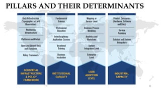
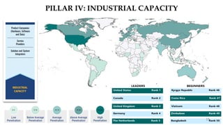
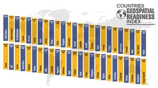
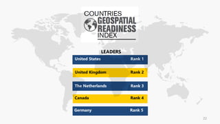
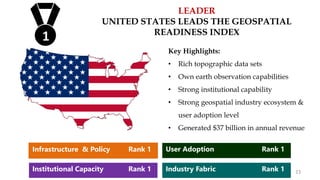
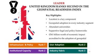
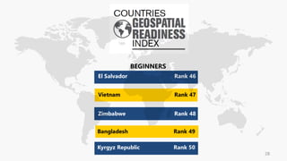
1
Presenter:
Ms. Anamika Das
Vice President – Market Intelligence and Business Consulting
Ms. Anamika Das holds an M.Phil. in Geography from Delhi
School of Economics, Delhi University. She is currently the
Vice President of Market Intelligence & Business Consulting
wing. She has over 18 years of extensive experience in
geospatial field which includes over 6 years experience in
primary & secondary research and market analysis.
2
COUNTRIES
GEOSPATIAL
READINESS
INDEX
3
RELEVANCE OF GEOSPATIAL READINESS
High Geospatial Readiness
Enhanced use of Geospatial in all business sectors
because the economy is geo-ready
Sustainable economic growth
and prosperity 4
5
POLL QUESTION
Do you see a relevance of geospatial readiness
in countries national development goals:
a. Yes
b. Can’t Say
c. No
POLL RESULT
Do you see a relevance of geospatial readiness in countries national
development goals?
89.47%
10.53% 0.00%
Yes
Can't Say
No
7
SCOPE & BACKGROUND OF STUDY
Countries
Geospatial
Readiness Index
Determining
pillars, sub-pillars
and sub-themes
Conduct Primary
and Secondary
Survey
Formulate the
readiness score
Identifying 50
countries for the
index
8
COUNTRIES FOR GEOSPATIAL READINESS INDEX
50Geographically Distributed
countries chosen for Indexing from
the following Regions:
Asia-Pacific (APAC)
Europe
Americas
Africa & Middle East (AMEA)
75% of world’s population
90% (approx.) of world’s GDP
9
10
PILLARS AND THEIR DETERMINANTS
11
12
POLL QUESTION
Among the four pillars which according to you
is the most important in assessing a Countries
Geospatial Readiness Index
a. Data Infrastructure and Policy Framework
b. Institutional Capacity
c. User Adoption Level
d. Industry Fabric
Among the four pillars which according to you is the most important
for assessing a Countries Geospatial Readiness?
64.29%
3.57%
32.14%
0.00%
0.00%
10.00%
20.00%
30.00%
40.00%
50.00%
60.00%
70.00%
Infrastructure &
Policy
Instituional
Capacity
User Adoption
Level
Industry Fabric
POLL RESULT
PILLAR I: GEOSPATIAL INFRASTRUCTURE AND
POLICY FRAMEWORK
14
PILLAR II: INSTITUTIONAL CAPACITY
15
16
POLL QUESTION
According to you in measuring Institutional
Capacity which of the following sub-
determinant plays a major role:
a. Business Incubation
b. Fundamental Sciences
c. Interdisciplinary Courses
d. Professional Education
According to you in measuring Institutional Capacity which of the
following sub-determinant plays a major role?
POLL RESULT
40%
8%
32%
20%
0%
5%
10%
15%
20%
25%
30%
35%
40%
45%
Business Incubation Fundamental Sciences Interdisciplinary
Courses
Professional Education
PILLAR III: USER ADOPTION LEVEL
18
PILLAR IV: INDUSTRIAL CAPACITY
19
20
21
22
LEADER
UNITED STATES LEADS THE GEOSPATIAL
READINESS INDEX
Key Highlights:
• Rich topographic data sets
• Own earth observation capabilities
• Strong institutional capability
• Strong geospatial industry ecosystem &
user adoption level
• Generated $37 billion in annual revenue
1
Infrastructure & Policy Rank 1
Institutional Capacity Rank 1
User Adoption Rank 1
Industry Fabric Rank 1 23
LEADER
UNITED KINGDOM RANKS SECOND IN THE
GEOSPATIAL READINESS INDEX
Key Highlights:
• Location is a key component
• Geospatial adoption in every industry segment
• Abundant universities
• Supportive legal and policy frameworks
• £561 billion worth of economic impact
accredited to the adoption of geospatial
2
1
Infrastructure & Policy Rank 7
Institutional Capacity Rank 2
User Adoption Rank 2
Industry Fabric Rank 3 24
LEADER
THE NETHERLANDS RANKS THIRD IN THE
GEOSPATIAL READINESS INDEX
Key Highlights:
• Rich and diverse scales of topographic and satellite
imagery
• One of the first countries to establish cloud-based
web portal for real-time satellite data access
• Increased geospatial uptake in all industry
verticals
3
Infrastructure & Policy Rank 2
Institutional Capacity Rank 7
User Adoption Rank 3
Industry Fabric Rank 5 25
26
THE MIDDLE GROUND
INDIA RANKS AT 23RD IN THE GEOSPATIAL
READINESS INDEX
Key Highlights:
• Tremendous opportunities & enterprising
spirit
• Increased focus on geospatial capacity
building
• Strong service oriented industry fabric
• Weak Geospatial Infrastructure & Policy
23
Infrastructure & Policy Rank 36
Institutional Capacity Rank 15
User Adoption Rank 24
Industry Fabric Rank 19 27
28
Key Highlights:
• July 2016 – initiated the process of setting
up NSDI
• User adoption is presently low
• Very poor industry fabric
49
BEGINNER
BANGLADESH RANKS AT 49 IN THE
GEOSPATIAL READINESS INDEX
Infrastructure & Policy Rank 45
Institutional Capacity Rank 47
User Adoption Rank 47
Industry Fabric Rank 50 29
CONTACT US:
Ms. Anamika Das
Email: anamika@geospatialmedia.net
Twitter: @dasanamika
30

Geospatial readiness Index 2017 - Overview

  • 1.
  • 2.
    Presenter: Ms. Anamika Das VicePresident – Market Intelligence and Business Consulting Ms. Anamika Das holds an M.Phil. in Geography from Delhi School of Economics, Delhi University. She is currently the Vice President of Market Intelligence & Business Consulting wing. She has over 18 years of extensive experience in geospatial field which includes over 6 years experience in primary & secondary research and market analysis. 2
  • 3.
  • 4.
    RELEVANCE OF GEOSPATIALREADINESS High Geospatial Readiness Enhanced use of Geospatial in all business sectors because the economy is geo-ready Sustainable economic growth and prosperity 4
  • 5.
    5 POLL QUESTION Do yousee a relevance of geospatial readiness in countries national development goals: a. Yes b. Can’t Say c. No
  • 6.
    POLL RESULT Do yousee a relevance of geospatial readiness in countries national development goals? 89.47% 10.53% 0.00% Yes Can't Say No
  • 7.
  • 8.
    SCOPE & BACKGROUNDOF STUDY Countries Geospatial Readiness Index Determining pillars, sub-pillars and sub-themes Conduct Primary and Secondary Survey Formulate the readiness score Identifying 50 countries for the index 8
  • 9.
    COUNTRIES FOR GEOSPATIALREADINESS INDEX 50Geographically Distributed countries chosen for Indexing from the following Regions: Asia-Pacific (APAC) Europe Americas Africa & Middle East (AMEA) 75% of world’s population 90% (approx.) of world’s GDP 9
  • 10.
  • 11.
    PILLARS AND THEIRDETERMINANTS 11
  • 12.
    12 POLL QUESTION Among thefour pillars which according to you is the most important in assessing a Countries Geospatial Readiness Index a. Data Infrastructure and Policy Framework b. Institutional Capacity c. User Adoption Level d. Industry Fabric
  • 13.
    Among the fourpillars which according to you is the most important for assessing a Countries Geospatial Readiness? 64.29% 3.57% 32.14% 0.00% 0.00% 10.00% 20.00% 30.00% 40.00% 50.00% 60.00% 70.00% Infrastructure & Policy Instituional Capacity User Adoption Level Industry Fabric POLL RESULT
  • 14.
    PILLAR I: GEOSPATIALINFRASTRUCTURE AND POLICY FRAMEWORK 14
  • 15.
  • 16.
    16 POLL QUESTION According toyou in measuring Institutional Capacity which of the following sub- determinant plays a major role: a. Business Incubation b. Fundamental Sciences c. Interdisciplinary Courses d. Professional Education
  • 17.
    According to youin measuring Institutional Capacity which of the following sub-determinant plays a major role? POLL RESULT 40% 8% 32% 20% 0% 5% 10% 15% 20% 25% 30% 35% 40% 45% Business Incubation Fundamental Sciences Interdisciplinary Courses Professional Education
  • 18.
    PILLAR III: USERADOPTION LEVEL 18
  • 19.
  • 20.
  • 21.
  • 22.
  • 23.
    LEADER UNITED STATES LEADSTHE GEOSPATIAL READINESS INDEX Key Highlights: • Rich topographic data sets • Own earth observation capabilities • Strong institutional capability • Strong geospatial industry ecosystem & user adoption level • Generated $37 billion in annual revenue 1 Infrastructure & Policy Rank 1 Institutional Capacity Rank 1 User Adoption Rank 1 Industry Fabric Rank 1 23
  • 24.
    LEADER UNITED KINGDOM RANKSSECOND IN THE GEOSPATIAL READINESS INDEX Key Highlights: • Location is a key component • Geospatial adoption in every industry segment • Abundant universities • Supportive legal and policy frameworks • £561 billion worth of economic impact accredited to the adoption of geospatial 2 1 Infrastructure & Policy Rank 7 Institutional Capacity Rank 2 User Adoption Rank 2 Industry Fabric Rank 3 24
  • 25.
    LEADER THE NETHERLANDS RANKSTHIRD IN THE GEOSPATIAL READINESS INDEX Key Highlights: • Rich and diverse scales of topographic and satellite imagery • One of the first countries to establish cloud-based web portal for real-time satellite data access • Increased geospatial uptake in all industry verticals 3 Infrastructure & Policy Rank 2 Institutional Capacity Rank 7 User Adoption Rank 3 Industry Fabric Rank 5 25
  • 26.
  • 27.
    THE MIDDLE GROUND INDIARANKS AT 23RD IN THE GEOSPATIAL READINESS INDEX Key Highlights: • Tremendous opportunities & enterprising spirit • Increased focus on geospatial capacity building • Strong service oriented industry fabric • Weak Geospatial Infrastructure & Policy 23 Infrastructure & Policy Rank 36 Institutional Capacity Rank 15 User Adoption Rank 24 Industry Fabric Rank 19 27
  • 28.
  • 29.
    Key Highlights: • July2016 – initiated the process of setting up NSDI • User adoption is presently low • Very poor industry fabric 49 BEGINNER BANGLADESH RANKS AT 49 IN THE GEOSPATIAL READINESS INDEX Infrastructure & Policy Rank 45 Institutional Capacity Rank 47 User Adoption Rank 47 Industry Fabric Rank 50 29
  • 30.
    CONTACT US: Ms. AnamikaDas Email: anamika@geospatialmedia.net Twitter: @dasanamika 30