Frank Kwak, president of the Fraser Valley Salmon Society, takes a reporter to Gill Bar on the Fraser River to show them one of the gravel bars being mined under the province's flood protection program. Kwak believes the program's stated goal of flood protection is misleading and the gravel is actually being removed for private profit. Critics like retired fisheries biologist Otto Langer question whether flood risk is the true motivation, or if it is being used to subsidize the local aggregate industry. While the program claims to be protecting homes and infrastructure from floods, some experts argue the science does not support the locations chosen for gravel extraction and the work could be harming fish habitat.
Restoration experts from Ducks Unlimited, The Nature Conservancy, and the Lower Fox River/Green Bay Areas of Concern will discuss case studies of partnerships turning federal GLRI funding into successful on-the-ground habitat restoration projects that provide a variety of ecological and societal benefits that can be sustained well into the future. Featured case studies include successfully restoring coastal marsh for waterbirds and for northern pike, using watershed-based GIS planning tools to prioritize restoration projects, and the reestablishment of the Cat Island Chain of islands in lower Green Bay. This presentation was given by Janet Smith, Chair of the Biota and Habitat Work Group of the Science and Technical Advisory Committee for the Lower Fox River/Green Bay Area of Concern, Retired U.S. Fish and Wildlife Service.
The document summarizes the decline of the African penguin population due to various environmental pressures. It notes that their numbers have dropped by over 95% since the early 1900s due to overfishing reducing their food supply, climate change altering ocean currents and temperatures which affects fish distribution, and pollution like oil spills that can contaminate penguins. Conservation efforts aim to rehabilitate oiled or abandoned penguins and help manage fisheries and reduce pollution to improve conditions for the endangered penguins.
The slide show provides a visual tour of the Croton River Gorge and watershed. Teatown Lake Reservation is embarking on an outreach program called ELLA to train local environmental groups. There is also an effort to conserve the Croton River Gorge and watershed through an action plan with recommendations for the five municipalities. Teatown can help with education and coordination to implement the action plan.
This document summarizes a case study examining the potential impacts of dredging the entrance to the Lower Myall River on migratory shorebirds. It finds that dredging could negatively impact shorebirds through increased disturbances from recreational boating and dredging activities. Over 32 migratory shorebird species and 10 Australian resident shorebird species use the area, including globally significant populations of Eastern Curlew and Bar-tailed Godwits. The document recommends referring the proposal to the Commonwealth Government and conducting species impact statements on three threatened shorebird species. It discusses addressing concerns about unnecessary environmental reviews through scientific evidence and consultation with experts.
2013 03 fish in the severn estuary - richard seabySevernEstuary
The Severn Estuary Forum is a key annual event in its eighth year and hosted by the Severn Estuary Partnership: an independent, estuary-wide initiative, involving all those interested in the management of the estuary, from planners to port authorities, fishermen to farmers.
This year’s Forum was opened by the Lord Mayor of Gloucester and supported by CIWEM. It focussed on a number of diverse topics, including the upper estuary; renewable energy possibilities; a review of the Severn Estuary Flood Risk Management Strategy; an overview of the operations and maintenance of the Severn River Crossings; Local Enterprise Partnerships; The Bristol Deep Sea Container Terminal; proposals for a Severnside Airport and Fisheries amongst others.
These engaging and exciting events are intended for all interested in learning about the latest research and policy developments dealing with the Severn Estuary and its future, and always guarantee a lively and informative day of presentations and talks. They offer a unique opportunity to learn from others, share ideas and participate in the management of the Severn Estuary.
This document discusses wildlife crime in the UK and calls on paddlers to help monitor for such crimes. It notes that early spring sees an increase in wildlife crime due to longer days and breeding seasons. While the National Wildlife Crime Unit works to combat these crimes, they rely on public assistance as wildlife cannot report crimes. The document encourages paddlers to be vigilant while on the water and provides tips for reporting any suspected wildlife crimes witnessed. It also highlights several native UK wildlife species that are vulnerable to crime, such as badgers, bats, seals and birds of prey.
This presentation is given to the Snohomish County Beach Watcher Training Class every year. It covers salmon life cycle, cultural and social benefits of salmon, salmon habitat and stewardship.
1. The document discusses using oysters to restore water quality in the Fort Point Channel by taking advantage of opportunities for oyster restoration projects.
2. The Channel was originally a bay among wetlands but was altered by filling and dredging during industrialization, becoming narrower and more industrialized over time.
3. A survey of the Channel found many attractive areas that could support oyster colonies to filter water and involve the local community in restoration.
Environmental Health and Safety Survey - Brokers' Bay 2019LOWaterkeeper
Environmental Health and Safety Survey for Brokers' Bay recreational water quality monitoring program, Vancouver 2019. Swim Drink Fish recreational water quality monitoring hub.
A photographic tour of Moon Island and Long Island in Boston Harbor. Of particular interest is the former sewage storage facility on Moon Island and its potential for use in aquaculture.
Environmental Health and Safety Survey Vanier Park 2019LOWaterkeeper
This document summarizes an environmental health and safety survey of Vanier Park in Vancouver, BC. It identifies the park and swimming area, describes surrounding land uses and potential sources of contamination. Microbiological testing over 2019 found the water passed guidelines 90% of the time. Sources of contamination include nearby boats, stormwater runoff and wildlife. Physical hazards include strong currents, rocks and seaweed. The document assesses risks and considers mitigation barriers.
Pacific Spirit Park Society (PSPS) Environmental Health and Safety SurveyLOWaterkeeper
Water quality at this beach jointly monitored by Metro Vancouver and the Pacific Spirit Park Society (PSPS). Sampling is conducted by Metro Vancouver from May to October and by the Pacific Spirit Park Society from October to March.
Lake Winnipeg is a shallow lake located in Manitoba, Canada composed of two basins. It is on average only 12 meters deep and receives 517 mm of precipitation annually. Lake Winnipeg provides habitat for over 50 fish species including yellow perch, chestnut lampreys, and rainbow smelt. Yellow perch prefer temperatures between 18 to 20 degrees Celsius and feed on invertebrates and fish like emerald shiners. Chestnut lampreys are parasitic fish that attach to other fish like yellow perch to feed on their blood and tissues. Recently introduced, rainbow smelt are an invasive species that have decreased the emerald shiner population.
The document provides information on the history, economic value, stock status, environmental impacts, stakeholders, and current management of the American lobster fishery. It discusses how lobsters were once used as fertilizer but became a culinary prize, the development of trap fishing, and the history of management from the 1940s onward. Stock status varies by region, with Gulf of Maine and Georges Bank stocks increasing but Southern New England critically depleted. The fishery generates hundreds of millions annually for New England. Current management divides the fishery into areas and stocks and regulates effort and catch through limits. Recommendations focus on improving conditions for the Southern New England stock and considering ecosystem and spatial issues.
The document discusses fish sampling programs and results from the Illinois Department of Natural Resources in Region 2 streams. It summarizes the 2013 basin survey which sampled 34 stations and found 19,665 fish from 15 families and 70 species, including 2 listed species. The survey results from the Des Plaines River mainstem show the top 15 most numerous species collected. Dam removal studies discussed include the removal of Hoffman Dam in 2012 and other regional dam removals from 2011-2015 which have helped improve habitat connectivity and fish communities upstream of former dam sites.
The document provides an overview map of Montego Bay, Jamaica showing various existing land uses and infrastructure. It then discusses several key events that have impacted the coastal ecosystem of Montego Bay over the past 500 years, including development projects in the 1960s-1970s that filled in mangroves and reclaimed waterfront areas. The 800-acre master plan aims to increase coastal resiliency through a system of green and blue infrastructure while also introducing new public spaces and cultural hubs. The design targets various user groups and focuses on human-nature interactions and environmental education.
(See notes below) Four hundred years ago, the Chesapeake Bay that the English colonists found here was lined with huge oyster reefs that grew up from the bottom in waters both deep and shallow. Those reefs provided the base for much of the life in the Bay and its rivers, from worms and barnacles through mud crabs and tiny fish to big blue crabs and predators like sheepshead, drum, and rockfish (striped bass).
The oyster reefs weren’t as “pretty” (to us humans) as the coral reefs further south, but in terms of ecosystem richness, they were just as important. One key to their strength was their three-dimensional structure, which successive generations built gradually on the shells of their predecessors over several thousands of years. The structures placed the oysters up in the water column, away from gill-choking bottom sediments, where dissolved oxygen was plentiful and currents brought food in the form of algae cells seeking sunlight.
This PowerPoint presentation, developed by the Chesapeake Bay Foundation’s Fisheries Program Director Bill Goldsborough, tells the story of those reefs and what has happened to them over the past four hundred years. It is not a pretty story, but it offers a hopeful conclusion, as we learn more each year about how to restore these essential elements in the Chesapeake ecosystem.
Anglers have as much to gain as anyone in restoring the Chesapeake’s oysters. The presentation closes with suggestions for how to get involved in oyster restoration, and how to incorporate the restoration reefs into your 2015 angling season.
To participate in CBF’s oyster restoration programs in Virginia and Maryland, visit http://www.cbf.org/oysters.
1) Divers in South Africa regularly encounter sevengill sharks in the kelp forests off Miller's Point. The sharks are bold and inquisitive.
2) Researchers are studying these sharks to learn more about their population dynamics, as commercial fishing threatens the species. Divers help by photographing the sharks' unique markings to identify individuals.
3) The area around Miller's Point appears to be an important pupping ground for sevengill sharks, though more research is needed to confirm this. The sharks' long gestation period and late maturity make them vulnerable to overfishing.
Declining water quality on the Great Barrier Reef (GBR) has been linked to a long-term decline of coral cover within the GBR World Heritage area. GBR reefs are naturally exposed to river runoff carrying nutrient and suspended sediment loads, but historical and current land-use practices have enhanced the delivery of terrestrially derived material in to the marine environment. Regional water quality improvement plans are a mechanism to improve coastal water quality, through actions in the source catchments targeted at reducing sediment and nutrient delivery into streams, rivers and ultimately the marine receiving waters.
Hydrodynamic models currently being applied to the GBR as part of the eReefs project provide a valuable tool for identifying, quantifying and communicating the spatial impact of discharges from various rivers into the GBR lagoon. Using hindcast simulations of historic wet seasons, river-tagged passive tracers were released from major rivers discharging into the GBR to provide a quantitative identification of high or extended exposure of spatial regions to river plumes. Simulated river exposures were coupled with estimated river nutrient loads to inform a spatial risk analysis of reef exposure to terrestrially derived pollutants. This modelling provided a quantitative basis for prioritizing catchments for management attention, and has informed the refinement of regional water quality improvement plans.
The document discusses the aims and objectives of an organization to conserve and protect native fish populations through regular monitoring, research, collaboration, and education. It summarizes studies on juvenile salmonid abundance and describes an integrated approach to analyzing limiting factors, habitat improvements, and genetic conservation. The document also outlines various freshwater habitat problems negatively impacting salmon and sea trout populations, such as land drainage, intensive livestock grazing, artificial obstructions, and hydrological changes.
The U.S. Department of Interior will make a decision on whether they plan to lease the North Aleutian Basin (Bristol Bay) for offshore oil and gas drilling that could jeopardize fisheries, wildlife and the communities they support while offering few jobs and benefits to local residents.
Be Involved: Attend a presentation and discussion! Hear the facts, discuss the proposal, and learn how to comment to decision-makers by the September 21st comments deadline. There will be refreshments, information and a chance to sound off! It’s free and open to the public.
Tuesday August 25th: 7pm @ the Sand Point City Council Chambers
If you cannot join in person, call in by teleconference!
Call toll free: 866-469-3239, passcode 56213498.
Questions or need more information? Visit www.protectfishing.wordpress.com
Sponsored by World Wildlife Fund
The document discusses the proposed Pebble Mine in Bristol Bay, Alaska. It would be a massive open-pit gold and copper mine that threatens to pollute the watershed and disrupt the salmon fishery. The Bristol Bay fishery supports over 10,000 jobs and is the world's largest sockeye salmon fishery. Opponents argue the mine poses too great a risk to the fishery and wildlife. The EPA will release a scientific assessment of the mine's environmental risks in April 2012.
The Buzzards Bay Coalition protected over 200 acres around Allens Pond in Dartmouth, one of the largest land conservation projects in Buzzards Bay's history. The Coalition also continued to expand septic system pilot projects around the bay to reduce nitrogen pollution by 80% and protected nearly 1500 acres of land in the Mattapoisett River Valley over the past 15 years to protect drinking water sources.
This document summarizes the 2011 State of Buzzards Bay report. The overall score for Buzzards Bay remained at 45 out of 100, as improvements in reducing old pollution sources were offset by increasing nitrogen pollution from development. Specifically:
- Nitrogen pollution decreased the score 3 points to 53, as septic systems continue to be the largest source of nitrogen entering the bay.
- Bacteria levels improved 5 points to 62, though shellfish harvesting remains closed in many areas due to contamination.
- Toxics improved 5 points to 52, though legacy pollution continues to impact areas like New Bedford Harbor.
- Forest and wetland coverage showed little change, while development continues to destroy coastal habitats.
Christmas tree tops are pinned down in flood conditions to trap silt, which is then planted with willow twigs to stop erosion. Willow weaving is used to protect riverbanks by weaving willow lengths around posts. Rock ramps are constructed to help migrating fish pass over barriers like bridge sills in low water conditions.
Carmarthenshire's coastline features beautiful sandy beaches along the Gulf of Carmarthen. Some of the notable beaches include Pendine beach, with its dramatic cliffs and rock pools to the west and long sandy beach to the east. Laugharne beach is famous as a place of inspiration for Dylan Thomas. Llansteffan beach has views of Llansteffan Castle across the river estuary. The Millennium Coastal Park stretches 22 km along the coast and features attractions, wildlife, and beaches.
FreshlyPicked is a mobile app that aims to reduce food waste by providing personalized shopping recommendations. Americans throw away $165 billion worth of food annually and the average household wastes $2,200 per year. The app analyzes internal user data like demographics and habits as well as external factors like store prices and brands to make informed suggestions about what to buy and how to use it. This integrated approach seeks to decrease waste while optimizing grocery spending.
Ada tiga jenis penguncupan otot: isometrik (statik) yang tidak menghasilkan pergerakan tetapi daya, isotonik yang memendekkan otot untuk menghasilkan daya, dan isokinetik yang menguncup otot pada kecepatan tetap. Terdapat dua jenis serat otot - serat cepat untuk aktiviti intensitas tinggi dan serat lambat untuk aktiviti aerobik jarak jauh.
El documento describe el modelo cognitivo conductual, el cual analiza cómo los pensamientos, creencias y emociones influyen en el comportamiento. Explica que la terapia cognitivo-conductual busca identificar y modificar los patrones de pensamiento disfuncionales para reemplazarlos con pensamientos más adaptativos. También describe las diferentes fases del modelo conductual y las técnicas utilizadas en la terapia cognitivo-conductual como la reestructuración cognitiva y el entrenamiento de habilidades.
Dokumen tersebut membahas tentang sistem reproduksi manusia, meliputi organ reproduksi pria dan wanita beserta fungsinya, proses pembentukan sperma dan ovum, fertilisasi, pertumbuhan embrio, siklus menstruasi, dan beberapa kelainan pada sistem reproduksi."
The document discusses establishing homestead fruit gardens in villages to increase productivity and farmer income. Most homesteads currently have low productivity and are planted with timber trees. Some farmers have found success planting fruits like jujube, papaya, and lemon. The objectives are to increase homestead productivity and farmer income. Activities conducted so far include workshops to link farmers to seedling producers, buyers, and input sellers. The future strategy is to establish 500 homestead fruit gardens in Noakhali district, planting an average of 20 seedlings per garden. This could generate over 1,000,000 Taka in additional annual income. Specific activities will provide training, linkages, demonstrations and market visits to support establishing mini-orchards
This document provides information about the Eugene Field Park Aquatic Ecosystem Restoration Program that took place from 2011-2016. The project involved restoring a 10-acre urban park and stream area by removing invasive plants and filling, constructing rock check dams in the river, excavating 20,000 cubic yards of fill to restore historic wetland depressions, and planting over 100 native plant species. Monitoring showed the restored areas became colonized by muskrats and plant growth was successful except along the river bank, demonstrating progress towards restoring the park's natural aquatic ecosystem.
The document discusses the proposed Keystone XL pipeline that would transport crude oil from Canada through the U.S. to Texas. It notes concerns about the pipeline's proposed route through Nebraska's ecologically sensitive Sandhills region, which contains important wetlands and groundwater resources. While the pipeline may provide economic benefits, there are environmental risks like contamination from potential oil spills that could harm the Sandhills and Ogallala Aquifer. The document examines these issues and potential impacts through maps, photos from the Sandhills region, and discussions of previous pipeline oil spills.
The annual Gem-O-Rama show in Trona, California attracts thousands of visitors each year to see rare crystals and minerals. The show, run by the local gem and mineral society, has grown significantly over the past 20 years according to organizers. An estimated 4,000 people now attend to see the crystals found in the solution mine tunnels and learn about the geology of the area. The small town of Trona relies heavily on tourism from this unique annual event.
This document provides a chronology of development along the Current River in Thunder Bay, Ontario from 1823 to present day. It describes how the river was initially used by Indigenous peoples and explored by European settlers in the 1800s. The first major development was a stamp mill built at the river's mouth in 1866 to process ore from a nearby silver mine. Over time, more mines, docks, and other industrial activities were established along the lower reaches of the river. By the late 1900s, the river's ecology had been degraded but rehabilitation efforts are now underway to restore fish habitat and populations through projects like a fish ladder installed in 1991. The document aims to outline the history of human impacts to inform management strategies to rehabilitate
This document provides an overview of a proposed wave energy project off the coast of the Makah Tribe's reservation in Neah Bay, Washington. The project would involve installing buoy devices in the ocean that harness the kinetic energy of waves to generate electricity. The proposal was brought to the Makah Tribe by Alla Weinstein's company AquaEnergy Group. While securing permits has been challenging, if approved the project could provide a renewable source of electricity for the Makah Tribe and help diversify their economy which relies heavily on seasonal fishing. The project faces scrutiny from the Olympic Coast National Marine Sanctuary which must ensure any development does not harm the sensitive marine environment.
The village of Boscastle in Cornwall, UK suffered severe flooding in August 2004 when 89mm of rain fell in one hour. The heavy rainfall combined with the steep, narrow valleys and impermeable soil meant water quickly overwhelmed the narrow river channels running through the village. Over 150 people had to be rescued by helicopter and many homes and businesses were damaged by the floodwaters.
Mining can have significant negative impacts on water resources through water pollution and depletion. For every tonne of copper extracted, 99 tonnes of waste rock and tailings must be removed, generating massive amounts of waste. This waste is a major source of water pollution through acid mine drainage and heavy metal leaching. Mining also increases erosion and sedimentation risks. Past mining has left lasting legacies of contaminated water that are expensive to remediate and have damaged fisheries and ecosystems. Improved regulations and practices are needed to better prevent water pollution and protect water resources for future generations.
The opening of the St. Lawrence Seaway in 1959 unintentionally unleashed a biological plague on the Great Lakes. The Seaway allowed ocean freighters access to the lakes for the first time, and these ships dumped billions of gallons of untreated ballast water containing foreign species. Many of these invasive species caused profound ecological changes, including the proliferation of quagga and zebra mussels that depleted food sources for fish. While the Seaway provided some economic benefits, it has had major environmental costs including the introduction of over 50 invasive species that have disrupted fisheries and ecosystems. The lakes remain under threat from additional invaders like Asian carp spreading from other waterways.
The document discusses several negative environmental impacts that can occur during the construction and operation of inland waterways, including:
1. Capital dredging for initial channel creation can physically damage river beds and habitats, increase turbidity, and impact aquatic flora and fauna. Maintenance dredging is also required.
2. Construction of ports, jetties and other infrastructure can remove trees and mangroves, restrict access to rivers, and displace people through land acquisition.
3. Barge movement increases erosion, turbidity, noise, and loss of fish catch, impacting the livelihoods of fishing communities. Accidents can also pollute rivers.
- The document describes a multi-day float trip down the North Fork of the White River in southern Missouri Ozarks to experience the river's unique fishery.
- The river starts as a smallmouth bass river then transitions at Rainbow Springs to a trout fishery, with brown trout and wild rainbows, one of the last undammed coldwater fisheries in the Ozarks.
- The group recreated a historic float using traditional Ozarks johnboats to experience different angling techniques for smallmouth and trout along the various sections of the river.
The document summarizes the 2004 Boscastle flood in Cornwall, England. It describes how heavy rainfall caused flash flooding in the town, with over 185mm of rain falling in just a few hours. The floodwaters rose rapidly, damaging homes and businesses and injuring some residents. While no lives were lost, the economic effects on the town's tourism-dependent economy were long-lasting as accommodations had to close for an extended period to recover. The document also discusses some of the factors that contributed to the flooding and measures taken to help prevent future floods.
Lafarge Brookfield Concerns Re Tire Burning: Impact on Shortts Lake and on waterway leading to the Shubie River, Cement Kiln Dust spread on Farmers' Fields, long term implications for health and the environment.
The Salton Sea was once a popular recreational destination for tourism, fishing, and water sports, attracting over 1.5 million visitors annually at its peak. However, rising salinity, shoreline flooding from agricultural runoff, and other environmental issues in the 1970s caused visitor numbers to sharply decline. Today, the Salton Sea is highly saline and ecologically unstable, experiencing massive fish die-offs. Its receding waters risk exposing large areas of dry playa soil that could release dust laced with toxic chemicals from farm runoff, worsening air quality issues for nearby residents. Solutions have been debated for decades with no clear path forward to address the massive environmental problems facing the Salton Sea.
Testing and Implementation of AMD Mitigation, Alum Gulch-Flux Canyon, Cox Gul...Daniel Eyde
The document summarizes a plan to mitigate acid mine drainage (AMD) and heavy metals in several tributaries in southeastern Arizona that flow into Sonoita Creek and Patagonia Lake. The plan involves installing gabion retaining wall structures and stream bed footers containing zeolite materials downstream of mine discharge points to raise pH and reduce metals like zinc, cadmium, lead, and copper. Water quality and biological monitoring will occur before and after installation to evaluate effectiveness. Zeolites are effective at absorbing metals and raising pH, as shown in previous studies. The structures are intended to last 5-10 years before material replacement depending on runoff conditions.
This document provides biographical and contact information for Jingyi "Jessy" Qiu along with descriptions of landscape design projects she has worked on. It lists her contact information, including address, phone number, and email at the top. Below this it outlines 20 design projects she has been involved in, providing titles, locations, time periods, and brief descriptions. The projects range from academic to professional and include designs for recovering landscapes, gardens, plazas, and launching areas.
Early on a spring morning in the town of Damascus, in northeastern.docxjacksnathalie
Early on a spring morning in the town of Damascus, in northeastern Pennsylvania, the fog on the Delaware River rises to form a mist that hangs above the tree-covered hills on either side. A buzzard swoops in from the northern hills to join a flock ensconced in an evergreen on the river’s southern bank.
Stretching some 400 miles, the Delaware is one of the cleanest free-flowing rivers in the United States, home to some of the best fly-fishing in the country. More than 15 million people, including residents of New York City and Philadelphia, get their water from its pristine watershed. To regard its unspoiled beauty on a spring morning, you might be led to believe that the river is safely off limits from the destructive effects of industrialization. Unfortunately, you’d be mistaken. The Delaware is now the most endangered river in the country, according to the conservation group American Rivers.
That’s because large swaths of land—private and public—in the watershed have been leased to energy companies eager to drill for natural gas here using a controversial, poorly understood technique called hydraulic fracturing. “Fracking,” as it’s colloquially known, involves injecting millions of gallons of water, sand, and chemicals, many of them toxic, into the earth at high pressures to break up rock formations and release natural gas trapped inside. Sixty miles west of Damascus, the town of Dimock, population 1,400, makes all too clear the dangers posed by hydraulic fracturing. You don’t need to drive around Dimock long to notice how the rolling hills and farmland of this Appalachian town are scarred by barren, square-shaped clearings, jagged, newly constructed roads with 18-wheelers driving up and down them, and colorful freight containers labeled “residual waste.” Although there is a moratorium on drilling new wells for the time being, you can still see the occasional active drill site, manned by figures in hazmat suits and surrounded by klieg lights, trailers, and pits of toxic wastewater, the derricks towering over barns, horses, and cows in their shadows.
The real shock that Dimock has undergone, however, is in the aquifer that residents rely on for their fresh water. Dimock is now known as the place where, over the past two years, people’s water started turning brown and making them sick, one woman’s water well spontaneously combusted, and horses and pets mysteriously began to lose their hair.
Craig and Julie Sautner moved to Dimock from a nearby town in March 2008. They were in the process of renovating their modest but beautifully situated home on tree-canopied Carter Road when land men from Houston-based Cabot Oil & Gas, a midsize player in the energy-exploration industry, came knocking on their door to inquire about leasing the mineral rights to their three and a half acres of land. The Sautners say the land men told them that their neighbors had already signed leases and that the drilling would have no impact whatsoever on their land. (Othe ...
The Dead Sea is located between Israel, the West Bank, and Jordan. It is the lowest place on earth at over 1,300 feet below sea level. The Dead Sea is drying up due to reduced water flows from the Jordan River and mineral extraction activities, causing its level to drop over 1 meter per year. This is creating environmental, economic, and social problems like thousands of sinkholes developing along its shores. Proposed solutions include a canal to bring water from the Red Sea, but opponents argue this could fundamentally change the Dead Sea's composition.
The document discusses the proposed designation of the Boulder-White Clouds area in Idaho as a national monument and its importance for protecting fish habitat and recreational fishing opportunities. Specifically:
- The area contains headwaters of several major salmon and steelhead rivers and provides critical spawning habitat, but fish populations have declined sharply from threats including grazing, mining, and dams downstream.
- A national monument could help protect spawning and rearing areas from further degradation while also building support for addressing threats downstream.
- The area offers world-class trout fishing in alpine lakes like the Boulder Chain Lakes as well as rivers like the Big Lost and Big Wood, but protection is needed to preserve the fisheries for future
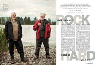
1. July 2010 BCBusiness 207206 BCBusiness July 2010
rockbetween a
hardand a
place
b y T y e e Br i d g e
p h o t o g r a p h y b y H u be rt K a n g
fraser fight:
Activist Frank Kwak
(left) and researcher
Otto Langer are
concerned gravel
removal is harming
Fraser River fish for
no good reason
Isthemultimillion-dollargravelextractionprogramonthe
FraserRiveractuallysavinglives–preventingadevastatingflood,as
governmentofficialsclaim? Orisitjustpaddingthepocketsofalucky
fewandcausingirreparableharmtoafragileecosystem?
When I meet Frank Kwak, he’s in his
backyard planting dahlias, wearing black
polyester running pants tucked into a pair
of gumboots. Screened on the back of his
white T-shirt is a leaping largemouth bass.
He’s agreed to take me out to the Fraser
RiverandshowmeGillBar,akilometre-long
gravel bar near Chilliwack that’s become
the latest focal point in a decade-long battle
over gravel mining in the Fraser. After we
get into my car, Kwak pulls out an unpeeled
orangeandanenergybar.“Sorryaboutthis,”
he says. “I haven’t gotten around to break-
fast yet.”
Kwak, 62, is a busy man. The president
of the Fraser Valley Salmon Society, he sits
on “well over 20” committees dealing with
sport-fishing issues and river habitat. Ten
yearsago,hetookearlyretirementsoheand
his wife could move to Chilliwack, where
through a local church they worked with
refugees from Kosovo and later launched
their own Christian ministry to feed the
city’s homeless and hungry. A fly fisher-
man, Kwak soon found that the valley was,
if not an angler’s Canaan, at least a decent
place for a retiree to enjoy weekends fish-
ing for steelhead trout and salmon. But over
the next decade, his attempt at a relaxing
hobby led him into the fraught politics of
fishandwater.Hishomelessministryisnow
a reduced-fee catering company, and these
days he makes fewer hot meals than confer-
ence calls.
Kwakdownplayshisknowledgeofstream
ecology and fish habitat. “I don’t know really
very much,” he says. “I’m just a grunt and a
willing participant.” Still, Kwak has been
known to get his hands in the gravel, which
at least once has landed him on the front
page. In 2006, while exploring a channel
island called Big Bar, he found thousands
of exposed, dried-up “redds”: scooped-out
nests of fertilized eggs left in the fall by
spawning salmon. An access road built to
thebarbyalocalgravelcompanyhadcutoff
thespawningchannelanddrieditup,killing
an estimated two million pink salmon fry. It
was one of the largest documented fish kills
inrecentB.C.history.ThepinkkillatBigBar
was big news at the time for being a major
botch but also because it raised old ques-
tionsaboutgraveloperationsintheFraser –
questions that remain unsettled.
2. bcbusinessonline.ca July 2010 BCBusiness 209
in its well-washed gravel come here to
die: millions of chum and up to 10 million
humpbacked pinks in alternate years.
Otto Langer is a retired fisheries biolo-
gist who spent 32 years with Fisheries and
Oceans Canada, colloquially known as the
DFO (after its former name, the Depart-
ment of Fisheries and Oceans). Like many
others concerned about fish habitat in the
Fraser, he questions the motives for gravel
extraction. “The program as it’s presently
being sold is misleading, and there’s obvi-
ously more than a flood-control agenda
being pushed at this time,” says Langer,
who has spent a good part of his retire-
ment years compiling a massive file on
gravel extraction in the Fraser River. He
and Marvin Rosenau (of BCIT’s fish, wild-
life and recreation program), along with
John Werring of the David Suzuki Foun-
dation, the B.C. Wildlife Federation and
othergroups,haveformedtheFraserRiver
Gravel Stewardship Committee to lobby
the government on the impact of gravel
mining in the Fraser.
In a review of the DFO’s role in Fraser
gravel extraction released last March,
Langer notes that gravel mining in B.C.’s
rivers has had a long and occasionally
smelly history. Over the past century,
construction companies and others in the
Fraser Valley, writes Langer, “have often
extracted the clean gravels from salmon
spawning streams as a local source of
cheap aggregate for roads and making
concreteforconstructionprojects....Min-
ing gravel from the Coquitlam River in the
Lower Mainland destroyed much of the
river’s habitat and drove a healthy run of
pink salmon into extinction. Indeed, some
40 years ago, construction workers in the
area complained that concrete made from
Coquitlam River gravels gave off a bad rot-
ten salmon smell due to the large numbers
of salmon eggs in the concrete.” On the
nearby Fraser, extractions continued up
until about 1998 when the DFO asked for
and “largely got” a moratorium on gravel
mining – not completely, as small “experi-
mental” removals continued – pending an
overall management plan for salmon and
fish habitat in the river.
But the pressure to reopen it was per-
sistent. A report on aggregate supply for
theprovincialMinistryofEmploymentand
Industry in 1996 noted a dwindling aggre-
gate supply in the Fraser Valley and thus
“increasing demand on Upper Fraser Val-
ley sources, particularly the Fraser River
gravelbarspossessinghigh-qualitygravel.”
In 2002, after a four-year break, the gov-
ernment allowed mining to resume.
I
t’s a sunny day in late April, and as
Frank Kwak and I drive over the dike
we can see the river shining through
the cottonwoods. We park and Kwak
leads me back onto the dike, an elevated
gravel road set back 150 metres from the
river. Five minutes later, he spots the place
he’s looking for and we make our way back
down. We wade through the knee-high
grass to the riverbank and see a seal poke
its head out of the water near the shore. “If
they say there’s not fish in here, well,” says
Kwak, “obviously there is.”
The seal looks at us with something
like amusement, but Kwak isn’t smiling.
The seal is about 80 metres from Gill Bar,
which is one of about a dozen bars mined
for gravel in the past 10 years and the
otto Langer (bottom right)208 BCBusiness July 2010
Gravel extraction in the Chilliwack
area of the river has been going on by
private aggregate companies for decades.
Since 2004 the operations have increased
in size and number, ostensibly to protect
$6-billion worth of homes, businesses and
public infrastructure in the Fraser Valley
from a New Orleans-style flood – like the
granddaddyFraserfloodof1894ortheone
that devastated the region in 1948. While
private companies are still mining the
gravel, their operations are now approved
and conducted under the auspices of
Emergency Management B.C. (EMBC), part
of the provincial Ministry of Public Safety
and Solicitor General. But a growing num-
ber of biologists, local First Nations and
river hydraulics experts – as well as sport
fishermenlikeKwak–questiontheofficial
story of flood protection and worry that
the program is really a means of subsidiz-
ing a local resource industry. By framing
gravel mining as an “emergency” public
safety work, say critics, the government
is quashing public input and ecological
review – and using up limited flood-pro-
tection funds.
“I’m pretty well convinced this is a
gravel grab that has very little to do with
flood protection,” says Kwak as we step
out of the car. “It’s done under the guise
of flood protection, but the gravel is being
removed for profit. Who all is profiting
from it I’m not sure.”
G
ravel is not sexy. The fortunes
of B.C.’s $300-million-a-year
aggregate industry – sand,
gravel and crushed rock – go
undiscussed at cocktail parties, despite
ourblinddependenceonthem.Gravelisas
basictomodernsocietyasflouristobread
baking; it’s a main ingredient for roads,
home foundations, sidewalks, schools,
bridges and hospitals. Construction and
road maintenance projects require about
54 million tonnes of aggregate a year, an
average of 12 tonnes for each person in
B.C. The Metro Vancouver market alone
is valued at $135 million, consuming about
15 million tonnes of gravel and sand every
year–roughlyequaltotheweightofabout
158,000 Boeing 757s – with most of that
gravelcomingfromtheSecheltareaonthe
Sunshine Coast.
The Fraser Valley market, on the other
hand, is much smaller, with about 800,000
tonnes of sand and gravel (plus another
600,000tonnesofcrushedrock)consumed
annually. Inamarketthissize,theexposed
gravel bars of the 65-kilometre stretch of
theFraserRiverbetweenMissionandHope
– known as the “gravel reach” or the Heart
of the Fraser – start to look pretty appeal-
ing: if costs for building access bridges and
roadstothebarsarecovered,astheyoften
are, by the province under the EMBC flood
protection program, gravel is relatively
clean and easy to access.
The reach is where all the gravel car-
ried by the river is deposited in a braided
alluvial fan – gravel that originates from
the weathering rock of the Fraser Canyon
above Hope or is delivered into the Fraser
by mountain streams and landslides. The
reach is also prime habitat for 30 species
of fish – including steelhead, pikeminnow,
shiners and endangered white sturgeon
– and the passageway for salmon headed
to and from their spawning beds. Droves
of pink and chum salmon that were born
rich riverbed: Thousands of tonnes
of gravel are taken from sites such as
Big Bar in Chilliwack each year and sold
in the construction market. Authorities
say the gravel mining is necessary
for flood protection
3. bcbusinessonline.ca July 2010 BCBusiness 211
is coming into the stretch and not moving
through or past the [gravel reach] . . . the
gravelissettlingontotheriverbedandthe
riverbed is building up. And because the
river is diked, that causes people to begin
managing the river, at least slight portions
of it, to minimize flood risk and meet other
objectives as well.”
Which raises the question, How much
gravel has actually built up in the Fraser?
AccordingtoMichaelChurch,aretiredUBC
professor of geomorphology and hydrol-
ogy, an average of 230,000 cubic metres
of gravel settles in the riverbed between
Hope and Mission every year. If you could
spreaditevenlythroughoutthechannel,it
adds up to about three millimetres a year,
or about 15 centimetres since the 1948
flood. But this is an artificial number, as
gravel is not deposited evenly throughout
the reach. BCIT’s Rosenau points out that
due to erosion by the river itself, which
carries existing deposits farther down-
stream when the freshet is running high,
there are large sections – a 22-kilometre
stretch between the Sumas and Harrison
rivers, for instance – that have lost large
volumes of gravel over the last 10 years.
“Flood protection is very much a specific
and local matter of removing gravel from
where it is building up,” he says. “Manag-
ing flooding in the river to some sort of
artificial sediment budget number over
the entire reach, as the government is cur-
rently doing, is just plain loopy.”
Church adds that “the entire program
[of gravel extraction] is highly experimen-
tal,” and that “in almost every case in the
worldwheregravelhasbeenremovedfrom
a river, it has been removed in volumes
greatly in excess of input, which is almost
never known, and the river has promptly
collapsedintoaditch-likeformwithdrastic
consequences for the riverine ecosystem.”
While removal might still afford a means
of flood protection to complement raising
dikes, Church believes that “the rational
solution” would be to limit the number of
homes, businesses and farms on the flood
plain, “indeed, to start reassembling sec-
tors of the flood plain for preservation as
floodable wetland.” But he acknowledges
that homeowners, the business commu-
nity, farmers and real estate developers
are unlikely to find this appealing, to say
the least.
While his research has been used by
EMBC to justify the extraction program,
Church is largely critical of the govern-
ment’s chosen flood-mitigation projects
to date, calling the 2006 Big Bar extrac-
tion “not an optimal choice” and the 2008
Spring Bar extraction “a very poor choice.”
His opinions are based, he says, on the
notion that gravel should only be removed
from zones where it chronically accumu-
lates, and “only Gill Bar lies in one of those
zones.” Quotedina2008articleintheGlobe
and Mail, Church went even further, saying
that it was “misleading” for government to
say there was a flood risk at Seabird Island
because gravel has not been building up
at Spring Bar. The reach where Spring Bar
lies, he told the reporter, has “on the whole
been degrading – that is, it has been losing
gravel for several decades now.”
Peter Ward of UBC’s civil engineering
department, one of Church’s colleagues,
concurred. “As a hydrology engineer who
has been involved with matters concern-
ing Fraser River flooding for many years,
I am surprised about why this project [at
Spring Bar] could possibly be justified on
the basis of flood control,” he said in a sep-
arate written opinion issued around the
same time, adding that it “looks as though
someoneproceededwiththeconstruction
work without getting or listening to com-
petent advice.”
S
oifgravelremovalprojectshave
not been chosen for flood con-
trol, then why? Critics of the
program point to the money to
bemadefromgravelsalesandgovernment
grants. Between 2005 and 2009, the prov-
incespent$16.6milliononfloodprotection
programs in the Fraser Valley, including
dikeimprovementsinMission,Abbotsford
210 BCBusiness July 2010
largest extraction site of 2010. In Febru-
ary K & L Contractors Inc., a local gravel
company, was given a “Section 9” permit
by the B.C. Ministry of Environment to
work “in and about a stream,” allowing the
company to mine 185,000 cubic metres of
gravel from the bar, about 310,000 tonnes.
More than 10,000 truckloads were hauled
fromthebaronatight10-weektimeline;K
& L had to beat the rising meltwaters that
now covered most of the bar.
Rivers are wild; they can be tamed but
they remain unpredictable. The big flood
of 1948 is still vivid in the memories of
Fraser Valley elders, and the stories trou-
bleanyonewholivesinthearea,especially
those who have stood on the dikes dur-
ing spring thaw and watched the river
roar by. Following another flood scare in
2007, the province agreed to add $100
million to a $60-million, 10-year invest-
ment by the federal government aimed at
improving area dikes and instituting other
flood-protection measures. But residents
are still nervous and want to believe that
authorities are doing everything they can
to protect their homes, families and busi-
nesses. That is why, Kwak says, EMBC’s
gravel extraction program has held such
popular appeal.
“It’s a pretty positive move on behalf
of provincial and federal leaders to tell a
community they’re doing everything they
can to prevent Chilliwack from flooding
in a freak flood. Can it happen? Well, of
course,” he says. “And so for Joe Q. Public,
if his ministers or MLAs tell him that there
is a chance the river will flood someday
– and that what we are doing and what
we’ll continue to do is protect your prop-
erty by removing gravel from the river
– he’ll be quite happy to hear that. If you
own a house in Chilliwack and could care
less about fish and there’s a one in a thou-
sand chance of a flood, you’re going to say,
‘Well, let’s do it.’”
It’s not only Kwak who has questions
about the program and its raison d’être.
In early May, in an exchange at the B.C.
legislature, Delta South MLA Vicki Hun-
tington asked Environment Minister
Barry Penner to provide provincial stud-
ies of flood control in the Fraser Valley
from EMBC. “A number of months ago . . .
I also asked whether the minister or the
office of the solicitor general, the emer-
gency measures office, would provide the
scientific documents that sustained and
showed that gravel extraction was helpful
in flood control. I haven’t received those
documents,” she said. “I was wondering
whether the minister and his staff could
see fit to provide me with [that] . . . I see
no science that is indicating the gravel
removal is anything but of benefit to the
extraction companies.”
In addition to his position as envi-
ronment minister, Penner is the MLA for
Chilliwack and a key promoter of gravel
extraction in the Fraser. (A 2008 article
in the Chilliwack Times noted that gravel
removal was part of Penner’s political
platform in the 2001 and 2005 elections.)
Responding to Huntington’s questions,
Penner argued that the removals were
essential due to gravel building up on the
river bottom. “I know that it doesn’t rise
equallyanditdoesn’triseineverylocation
all the time, but over time we know that as
youdepositsomethinginaconfinedspace,
that area will start to fill up.” He rejected
Huntington’s suggestion that the pro-
gram’s only real benefit was to extraction
companies: “I appreciate that the member
thinks there’s some kind of conspiracy,
but let me tell you that people living in the
Fraser Valley, I think, have every right to
expect flood protection.”
Dwayne Meredith is acting director
of EMBC’s Strategic Mitigation Program,
which oversees the gravel mining proj-
ects – or “removals” as the agency prefers
to call them – in the Fraser gravel reach.
When asked about the nature and motive
ofgraveloperationsinthereach,andifthe
way that it is done is explicitly for the pro-
tection of the public, Meredith’s answer
is unequivocal. “Absolutely,” he says. “As
time moves on and more and more gravel
In2006anaccess
roadbuilttothe
digsiteatBigBar
cutoffaspawning
channel,killing
anestimatedtwo
millionpink
salmonfry
otto Langer
4. bcbusinessonline.ca July 2010 BCBusiness 213
and Chilliwack. Of this, $2.6 million was
devoted to “sediment management” –
building access roads to gravel bars and
providing hydraulic studies and environ-
mentalmonitoring.Asaresult,contractors
extractedgravelon14occasionsfromnine
gravelbars,miningthemforapproximately
3.3 million tonnes of aggregate – worth, at
a minimum retail price for unprocessed
gravel, about $13.2 million.
The proponents of most extraction
operationsinthegravelreacharetwoFirst
Nations bands connected to the Sto:lo
Tribal Council (STC): the Seabird Island
Band near Agassiz and the Cheam Band
near Rosedale. These bands, which claim
traditional rights over several gravel bars
inthereach,workinpartnershipwithcon-
tractorswhopossesstheheavymachinery.
In 2008 Spring Bar became the largest and
most ambitious gravel-mining project in
the Fraser to date. Advocating extraction
was the 850-member Seabird band, which
awarded the mining contract to Jakes
Construction, a Chilliwack company that
handles everything from municipal sewer
upgrades to subdivision site preparation.
Jakes, as it happens, was also the contrac-
tor that built the access road to Big Bar
in 2006, inadvertently causing the pink
salmon kill.
Under the EMBC program, every con-
tractor who extracts gravelfrom the reach
is allowed to keep it for resale in lieu of
cash payment. In the case of Spring Bar,
Jakes was permitted to pull out and keep
570,000 tonnes of gravel – or well over half
the amount of sand and gravel sold in the
Chilliwack area in a given year. (Larger
operators can process gravel and create
a value-added product – clean pea gravel
or larger-sized drain rock sell for around
$26 a tonne – but smaller contractors
such as Jakes usually sell Fraser gravel as
is, directly from a pile, for about $4 per
tonne.) Jakes owner Jake Klaassen would
not go on record with his overhead costs,
but, according to industry sources, remov-
ing gravel from the Fraser reach can cost
anywherefrom$1to$3atonne.Whilemar-
gins are low, volume is high. At the going
rate for unprocessed gravel, the Spring
Bar operation resulted in the capture of an
asset worth roughly $2.25 million.
Turning gravel into cash is a long-term
proposition, however; half of the gravel
taken out of Spring Bar two years ago is
still sitting unsold, according to Klaassen.
“There is a market for the gravel, but
how can you show up at some vendor’s
door with 100,000 tonnes of gravel in one
month? They’re just not going to take it.
They’re going to say, ‘What do you want
me to do with these 10,000 truckloads?’”
Selling off the half-million-tonne pile from
Spring Bar, he says, will take five years
and bring him only a five to seven per cent
return on his investment. “Many contrac-
tors won’t do gravel extraction because
it’s difficult to make it financially viable,”
he says. “You’ll find a lot of these extrac-
tionswon’thappenifthere’snotsomekind
of collective agreement. . . . I always get a
little upset when people say you’re taking
the gravel out and there’s these big mar-
gins in it. I’d love them to know that it’s
not that way at all; it’s an expensive cubic
metre coming out.”
The collective agreement Klaassen
refers to describes a financial arrange-
ment as much as a flood-control plan.
The Seabird band receives royalties for
gravel removal from Jakes as well as
other unspecified payments for additional
services, which form part of Klaassen’s
overhead costs. Neither Klaassen nor the
band’s economic development adviser,
Brian Jones, would place a definite value
on Seabird’s involvement in the partner-
ship, but in the past the band has charged
royalty rates ranging from $0.40 to $2
per tonne. Between 2005 and 2009, the
band partnered with Jakes Construction,
and possibly other contractors, to mine
about 900,000 tonnes of gravel from the
reach – which, at a lowball rate of $0.40 a
tonne,amountsto$360,000.Thebandalso
received $860,000 in provincial funding to
build temporary causeways to the Spring
andTranmerbars–twolucrativecontracts,
bothawardedtoJakes.(Jakesalsoreceived
$200,000 from the City of Chilliwack to
build the access road to Big Bar in 2006.)
The funding process thus forms a loop:
government money is delivered to a band
to build a bridge, the band pays a contrac-
tor to build it, the contractor removes the
gravel – and from the revenue earned by
building the bridge and selling the gravel,
the contractor pays royalties and fees for
“additional services” back to the band.
When asked about this arrangement,
Jones protests that his band barely makes
any money after all the time spent pro-
cessing red tape and permits. “To quote
a royalty amount is not what I would like
5. bcbusinessonline.ca July 2010 BCBusiness 215
to see as this doesn’t reflect our overall
intent, which is to remove materials from
the river to lower the flood profile,” he
said in an emailed response. “Any lower-
ing will be a huge benefit for Seabird as we
do not have any dike protection at similar
heights with others. . . . We are not in this
for the money.”
Similarly,Klaassendefendsthepractice
of gravel mining as having public safety
uppermost in mind and downplays the
profit motive. “We firmly believe it does a
lot of good for our valley and everything
here, so we’re willing to do a long-term
investment,” he says. “Everybody has this
predetermined view that this is very valu-
able material. . . . At the end of the day, it’s
no different than anything else: it’s done
for the emergency, the flood protection,
and after that the thought goes into the
sales and to the market.”
In the same time frame between 2005
and 2009, K & L Contracting – a gravel pit
company owned by Chief Lincoln Douglas
of the 479-member Cheam band – mined
at least four bars in the reach for over
600,000 tonnes of gravel. Like the Seabird
band, the Cheam have been vocal propo-
nents of gravel extraction in the Fraser
River. Ernie Crey is a Cheam member,
former director of STC fisheries programs
and currently a senior policy adviser to
the STC. In a written statement released
in April, Crey insisted that gravel removal
in the reach “is an important public safety
work and an important component in
maintaining viable fish habitat. The fact
thatsciencehasn’tcaughtuptothisreality
should come as no surprise to anyone. An
integral component to understanding the
Fraser River and the fish within it is the
traditional knowledge of the people who
have lived here and been sustained by its
bounty for thousands of years.”
Yet a 2004 DFO briefing memo regard-
ingrelationshipswiththeCheamsuggests
that government-sponsored gravel mining
projects in the reach may have more to do
with economic development, and détente,
than flood safety or traditional knowl-
edge. Following years of confrontations
between DFO fisheries officers and Cheam
band members over fishing rights (one of
which, in 2003, resulted in officers pepper
spraying the band’s head councillor), local
DFO administrators recommended to their
deputy minister that as part of an attempt
to “develop [a] long-term respectful
6. bcbusinessonline.ca July 2010 BCBusiness 217
relationshipbetweenDFO andCheam,”the
fisheries agency should “facilitate a 2004
gravel removal opportunity for the com-
munity: excellent economic development
benefitforthecommunity($40,000),profit
for the band council.”
There was, at that time, no mention of
fish habitat, flood risks or public safety.
B
ack at the Gill Road parking
lot next to the dike, Kwak and
I meet Chief Jack Mussell of
the Skwah Band, a Sto:lo band
of about 450 members not affiliated with
the STC. Mussell has been doing habitat
restoration on the Fraser and its tributar-
ies for the past 15 years. A former logger,
he’s 68 and remembers being “right in the
midst”ofthebigfloodof1948.Heiscritical
of gravel removal, predicting the possible
channelizationcitedbyMichaelChurch.“I
would like to see this river survive so your
great-grandkidscouldseesomethinghere,
see that we cared enough to save it. Oth-
erwise we’re going to have one big trough
from Hope to Vancouver.” When asked if
he considers the gravel removal program
to be legitimate flood control, he laughs.
“I’veworkedontheriverallmylife,andI’ve
spent years doing everything you could
think of with fish habitat,” he says. “Let
me tell you, these guys are just blowing
smoke with all this flood protection stuff.
It’s a money grab.” He leans out the win-
dow of his white pickup and nods at the
river. “Crey and [Chief Lincoln] Douglas
have got a conflict of interest when they
start talking about the fish and the gravel.
If [Crey] was representing us, he would be
asking us. He’s not. There’s 6,000 of us!
Every one of them, they’re not represent-
ing the people. They’re speaking for them-
selves; that’s all they’re doing.”
Gravel extraction in the Fraser River
as currently practiced appears not to be a
risk-mitigation work performed with pro-
vincialfunds,likebuildingadike,butsome-
thing closer to an economic development
project, one housed under an emergency-
preparedness program. This explains why
Spring Bar, a site given a thumbs-down by
leading hydrologists, was mined for a vast
quantity of gravel. Sites are being chosen
not specifically for any strategic value in
reducing flood threat but for easy access
to making a buck – and as a way to build
better relationships between government
agencies and certain native bands.
216 BCBusiness July 2010
7. 218 BCBusiness July 2010
Economic development is no sin,
but neither is it flood control. For gravel
removal to actually lower the flood risk,
says Marvin Rosenau, the provincial gov-
ernment needs to re-evaluate its policy of
offering upgravelbars asfor-profit mining
sites.Ifgravelremovalisjustified,itshould
goforward asapublicwork,basedon stra-
tegic science. “The agencies must provide
a publicly transparent hydraulic ‘trigger,’
where gravel is only removed if a certain
thresholdinincreasedwater-surfaceeleva-
tion is met. Otherwise ‘any gravel removal
is good gravel removal’ becomes the con-
text of flood protection, which is intellec-
tually,technicallyandstatistically absurd.”
He is equally outspoken on the need for
investment in the wild habitat values of
the gravel reach. “In the context of gravel
removal from the Fraser River, ecologi-
cally our kids will have lost such an enor-
mous amount before we ever knew what
we had,” he says. “This is a large, complex
and difficult stream to work on, and it is an
extraordinarilyecologicallyrichstreamby
both BritishColumbiaandworldstandards
. . . anyone who tells you that the agencies
are protecting the resource in the face of
these large-scale mining efforts has no
idea what they’re talking about.”
With the fly fisherman’s reverence for
moving water and the things that live in it,
Frank Kwak also would like to see the pub-
licsectorhaveavoiceinthegravelremoval
program. The B.C. government, he says,
needs to accept – and enact – the ecologi-
cal oversights suggested by independent
biologists such as Rosenau, Otto Langer
andJohnWerring,whichincludesin-depth
assessment of the habitat value of gravel
bars and surrounding channels before
plans are laid to mine them. “That would
be a big step forward.” But he also thinks
thatagenciessuchastheDFO shouldbegin
restoring what the river, and the people
who live on it, have already lost.
“If we’ve cut off side channels or killed
two million young salmon in the Fraser,
we should mitigate that by saying, ‘Well,
here is some habitat restoration project
that we’re going to do, and pay for it’ – to
pay for that loss going forward,” he says.
“Because what’s happening now, not just
in the gravel but in all kinds of other work,
is we’re losing them, losing the fish and
habitat, stream by stream by stream. And
there’s nothing replacing the stuff that’s
being taken away.” n