Firewise Map Petrolia
•
0 likes•54 views

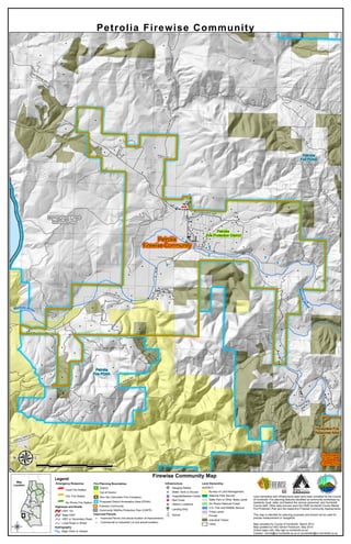
This map shows fire protection resources and infrastructure for the Petrolia area in Humboldt County, California. It identifies the locations of fire stations, highways, rivers, fire planning boundaries, improved parcels, infrastructure like water tanks and schools, and land ownership including private, state, and federal lands. The map was compiled by Humboldt County and updated in 2015 to assist with fire planning and protection in the Petrolia region, and identifies the Petrolia Firewise Community and proposed annexation areas for the Petrolia Fire Protection District.

Recommended
More Related Content
More from Jerry Dinzes
More from Jerry Dinzes (20)
Recently uploaded
Recently uploaded (20)
Firewise Map Petrolia
- 1. Legend Emergency Response ¤ Local Fire Station ¤ CAL Fire Station ¤ Six Rivers Fire Station Highways and Roads HWY 101 State HWY HWY or Secondary Road Local Road or Street Hydrography Major River or Stream Fire Planning Boundaries District Out of District Non-Tax (Volunteer Fire Company) Proposed District Annexation Area (PDAA) Firewise Community Community Wildfire Protection Plan (CWPP) Improved Parcels " Improved Parcel (not actual location of improvement) " Commercial or Industrial Lot (not actual location) Infrastructure > Gauging Station ! Water Tank or Source ®v Hospital/Medical Center G Red Cross [e Historic Locations p Landing Strip ¹½ School Land Ownership AGENCY Bureau of Land Management National Park Service State Park or Other State Lands Six Rivers National Forest U.S. Fish and Wildlife Service Tribal Lands Private Industrial Timber Cities HUMBOLDT COUNTY Map Location : ¹½ ¹½ ¹½Mattole-Lost Coast Planning Unit Petrolia Fire Protection District Honeydew Fire Response Area Petrolia Fire PDAA Petrolia Fire PDAA Honeydew Firewise Community Petrolia Firewise Community MattoleRd Johnny Jack-Hi Rd RiverRd Lighthouse Rd Prosper Ridge Rd LincolnSt Greenfir Rd Walnut Dr ConklinCree k Rd Evergreen W ay ClarkeRd Chambers Rd WalkerDr Old Mattole Rd HornbackRd Smiths Rd MillCreekRd NorthForkRd CooskieRidgeRd Bea rCreekRd Edmonston Rd Boots Can yon Rd The Peak Rd Bo ots Rd Mattole River MattoleRiver 1:40,000RF 0 0.5 1 1.50.25 Miles Firewise Community Map µ Petrolia Firewise Community Land ownership and infrastructure data have been compiled by the County of Humboldt. Fire planning features identified at community workshops by residents; local, state, and federal fire service personnel; and Humboldt County staff. Other data sources were the 2006 Humboldt County Master Fire Protection Plan and the respective Firewise Community Assessments. This map is intended for planning purposes and should not be used for precise measurement or navigation. Map compiled by County of Humboldt, March 2013. Map updated by HSU Senior Practicum. May 2015. Online maps visit: http://gis.co.humboldt.ca.us/ Contact: cimmit@co.humboldt.ca.us or jvondohlen@co.humboldt.ca.us