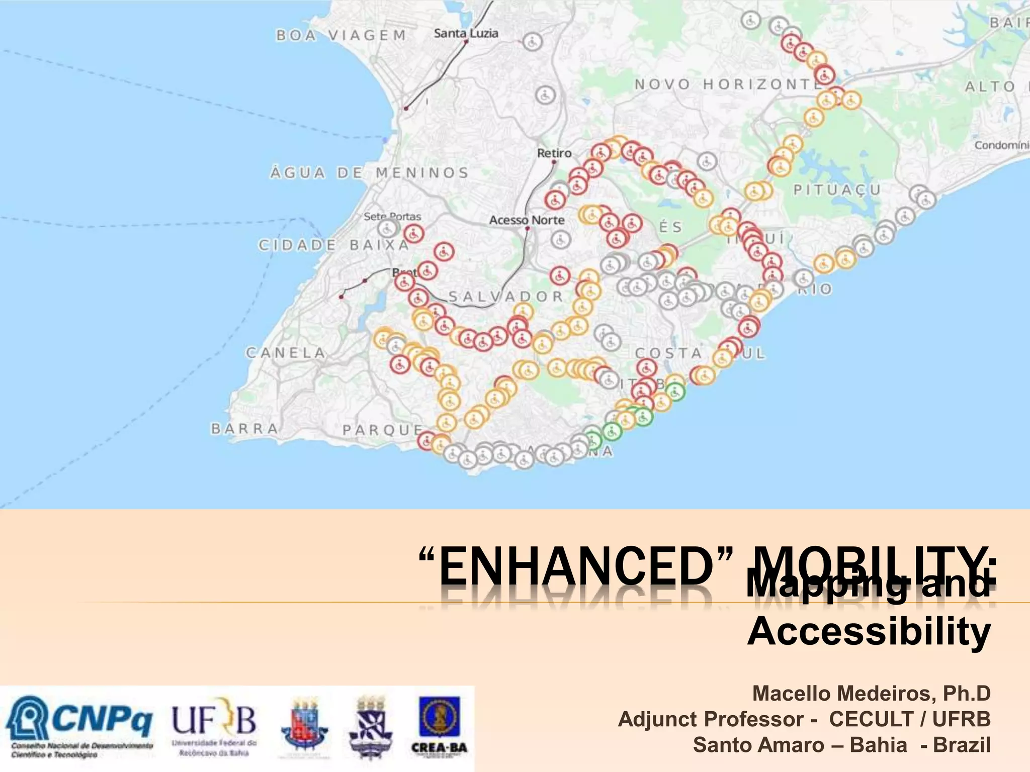
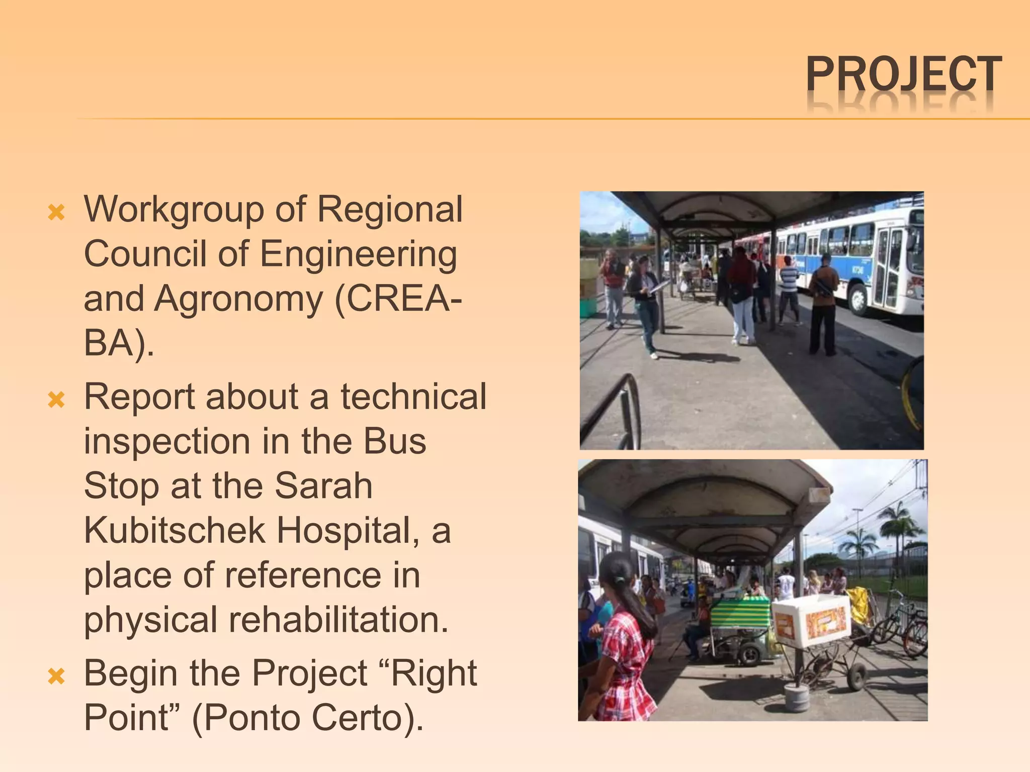
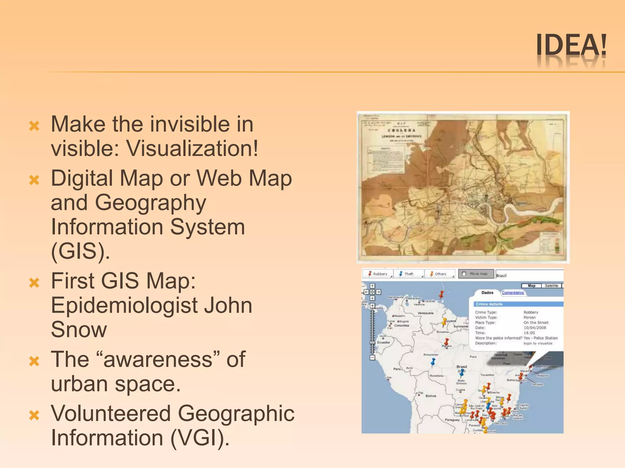
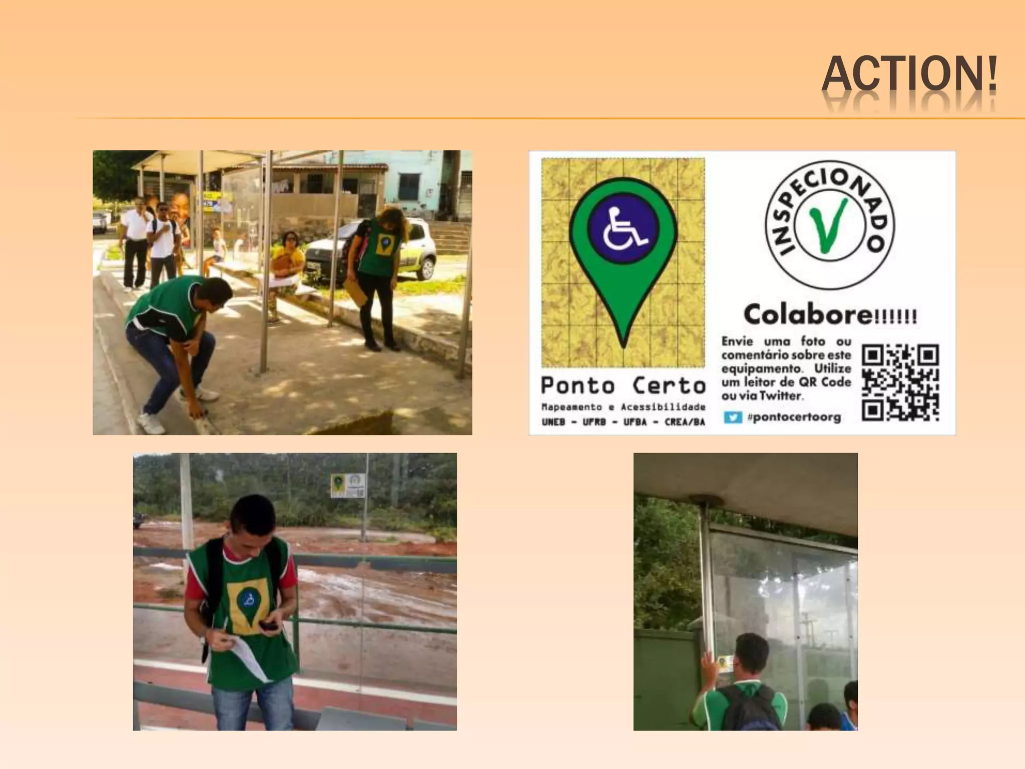
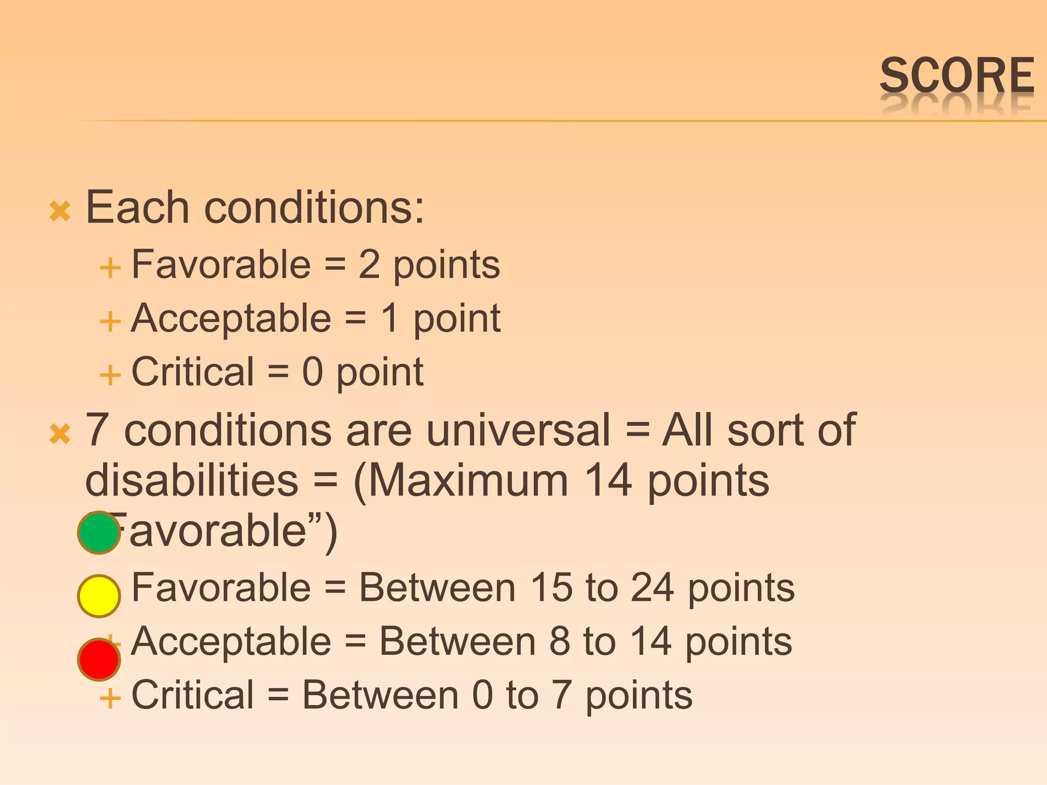
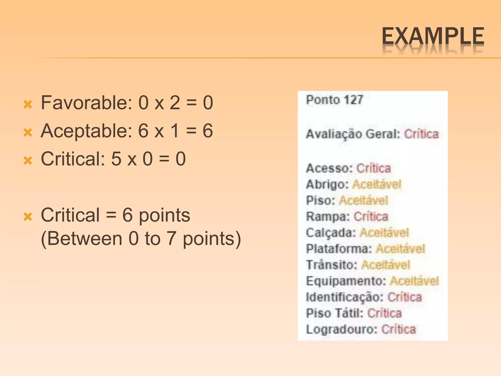
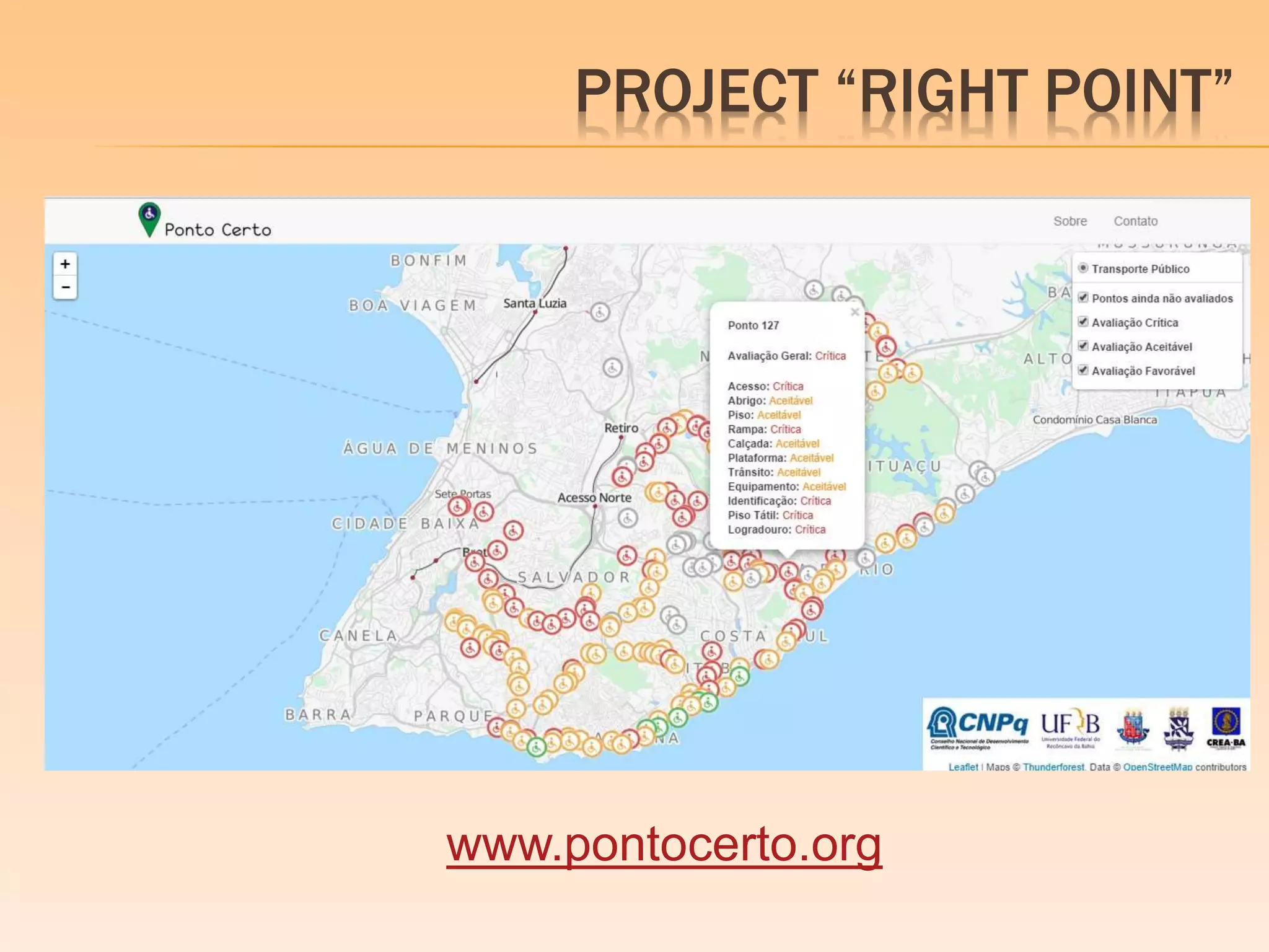
“ENHANCED” MOBILITY: 
Mapping and 
Accessibility 
Macello Medeiros, Ph.D 
Adjunct Professor - CECULT / UFRB 
Santo Amaro – Bahia - Brazil
SITUATION
PROJECT 
 Workgroup of Regional 
Council of Engineering 
and Agronomy (CREA-BA). 
 Report about a technical 
inspection in the Bus 
Stop at the Sarah 
Kubitschek Hospital, a 
place of reference in 
physical rehabilitation. 
 Begin the Project “Right 
Point” (Ponto Certo).
BASIS 
 Law 12.587/2012 - National Policy on Urban 
Mobility 
 Norm ABNT NBR 9050 (Brazilian Association of 
Technical Norms). 
 “The City is a mediation among mediations”, 
“Urban Strategy” and “Near Order / Fat Order” - 
Henri Lefebvre (1996) in “The Right of the City”. 
 “The Right to the Open City” – Rob Shields 
(2013)
IDEA! 
 Make the invisible in 
visible: Visualization! 
 Digital Map or Web Map 
and Geography 
Information System 
(GIS). 
 First GIS Map: 
Epidemiologist John 
Snow 
 The “awareness” of 
urban space. 
 Volunteered Geographic 
Information (VGI).
OBJECTIVES PROJECT 
 Primary 
 Producing a digital map of georeferenced bus stops, using 
GIS with information about the accessibility conditions based 
on specialized technical inspections. 
 Secundary 
 Mapping the bus stop within a radius of 6 km from the Sarah 
Kubitschek hospital in Salvador, identifying its coordinates of 
latitude and longitude. 
 Doing technical inspections based on a form with 12 
conditions of accessibility and assess as critical, acceptable 
and favorable. 
 Georrefering the conditions of accessibility in a web map and 
generating a classification of the bus stops as critical, 
acceptable and favorable. 
 Showing these results by colored markers in the map: red – 
critical; yellow – acceptable and green – favorable.
METODOLOGY 
 Open Street Map (OSM) Data and Google 
Transit Data = 215 Bus Stop. 
 A form with 12 accessibility conditions. 
 Training the students staff by the experts 
from CREA-BA. 
Work in the field between August 1st to 
November 1st, collecting data by inspections. 
 A collaborative action with stickers: 
engagement
ACTION!
WORKING IN PROGRESS 
 194 inspected and georeferenced bus stop 
(already included in the base system). 
 Classification by colred makers. 
 Favorable 
 Acceptable 
 Critical 
 Pop-up with the resume of conditions.
SCORE 
 Each conditions: 
 Favorable = 2 points 
 Acceptable = 1 point 
 Critical = 0 point 
 7 conditions are universal = All sort of 
disabilities = (Maximum 14 points 
“Favorable”) 
 Favorable = Between 15 to 24 points 
 Acceptable = Between 8 to 14 points 
 Critical = Between 0 to 7 points
EXAMPLE 
 Favorable: 0 x 2 = 0 
 Aceptable: 6 x 1 = 6 
 Critical: 5 x 0 = 0 
 Critical = 6 points 
(Between 0 to 7 points)
PROJECT “RIGHT POINT” 
www.pontocerto.org
THANK YOU! 
macellomedeiros@gmail.com 
@macellomedeiros

Enhanced Mobility

  • 1.
    “ENHANCED” MOBILITY: Mappingand Accessibility Macello Medeiros, Ph.D Adjunct Professor - CECULT / UFRB Santo Amaro – Bahia - Brazil
  • 2.
  • 3.
    PROJECT  Workgroupof Regional Council of Engineering and Agronomy (CREA-BA).  Report about a technical inspection in the Bus Stop at the Sarah Kubitschek Hospital, a place of reference in physical rehabilitation.  Begin the Project “Right Point” (Ponto Certo).
  • 4.
    BASIS  Law12.587/2012 - National Policy on Urban Mobility  Norm ABNT NBR 9050 (Brazilian Association of Technical Norms).  “The City is a mediation among mediations”, “Urban Strategy” and “Near Order / Fat Order” - Henri Lefebvre (1996) in “The Right of the City”.  “The Right to the Open City” – Rob Shields (2013)
  • 5.
    IDEA!  Makethe invisible in visible: Visualization!  Digital Map or Web Map and Geography Information System (GIS).  First GIS Map: Epidemiologist John Snow  The “awareness” of urban space.  Volunteered Geographic Information (VGI).
  • 6.
    OBJECTIVES PROJECT Primary  Producing a digital map of georeferenced bus stops, using GIS with information about the accessibility conditions based on specialized technical inspections.  Secundary  Mapping the bus stop within a radius of 6 km from the Sarah Kubitschek hospital in Salvador, identifying its coordinates of latitude and longitude.  Doing technical inspections based on a form with 12 conditions of accessibility and assess as critical, acceptable and favorable.  Georrefering the conditions of accessibility in a web map and generating a classification of the bus stops as critical, acceptable and favorable.  Showing these results by colored markers in the map: red – critical; yellow – acceptable and green – favorable.
  • 7.
    METODOLOGY  OpenStreet Map (OSM) Data and Google Transit Data = 215 Bus Stop.  A form with 12 accessibility conditions.  Training the students staff by the experts from CREA-BA. Work in the field between August 1st to November 1st, collecting data by inspections.  A collaborative action with stickers: engagement
  • 8.
  • 9.
    WORKING IN PROGRESS  194 inspected and georeferenced bus stop (already included in the base system).  Classification by colred makers.  Favorable  Acceptable  Critical  Pop-up with the resume of conditions.
  • 10.
    SCORE  Eachconditions:  Favorable = 2 points  Acceptable = 1 point  Critical = 0 point  7 conditions are universal = All sort of disabilities = (Maximum 14 points “Favorable”)  Favorable = Between 15 to 24 points  Acceptable = Between 8 to 14 points  Critical = Between 0 to 7 points
  • 11.
    EXAMPLE  Favorable:0 x 2 = 0  Aceptable: 6 x 1 = 6  Critical: 5 x 0 = 0  Critical = 6 points (Between 0 to 7 points)
  • 12.
    PROJECT “RIGHT POINT” www.pontocerto.org
  • 13.

Editor's Notes

  • #2 HI, MY NAME IS MACELLO MEDEIROS. I’M FROM SALVADOR, BAHIA, BRASIL. IT’S A PLEASURE TO BE HERE IN CHILE FOR THE FIRST TIME AND FOR A GOOD REASON. I THINK THIS IS AN EVENT EXTREMELY NECESSARY FOR THE UNDERSTANDING OF THE CITY, THE URBAN SPACE AND ITS INHABITANTS. MY PRESENTATION IS CALLED “ENHANCED” MOBILITY: MAPPING AND ACCESSIBILITY. MY PROPOSAL IS TO PRESENT A PROJECT THAT BEST REPRESENTS WHAT I'M CALLING OF "ENHANCED“ MOBILITY. THE PROJECT “RIGHT POINT” HAS A FINANCIAL SUPPORT OF CNPQ, A BRAZILIAN AGENCY FOR RESEARCH DEVELOPMENT.
  • #3 THESE PHOTOS FROM SALVADOR SHOW SOME SITUATIONS THAT THE PERSON WITH DISABILITIES CAN CONFRONT DURING A SIMPLE WALK THROUGH THE CITY. A LOT OF OBSTACLES (PHYSICAL OR NOT) AND INDIFFERENCE IN THE WAY. WE CAN THINK THAT THERE'S NO SENSIBILITY OR AWARENESS ABOUT THE USE OF URBAN SPACE.
  • #4 THESE ISSUES ARE THE CENTRAL POINT IN THE DISCUSSIONS OF THE WORKGROUP IN THE COUNCIL OF ENGINEERING AND AGRONOMY (CREA-BA) THAT I PARTICIPATE AS MEMBER SINCE SEPTEMBER, 2013. ONE OF THE COUNCIL’S TASKS IN LAST YEAR WAS THE INSPECTION OF BUS STOP IN SALVADOR. THE FIRST INSPECTION WAS MADE IN THE SARAH KUBITSCHEK HOSPITAL, A PLACE OF REFERENCE IN PHYSICAL REHABILITATION. AFTER THIS, A REPORT WAS PRODUCED AND SENT TO PUBLIC ADMINISTRATION. THIS REPORT WAS THE BEGINNING OF THE PROJECT “RIGHT POINT”.
  • #5 THIS PROJECT WAS BASED IN TWO PILLARS: JURIDICAL AND THEORIC WITH A INTRINSEC RELATIONSHIP, IN MY POINT VIEW. IN BRAZIL, A LAW DEALS IN ITS CHAPTER III, THE “USER RIGHTS”, WITH THE RIGHT TO INFORMATION IN DIFFERENT WAYS AND A NORM THAT DEALS WITH ISSUES OF ACCESSIBILITY TO BUILDINGS, EQUIPMENT AND URBAN SPACES AS WIDTH OF SIDEWALKS, ACCESS RAMPS AND REGULATIONS, INSTALLATION OF TACTILE FLOOR, ETC. THE THEORIC PILLAR IS BASED IN CONCEPTS OF HENRI LEFEBVRE (1996) LIKE THE “URBAN STRATEGY” THAT SAYS “ONLY GROUPS, SOCIAL CLASSES, AND CLASS FRACTIONS CAPABLE OF REVOLUTIONARY INIATIVE CAN TAKE OVER AND REALIZE TO FRUITIION SOLUTIONS TO URBAN PROBLEMS”. ANOTHER CONCEPT, MORE RECENTLY, IS ABOUT THE “RIGHT TO THE OPEN CITY” BY ROB SHIELDS (2013) THAT SAYS “A RIGHT TO THE CITY ENFRACHISES A NEW CITIZEN, WHO IS NOT SIMPLY A USER OF THE CITY BUT A PARTICIPANT IN ITS CREATION AND INTERPRETATION”.
  • #6 SO, OUR IDEA TO CONTRIBUTE IN THIS CREATION AND INTERPRETATION OF THE CITY IS MAKE VISIBLE THESE ISSUES THAT ARE INVISIBLE TO THE MOST OF PEOPLE. THROUGH A WEB MAP, WE DECIDE TO USE THE GEOGRAPHIC INFORMATION SYSTEM TO “MAKE VISIBLE” THE CONDITION OF ACCESSIBILITY IN BUS STOP. THIS IS NOT A ORIGINAL IDEA. THE FIRST IS MAP WAS PRODUCED BY THE EPIDEMIOLOGIST, JOHN SNOW, TO TRACING THE SOURCE OF A CHOLERA OUTBREAK IN SOHO, LONDON, IN 1854. OUR AIM WITH THIS INITIATIVE IS GET THE “AWARENESS” OF URBAN SPACE, IN SPECIFIC WAY, THE ISSUES OF MOBILITY AND ACCESSIBILITY. THIS PROJECT CAN BE CONSIDERED AS A VGI PROJECT BECAUSE OF THESE CHARACTERISTICS.
  • #7 PRIMARY: PRODUCING A DIGITAL MAP OF GEOREFERENCED BUS STOP, USING GIS WITH INFORMATION ABOUT THE ACCESSIBILITY CONDITIONS BASED ON SPECIALIZED TECHNICAL INSPECTIONS. SECUNDARY MAPPING THE BUS STOP WITHIN A RADIUS OF 6 KM FROM THE SARAH KUBITSCHEK HOSPITAL IN SALVADOR, IDENTIFYING ITS COORDINATES OF LATITUDE AND LONGITUDE. DOING TECHNICAL INSPECTIONS BASED ON A FORM WITH 12 CONDITIONS OF ACCESSIBILITY AND ASSESS AS CRITICAL, ACCEPTABLE AND FAVORABLE. GEORREFERING THESE RESULTS IN A WEB MAP AND GENERATING A CLASSIFICATION OF THE BUS STOPS AS CRITICAL, ACCEPTABLE AND FAVORABLE. SHOWING THESE RESULTS BY COLORED MARKERS IN THE MAP: RED – CRITICAL; YELLOW – ACCEPTABLE AND GREEN – FAVORABLE.
  • #8 INITIALLY, WE USED A INCOMPLETE DATABASE OF OPEN STREET MAP (OSM) AND IT WAS COMPLEMENTED WITH THE GOOGLE TRANSIT DATABASE TOTALING 215 BUS STOPS. AFTER, WE PRODUCED A FORM WITH 12 ACCESSIBILITY CONDITIONS (USING THE REPORT AS SUPPORT) AND APPLIED IN THE BUS STOP OF SARAH HOSPITAL WITH THE SUPERVISION OF EXPERTS FROM CREA-BA (ENGINEERS, ARCHITECTS, URBANISTS). THE STUDENTS BEGAN THE INSPECTIONS OF BUS STOPS, APPLYING THE FORM FROM AUGUST, 1st. AND THEY WILL PROBABLY FINISH IN NOVEMBER, 1st. FURTHERMORE, A COLLABORATIVE ACTION WAS IMPLEMENTED USING STICKERS IN BUS STOP TO ENGAGE THE USERS.
  • #9 SOME PHOTOS OF THE STUDENTS IN THE FIELD AND THE STICKERS USED TO ENGAGE THE PEOPLE IN THE PROJECT. “RIGHT POINT’” “INSPECTED / EXAMINED” “COLLABORATE!” “SENT A PHOTO OR A COMMENT ABOUT THIS EQUIPMENT. USE THE QR CODE READER OR TWITTER”
  • #10 FINALLY, AT THE MOMENT, WE ARE IN THE LAST STAGE OF THE PROJECT AND OUR PROBABLY DATE TO FINISH IS NOVEMBER 1ST. UNTIL NOW, WE CONCLUDED THE INSPECTION AND GEOREFERENCING OF ONE HUNDRED AND NINETY FOUR BUS STOPS, CLASSIFIED BY COLORED MARKERS. IN EACH POINT, WE PROVIDE A SUMMARY OF THE CONDITIONS VERIFIED IN THE INSPECTION.
  • #11 FINALLY, AT THE MOMENT, WE ARE IN THE LAST STAGE OF THE PROJECT AND OUR PROBABLY DATE TO FINISH IS NOVEMBER 1ST. UNTIL NOW, WE CONCLUDED THE INSPECTION AND GEOREFERENCING OF ONE HUNDRED AND NINETY FOUR BUS STOPS, CLASSIFIED BY COLORED MARKERS. IN EACH POINT, WE PROVIDE A SUMMARY OF THE CONDITIONS VERIFIED IN THE INSPECTION.
  • #13 “ACCESS” “COVERAGE” “FLOOR” “RAMPS” “SIDEWALK” “ETC.”