Ed. Secundaria. Alberto Lanzat. CI para las áreas no lingüísticas de Ed. Secundaria.
•Download as PPT, PDF•
0 likes•341 views
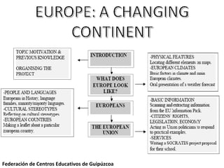
This document outlines a 12-step sequential map for a unit on locating places in Europe, identifying EU members, and analyzing European weather forecasts. The unit includes locating places on maps, multiple choice questions about European countries, categorizing famous Europeans, identifying physical features on maps of Europe, running dictations to mark locations, information gaps about climate factors, matching climate descriptions to graphs, listening to and checking weather forecasts, writing forecasts for European regions, reflecting on predictions, and presenting a weather forecast for a European region.
Report
Share
Report
Share

Recommended
Rosa Benavides. Particulariddaes de los cursos CALL. Planteamientos didáctico...
Este documento presenta las características y necesidades del alumnado de los Cursos de Actualización Lingüística (CAL), así como los enfoques didácticos y metodológicos para adaptar los cursos a sus necesidades. Se discuten cuestiones como el perfil del alumnado CAL, las adaptaciones curriculares requeridas, y ejemplos de actividades y recursos apropiados para este tipo de cursos. Finalmente, se plantean preguntas para un debate sobre los retos y mejores prácticas para la enseñanza en los curs
Flor
Una mujer rica tenía todo lo que podía desear, pero estaba tan ocupada con el trabajo y las responsabilidades que descuidaba a su familia. Su padre sabio le dio una flor única y le dijo que la cuidara, pero ella también la descuidó y la flor murió. Su padre le explicó que su familia, al igual que la flor, necesitaba de su atención y cuidado para no marchitarse.
NEW MEDIA
The document discusses perspectives on how smartphones contribute to increased mobility and miniaturization in society. It notes that while technologies may be accepted, their use is not guaranteed to match intentions. Smartphones keep users connected through physical and social networks, empowering users while potentially disconnecting them from others or serving as a distraction. Games are a major smartphone feature, both basic and downloadable games, though they can imply temporary experiences. Smartphones bring together the symbolic and physical worlds through simulations controlled by buttons. Expert knowledge is required to fully utilize smartphones, and costs may prohibit some from purchasing devices.
Breaking Into P R 11 7 07
The document provides tips for breaking into the competitive field of public relations (PR) and securing a job in that industry. It discusses keys to success like internships and extracurricular activities in school, how to conduct an effective job search and interview process, and things to consider when interviewing like being prepared, selling your strengths, asking questions, and making a good first impression. The document emphasizes the importance of preparation, researching the company and interviewer, having a positive attitude, and viewing the interview as an opportunity to assess fit on both sides.
Yolanda Ramírez Campos. EEOOII. Buenas prácticas en una Educación Plurilingüe...
El documento habla sobre la necesidad de mejorar la enseñanza de idiomas mediante métodos más efectivos y duraderos. Propone usar explicaciones más sencillas y adaptadas a diferentes estilos de aprendizaje, así como actividades creativas y entretenidas que motiven a los estudiantes y activen su memoria a largo plazo. También sugiere usar la lengua materna como herramienta, ser muy visual y aprovechar la música, la imaginación y sugerencias de los estudiantes.
E. Secundaria. Antonio Roldán. Buenas Prácticas en una educación plul
Este documento describe las buenas prácticas en una educación plurilingüe. Define buenas prácticas como iniciativas adoptadas para favorecer el desarrollo del plurilingüismo. Explica que las buenas prácticas surgen de una práctica bien informada y de una formación reflexiva. Además, identifica tres fases del proceso de aprendizaje de lenguas - exposición, asimilación y producción - y los tipos de tareas apropiadas para cada fase.
D
The document summarizes key events and people in the Space Race between the US and USSR from 1957 to 1975. It describes how the Soviet Union launched Sputnik 1 in 1957, the first artificial satellite, starting fears in the US that the Soviets could launch nuclear missiles. Important early milestones included Yuri Gagarin becoming the first person to orbit Earth in 1961, and the US launching Alan Shepard as the first American in space. The document outlines further satellite and human launches by both countries leading up to the historic Apollo 11 mission in 1969, when Neil Armstrong became the first person to walk on the moon.
Etwinning y Programas Educativos Europeos
El documento proporciona información sobre el programa eTwinning y los Programas Educativos Europeos. eTwinning promueve el contacto y colaboración entre profesores y estudiantes a través de las TIC. Los Programas Educativos Europeos como Comenius, Erasmus, Leonardo da Vinci y Grundtvig permiten conocer otras realidades educativas europeas, mejorar las competencias lingüísticas y aprender unos de otros. El documento describe acciones como asociaciones escolares, proyectos multilaterales, formación continua y movilidad de estudiantes.
¿Cómo elaborar un proyecto para una asociación Comenius?
Este documento proporciona información sobre cómo elaborar un proyecto europeo para una asociación escolar, incluyendo detalles sobre la documentación requerida, criterios de evaluación, contenido del proyecto, implementación y participantes. Explica el proceso de solicitud para asociaciones escolares Comenius y Leonardo da Vinci, con enfoque en los requisitos, financiación disponible y cómo maximizar la probabilidad de aprobación.
Guía informativa centros modalidad bilingüe
Este documento presenta una guía informativa para centros educativos con modalidad de enseñanza bilingüe en Andalucía. Explica los objetivos de fomentar el plurilingüismo y la competencia lingüística en inglés y otras lenguas. Incluye información sobre la coordinación, el profesorado, los auxiliares de conversación, la metodología AICLE, y recursos y programas para apoyar la enseñanza bilingüe. La guía pretende orientar a los agentes implicados y proporcionar ejemp
Victor Pavon.Modelos de Unidades Didácticas Integradas
Este documento presenta modelos de unidades didácticas integradas para el Currículo Integrado de las Lenguas. Propone una estructura curricular coordinada e integrada que incluye sugerencias metodológicas y pautas para el diseño de materiales. Además, ofrece ejemplos de secuencias didácticas que integran las tres lenguas de manera innovadora y basada en tareas, con un enfoque en la interacción, la selección de materiales y la atención a la forma a través de la comunicación.
Maria Maeso.Presentacion CIL
El documento describe los orígenes e implementación del currículo integrado de lenguas en Andalucía, basado en el Marco Común Europeo de Referencia para las Lenguas. Explica cómo los decretos andaluces de educación primaria y secundaria establecen las competencias lingüísticas y horas de enseñanza de lengua castellana, primera y segunda lengua extranjera de forma integrada. El objetivo es desarrollar las cuatro habilidades lingüísticas básicas en todas las lenguas de forma funcional e inter
Fernando Trujillo
Este documento propone la elaboración de un Proyecto Lingüístico de Centro para promover el plurilingüismo. El proyecto debería incluir actuaciones como un currículo integrado de lenguas, la integración de lenguas y contenidos, atención a la diversidad lingüística y planes de mejora. Estas actuaciones ayudarían a los estudiantes a desarrollar mejor su competencia comunicativa en varias lenguas a través del uso de éstas en contextos reales y significativos.
Henar López. Taller CIL Secundaria
Este documento presenta una propuesta de integración curricular para las lenguas en educación secundaria obligatoria. Propone un enfoque comunicativo y contextualizado centrado en el desarrollo de las habilidades lingüísticas a través de tareas. El castellano serviría como eje del currículo integrado, abordando contenidos gramaticales de forma pragmática y funcional mediante actividades que implican la observación, análisis y producción de distintos géneros textuales. La evaluación se basaría en criterios como la autoevaluación y
Cil.Taller Primaria.Ramon Martín Y M.Ángeles Hernández
Este documento describe los elementos clave de una unidad didáctica integrada de lenguas. Explica la diferencia entre CLIL y currículo integrado de lenguas, y los beneficios de un enfoque integrado. Además, detalla los pasos para diseñar una unidad integrada, incluyendo la selección de un tema central, el diseño de una tarea final, y la planificación de tareas intermedias y objetivos de aprendizaje.
Programas Europeos
Este documento describe los diferentes tipos de programas europeos educativos disponibles, incluyendo proyectos multilaterales y bilaterales que permiten la colaboración entre escuelas, programas de movilidad para estudiantes, ayudantes de conversación, y oportunidades de formación para maestros y líderes escolares. Los programas europeos ayudan a mejorar las habilidades lingüísticas, aprender de las prácticas educativas de otros países, y fomentar la cooperación internacional.
Presentacion Cep Huelvalineasprioritariasplurilinguismo
El documento presenta el plan de apoyo a los nuevos centros bilingües en la provincia de Huelva, incluyendo sesiones de formación inicial para los equipos directivos y profesorado, formación específica sobre la enseñanza bilingüe y el uso de recursos en lenguas extranjeras, y el seguimiento de grupos de trabajo transversales para compartir experiencias y materiales. También se detallan las acciones para difundir el currículo integrado de lenguas y promover la participación en programas europeos.
Organizacioncentrosbilinguesnuevos.Sept09
El documento describe los aspectos básicos de organización y funcionamiento de los centros bilingües en Andalucía, incluyendo los horarios de lengua extranjera para primaria y secundaria, los compromisos del centro, el reconocimiento al coordinador y profesorado, el seguimiento del proyecto y las funciones y abono de las ayudas de los auxiliares de conversación.
Polish educational system
The educational system in Poland underwent reforms in 1998/1999 that changed administration, financing, and teachers' rights and duties. Education is now compulsory from ages 7 to 18, though alternatives exist after 16 like apprenticeships. Pre-school education for ages 6 is also mandatory to stimulate development. Elementary school is for ages 7-12, with primary education divided into early learning and systematic learning cycles. Students then choose between general secondary schools, vocational schools, or post-secondary education to become qualified workers or continue to university. Public schools are free while non-public schools can charge fees.
Italian educational system I
The document summarizes key information about the Italian education system. It provides statistics on student enrollment, state schools, and teachers. It describes the structure of education from pre-primary to higher education. Primary school is for ages 6-11 and compulsory. Secondary education has two stages, with the first from ages 11-14. Upper secondary offers both vocational and academic paths. Special support is provided for disabled students integrated into mainstream schools. The document also summarizes a specific lower secondary school in Chiavari, including enrollment numbers, facilities, courses, and projects.
Italian educational system
This document provides information about two middle schools in Livorno, Italy: Scuola media "Borsi-Pazzini". It describes that the schools have students aged 11-13 divided into three levels and multiple classes. It shares details about the classrooms of students Elena from the 1st N class at Pazzini School and the 2nd G class at Borsi School, including photos of the buildings and classrooms. The document aims to introduce the schools and some of their students.
Irene Vella: Malta´s educational system
The document summarizes key aspects of the education system in Malta and Gozo. There are state and church primary and secondary schools. Support is provided through peripatetic teachers in literacy, ICT, science, art and other subjects. Students have exams starting in year 4, and the 11+ exam determines secondary school placement. Streaming exists in later primary and secondary years. Adult education and family literacy programs are also offered.
Neil Gibbons presentation. Welsh educational System
This document provides information about education in Wales and the experiences a child named Megan might have growing up in the Welsh education system. It outlines the stages of education from ages 0-7, 7-11, 11-14, 14-16, and 16-19. It also discusses reforms being implemented, including a skills-based curriculum, teacher assessments, and increased vocational options. Flintshire Local Education Authority and the schools in its area are highlighted.
The Andalusian School System
The document summarizes the education system in Andalusia, Spain. It describes the structure of the education system from pre-school through university level. It also discusses compulsory education requirements, secondary education subjects, vocational training options after compulsory education, and adult education programs. The system places an emphasis on developing basic competencies and skills in students based on European Union guidelines.
Ed. Infantil y Primaria.Rosario León. Implantación del Proyecto Bilingüe.
El documento describe el Plan de Fomento del Plurilingüismo de la Junta de Andalucía, el cual promueve la enseñanza bilingüe en las escuelas. Se presenta un calendario de aplicación progresiva del plan durante 6-7 años, comenzando con la sensibilización del idioma extranjero en educación infantil y ampliando su enseñanza en más cursos y áreas con el tiempo. También se detalla la formación lingüística y didáctica que se ofrece al profesorado para implementar con éxito el modelo
Ed. Infantil y Primaria. Inmaculada Fernández. Portfolio. Parte III
El documento describe las actividades realizadas en una clase de francés durante enero y febrero. Incluye cuentos, música, teatro y visitas a otras escuelas para intercambiar actuaciones. También describe proyectos como la creación de un portafolio y la celebración de la Semana de las Lenguas. Finalmente, enumera descriptores y objetivos de aprendizaje en diferentes habilidades lingüísticas como la escritura, lectura, conversación, comprensión oral y expresión oral.
Ed.Infantil y Primaria. Parte II. Inmaculada Fernández. Implementación del Po...
El documento describe el segundo año de implementación de un proyecto bilingüe en una escuela primaria que incluye actividades para celebrar la "Semana de las Lenguas". Se detallan los planes para realizar actividades conjuntas en todas las clases centradas en los niños de diferentes partes del mundo, incluyendo cuentacuentos, teatro y una exposición con materiales recopilados.
Ed. Infantil y Primaria. Inmaculada Arévalo. Parte I. Implantación del Portfo...
El documento describe la implementación de un portafolio en un colegio bilingüe en España durante el año escolar 2005-2006. El objetivo era concienciar a la comunidad educativa sobre la enseñanza bilingüe y el uso de portafolios. Se formaron grupos de trabajo y se llevaron a cabo actividades en las aulas para involucrar a los estudiantes, como una semana de las lenguas y el día del libro, donde los estudiantes trabajaron con el libro "Platero y yo" en español y francés.
Unlocking WhatsApp Marketing with HubSpot: Integrating Messaging into Your Ma...
50 million companies worldwide leverage WhatsApp as a key marketing channel. You may have considered adding it to your marketing mix, or probably already driving impressive conversions with WhatsApp.
But wait. What happens when you fully integrate your WhatsApp campaigns with HubSpot?
That's exactly what we explored in this session.
We take a look at everything that you need to know in order to deploy effective WhatsApp marketing strategies, and integrate it with your buyer journey in HubSpot. From technical requirements to innovative campaign strategies, to advanced campaign reporting - we discuss all that and more, to leverage WhatsApp for maximum impact. Check out more details about the event here https://events.hubspot.com/events/details/hubspot-new-delhi-presents-unlocking-whatsapp-marketing-with-hubspot-integrating-messaging-into-your-marketing-strategy/
Pro Tips for Effortless Contract Management
Tired of chasing down expiring contracts and drowning in paperwork? Mastering contract management can significantly enhance your business efficiency and productivity. This guide unveils expert secrets to streamline your contract management process. Learn how to save time, minimize risk, and achieve effortless contract management.
More Related Content
More from mluisao
¿Cómo elaborar un proyecto para una asociación Comenius?
Este documento proporciona información sobre cómo elaborar un proyecto europeo para una asociación escolar, incluyendo detalles sobre la documentación requerida, criterios de evaluación, contenido del proyecto, implementación y participantes. Explica el proceso de solicitud para asociaciones escolares Comenius y Leonardo da Vinci, con enfoque en los requisitos, financiación disponible y cómo maximizar la probabilidad de aprobación.
Guía informativa centros modalidad bilingüe
Este documento presenta una guía informativa para centros educativos con modalidad de enseñanza bilingüe en Andalucía. Explica los objetivos de fomentar el plurilingüismo y la competencia lingüística en inglés y otras lenguas. Incluye información sobre la coordinación, el profesorado, los auxiliares de conversación, la metodología AICLE, y recursos y programas para apoyar la enseñanza bilingüe. La guía pretende orientar a los agentes implicados y proporcionar ejemp
Victor Pavon.Modelos de Unidades Didácticas Integradas
Este documento presenta modelos de unidades didácticas integradas para el Currículo Integrado de las Lenguas. Propone una estructura curricular coordinada e integrada que incluye sugerencias metodológicas y pautas para el diseño de materiales. Además, ofrece ejemplos de secuencias didácticas que integran las tres lenguas de manera innovadora y basada en tareas, con un enfoque en la interacción, la selección de materiales y la atención a la forma a través de la comunicación.
Maria Maeso.Presentacion CIL
El documento describe los orígenes e implementación del currículo integrado de lenguas en Andalucía, basado en el Marco Común Europeo de Referencia para las Lenguas. Explica cómo los decretos andaluces de educación primaria y secundaria establecen las competencias lingüísticas y horas de enseñanza de lengua castellana, primera y segunda lengua extranjera de forma integrada. El objetivo es desarrollar las cuatro habilidades lingüísticas básicas en todas las lenguas de forma funcional e inter
Fernando Trujillo
Este documento propone la elaboración de un Proyecto Lingüístico de Centro para promover el plurilingüismo. El proyecto debería incluir actuaciones como un currículo integrado de lenguas, la integración de lenguas y contenidos, atención a la diversidad lingüística y planes de mejora. Estas actuaciones ayudarían a los estudiantes a desarrollar mejor su competencia comunicativa en varias lenguas a través del uso de éstas en contextos reales y significativos.
Henar López. Taller CIL Secundaria
Este documento presenta una propuesta de integración curricular para las lenguas en educación secundaria obligatoria. Propone un enfoque comunicativo y contextualizado centrado en el desarrollo de las habilidades lingüísticas a través de tareas. El castellano serviría como eje del currículo integrado, abordando contenidos gramaticales de forma pragmática y funcional mediante actividades que implican la observación, análisis y producción de distintos géneros textuales. La evaluación se basaría en criterios como la autoevaluación y
Cil.Taller Primaria.Ramon Martín Y M.Ángeles Hernández
Este documento describe los elementos clave de una unidad didáctica integrada de lenguas. Explica la diferencia entre CLIL y currículo integrado de lenguas, y los beneficios de un enfoque integrado. Además, detalla los pasos para diseñar una unidad integrada, incluyendo la selección de un tema central, el diseño de una tarea final, y la planificación de tareas intermedias y objetivos de aprendizaje.
Programas Europeos
Este documento describe los diferentes tipos de programas europeos educativos disponibles, incluyendo proyectos multilaterales y bilaterales que permiten la colaboración entre escuelas, programas de movilidad para estudiantes, ayudantes de conversación, y oportunidades de formación para maestros y líderes escolares. Los programas europeos ayudan a mejorar las habilidades lingüísticas, aprender de las prácticas educativas de otros países, y fomentar la cooperación internacional.
Presentacion Cep Huelvalineasprioritariasplurilinguismo
El documento presenta el plan de apoyo a los nuevos centros bilingües en la provincia de Huelva, incluyendo sesiones de formación inicial para los equipos directivos y profesorado, formación específica sobre la enseñanza bilingüe y el uso de recursos en lenguas extranjeras, y el seguimiento de grupos de trabajo transversales para compartir experiencias y materiales. También se detallan las acciones para difundir el currículo integrado de lenguas y promover la participación en programas europeos.
Organizacioncentrosbilinguesnuevos.Sept09
El documento describe los aspectos básicos de organización y funcionamiento de los centros bilingües en Andalucía, incluyendo los horarios de lengua extranjera para primaria y secundaria, los compromisos del centro, el reconocimiento al coordinador y profesorado, el seguimiento del proyecto y las funciones y abono de las ayudas de los auxiliares de conversación.
Polish educational system
The educational system in Poland underwent reforms in 1998/1999 that changed administration, financing, and teachers' rights and duties. Education is now compulsory from ages 7 to 18, though alternatives exist after 16 like apprenticeships. Pre-school education for ages 6 is also mandatory to stimulate development. Elementary school is for ages 7-12, with primary education divided into early learning and systematic learning cycles. Students then choose between general secondary schools, vocational schools, or post-secondary education to become qualified workers or continue to university. Public schools are free while non-public schools can charge fees.
Italian educational system I
The document summarizes key information about the Italian education system. It provides statistics on student enrollment, state schools, and teachers. It describes the structure of education from pre-primary to higher education. Primary school is for ages 6-11 and compulsory. Secondary education has two stages, with the first from ages 11-14. Upper secondary offers both vocational and academic paths. Special support is provided for disabled students integrated into mainstream schools. The document also summarizes a specific lower secondary school in Chiavari, including enrollment numbers, facilities, courses, and projects.
Italian educational system
This document provides information about two middle schools in Livorno, Italy: Scuola media "Borsi-Pazzini". It describes that the schools have students aged 11-13 divided into three levels and multiple classes. It shares details about the classrooms of students Elena from the 1st N class at Pazzini School and the 2nd G class at Borsi School, including photos of the buildings and classrooms. The document aims to introduce the schools and some of their students.
Irene Vella: Malta´s educational system
The document summarizes key aspects of the education system in Malta and Gozo. There are state and church primary and secondary schools. Support is provided through peripatetic teachers in literacy, ICT, science, art and other subjects. Students have exams starting in year 4, and the 11+ exam determines secondary school placement. Streaming exists in later primary and secondary years. Adult education and family literacy programs are also offered.
Neil Gibbons presentation. Welsh educational System
This document provides information about education in Wales and the experiences a child named Megan might have growing up in the Welsh education system. It outlines the stages of education from ages 0-7, 7-11, 11-14, 14-16, and 16-19. It also discusses reforms being implemented, including a skills-based curriculum, teacher assessments, and increased vocational options. Flintshire Local Education Authority and the schools in its area are highlighted.
The Andalusian School System
The document summarizes the education system in Andalusia, Spain. It describes the structure of the education system from pre-school through university level. It also discusses compulsory education requirements, secondary education subjects, vocational training options after compulsory education, and adult education programs. The system places an emphasis on developing basic competencies and skills in students based on European Union guidelines.
Ed. Infantil y Primaria.Rosario León. Implantación del Proyecto Bilingüe.
El documento describe el Plan de Fomento del Plurilingüismo de la Junta de Andalucía, el cual promueve la enseñanza bilingüe en las escuelas. Se presenta un calendario de aplicación progresiva del plan durante 6-7 años, comenzando con la sensibilización del idioma extranjero en educación infantil y ampliando su enseñanza en más cursos y áreas con el tiempo. También se detalla la formación lingüística y didáctica que se ofrece al profesorado para implementar con éxito el modelo
Ed. Infantil y Primaria. Inmaculada Fernández. Portfolio. Parte III
El documento describe las actividades realizadas en una clase de francés durante enero y febrero. Incluye cuentos, música, teatro y visitas a otras escuelas para intercambiar actuaciones. También describe proyectos como la creación de un portafolio y la celebración de la Semana de las Lenguas. Finalmente, enumera descriptores y objetivos de aprendizaje en diferentes habilidades lingüísticas como la escritura, lectura, conversación, comprensión oral y expresión oral.
Ed.Infantil y Primaria. Parte II. Inmaculada Fernández. Implementación del Po...
El documento describe el segundo año de implementación de un proyecto bilingüe en una escuela primaria que incluye actividades para celebrar la "Semana de las Lenguas". Se detallan los planes para realizar actividades conjuntas en todas las clases centradas en los niños de diferentes partes del mundo, incluyendo cuentacuentos, teatro y una exposición con materiales recopilados.
Ed. Infantil y Primaria. Inmaculada Arévalo. Parte I. Implantación del Portfo...
El documento describe la implementación de un portafolio en un colegio bilingüe en España durante el año escolar 2005-2006. El objetivo era concienciar a la comunidad educativa sobre la enseñanza bilingüe y el uso de portafolios. Se formaron grupos de trabajo y se llevaron a cabo actividades en las aulas para involucrar a los estudiantes, como una semana de las lenguas y el día del libro, donde los estudiantes trabajaron con el libro "Platero y yo" en español y francés.
More from mluisao (20)
¿Cómo elaborar un proyecto para una asociación Comenius?
¿Cómo elaborar un proyecto para una asociación Comenius?
Victor Pavon.Modelos de Unidades Didácticas Integradas
Victor Pavon.Modelos de Unidades Didácticas Integradas
Cil.Taller Primaria.Ramon Martín Y M.Ángeles Hernández
Cil.Taller Primaria.Ramon Martín Y M.Ángeles Hernández
Presentacion Cep Huelvalineasprioritariasplurilinguismo
Presentacion Cep Huelvalineasprioritariasplurilinguismo
Neil Gibbons presentation. Welsh educational System
Neil Gibbons presentation. Welsh educational System
Ed. Infantil y Primaria.Rosario León. Implantación del Proyecto Bilingüe.
Ed. Infantil y Primaria.Rosario León. Implantación del Proyecto Bilingüe.
Ed. Infantil y Primaria. Inmaculada Fernández. Portfolio. Parte III
Ed. Infantil y Primaria. Inmaculada Fernández. Portfolio. Parte III
Ed.Infantil y Primaria. Parte II. Inmaculada Fernández. Implementación del Po...
Ed.Infantil y Primaria. Parte II. Inmaculada Fernández. Implementación del Po...
Ed. Infantil y Primaria. Inmaculada Arévalo. Parte I. Implantación del Portfo...
Ed. Infantil y Primaria. Inmaculada Arévalo. Parte I. Implantación del Portfo...
Recently uploaded
Unlocking WhatsApp Marketing with HubSpot: Integrating Messaging into Your Ma...
50 million companies worldwide leverage WhatsApp as a key marketing channel. You may have considered adding it to your marketing mix, or probably already driving impressive conversions with WhatsApp.
But wait. What happens when you fully integrate your WhatsApp campaigns with HubSpot?
That's exactly what we explored in this session.
We take a look at everything that you need to know in order to deploy effective WhatsApp marketing strategies, and integrate it with your buyer journey in HubSpot. From technical requirements to innovative campaign strategies, to advanced campaign reporting - we discuss all that and more, to leverage WhatsApp for maximum impact. Check out more details about the event here https://events.hubspot.com/events/details/hubspot-new-delhi-presents-unlocking-whatsapp-marketing-with-hubspot-integrating-messaging-into-your-marketing-strategy/
Pro Tips for Effortless Contract Management
Tired of chasing down expiring contracts and drowning in paperwork? Mastering contract management can significantly enhance your business efficiency and productivity. This guide unveils expert secrets to streamline your contract management process. Learn how to save time, minimize risk, and achieve effortless contract management.
Satta Matka Dpboss Kalyan Matka Results Kalyan Chart
SATTA MATKA DPBOSS KALYAN MATKA RESULTS KALYAN CHART KALYAN MATKA MATKA RESULT KALYAN MATKA TIPS SATTA MATKA MATKA COM MATKA PANA JODI TODAY BATTA SATKA MATKA PATTI JODI NUMBER MATKA RESULTS MATKA CHART MATKA JODI SATTA COM INDIA SATTA MATKA MATKA TIPS MATKA WAPKA ALL MATKA RESULT LIVE ONLINE MATKA RESULT KALYAN MATKA RESULT DPBOSS MATKA 143 MAIN MATKA KALYAN MATKA RESULTS KALYAN CHART
High-Quality IPTV Monthly Subscription for $15
Experience high-quality entertainment with our IPTV monthly subscription for just $15. Access a vast array of live TV channels, movies, and on-demand shows with crystal-clear streaming. Our reliable service ensures smooth, uninterrupted viewing at an unbeatable price. Perfect for those seeking premium content without breaking the bank. Start streaming today!
https://rb.gy/f409dk
IMG_20240615_091110.pdf dpboss guessing
Satta matka fixx jodi panna all market dpboss matka guessing fixx panna jodi kalyan and all market game liss cover now 420 matka office mumbai maharashtra india fixx jodi panna
Call me 9040963354
WhatsApp 9040963354
Satta Matka Dpboss Kalyan Matka Results Kalyan Chart
SATTA MATKA DPBOSS KALYAN MATKA RESULTS KALYAN CHART KALYAN MATKA MATKA RESULT KALYAN MATKA TIPS SATTA MATKA MATKA COM MATKA PANA JODI TODAY BATTA SATKA MATKA PATTI JODI NUMBER MATKA RESULTS MATKA CHART MATKA JODI SATTA COM INDIA SATTA MATKA MATKA TIPS MATKA WAPKA ALL MATKA RESULT LIVE ONLINE MATKA RESULT KALYAN MATKA RESULT DPBOSS MATKA 143 MAIN MATKA KALYAN MATKA RESULTS KALYAN CHART
Satta Matka Dpboss Kalyan Matka Results Kalyan Chart
SATTA MATKA DPBOSS KALYAN MATKA RESULTS KALYAN CHART KALYAN MATKA MATKA RESULT KALYAN MATKA TIPS SATTA MATKA MATKA COM MATKA PANA JODI TODAY BATTA SATKA MATKA PATTI JODI NUMBER MATKA RESULTS MATKA CHART MATKA JODI SATTA COM INDIA SATTA MATKA MATKA TIPS MATKA WAPKA ALL MATKA RESULT LIVE ONLINE MATKA RESULT KALYAN MATKA RESULT DPBOSS MATKA 143 MAIN MATKA KALYAN MATKA RESULTS KALYAN CHART INDIA MATKA KALYAN SATTA MATKA 420 INDIAN MATKA SATTA KING MATKA FIX JODI FIX FIX FIX SATTA NAMBAR MATKA INDIA SATTA BATTA
Presentation by Herman Kienhuis (Curiosity VC) on Investing in AI for ABS Alu...
Presentation by Herman Kienhuis (Curiosity VC) on developments in AI, the venture capital investment landscape and Curiosity VC's approach to investing, at the alumni event of Amsterdam Business School (University of Amsterdam) on June 13, 2024 in Amsterdam.
Prescriptive analytics BA4206 Anna University PPT
Business analysis - Prescriptive analytics Introduction to Prescriptive analytics
Prescriptive Modeling
Non Linear Optimization
Demonstrating Business Performance Improvement
Kalyan Chart Satta Matka Dpboss Kalyan Matka Results
KALYAN CHART SATTA MATKA DPBOSS KALYAN MATKA RESULTS KALYAN MATKA MATKA RESULT KALYAN MATKA TIPS SATTA MATKA MATKA COM MATKA PANA JODI TODAY BATTA SATKA MATKA PATTI JODI NUMBER MATKA RESULTS MATKA CHART MATKA JODI SATTA COM INDIA SATTA MATKA MATKA TIPS MATKA WAPKA ALL MATKA RESULT LIVE ONLINE MATKA RESULT KALYAN MATKA RESULT DPBOSS MATKA 143 MAIN MATKA KALYAN MATKA RESULTS KALYAN CHART
Sustainable Logistics for Cost Reduction_ IPLTech Electric's Eco-Friendly Tra...
Sustainable Logistics for Cost Reduction_ IPLTech Electric's Eco-Friendly Transport Solution
Dpboss Matka Guessing Satta Matta Matka Kalyan panel Chart Indian Matka Dpbos...
Dpboss Matka Guessing Satta Matta Matka Kalyan panel Chart Indian Matka Dpbos...➒➌➎➏➑➐➋➑➐➐Dpboss Matka Guessing Satta Matka Kalyan Chart Indian Matka
Sattamatka.satta.matka.satta matka.kalyan weekly chart.kalyan chart.kalyan jodi chart.kalyan penal chart.kalyan today.kalyan open.fix satta.fix fix fix Satta matka nambarDiscover the Beauty and Functionality of The Expert Remodeling Service
Unlock your kitchen's true potential with expert remodeling services from O'Brien Group Inc. Transform your space into a functional, modern, and luxurious haven with their experienced professionals. From layout reconfiguration to high-end upgrades, they deliver stunning results tailored to your style and needs. Visit obriengroupinc.com to elevate your kitchen's beauty and functionality today.
1 Circular 003_2023 ISO 27001_2022 Transition Arrangments v3.pdf
1 Circular 003_2023 ISO 27001_2022 Transition Arrangments v3.pdf
Lukas Rycek - GreenChemForCE - project structure.pptx
Projekt GreenChemForCE
Podporujeme zelený chemický průmysl ve střední Evropě
L'indice de performance des ports à conteneurs de l'année 2023
Une évaluation comparable de la performance basée sur le temps d'escale des navires
L'objectif de l'ICPP est d'identifier les domaines d'amélioration qui peuvent en fin de compte bénéficier à toutes les parties concernées, des compagnies maritimes aux gouvernements nationaux en passant par les consommateurs. Il est conçu pour servir de point de référence aux principaux acteurs de l'économie mondiale, notamment les autorités et les opérateurs portuaires, les gouvernements nationaux, les organisations supranationales, les agences de développement, les divers intérêts maritimes et d'autres acteurs publics et privés du commerce, de la logistique et des services de la chaîne d'approvisionnement.
Le développement de l'ICPP repose sur le temps total passé par les porte-conteneurs dans les ports, de la manière expliquée dans les sections suivantes du rapport, et comme dans les itérations précédentes de l'ICPP. Cette quatrième itération utilise des données pour l'année civile complète 2023. Elle poursuit le changement introduit l'année dernière en n'incluant que les ports qui ont eu un minimum de 24 escales valides au cours de la période de 12 mois de l'étude. Le nombre de ports inclus dans l'ICPP 2023 est de 405.
Comme dans les éditions précédentes de l'ICPP, la production du classement fait appel à deux approches méthodologiques différentes : une approche administrative, ou technique, une méthodologie pragmatique reflétant les connaissances et le jugement des experts ; et une approche statistique, utilisant l'analyse factorielle (AF), ou plus précisément la factorisation matricielle. L'utilisation de ces deux approches vise à garantir que le classement des performances des ports à conteneurs reflète le plus fidèlement possible les performances réelles des ports, tout en étant statistiquement robuste.
Satta Matka Dpboss Kalyan Matka Results Kalyan Chart
SATTA MATKA DPBOSS KALYAN MATKA RESULTS KALYAN CHART KALYAN MATKA MATKA RESULT KALYAN MATKA TIPS SATTA MATKA MATKA COM MATKA PANA JODI TODAY BATTA SATKA MATKA PATTI JODI NUMBER MATKA RESULTS MATKA CHART MATKA JODI SATTA COM INDIA SATTA MATKA MATKA TIPS MATKA WAPKA ALL MATKA RESULT LIVE ONLINE MATKA RESULT KALYAN MATKA RESULT DPBOSS MATKA 143 MAIN MATKA KALYAN MATKA RESULTS KALYAN CHART
Adani Group's Active Interest In Increasing Its Presence in the Cement Manufa...
Time and again, the business group has taken up new business ventures, each of which has allowed it to expand its horizons further and reach new heights. Even amidst the Adani CBI Investigation, the firm has always focused on improving its cement business.
Recently uploaded (20)
Unlocking WhatsApp Marketing with HubSpot: Integrating Messaging into Your Ma...
Unlocking WhatsApp Marketing with HubSpot: Integrating Messaging into Your Ma...
Satta Matka Dpboss Kalyan Matka Results Kalyan Chart
Satta Matka Dpboss Kalyan Matka Results Kalyan Chart
Registered-Establishment-List-in-Uttarakhand-pdf.pdf
Registered-Establishment-List-in-Uttarakhand-pdf.pdf
Satta Matka Dpboss Kalyan Matka Results Kalyan Chart
Satta Matka Dpboss Kalyan Matka Results Kalyan Chart
Satta Matka Dpboss Kalyan Matka Results Kalyan Chart
Satta Matka Dpboss Kalyan Matka Results Kalyan Chart
Presentation by Herman Kienhuis (Curiosity VC) on Investing in AI for ABS Alu...
Presentation by Herman Kienhuis (Curiosity VC) on Investing in AI for ABS Alu...
Kalyan Chart Satta Matka Dpboss Kalyan Matka Results
Kalyan Chart Satta Matka Dpboss Kalyan Matka Results
Sustainable Logistics for Cost Reduction_ IPLTech Electric's Eco-Friendly Tra...
Sustainable Logistics for Cost Reduction_ IPLTech Electric's Eco-Friendly Tra...
Dpboss Matka Guessing Satta Matta Matka Kalyan panel Chart Indian Matka Dpbos...
Dpboss Matka Guessing Satta Matta Matka Kalyan panel Chart Indian Matka Dpbos...
Discover the Beauty and Functionality of The Expert Remodeling Service
Discover the Beauty and Functionality of The Expert Remodeling Service
1 Circular 003_2023 ISO 27001_2022 Transition Arrangments v3.pdf
1 Circular 003_2023 ISO 27001_2022 Transition Arrangments v3.pdf
Lukas Rycek - GreenChemForCE - project structure.pptx
Lukas Rycek - GreenChemForCE - project structure.pptx
L'indice de performance des ports à conteneurs de l'année 2023
L'indice de performance des ports à conteneurs de l'année 2023
Satta Matka Dpboss Kalyan Matka Results Kalyan Chart
Satta Matka Dpboss Kalyan Matka Results Kalyan Chart
Adani Group's Active Interest In Increasing Its Presence in the Cement Manufa...
Adani Group's Active Interest In Increasing Its Presence in the Cement Manufa...
Ed. Secundaria. Alberto Lanzat. CI para las áreas no lingüísticas de Ed. Secundaria.
- 1. Federación de Centros Educativos de Guipúzcoa
- 2. Mapa secuencial de la unidad 1 - Locating different places on the map after reading some clues. 2 - Multiple choice quiz about facts from European countries. 3- Categorising famous Europeans by national. and occupation 4 - Identifying the member States of the European Union 5 - Running dictation to locate physical features on a map of Europe. 6- Dictating to another student to locate and mark a town on a map of the British Isles. 7 - Information gap about the four basic factors that intervene in climate. 8 Matching descriptions of European climates to their corresponding graphs 9 - Listening to a weather forecast for Europe and checking the predictions. 10 - Writing the real weather forecast for different regions of Europe. 11 - Reflecting on predictions and analysing its main linguistic features. 12 - Producing and presenting a w. forecast for a region in Europe