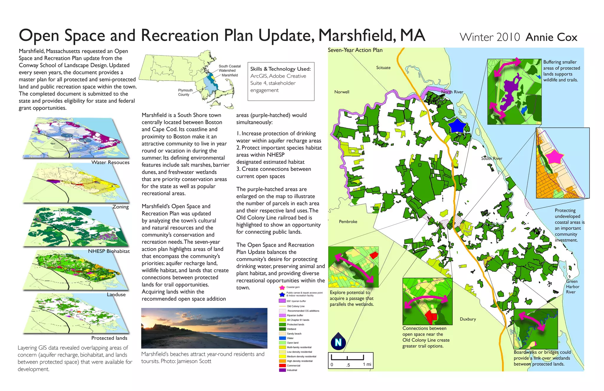
Coastal gem
Public canoe & kayak access point
& Indoor recreation facility
300’ riparian buffer
Open Space and Recreation Plan Update, Marshfield, MA Winter 2010 Annie Cox
Marshfield is a South Shore town
centrally located between Boston
and Cape Cod. Its coastline and
proximity to Boston make it an
attractive community to live in year
round or vacation in during the
summer. Its defining environmental
features include salt marshes, barrier
dunes, and freshwater wetlands
that are priority conservation areas
for the state as well as popular
recreational areas.
Marshfield’s Open Space and
Recreation Plan was updated
by analyzing the town’s cultural
and natural resources and the
community’s conservation and
recreation needs.The seven-year
action plan highlights areas of land
that encompass the community’s
priorities: aquifer recharge land,
wildlife habitat, and lands that create
connections between protected
lands for trail opportunities.
Acquiring lands within the
recommended open space addition
areas (purple-hatched) would
simultaneously:
1. Increase protection of drinking
water within aquifer recharge areas
2. Protect important species habitat
areas within NHESP 	
designated estimated habitat
3. Create connections between
current open spaces
The purple-hatched areas are
enlarged on the map to illustrate
the number of parcels in each area
and their respective land uses.The
Old Colony Line railroad bed is
highlighted to show an opportunity
for connecting public lands.
The Open Space and Recreation
Plan Update balances the
community’s desire for protecting
drinking water, preserving animal and
plant habitat, and providing diverse
recreational opportunities within the
town.
Water Resouces
NHESP Biohabitat
Protected lands
Zoning
Landuse
Plymouth
County
South Coastal
Watershed
Marshfield
Boardwalks or bridges could
provide a link over wetlands
between protected lands.
Connections between
open space near the
Old Colony Line create
greater trail options.
Explore potential to
acquire a passage that
parallels the wetlands.
Protecting
undeveloped
coastal areas is
an important
community
investment.
0 .5 1 mi
N
Marshfield’s beaches attract year-round residents and
toursits. Photo: Jamieson Scott
Seven-Year Action Plan
Skills & Technology Used:
ArcGIS, Adobe Creative
Suite 4, stakeholder
engagement
Buffering smaller
areas of protected
lands supports
wildlife and trails.
Layering GIS data revealed overlapping areas of
concern (aquifer recharge, biohabitat, and lands
between protected space) that were available for
development.
Norwell
Scituate
Pembroke
Duxbury
Green
Harbor
River
South River
North River
Marshfield, Massachusetts requested an Open
Space and Recreation Plan update from the
Conway School of Landscape Design. Updated
every seven years, the document provides a
master plan for all protected and semi-protected
land and public recreation space within the town.
The completed document is submitted to the
state and provides eligibility for state and federal
grant opportunities.
Fill
cut
existing slope
Adams Residence, Residential Design, Greenfield, MA Fall 2009 Annie Cox
The Adams family asked for
a solution to the eroded
slope on the western edge
of their property. The slope
is currently held by rotted
railroad ties.
An old streambed bisects the
PoolFence
Walk
way
Walk
way
Side
walk Davis Street
Slope held by railroad 
ties and vegetation Deck
House
The final design stabilizes
the slope by terracing it
into the yard. A two and
one-half feet high retaining
wall bisects the backyard,
creating a curving step
down into the lower yard.
A path leads from the
backyard to the neighbor’s
yard, which also is held by
a two and one-half feet
high retaining wall.
Graded plan showing
new planting plan
Proposed Grading Plan
Five steps (12 inches deep, 6 inches tall)
connect the upper and lower yards.
Regrading the slope allows for a 10% slope
path through an edible garden.
Final design showing new entrance
Section A-A’
The 19th-century home
has two driveways, a pool
and a deck.The family
would like to maintain
areas of play for their
daughter and vehicular
access to the pool.
87
T.O.
Wall
88
B.O.
Wall
85.5
85
86
89
93
92
90
+ T.O.
Wall 98
97
96
95
94
B.O.
Wall
95.5
lower
yard
upper
yard
+
+
+
pool
91
Skills & Technology Used:
Site Surveying, Grading,
Vectorworks, Adobe Creative
Suite 4 & Sketchup
Neighborhood Context
Rotting railroad ties and
vegetation support the west side
of the property.
The relatively flat quarter-acre property contrasts sharply with the
15% slope on the western edge. Stormwater sheets off the property
onto the neigbhors’.
B B'
retaining walls
neighborhood north to south creating a 10- to 15-feet
elevation change between properties.The owners of the six
affected properties have addressed erosion of this slope in
various ways with limited success.
Walnut St.
DavisSt.
A
Existing Conditions
N
embankment
house
pool
garage
A'
approximate
property
boundaries
path
upper
yard
lower yard
neighbor’syard
Section B-B’ Cutting and filling the slope allows for a
terraced yard, creating safe play areas.
Final Design
Davis Street Feasibility Study, Greenfield, MA
Community
Garden
Former
Grammar
School Kiosk Compost
Station
Shed
The Davis Street property is in a neighborhood setting.
Main Entrance
Handicapped Entrance
0’ 15’ 35’ 70’
C C’
Downtown
Hillside
Neighborhood
Davis Street
Property
Multi-Modal Train Station
1/2 Mile radius
Public Parks
Existing Conditions
The City of Greenfield proposes to sell a
1.9-acre property on Davis Street, home
to a historical 1902 brick grammar
school building and ten-year-old community
garden in the downtown area.The city
has requested design redevelopment
alternatives for the site that could inform a
request for proposal (RFP) for developers.
These alternatives are meant to explore
a wide range of land use possibilities that
could benefit Greenfield.
Interviews were conducted with local
developers, realtors, county economists,
neighbors, architects, planners, engineers
and community members to establish the
financial and social needs of Greenfield.
These needs help shape what the existing
building and site three blocks from
downtown could support economically and socially.
Analysis of site conditions,
including drainage, sun and shade,
views, access and circulation,
vegetation, zoning, and legal
setbacks, coupled with the
goals and needs of the city
have informed explorations of
possible future uses of the site at
different development densities.
Greenfield, MA
High-Density Alternative
Design Alternatives The spatial relationship of the site has been
explored at different development densities. Each design keeps parking
in the north to maximize solar potential for the building, and keep the
parking from dominating the site. Parking lot sizes have been minimized;
depending on the use of each building, a zoning variance will likely be
necessary to have less parking than is currently required. Each design
incorporates a public gathering space to acknowledge the existing
use of the site for social interaction and need for space within the
community. The community garden is present in each design but in
different sizes. Open space area varies considerably but all designs have
some outdoor seating and plazas for occupant and public gathering.
Stormwater is filtered and collected in infiltration basins to be treated
on site.
Section A-A' NTS: People sitting behind the infiltration
basin and people working in the garden
A A’
Low-Density Alternative
Medium-Density Alternative
School St
Parking
Parking Parking
Gathering
Space
Community
GardenInfiltration basin
new
building
new
building
new
building
The existing building is redeveloped for a single or multi-purpose use with
a reduced parking area. Open space has been enhanced, and the community
gardens have been increased.
community
gardens
parking
plazaA A’
Section B-B' NTS: People circulating toward and
sitting in the plaza.
One to two buildings are added to the site, and the existing
building is redeveloped.The new buildings and additional
parking reduce the open space and community garden.
parking
parking
new bldg
cmnty
garden
BB’
B B’
Three buildings are added to the site. Having four buildings on the
site creates the greatest requirement for parking and leaves the least
room for open space.The community gardens are greatly reduced or
eliminated.
Section C-C'. NTS: People enjoying the landscape between the buildings.
Hand drawn and SketchUp renderings showing the
relationship among open space, parking and future
buildings
Spring 2010 Annie Cox
The former grammar school building
viewed from the east.
CC’
Skills  Technology Used:
Site Surveying,Vectorworks,
Adobe Creative Suite 4,
AutoCAD  Sketchup

Cox.CutSheets2015

  • 1.
    Coastal gem Public canoe& kayak access point & Indoor recreation facility 300’ riparian buffer Open Space and Recreation Plan Update, Marshfield, MA Winter 2010 Annie Cox Marshfield is a South Shore town centrally located between Boston and Cape Cod. Its coastline and proximity to Boston make it an attractive community to live in year round or vacation in during the summer. Its defining environmental features include salt marshes, barrier dunes, and freshwater wetlands that are priority conservation areas for the state as well as popular recreational areas. Marshfield’s Open Space and Recreation Plan was updated by analyzing the town’s cultural and natural resources and the community’s conservation and recreation needs.The seven-year action plan highlights areas of land that encompass the community’s priorities: aquifer recharge land, wildlife habitat, and lands that create connections between protected lands for trail opportunities. Acquiring lands within the recommended open space addition areas (purple-hatched) would simultaneously: 1. Increase protection of drinking water within aquifer recharge areas 2. Protect important species habitat areas within NHESP designated estimated habitat 3. Create connections between current open spaces The purple-hatched areas are enlarged on the map to illustrate the number of parcels in each area and their respective land uses.The Old Colony Line railroad bed is highlighted to show an opportunity for connecting public lands. The Open Space and Recreation Plan Update balances the community’s desire for protecting drinking water, preserving animal and plant habitat, and providing diverse recreational opportunities within the town. Water Resouces NHESP Biohabitat Protected lands Zoning Landuse Plymouth County South Coastal Watershed Marshfield Boardwalks or bridges could provide a link over wetlands between protected lands. Connections between open space near the Old Colony Line create greater trail options. Explore potential to acquire a passage that parallels the wetlands. Protecting undeveloped coastal areas is an important community investment. 0 .5 1 mi N Marshfield’s beaches attract year-round residents and toursits. Photo: Jamieson Scott Seven-Year Action Plan Skills & Technology Used: ArcGIS, Adobe Creative Suite 4, stakeholder engagement Buffering smaller areas of protected lands supports wildlife and trails. Layering GIS data revealed overlapping areas of concern (aquifer recharge, biohabitat, and lands between protected space) that were available for development. Norwell Scituate Pembroke Duxbury Green Harbor River South River North River Marshfield, Massachusetts requested an Open Space and Recreation Plan update from the Conway School of Landscape Design. Updated every seven years, the document provides a master plan for all protected and semi-protected land and public recreation space within the town. The completed document is submitted to the state and provides eligibility for state and federal grant opportunities.
  • 2.
    Fill cut existing slope Adams Residence,Residential Design, Greenfield, MA Fall 2009 Annie Cox The Adams family asked for a solution to the eroded slope on the western edge of their property. The slope is currently held by rotted railroad ties. An old streambed bisects the PoolFence Walk way Walk way Side walk Davis Street Slope held by railroad  ties and vegetation Deck House The final design stabilizes the slope by terracing it into the yard. A two and one-half feet high retaining wall bisects the backyard, creating a curving step down into the lower yard. A path leads from the backyard to the neighbor’s yard, which also is held by a two and one-half feet high retaining wall. Graded plan showing new planting plan Proposed Grading Plan Five steps (12 inches deep, 6 inches tall) connect the upper and lower yards. Regrading the slope allows for a 10% slope path through an edible garden. Final design showing new entrance Section A-A’ The 19th-century home has two driveways, a pool and a deck.The family would like to maintain areas of play for their daughter and vehicular access to the pool. 87 T.O. Wall 88 B.O. Wall 85.5 85 86 89 93 92 90 + T.O. Wall 98 97 96 95 94 B.O. Wall 95.5 lower yard upper yard + + + pool 91 Skills & Technology Used: Site Surveying, Grading, Vectorworks, Adobe Creative Suite 4 & Sketchup Neighborhood Context Rotting railroad ties and vegetation support the west side of the property. The relatively flat quarter-acre property contrasts sharply with the 15% slope on the western edge. Stormwater sheets off the property onto the neigbhors’. B B' retaining walls neighborhood north to south creating a 10- to 15-feet elevation change between properties.The owners of the six affected properties have addressed erosion of this slope in various ways with limited success. Walnut St. DavisSt. A Existing Conditions N embankment house pool garage A' approximate property boundaries path upper yard lower yard neighbor’syard Section B-B’ Cutting and filling the slope allows for a terraced yard, creating safe play areas. Final Design
  • 3.
    Davis Street FeasibilityStudy, Greenfield, MA Community Garden Former Grammar School Kiosk Compost Station Shed The Davis Street property is in a neighborhood setting. Main Entrance Handicapped Entrance 0’ 15’ 35’ 70’ C C’ Downtown Hillside Neighborhood Davis Street Property Multi-Modal Train Station 1/2 Mile radius Public Parks Existing Conditions The City of Greenfield proposes to sell a 1.9-acre property on Davis Street, home to a historical 1902 brick grammar school building and ten-year-old community garden in the downtown area.The city has requested design redevelopment alternatives for the site that could inform a request for proposal (RFP) for developers. These alternatives are meant to explore a wide range of land use possibilities that could benefit Greenfield. Interviews were conducted with local developers, realtors, county economists, neighbors, architects, planners, engineers and community members to establish the financial and social needs of Greenfield. These needs help shape what the existing building and site three blocks from downtown could support economically and socially. Analysis of site conditions, including drainage, sun and shade, views, access and circulation, vegetation, zoning, and legal setbacks, coupled with the goals and needs of the city have informed explorations of possible future uses of the site at different development densities. Greenfield, MA High-Density Alternative Design Alternatives The spatial relationship of the site has been explored at different development densities. Each design keeps parking in the north to maximize solar potential for the building, and keep the parking from dominating the site. Parking lot sizes have been minimized; depending on the use of each building, a zoning variance will likely be necessary to have less parking than is currently required. Each design incorporates a public gathering space to acknowledge the existing use of the site for social interaction and need for space within the community. The community garden is present in each design but in different sizes. Open space area varies considerably but all designs have some outdoor seating and plazas for occupant and public gathering. Stormwater is filtered and collected in infiltration basins to be treated on site. Section A-A' NTS: People sitting behind the infiltration basin and people working in the garden A A’ Low-Density Alternative Medium-Density Alternative School St Parking Parking Parking Gathering Space Community GardenInfiltration basin new building new building new building The existing building is redeveloped for a single or multi-purpose use with a reduced parking area. Open space has been enhanced, and the community gardens have been increased. community gardens parking plazaA A’ Section B-B' NTS: People circulating toward and sitting in the plaza. One to two buildings are added to the site, and the existing building is redeveloped.The new buildings and additional parking reduce the open space and community garden. parking parking new bldg cmnty garden BB’ B B’ Three buildings are added to the site. Having four buildings on the site creates the greatest requirement for parking and leaves the least room for open space.The community gardens are greatly reduced or eliminated. Section C-C'. NTS: People enjoying the landscape between the buildings. Hand drawn and SketchUp renderings showing the relationship among open space, parking and future buildings Spring 2010 Annie Cox The former grammar school building viewed from the east. CC’ Skills Technology Used: Site Surveying,Vectorworks, Adobe Creative Suite 4, AutoCAD Sketchup