SlideShare a Scribd company logo
1 of 1
Download to read offline
Università degli studi della Basilicata                                                                                                                                                                                                                                                                               13° CONFERENZA NAZIONALE
                           Facoltà di ingegneria                                                                                                                                                                                                                                                                                          ASITA
                                DAPIT - LISUT                                                                                                                                                                                                                                                                         1 – 4 dicembre 2009 BARI

   L’INFRASTRUTTURA DI DATI SPAZIALI DEL PIT MARMO PLATANO MELANDRO
                                                                                                        Salvatore Larosa(*), Lucia Tilio(*), Viviana Lanza(*), Gabriele Nolè(*)

                                                                                  (*) Università degli Studi della Basilicata, Viale dell’Ateneo Lucano 10, tel e fax 0971/205127,
                                                                                                          sal.larosa@libero.it, nome.cognome@unibas.it

                                                                                   PROGRAMMA DI RICERCA                        L’uso dei Sistemi Informativi                                        E’ consuetudine che le amministrazioni che
 INTRODUZIONE


                                                                                          PER                                  Geografici nelle ultime decadi ha                                    riescono a dotarsi di un Sistema Informativo
                                                                                                                               profondamente semplificato la
                                                                                                                                                                                                    Geografico (GIS), con un investimento che pesa


                                                                                                                                                                                 DAI GIS…ALLE IDS
                                                                                                                                                                                                                                                                                                                      indirizzare
                                                                             Un nuovo modello di governance che                gestione degli strumenti di                                                                                                                                             monitorare      in modo

                                                                                                                               governo        del   territorio; nel                                 sul bilancio, dimentichino di aggiornare il loro                                                    i risultati   efficace gli
                                                                             favorisca lo sviluppo locale, attraverso                                                                                                                                                                                                 interventi,
                                                                                                                               contesto della programmazione                                        sistema.
                                                                             il raggiungimento degli
                                                                                                                               l’innovazione introdotta è legata                                    Le Infrastrutture di Dati Spaziali (IDS),                                                               valutare gli
                                                                                                                                                                                                                                                                                                              impatti
                                                                                                                               alla possibilità di localizzare le                                   caratterizzate dalle sinergie che si creano tra
                                                                                             OBIETTIVi                         scelte e metterle in relazione con                                   diversi enti e soggetti che partecipano alla loro
                                                                                                DI                             gli altri strumenti urbanistici.                                     realizzazione permettono di superare questo
                                                                                                                               Lo sviluppo delle ICT, inoltre,                                      limite.
                                                                             - territorializzare la programmazione
                                                                                                                               spinge verso la gestione “real                                       Le IDS possono essere pensate come grandi
                                                                             economica                                                                                                                                                                                                                Spatial Data
                                                                                                                               time” del territorio, e rende
                                                                             - condividere l’informazione geografica                                                                                banche dati distribuite nello spazio, che grazie a                                            Infrastructure (SDI)
                                                                                                                               possibile diffondere l’infomazione
                                                                             - innescare un nuovo modo per                                                                                          protocolli e politiche di sinergia garantiscono
                                                                                                                               geografica, attraverso tools user                                                                                                                            condivisione ed uso efficiente
                                                                             conoscere, partecipare e pianificare.                                                                                  l’interoperabilità tra i sistemi ed i dati forniti da
                                                                                                                               friendly.                                                                                                                                                     dell’informazione geografica
                                                                                                                                                                                                    diversi utenti.

                                                                 Al fine di diffondere i dati raccolti nelle IDS il GIS viene oggi


                                                                                                                                                                                                                                                                                                                                                               IL PROGETTO - PIT MPM
                                                                                                                                                                                                                                                                                                                                                               IL PROGETTO - PIT MPM
                                                                                                                                                                                                                                                                                                                                                               IL PROGETTO
                                                                                                                                                                                                                                                                                                                                                               IL PROGETTO
                                                                 esteso in ambiente web basato su soluzioni Open Source,
                                                                 sviluppando sistemi WEBGIS in grado di consentire la
                                PIT MPM                          consultazione e l’interrogazione dei sistemi informativi
                           Progetto Integrato                    geografici mediante internet.
                              Territoriale
                            Marmo Platano
                               Melandro
                                                                                          Realizzazione
                                                                                      “Banca dati, studi e
                                                                                     progetti per la tutela
                                                                                                    e
                                                                                       valorizzazione del
                                                                                       patrimonio rurale”
                                   LISUT
                             Laboratorio di
                               Ingegneria
                           dei Sistemi Urbani
                               Territoriali
 ARCHITETTURA DI SISTEMA


                                                 Il WEBGIS                                                                        Le tecnologie Open Source, rappresentano                                                                                              L’architettura è stata realizzata seguendo le
                              1                  (http://www.pitmpm.basilicata.it/)
                                                 è stato sviluppato secondo
                                                                                                                   2              l’ambiente di lavoro:
                                                                                                                                  Debian GNU/Linux è il Sistema Operativo, sul quale
                                                                                                                                                                                                                                                   3                    specifiche dell’Open GIS Consortium, garantendo lo
                                                                                                                                                                                                                                                                        standard di interscambio/interoperabilità per i sistemi
                                                 un’architettura di tipo client-                                                  lavorano soltanto software open source.                                                                                               WEBGIS.
                                                 server in ambiente Web                                                           La consultazione/navigazione avviene in modalità                                                                                      Le scelte effettuate rendono il sistema flessibile, e
                                                                                                                                  INTERNET (o INTRANET), mentre l’aggiornamento e                                                                                       sono state modulate in modo che eventuali nuove
                                                                                                                                  la manutenzione in modalità Client-Server.                                                                                            funzionalità possano essere integrate facilmente.


                                                                                               APACHE: Gestione
                                                                                                                                                                                                                                 Il DBMS spaziale
                                                                                               parte server
                                                                                                                                                                                                                                 realizzato consente di
                                                                                                                                                                                                                                 gestire tutte le
                                                                                               PostgreSQL:                                                                                                                       informazioni, da quelle
                                                                                               database che gestisce i                                                                                                           geografiche a quelle
                                                                                               contenuti                                                                                                                         semantiche.
                                                                                                                                                      L’estrazione dell’entità
                                                                                                                                                      geometriche e degli attributi
                                                                                               Postgis: Software                                      ad esse associate avviene
                                                                                                                                                      definendo interrogazioni
                                                                                               che supporta
                                                                                                                                                      basate sul linguaggio SQL
                                                                                               l’estensione spaziale                                  standard.


                                                    I CONTENUTI DEL WEBGIS                                                                                                                              OGGI…                                                                                 IN FUTURO…
                           Mappa del territorio del PIT Marmo Platano
                                            Melandro                                                                                                                           PIT MARMO PLATANO MELANDRO                                                                                            SVILUPPI FUTURI
                              Legenda relativa agli strati informativi
                                                                                                                                                                             Un nuovo modello di governance fortemente basato
                                                                                                                                                     CONCLUSIONI


                                          visualizzati                                                                                                                                                                                                                                 Rafforzamento della sinergia degli enti locali
                                                                                                                                                                             sul connubio GIS + ICT in ambiente open source
                           Elenco degli Strati Informativi visualizzabili,
                                    suddivisi in macrogruppi


                                   Risultato delle interrogazioni                                                                                                       NUOVI STRUMENTI PER IL GOVERNO DEL                                                                        UN NUOVO RUOLO PER IL PIT MPM
                                                                                                                                                                                   TERRITORIO
                                             Overview                                                                                                                         La condivisione dell’informazione geografica come
                                                                                                                                                                                                                                                                                Da soggetto principale a coordinatore degli enti locali
                                                                                                                                                                                          principio fondamentale
                           Barra delle scala e delle funzioni disponibili


                               Barra per la funzione di “cerca per”                                                                                                  VERSO LA PARTECIPAZIONE NEI PROCESSI                                                                 MANTENIMENTO ED ULTERIORE SVILUPPO
                                                                                                                                                                             DI PROGRAMMAZIONE                                                                                         DELL’IDS
                                                                                                                                                                               Il WEBGIS come strumento indispensabile per la                                                         Contributo di tutti gli enti locali all’aggiornamento del sistema
                                                                                                                                                                                                                                                                                Allargamento della rete di enti coinvolti e conseguente crescita dell’IDS
                                                                                                                Zoom                                                      valutazione delle politiche e la trasparenza dei processi
                    La modellazione dell’infrastruttura di                                                                                                                                                                                                                    Adozione di protocolli e specifiche di supporto alle attività condotte dagli enti
                                                                                                                                                                                                  decisionali                                                                                                        locali
                    dati è avvenuta attraverso il linguaggio                                                     Pan
                    di specifica UML, nella sua estensione
                                                                                                         Zoom alla selezione
                    orientata agli oggetti        geografici,                                                                                     Annoni A., Salvemini M., Vico F. (2004), “Infrastrutture di dati territoriali, web services, sistemi informativi diffusi: convergenza tra evoluzioni tecnologiche e concettuali”, 8° Conferenza Nazionale
                                                                                                                                                  ASITA, - GEOMATICA – Standardizzazione, interoperabilità e nuove tecnologie, Roma, Italia.
                                                                                                                                                                                                                                                                                                                                                                         BIBLIOGRAFIA


                    GeoUML, adottato dallo standard ISO                                                        Identify                           Di Donato P. (2008), “Infrastrutture di dati territoriali e la direttiva INSPIRE”, in Murgante B., Informazione geografica a supporto della pianificazione territoriale, FrancoAngeli.
                    TC 211 e da Intesa GIS.                                                                                                       Pelagatti G. (a cura di) (2004), “Il modello concettuale GeoUML – Inquadramento generale e introduzione all'uso”, Intesa GIS.
                                                                                                                                                  Hart D., Phillips H. (1997), “Metadata Primer – A “how to” guide on metadata implementation”, Mitchell. T. (2005), Web mapping illustrated: Using Open Source GIS Toolkits, O’Reilly.
                    Ogni class definita dal modello è                                                        Autoidentify                         National States Geographic Information Council, http://www.lic.wisc.edu/metadata/metaprim.htm (ultimo accesso 07/2009).
                    corredata da un metadato, compilato                                                                                           Nerbert D.D. (2004), “Developing Spatial Data Infrastructure: The SDI Cookbook, Version 2.0”, http://www.gsdi.org/docs2004/Cookbook/cookbookV2.0.pdf, (ultimoaccesso 07/2009).
                                                                                                              Seleziona                           Neteler, M., Mitasova H. (2004), Open Source GIS: A GRASS GIS Approach, Second Edition, Boston: Kluwer Academic Publishers/Springer.
                    secondo lo standard ISO 19115, nella                                                                                          Ottens H., (2004), “An Information Model for Strategic Spatial Policy Documents”, 7° Agile Conference on Geographic Information Science, Heraklion, Greece.
                    versione CORE e seguendo lo schema                                                         Stampa
                                                                                                                                                  Salvemini M. (2003), “L’iniziativa Europea INSPIRE e la realtà locale italiana: opportunità e possibili sviluppi”, 7° Conferenza Nazionale ASITA GEOMATICA – L’informazione territoriale e la
                                                                                                                                                  dimensione Tempo, Verona, Italia.
                    del Repertorio Nazionale dei Metadati                                                                                         Salvemini M. (2004), “Proposte per azioni orientate alla realizzazione delle infrastrutture di Dati Territoriali, Contributo al dibattito e ai lavori circa la Direttiva INSPIRE e le azioni da intraprendere,
                    (CNIPA).                                                                                 Foto Gallery                         Quaderno 03/2004, LABSITA, Roma, Italia.
                                                                                                                                                  Sciabarrà M. (2003), Il software Open Source e gli standard aperti, Milano, McGraw Hill.
                                                                                                                                                  Stallman R. (2002), Free Software, Free Society: The Selected Essays of Richard M. Stallman, Joshua Gay Editore.
                                                                                                                                                  Whiteside A., Evans J.D. (2008), “OpenGIS Web Coverage Service Implementation Standard”, RN OGC 07-076r5, http://www.opengeospatial.org/, (ultimo accesso 07/2009).

More Related Content

Featured

2024 State of Marketing Report – by Hubspot
2024 State of Marketing Report – by Hubspot2024 State of Marketing Report – by Hubspot
2024 State of Marketing Report – by HubspotMarius Sescu
 
Everything You Need To Know About ChatGPT
Everything You Need To Know About ChatGPTEverything You Need To Know About ChatGPT
Everything You Need To Know About ChatGPTExpeed Software
 
Product Design Trends in 2024 | Teenage Engineerings
Product Design Trends in 2024 | Teenage EngineeringsProduct Design Trends in 2024 | Teenage Engineerings
Product Design Trends in 2024 | Teenage EngineeringsPixeldarts
 
How Race, Age and Gender Shape Attitudes Towards Mental Health
How Race, Age and Gender Shape Attitudes Towards Mental HealthHow Race, Age and Gender Shape Attitudes Towards Mental Health
How Race, Age and Gender Shape Attitudes Towards Mental HealthThinkNow
 
AI Trends in Creative Operations 2024 by Artwork Flow.pdf
AI Trends in Creative Operations 2024 by Artwork Flow.pdfAI Trends in Creative Operations 2024 by Artwork Flow.pdf
AI Trends in Creative Operations 2024 by Artwork Flow.pdfmarketingartwork
 
PEPSICO Presentation to CAGNY Conference Feb 2024
PEPSICO Presentation to CAGNY Conference Feb 2024PEPSICO Presentation to CAGNY Conference Feb 2024
PEPSICO Presentation to CAGNY Conference Feb 2024Neil Kimberley
 
Content Methodology: A Best Practices Report (Webinar)
Content Methodology: A Best Practices Report (Webinar)Content Methodology: A Best Practices Report (Webinar)
Content Methodology: A Best Practices Report (Webinar)contently
 
How to Prepare For a Successful Job Search for 2024
How to Prepare For a Successful Job Search for 2024How to Prepare For a Successful Job Search for 2024
How to Prepare For a Successful Job Search for 2024Albert Qian
 
Social Media Marketing Trends 2024 // The Global Indie Insights
Social Media Marketing Trends 2024 // The Global Indie InsightsSocial Media Marketing Trends 2024 // The Global Indie Insights
Social Media Marketing Trends 2024 // The Global Indie InsightsKurio // The Social Media Age(ncy)
 
Trends In Paid Search: Navigating The Digital Landscape In 2024
Trends In Paid Search: Navigating The Digital Landscape In 2024Trends In Paid Search: Navigating The Digital Landscape In 2024
Trends In Paid Search: Navigating The Digital Landscape In 2024Search Engine Journal
 
5 Public speaking tips from TED - Visualized summary
5 Public speaking tips from TED - Visualized summary5 Public speaking tips from TED - Visualized summary
5 Public speaking tips from TED - Visualized summarySpeakerHub
 
ChatGPT and the Future of Work - Clark Boyd
ChatGPT and the Future of Work - Clark Boyd ChatGPT and the Future of Work - Clark Boyd
ChatGPT and the Future of Work - Clark Boyd Clark Boyd
 
Getting into the tech field. what next
Getting into the tech field. what next Getting into the tech field. what next
Getting into the tech field. what next Tessa Mero
 
Google's Just Not That Into You: Understanding Core Updates & Search Intent
Google's Just Not That Into You: Understanding Core Updates & Search IntentGoogle's Just Not That Into You: Understanding Core Updates & Search Intent
Google's Just Not That Into You: Understanding Core Updates & Search IntentLily Ray
 
Time Management & Productivity - Best Practices
Time Management & Productivity -  Best PracticesTime Management & Productivity -  Best Practices
Time Management & Productivity - Best PracticesVit Horky
 
The six step guide to practical project management
The six step guide to practical project managementThe six step guide to practical project management
The six step guide to practical project managementMindGenius
 
Beginners Guide to TikTok for Search - Rachel Pearson - We are Tilt __ Bright...
Beginners Guide to TikTok for Search - Rachel Pearson - We are Tilt __ Bright...Beginners Guide to TikTok for Search - Rachel Pearson - We are Tilt __ Bright...
Beginners Guide to TikTok for Search - Rachel Pearson - We are Tilt __ Bright...RachelPearson36
 

Featured (20)

2024 State of Marketing Report – by Hubspot
2024 State of Marketing Report – by Hubspot2024 State of Marketing Report – by Hubspot
2024 State of Marketing Report – by Hubspot
 
Everything You Need To Know About ChatGPT
Everything You Need To Know About ChatGPTEverything You Need To Know About ChatGPT
Everything You Need To Know About ChatGPT
 
Product Design Trends in 2024 | Teenage Engineerings
Product Design Trends in 2024 | Teenage EngineeringsProduct Design Trends in 2024 | Teenage Engineerings
Product Design Trends in 2024 | Teenage Engineerings
 
How Race, Age and Gender Shape Attitudes Towards Mental Health
How Race, Age and Gender Shape Attitudes Towards Mental HealthHow Race, Age and Gender Shape Attitudes Towards Mental Health
How Race, Age and Gender Shape Attitudes Towards Mental Health
 
AI Trends in Creative Operations 2024 by Artwork Flow.pdf
AI Trends in Creative Operations 2024 by Artwork Flow.pdfAI Trends in Creative Operations 2024 by Artwork Flow.pdf
AI Trends in Creative Operations 2024 by Artwork Flow.pdf
 
Skeleton Culture Code
Skeleton Culture CodeSkeleton Culture Code
Skeleton Culture Code
 
PEPSICO Presentation to CAGNY Conference Feb 2024
PEPSICO Presentation to CAGNY Conference Feb 2024PEPSICO Presentation to CAGNY Conference Feb 2024
PEPSICO Presentation to CAGNY Conference Feb 2024
 
Content Methodology: A Best Practices Report (Webinar)
Content Methodology: A Best Practices Report (Webinar)Content Methodology: A Best Practices Report (Webinar)
Content Methodology: A Best Practices Report (Webinar)
 
How to Prepare For a Successful Job Search for 2024
How to Prepare For a Successful Job Search for 2024How to Prepare For a Successful Job Search for 2024
How to Prepare For a Successful Job Search for 2024
 
Social Media Marketing Trends 2024 // The Global Indie Insights
Social Media Marketing Trends 2024 // The Global Indie InsightsSocial Media Marketing Trends 2024 // The Global Indie Insights
Social Media Marketing Trends 2024 // The Global Indie Insights
 
Trends In Paid Search: Navigating The Digital Landscape In 2024
Trends In Paid Search: Navigating The Digital Landscape In 2024Trends In Paid Search: Navigating The Digital Landscape In 2024
Trends In Paid Search: Navigating The Digital Landscape In 2024
 
5 Public speaking tips from TED - Visualized summary
5 Public speaking tips from TED - Visualized summary5 Public speaking tips from TED - Visualized summary
5 Public speaking tips from TED - Visualized summary
 
ChatGPT and the Future of Work - Clark Boyd
ChatGPT and the Future of Work - Clark Boyd ChatGPT and the Future of Work - Clark Boyd
ChatGPT and the Future of Work - Clark Boyd
 
Getting into the tech field. what next
Getting into the tech field. what next Getting into the tech field. what next
Getting into the tech field. what next
 
Google's Just Not That Into You: Understanding Core Updates & Search Intent
Google's Just Not That Into You: Understanding Core Updates & Search IntentGoogle's Just Not That Into You: Understanding Core Updates & Search Intent
Google's Just Not That Into You: Understanding Core Updates & Search Intent
 
How to have difficult conversations
How to have difficult conversations How to have difficult conversations
How to have difficult conversations
 
Introduction to Data Science
Introduction to Data ScienceIntroduction to Data Science
Introduction to Data Science
 
Time Management & Productivity - Best Practices
Time Management & Productivity -  Best PracticesTime Management & Productivity -  Best Practices
Time Management & Productivity - Best Practices
 
The six step guide to practical project management
The six step guide to practical project managementThe six step guide to practical project management
The six step guide to practical project management
 
Beginners Guide to TikTok for Search - Rachel Pearson - We are Tilt __ Bright...
Beginners Guide to TikTok for Search - Rachel Pearson - We are Tilt __ Bright...Beginners Guide to TikTok for Search - Rachel Pearson - We are Tilt __ Bright...
Beginners Guide to TikTok for Search - Rachel Pearson - We are Tilt __ Bright...
 

Conferenza ASITA 2009

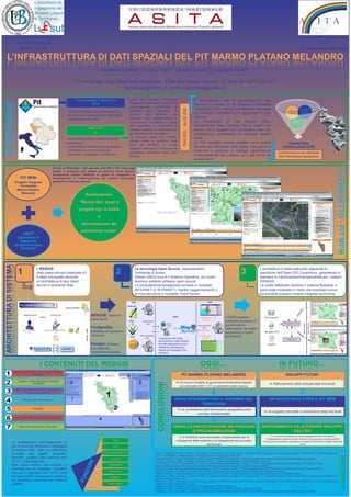
  • 1. Università degli studi della Basilicata 13° CONFERENZA NAZIONALE Facoltà di ingegneria ASITA DAPIT - LISUT 1 – 4 dicembre 2009 BARI L’INFRASTRUTTURA DI DATI SPAZIALI DEL PIT MARMO PLATANO MELANDRO Salvatore Larosa(*), Lucia Tilio(*), Viviana Lanza(*), Gabriele Nolè(*) (*) Università degli Studi della Basilicata, Viale dell’Ateneo Lucano 10, tel e fax 0971/205127, sal.larosa@libero.it, nome.cognome@unibas.it PROGRAMMA DI RICERCA L’uso dei Sistemi Informativi E’ consuetudine che le amministrazioni che INTRODUZIONE PER Geografici nelle ultime decadi ha riescono a dotarsi di un Sistema Informativo profondamente semplificato la Geografico (GIS), con un investimento che pesa DAI GIS…ALLE IDS indirizzare Un nuovo modello di governance che gestione degli strumenti di monitorare in modo governo del territorio; nel sul bilancio, dimentichino di aggiornare il loro i risultati efficace gli favorisca lo sviluppo locale, attraverso interventi, contesto della programmazione sistema. il raggiungimento degli l’innovazione introdotta è legata Le Infrastrutture di Dati Spaziali (IDS), valutare gli impatti alla possibilità di localizzare le caratterizzate dalle sinergie che si creano tra OBIETTIVi scelte e metterle in relazione con diversi enti e soggetti che partecipano alla loro DI gli altri strumenti urbanistici. realizzazione permettono di superare questo Lo sviluppo delle ICT, inoltre, limite. - territorializzare la programmazione spinge verso la gestione “real Le IDS possono essere pensate come grandi economica Spatial Data time” del territorio, e rende - condividere l’informazione geografica banche dati distribuite nello spazio, che grazie a Infrastructure (SDI) possibile diffondere l’infomazione - innescare un nuovo modo per protocolli e politiche di sinergia garantiscono geografica, attraverso tools user condivisione ed uso efficiente conoscere, partecipare e pianificare. l’interoperabilità tra i sistemi ed i dati forniti da friendly. dell’informazione geografica diversi utenti. Al fine di diffondere i dati raccolti nelle IDS il GIS viene oggi IL PROGETTO - PIT MPM IL PROGETTO - PIT MPM IL PROGETTO IL PROGETTO esteso in ambiente web basato su soluzioni Open Source, sviluppando sistemi WEBGIS in grado di consentire la PIT MPM consultazione e l’interrogazione dei sistemi informativi Progetto Integrato geografici mediante internet. Territoriale Marmo Platano Melandro Realizzazione “Banca dati, studi e progetti per la tutela e valorizzazione del patrimonio rurale” LISUT Laboratorio di Ingegneria dei Sistemi Urbani Territoriali ARCHITETTURA DI SISTEMA Il WEBGIS Le tecnologie Open Source, rappresentano L’architettura è stata realizzata seguendo le 1 (http://www.pitmpm.basilicata.it/) è stato sviluppato secondo 2 l’ambiente di lavoro: Debian GNU/Linux è il Sistema Operativo, sul quale 3 specifiche dell’Open GIS Consortium, garantendo lo standard di interscambio/interoperabilità per i sistemi un’architettura di tipo client- lavorano soltanto software open source. WEBGIS. server in ambiente Web La consultazione/navigazione avviene in modalità Le scelte effettuate rendono il sistema flessibile, e INTERNET (o INTRANET), mentre l’aggiornamento e sono state modulate in modo che eventuali nuove la manutenzione in modalità Client-Server. funzionalità possano essere integrate facilmente. APACHE: Gestione Il DBMS spaziale parte server realizzato consente di gestire tutte le PostgreSQL: informazioni, da quelle database che gestisce i geografiche a quelle contenuti semantiche. L’estrazione dell’entità geometriche e degli attributi Postgis: Software ad esse associate avviene definendo interrogazioni che supporta basate sul linguaggio SQL l’estensione spaziale standard. I CONTENUTI DEL WEBGIS OGGI… IN FUTURO… Mappa del territorio del PIT Marmo Platano Melandro PIT MARMO PLATANO MELANDRO SVILUPPI FUTURI Legenda relativa agli strati informativi Un nuovo modello di governance fortemente basato CONCLUSIONI visualizzati Rafforzamento della sinergia degli enti locali sul connubio GIS + ICT in ambiente open source Elenco degli Strati Informativi visualizzabili, suddivisi in macrogruppi Risultato delle interrogazioni NUOVI STRUMENTI PER IL GOVERNO DEL UN NUOVO RUOLO PER IL PIT MPM TERRITORIO Overview La condivisione dell’informazione geografica come Da soggetto principale a coordinatore degli enti locali principio fondamentale Barra delle scala e delle funzioni disponibili Barra per la funzione di “cerca per” VERSO LA PARTECIPAZIONE NEI PROCESSI MANTENIMENTO ED ULTERIORE SVILUPPO DI PROGRAMMAZIONE DELL’IDS Il WEBGIS come strumento indispensabile per la Contributo di tutti gli enti locali all’aggiornamento del sistema Allargamento della rete di enti coinvolti e conseguente crescita dell’IDS Zoom valutazione delle politiche e la trasparenza dei processi La modellazione dell’infrastruttura di Adozione di protocolli e specifiche di supporto alle attività condotte dagli enti decisionali locali dati è avvenuta attraverso il linguaggio Pan di specifica UML, nella sua estensione Zoom alla selezione orientata agli oggetti geografici, Annoni A., Salvemini M., Vico F. (2004), “Infrastrutture di dati territoriali, web services, sistemi informativi diffusi: convergenza tra evoluzioni tecnologiche e concettuali”, 8° Conferenza Nazionale ASITA, - GEOMATICA – Standardizzazione, interoperabilità e nuove tecnologie, Roma, Italia. BIBLIOGRAFIA GeoUML, adottato dallo standard ISO Identify Di Donato P. (2008), “Infrastrutture di dati territoriali e la direttiva INSPIRE”, in Murgante B., Informazione geografica a supporto della pianificazione territoriale, FrancoAngeli. TC 211 e da Intesa GIS. Pelagatti G. (a cura di) (2004), “Il modello concettuale GeoUML – Inquadramento generale e introduzione all'uso”, Intesa GIS. Hart D., Phillips H. (1997), “Metadata Primer – A “how to” guide on metadata implementation”, Mitchell. T. (2005), Web mapping illustrated: Using Open Source GIS Toolkits, O’Reilly. Ogni class definita dal modello è Autoidentify National States Geographic Information Council, http://www.lic.wisc.edu/metadata/metaprim.htm (ultimo accesso 07/2009). corredata da un metadato, compilato Nerbert D.D. (2004), “Developing Spatial Data Infrastructure: The SDI Cookbook, Version 2.0”, http://www.gsdi.org/docs2004/Cookbook/cookbookV2.0.pdf, (ultimoaccesso 07/2009). Seleziona Neteler, M., Mitasova H. (2004), Open Source GIS: A GRASS GIS Approach, Second Edition, Boston: Kluwer Academic Publishers/Springer. secondo lo standard ISO 19115, nella Ottens H., (2004), “An Information Model for Strategic Spatial Policy Documents”, 7° Agile Conference on Geographic Information Science, Heraklion, Greece. versione CORE e seguendo lo schema Stampa Salvemini M. (2003), “L’iniziativa Europea INSPIRE e la realtà locale italiana: opportunità e possibili sviluppi”, 7° Conferenza Nazionale ASITA GEOMATICA – L’informazione territoriale e la dimensione Tempo, Verona, Italia. del Repertorio Nazionale dei Metadati Salvemini M. (2004), “Proposte per azioni orientate alla realizzazione delle infrastrutture di Dati Territoriali, Contributo al dibattito e ai lavori circa la Direttiva INSPIRE e le azioni da intraprendere, (CNIPA). Foto Gallery Quaderno 03/2004, LABSITA, Roma, Italia. Sciabarrà M. (2003), Il software Open Source e gli standard aperti, Milano, McGraw Hill. Stallman R. (2002), Free Software, Free Society: The Selected Essays of Richard M. Stallman, Joshua Gay Editore. Whiteside A., Evans J.D. (2008), “OpenGIS Web Coverage Service Implementation Standard”, RN OGC 07-076r5, http://www.opengeospatial.org/, (ultimo accesso 07/2009).