Community Meeting #2 - 7th & 8th Streets Alternatives
•
0 likes•269 views

Report
Share
Report
Share
Download to read offline

Recommended
Community Meeting #2 Slideshow Presentation
Community Meeting #2 Slideshow PresentationEastern Neighborhoods Transportation Implementation Planning Study
This document provides an overview of a community workshop to discuss preliminary design alternatives for three sets of streets in San Francisco: Folsom and Howard Streets, 7th and 8th Streets, and 16th Street. The agenda includes introducing the design alternatives for each corridor in breakout group discussions. The purpose is to get community input on alternatives that aim to improve transportation, safety, and the public realm while supporting appropriate development as part of the Eastern Neighborhoods Transportation Implementation Planning Study. Attendees will provide feedback on alternative designs through discussion, written comments, and prioritization voting. Refined design concepts and implementation strategies will be developed after the workshop.Nov 8, 2919 Task Force Future Conditions & Emerging Opportunities
Nov 8, 2919 Task Force Future Conditions & Emerging OpportunitiesEastern Neighborhoods Transportation Implementation Planning Study
This document discusses several transportation projects in San Francisco including a street plan, a transit effectiveness project, a bicycle plan, traffic calming measures, and SFpark. The projects aim to improve streets, transit, biking infrastructure, and manage traffic and parking through strategies such as traffic circles, speed cushions, and demand-based parking pricing.'Consensus' Book_Celebration of Entrepreneurship_Wamda_AbraajCapital
The document provides a long list of names of individuals. It does not contain any clear context or narrative to summarize. The names appear to be of people from the Middle East and North Africa region but no other essential information is gleaned from the document.
05.ENTRIPS
The document summarizes the analysis of circulation and operations for proposed transportation corridor projects in the Eastern Neighborhoods of San Francisco. It assessed potential impacts on traffic, the transportation network, transit delay, and signal timing. The analysis evaluated different design alternatives for Folsom Street, Howard Street, 7th Street, and 8th Street that vary the number of vehicle lanes, inclusion of transit and bicycle facilities, and direction of traffic flow. The preferred alternatives balance moving people by all modes efficiently while minimizing negative impacts to traffic flow and livability in the neighborhoods.
Task 3.a: Inventory of Key Eastern Neighborhood Priority Corridors
Task 3.a: Inventory of Key Eastern Neighborhood Priority CorridorsEastern Neighborhoods Transportation Implementation Planning Study
This document provides recommendations for prioritizing transportation corridor improvement projects in San Francisco's Eastern Neighborhoods based on an analysis of growth and transportation needs. Key steps included: 1) Dividing corridors into segments; 2) Assessing growth areas; 3) Scoring segments on bicycle, pedestrian, and transit needs; 4) Identifying outliers. Recommended priority corridors for near-term projects include segments of Folsom St, 3rd/4th Sts, and 5th/6th Sts due to high growth, multimodal needs, and safety issues. Other corridors may be addressed through other planning processes.Draft proposal
This document proposes a plan to increase donations to Sanjiwani by creating a blog about Nepal trekking and marketing it online. The plan is to make minor updates to Sanjiwani's existing website, launch a blog about trekking in Nepal with regular content, and use paid advertising and article marketing to drive visitors to the blog. The goal is to get people interested in trekking to sign up for an email series in exchange for asking them to donate. An initial budget of $800 is proposed to set up and test the marketing. If successful, the plan could be expanded to generate more ongoing fundraising through continued marketing spending.
Task 10: EN TRIPS Task Force Overview & Summary
Task 10: EN TRIPS Task Force Overview & SummaryEastern Neighborhoods Transportation Implementation Planning Study
The document summarizes meetings of the ENTRIPS Task Force from 2009 to 2010. The Task Force provided feedback to the SFMTA and Planning Department on their transportation planning process for the Eastern Neighborhoods area. They discussed the existing conditions report, future conditions report, and evaluation framework to prioritize potential transportation projects. Urban Ecology facilitated the Task Force and ensured community input was considered in the ENTRIPS process.Task 10: Community Meeting Notes & Comments
Task 10: Community Meeting Notes & CommentsEastern Neighborhoods Transportation Implementation Planning Study
Look here to see a summary of the presentation and community comments at the Feb. 2 EN TRIPS Community Meeting.Recommended
Community Meeting #2 Slideshow Presentation
Community Meeting #2 Slideshow PresentationEastern Neighborhoods Transportation Implementation Planning Study
This document provides an overview of a community workshop to discuss preliminary design alternatives for three sets of streets in San Francisco: Folsom and Howard Streets, 7th and 8th Streets, and 16th Street. The agenda includes introducing the design alternatives for each corridor in breakout group discussions. The purpose is to get community input on alternatives that aim to improve transportation, safety, and the public realm while supporting appropriate development as part of the Eastern Neighborhoods Transportation Implementation Planning Study. Attendees will provide feedback on alternative designs through discussion, written comments, and prioritization voting. Refined design concepts and implementation strategies will be developed after the workshop.Nov 8, 2919 Task Force Future Conditions & Emerging Opportunities
Nov 8, 2919 Task Force Future Conditions & Emerging OpportunitiesEastern Neighborhoods Transportation Implementation Planning Study
This document discusses several transportation projects in San Francisco including a street plan, a transit effectiveness project, a bicycle plan, traffic calming measures, and SFpark. The projects aim to improve streets, transit, biking infrastructure, and manage traffic and parking through strategies such as traffic circles, speed cushions, and demand-based parking pricing.'Consensus' Book_Celebration of Entrepreneurship_Wamda_AbraajCapital
The document provides a long list of names of individuals. It does not contain any clear context or narrative to summarize. The names appear to be of people from the Middle East and North Africa region but no other essential information is gleaned from the document.
05.ENTRIPS
The document summarizes the analysis of circulation and operations for proposed transportation corridor projects in the Eastern Neighborhoods of San Francisco. It assessed potential impacts on traffic, the transportation network, transit delay, and signal timing. The analysis evaluated different design alternatives for Folsom Street, Howard Street, 7th Street, and 8th Street that vary the number of vehicle lanes, inclusion of transit and bicycle facilities, and direction of traffic flow. The preferred alternatives balance moving people by all modes efficiently while minimizing negative impacts to traffic flow and livability in the neighborhoods.
Task 3.a: Inventory of Key Eastern Neighborhood Priority Corridors
Task 3.a: Inventory of Key Eastern Neighborhood Priority CorridorsEastern Neighborhoods Transportation Implementation Planning Study
This document provides recommendations for prioritizing transportation corridor improvement projects in San Francisco's Eastern Neighborhoods based on an analysis of growth and transportation needs. Key steps included: 1) Dividing corridors into segments; 2) Assessing growth areas; 3) Scoring segments on bicycle, pedestrian, and transit needs; 4) Identifying outliers. Recommended priority corridors for near-term projects include segments of Folsom St, 3rd/4th Sts, and 5th/6th Sts due to high growth, multimodal needs, and safety issues. Other corridors may be addressed through other planning processes.Draft proposal
This document proposes a plan to increase donations to Sanjiwani by creating a blog about Nepal trekking and marketing it online. The plan is to make minor updates to Sanjiwani's existing website, launch a blog about trekking in Nepal with regular content, and use paid advertising and article marketing to drive visitors to the blog. The goal is to get people interested in trekking to sign up for an email series in exchange for asking them to donate. An initial budget of $800 is proposed to set up and test the marketing. If successful, the plan could be expanded to generate more ongoing fundraising through continued marketing spending.
Task 10: EN TRIPS Task Force Overview & Summary
Task 10: EN TRIPS Task Force Overview & SummaryEastern Neighborhoods Transportation Implementation Planning Study
The document summarizes meetings of the ENTRIPS Task Force from 2009 to 2010. The Task Force provided feedback to the SFMTA and Planning Department on their transportation planning process for the Eastern Neighborhoods area. They discussed the existing conditions report, future conditions report, and evaluation framework to prioritize potential transportation projects. Urban Ecology facilitated the Task Force and ensured community input was considered in the ENTRIPS process.Task 10: Community Meeting Notes & Comments
Task 10: Community Meeting Notes & CommentsEastern Neighborhoods Transportation Implementation Planning Study
Look here to see a summary of the presentation and community comments at the Feb. 2 EN TRIPS Community Meeting.Draft proposal
This document proposes a plan to increase donations to Sanjiwani by creating a blog about Nepal trekking and marketing it online. The plan is to:
1) Make minor updates to Sanjiwani's existing website.
2) Create a new blog about Nepal trekking and post regular content like videos and articles.
3) Market the blog through paid advertising, YouTube, and articles to attract visitors interested in trekking in Nepal.
4) Ask visitors to sign up for an email series in exchange for donating, with the goal of getting 1,000 daily visitors and then seeking sponsors.
EN TRIPS Existing Conditions Jun 2010
EN TRIPS Existing Conditions Jun 2010Eastern Neighborhoods Transportation Implementation Planning Study
An extensive existing conditions analysis was completed to establish a baseline of current transportation in the EN TRIPS study area.Aug 23, 2010 entrips evaluation presentation.ppt
Aug 23, 2010 entrips evaluation presentation.pptEastern Neighborhoods Transportation Implementation Planning Study
This document outlines an evaluation framework and process for prioritizing transportation projects in Eastern Neighborhoods of San Francisco. It proposes a three-track system that evaluates: 1) major network projects, 2) neighborhood-scale projects, and 3) area-wide policy projects. Both qualitative and quantitative criteria will be used to assess projects according to goals like improving circulation, addressing deficiencies, and aiding street design. A timeline and next steps are discussed for applying this framework.Task 2: EN TRIPS Future Conditions final report jun 2011
Task 2: EN TRIPS Future Conditions final report jun 2011Eastern Neighborhoods Transportation Implementation Planning Study
This document provides an overview of future transportation conditions in San Francisco's Eastern Neighborhoods based on projected population and employment growth between 2005-2035. Key findings include:
- Significant increases in population and employment are projected, especially in the Central Waterfront and Mission Bay areas.
- Total daily trips are projected to increase by over 50% and PM peak period trips to grow by over 40%.
- Vehicle volumes on major streets are expected to rise substantially, potentially worsening congestion.
- Transit ridership is projected to more than double, straining the capacity of key bus and light rail lines.
- Pedestrian collisions may rise in areas with high projected density increases without street improvements. 01.ENTRIPS
The document provides an introduction and background on the EN TRIPS project, which aims to implement the transportation vision established in the Eastern Neighborhoods Area Plans of San Francisco. It discusses the project scope and objectives, which include identifying and designing key transportation infrastructure projects to address impacts of growth in the Eastern Neighborhoods. The objectives call for investing in improved transit, pedestrian, bicycle, and other multimodal facilities to efficiently move people and goods through these neighborhoods as population and employment are forecast to greatly increase. The document also reviews the relevant transportation policies that provide input to the EN TRIPS project.
ENTRIPS Summary of All Priority Corridor Alternatives
ENTRIPS Summary of All Priority Corridor AlternativesEastern Neighborhoods Transportation Implementation Planning Study
This document provides a summary and evaluation of 9 alternatives for improving transit service on 16th Street in San Francisco. The alternatives vary the configuration of transit lanes, bicycle lanes, and other features. They were evaluated on criteria like transit performance, impacts to other modes, cost, and effects on parking and loading. Based on the evaluation, 3 alternatives were identified for further consideration because they balanced priorities well. The best alternative would create a center transitway on 16th Street with bicycle lanes on a parallel street, allowing for strong transit performance while maintaining other features.03.ENTRIPS
This document summarizes transportation issues and opportunities for the Folsom and Howard Street corridor in San Francisco's South of Market neighborhood. It discusses the four distinct segments that make up the corridor and focuses on the segment between 5th and 11th Streets. This segment was prioritized for analysis due to expected growth and community priority. The summary identifies key challenges including limited pedestrian facilities, high vehicle volumes and speeds that diminish safety, and a lack of protected bicycle facilities. Project objectives are outlined to improve pedestrian safety and connectivity, enhance the public realm, improve transit legibility, maintain adequate vehicle capacity while prioritizing other modes, and deliver cost-effective improvements. A framework is proposed for east-west circulation in the area with Mission
Keynote commodity daily report 191011
The document summarizes daily commodity outlooks for gold, silver, and crude on the MCX exchange. On the day, gold ended with modest losses while silver and crude ended with modest gains. Technical indicators like RSI and stochastic signals suggest selling pressure for gold and buying support for silver and crude. Key resistance and support levels are provided. The US economic calendar for the coming week is also summarized.
Leon andres el papi ocampo
El amor es un sentimiento especial que no distingue raza y es igual para todos, además es muy lindo para quien sabe amar.
Assignment 1 b
This document outlines a group project assignment for a course on the construction industry. The objectives are to understand construction team roles and responsibilities and appreciate various professions. Students must interview a professional from the construction industry, research their role and two projects. They will then create an 8-12 page magazine detailing the professional's company, profile, roles and project descriptions. Submissions include an interview recording and magazine PDF. A peer assessment evaluates each member's contributions and ranks their performance.
Summary of full list of project allternatives entrips
Summary of full list of project allternatives entripsEastern Neighborhoods Transportation Implementation Planning Study
The document presents 9 alternatives for improving transit on 16th Street in San Francisco. All alternatives provide dedicated transit lanes and priority treatments. They differ in placement of bicycle facilities, type of transit lane, and location of bus stops. Alternative 1 provides the strongest transit performance with a center transitway and improved bicycle corridor on 17th Street. It was carried forward for further evaluation. Alternative 4 also provides a center "queue jump" lane for transit and was also carried forward.02.ENTRIPS
This document summarizes the key issues and opportunities related to transportation along the 16th Street corridor in San Francisco. It discusses four distinct segments of 16th Street and identifies the segment between Potrero Avenue and 7th Street as the focus of the ENTRIPS corridor design project due to expected growth, congestion forecasts, transit constraints, and community priority. The objectives of transportation improvements for this segment are outlined, including prioritizing transit performance, enhancing the public realm, improving pedestrian and bicycle conditions, maintaining vehicle circulation, and delivering projects cost-effectively. Finally, nine project alternatives are presented and evaluated against the objectives.
04.ENTRIPS
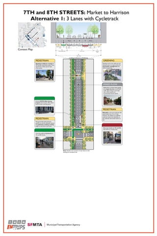
This document summarizes issues and opportunities for improving the Seventh and Eighth Street corridor in San Francisco's South of Market neighborhood. It identifies three segments of the corridor and focuses on the segment between Market and Harrison Streets, which experiences high traffic volumes, speeds, and rates of pedestrian injury collisions. The document outlines the project's objectives to improve pedestrian conditions and safety, reduce crossing distances, and upgrade the public realm and landscaping, particularly on Seventh Street as a designated "green connector" street. Tradeoffs will be required due to the limited right-of-way. Proposed design alternatives aim to balance priorities like pedestrian comfort and traffic flow.
Community Meeting #2 - Folsom & Howard Streets Alternatives
Community Meeting #2 - Folsom & Howard Streets AlternativesEastern Neighborhoods Transportation Implementation Planning Study
Community Meeting #2 - 16th Street Alternatives
Community Meeting #2 - 16th Street AlternativesEastern Neighborhoods Transportation Implementation Planning Study
More Related Content
Viewers also liked
Draft proposal
This document proposes a plan to increase donations to Sanjiwani by creating a blog about Nepal trekking and marketing it online. The plan is to:
1) Make minor updates to Sanjiwani's existing website.
2) Create a new blog about Nepal trekking and post regular content like videos and articles.
3) Market the blog through paid advertising, YouTube, and articles to attract visitors interested in trekking in Nepal.
4) Ask visitors to sign up for an email series in exchange for donating, with the goal of getting 1,000 daily visitors and then seeking sponsors.
EN TRIPS Existing Conditions Jun 2010
EN TRIPS Existing Conditions Jun 2010Eastern Neighborhoods Transportation Implementation Planning Study
An extensive existing conditions analysis was completed to establish a baseline of current transportation in the EN TRIPS study area.Aug 23, 2010 entrips evaluation presentation.ppt
Aug 23, 2010 entrips evaluation presentation.pptEastern Neighborhoods Transportation Implementation Planning Study
This document outlines an evaluation framework and process for prioritizing transportation projects in Eastern Neighborhoods of San Francisco. It proposes a three-track system that evaluates: 1) major network projects, 2) neighborhood-scale projects, and 3) area-wide policy projects. Both qualitative and quantitative criteria will be used to assess projects according to goals like improving circulation, addressing deficiencies, and aiding street design. A timeline and next steps are discussed for applying this framework.Task 2: EN TRIPS Future Conditions final report jun 2011
Task 2: EN TRIPS Future Conditions final report jun 2011Eastern Neighborhoods Transportation Implementation Planning Study
This document provides an overview of future transportation conditions in San Francisco's Eastern Neighborhoods based on projected population and employment growth between 2005-2035. Key findings include:
- Significant increases in population and employment are projected, especially in the Central Waterfront and Mission Bay areas.
- Total daily trips are projected to increase by over 50% and PM peak period trips to grow by over 40%.
- Vehicle volumes on major streets are expected to rise substantially, potentially worsening congestion.
- Transit ridership is projected to more than double, straining the capacity of key bus and light rail lines.
- Pedestrian collisions may rise in areas with high projected density increases without street improvements. 01.ENTRIPS
The document provides an introduction and background on the EN TRIPS project, which aims to implement the transportation vision established in the Eastern Neighborhoods Area Plans of San Francisco. It discusses the project scope and objectives, which include identifying and designing key transportation infrastructure projects to address impacts of growth in the Eastern Neighborhoods. The objectives call for investing in improved transit, pedestrian, bicycle, and other multimodal facilities to efficiently move people and goods through these neighborhoods as population and employment are forecast to greatly increase. The document also reviews the relevant transportation policies that provide input to the EN TRIPS project.
ENTRIPS Summary of All Priority Corridor Alternatives
ENTRIPS Summary of All Priority Corridor AlternativesEastern Neighborhoods Transportation Implementation Planning Study
This document provides a summary and evaluation of 9 alternatives for improving transit service on 16th Street in San Francisco. The alternatives vary the configuration of transit lanes, bicycle lanes, and other features. They were evaluated on criteria like transit performance, impacts to other modes, cost, and effects on parking and loading. Based on the evaluation, 3 alternatives were identified for further consideration because they balanced priorities well. The best alternative would create a center transitway on 16th Street with bicycle lanes on a parallel street, allowing for strong transit performance while maintaining other features.03.ENTRIPS
This document summarizes transportation issues and opportunities for the Folsom and Howard Street corridor in San Francisco's South of Market neighborhood. It discusses the four distinct segments that make up the corridor and focuses on the segment between 5th and 11th Streets. This segment was prioritized for analysis due to expected growth and community priority. The summary identifies key challenges including limited pedestrian facilities, high vehicle volumes and speeds that diminish safety, and a lack of protected bicycle facilities. Project objectives are outlined to improve pedestrian safety and connectivity, enhance the public realm, improve transit legibility, maintain adequate vehicle capacity while prioritizing other modes, and deliver cost-effective improvements. A framework is proposed for east-west circulation in the area with Mission
Keynote commodity daily report 191011
The document summarizes daily commodity outlooks for gold, silver, and crude on the MCX exchange. On the day, gold ended with modest losses while silver and crude ended with modest gains. Technical indicators like RSI and stochastic signals suggest selling pressure for gold and buying support for silver and crude. Key resistance and support levels are provided. The US economic calendar for the coming week is also summarized.
Leon andres el papi ocampo
El amor es un sentimiento especial que no distingue raza y es igual para todos, además es muy lindo para quien sabe amar.
Assignment 1 b
This document outlines a group project assignment for a course on the construction industry. The objectives are to understand construction team roles and responsibilities and appreciate various professions. Students must interview a professional from the construction industry, research their role and two projects. They will then create an 8-12 page magazine detailing the professional's company, profile, roles and project descriptions. Submissions include an interview recording and magazine PDF. A peer assessment evaluates each member's contributions and ranks their performance.
Viewers also liked (17)
Task 2: EN TRIPS Future Conditions final report jun 2011
Task 2: EN TRIPS Future Conditions final report jun 2011
ENTRIPS Summary of All Priority Corridor Alternatives
ENTRIPS Summary of All Priority Corridor Alternatives
More from Eastern Neighborhoods Transportation Implementation Planning Study
Summary of full list of project allternatives entrips
Summary of full list of project allternatives entripsEastern Neighborhoods Transportation Implementation Planning Study
The document presents 9 alternatives for improving transit on 16th Street in San Francisco. All alternatives provide dedicated transit lanes and priority treatments. They differ in placement of bicycle facilities, type of transit lane, and location of bus stops. Alternative 1 provides the strongest transit performance with a center transitway and improved bicycle corridor on 17th Street. It was carried forward for further evaluation. Alternative 4 also provides a center "queue jump" lane for transit and was also carried forward.02.ENTRIPS
This document summarizes the key issues and opportunities related to transportation along the 16th Street corridor in San Francisco. It discusses four distinct segments of 16th Street and identifies the segment between Potrero Avenue and 7th Street as the focus of the ENTRIPS corridor design project due to expected growth, congestion forecasts, transit constraints, and community priority. The objectives of transportation improvements for this segment are outlined, including prioritizing transit performance, enhancing the public realm, improving pedestrian and bicycle conditions, maintaining vehicle circulation, and delivering projects cost-effectively. Finally, nine project alternatives are presented and evaluated against the objectives.
04.ENTRIPS
This document summarizes issues and opportunities for improving the Seventh and Eighth Street corridor in San Francisco's South of Market neighborhood. It identifies three segments of the corridor and focuses on the segment between Market and Harrison Streets, which experiences high traffic volumes, speeds, and rates of pedestrian injury collisions. The document outlines the project's objectives to improve pedestrian conditions and safety, reduce crossing distances, and upgrade the public realm and landscaping, particularly on Seventh Street as a designated "green connector" street. Tradeoffs will be required due to the limited right-of-way. Proposed design alternatives aim to balance priorities like pedestrian comfort and traffic flow.
Community Meeting #2 - Folsom & Howard Streets Alternatives
Community Meeting #2 - Folsom & Howard Streets AlternativesEastern Neighborhoods Transportation Implementation Planning Study
Community Meeting #2 - 16th Street Alternatives
Community Meeting #2 - 16th Street AlternativesEastern Neighborhoods Transportation Implementation Planning Study
Task 3.b: EN TRIPS Priority Corridors - Preliminary Street Redesign Alternat...
Task 3.b: EN TRIPS Priority Corridors - Preliminary Street Redesign Alternat...Eastern Neighborhoods Transportation Implementation Planning Study
This memorandum provides descriptions and analysis of concept alternatives developed for transportation projects on Folsom and Howard Streets and Seventh and Eighth Streets in San Francisco's South of Market neighborhood. Ten alternatives were initially considered. For Folsom and Howard, alternatives 1, 6, and 9 were recommended for further consideration. Alternative 1 would convert the streets to a two-lane, one-way configuration with cycletracks. Alternative 6 would implement a hybrid one-way/two-way configuration. Alternative 9 would convert the streets to a two-lane, two-way configuration with buffered bike lanes. The alternatives aim to improve safety and comfort for pedestrians and cyclists while maintaining adequate vehicle capacity and access for businesses.Feb 2, 2011 Community Meeting Comment Boards
Feb 2, 2011 Community Meeting Comment BoardsEastern Neighborhoods Transportation Implementation Planning Study
These boards are those we shared during the Community Meeting, with the notes and "voting" as marked up by community members.EN TRIPS Community Presentation Feb 2011
EN TRIPS Community Presentation Feb 2011Eastern Neighborhoods Transportation Implementation Planning Study
At the Feb. 2, 2011 Community Meeting, the EN TRIPS consultant team identified preliminary priority corridors, and asked the community for their feedback. More from Eastern Neighborhoods Transportation Implementation Planning Study (8)
Summary of full list of project allternatives entrips
Summary of full list of project allternatives entrips
Community Meeting #2 - Folsom & Howard Streets Alternatives
Community Meeting #2 - Folsom & Howard Streets Alternatives
Task 3.b: EN TRIPS Priority Corridors - Preliminary Street Redesign Alternat...
Task 3.b: EN TRIPS Priority Corridors - Preliminary Street Redesign Alternat...