
Recommended
More Related Content
What's hot
What's hot (20)
Viewers also liked
Viewers also liked (15)
Similar to canada
Similar to canada (20)
canada
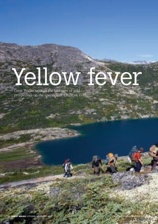
- 1. Yellow feverGreat Walks retraces the footsteps of gold prospectors on the spectacular Chilkoot Trail. 16 | GREAT WALKS OCTOBER_NOVEMBER 2015 AUSTRALIA’S BUSHWALKING MAGAZINE
- 2. WORDS AND PHOTOS_ MARK DAFFEY GREAT GOLD RUSH WALKS CHILKOOT TRAIL, USA/CANADA OCTOBER_NOVEMBER 2015 GREAT WALKS | 17WWW.GREATWALKS.COM.AU Hikers on the Chilkoot Trail above Long Lake.
- 3. I n 1896, gold prospectors George Carmack and ‘Skookum’ Jim Mason struck it rich at Bonanza Creek, in Canada’s Yukon region. They initially kept their find quiet, extracting whatever they could get their hands on. But the moment the news leaked, all hell broke loose. The newspapers carried the story as their lead headline and soon after every man and his dog had caught yellow fever. Low employment levels at the time forced tradesmen, labourers, dentists, prostitutes and conmen to load up their wagons and head north to the Klondike goldfields to try their luck. It was a long and arduous journey – 2,575km – and all but one small section between the port of Seattle and the Yukon’s Dawson City was traversable by sea, lake or river. More than any other, this 53km overland leg came to symbolise the hardships prospectors faced in their scramble for riches. A coastal mountain range formed a barrier between the Alaskan port of Skagway and the Yukon River hub of Whitehorse. To get from one to the other prospectors had to traverse the Chilkoot Trail – a timeworn trading route controlled by First Nations tribes – on foot. In July 2015, World Expeditions added the Chilkoot Trail to their global trekking inventory, retracing the historical route over a five-day hike. The altitudes reached aren’t particularly high and the days aren’t overly long, and yet World Expeditions still rates the hike as ‘moderate to challenging’. The reason for that categorisation is that participants are required to carry a full pack. Porters are hired to lug tents and food from camp to camp, and you cart everything else. “Be bold, start cold” On our first morning, we drive from Whitehorse to Fraser then catch the scenic White Pass & Yukon Railway to Skagway, the Alaskan port town servicing the Inside Passage cruise industry. It’s already 4pm when we reach the trailhead in Dyea, Alaska, but it’s mid-summer and we’re 60° north of the Equator. In these parts, and at this time of year, there’s almost 24 hours of daylight, so there’s zero concern about reaching camp after dark. The 16°C temperatures are hardly very summery though. Nevertheless, our effervescent guide, Vanessa Stewart, urges us to “be bold, start cold,” adding that we could expect “a bit of up and down, so it won’t be long before you’re stripping the layers off.” We spend that day and the next hiking through temperate rainforest beside the frenzied flow of the Taiya River. It’s cloudy overhead and damp underfoot, and rain drizzles incessantly. I ask Stewart if leeches are a problem here. “Leeches? Here? No way!” she barks, adding. “Well, not that I’ve ever found.” There are no snakes or spiders either. And even the bities that routinely plague Northern Canada and Alaska over the summer months barely register in these parts. 18 | GREAT WALKS OCTOBER_NOVEMBER 2015 AUSTRALIA’S BUSHWALKING MAGAZINE
- 4. But there are nasties in this region, and they’re much bigger and scarier than those that suck your blood or inject you with poison. Bears – blacks and fearsome grizzlies – roam these woods, and they’ve been known to startle trekkers on plenty of occasions. More often though, bear encounters take place around campsites, where the sweet smell of food appeals to their sense of smell. For that reason, we’re advised never to leave our packs unattended. We’re also told to lock all food and toiletries in metal, tamper-proof lockers called ‘bear bins’. It’s our first task upon reaching camp. Squirrels, scales and scrambling Over the next few days our run-ins with bears are thankfully limited to bedtime stories and observation reports filled out by others. Squirrels make up the majority of our wildlife encounters, OCTOBER_NOVEMBER 2015 GREAT WALKS | 19WWW.GREATWALKS.COM.AU Walk notes CHILKOOT TRAIL, USA-CANADA Time/distance: 7 days/53km | Grade: moderate-challenging Walknotes Day 1: Whitehorse Day 2: Finnegan’s Point – 7.9km/ 3-4 hours) Day 3: Sheep Camp – 13km/6-7hr Day 4: Chilkoot Pass and Happy Camp – 12km/8-11hr Day 5: Lake Lindeman – 8.8km/4-5hr Day 6: Lake Bennett – 11.3km/4-5hr Day 7: Whitehorse CANADA GREAT GOLD RUSH WALKS CHILKOOT TRAIL, USA/CANADA Bennett-Whitehorse floatplane over Bennett Lake. BELOW: Chilkoot Trail hikers on a Beaver Pond boardwalk in Alaska. BELOW LEFT: Canyon City warming shelter, Alaska.
- 5. 20 | GREAT WALKS OCTOBER_NOVEMBER 2015 AUSTRALIA’S BUSHWALKING MAGAZINE and artefacts left behind and consciously preserved from the gold rush days are more common sightings. There are shovels and boots and metal wagon wheels. On our second morning, we cross the gushing river via a swing bridge to investigate a truck-sized boiler used to power a freight tramway to the top of the Chilkoot Pass. Later, we find a rusty old sled resting beside Lindeman Lake, on the Canadian side of the trail. Stampeders – as prospectors were called – considered it safer and easier to make the trek to the Klondike during the harsh winter season, when rivers and lakes would freeze and act as proxy highways to the goldfields. Still, many who joined the convoy were woefully unprepared for the conditions and the North West Mounted Police, or Mounties, insisted that every person who entered Canada via the pass carry a year’s worth of food supplies, on top of the tents, cookware and prospecting tools they carted up. Failure to do that risked being turned back. Goods were weighed at the foot of the pass, at a place that came to be known as The Scales, and it was this last steep climb to the summit that became the stuff of legend. It would take stampeders around 40 trips before they’d hauled all their goods to the top of the pass. And each time they returned to The Scales, they would have to wait their turn to do it all again. Yet even that didn’t stop the flow of goods over the pass. Some 13,000 stampeders crossed between mid-February and May 1898, carrying supplies with an estimated value of more than $100 million – 10 times the amount of gold that was eventually found in the Yukon. Included in that inventory was a baby piano and a steamship that was dismantled piece by piece then reassembled soon after it had crossed the Canadian border. Steps were cut into the ice from The Scales to the pass back then, forming a passageway that came to be known as the Golden Stairs. Being summer, we had no such luxury. Ahead of us lay a steep
- 6. OCTOBER_NOVEMBER 2015 GREAT WALKS | 21WWW.GREATWALKS.COM.AU boulder field that we’d have to pick our way through all the way to the top. The rocks were slippery and there was no obvious route. At times, we were forced to scramble up on all fours. Natural beauty The Chilkoot Pass marks the border between the United States and Canada, and the terrain changes dramatically thereafter. Exposed boulders and alpine tarns replace the Alaskan rainforests. Wildflowers litter the ground and the valleys open up. We could be hiking through the highlands of Scotland or in central Tasmania. The trail rises and dips over a series of undulations, passing glaciers and streams that form the headwaters of the mighty Yukon River until we reach Happy Camp, at the entrance to a ravine. It has been our longest and most exhausting day of the trek, yet I feel better at the end of it than any other. The sun makes a rare, lingering appearance on our fourth morning, showcasing nature’s wondrous pallet. The trail skirts the turquoise waters of Long Lake then Deep Lake, and we descend steadily into the dry boreal forest found across the Yukon. There’s more downhill than up and the river steadily gains force, plunging over waterfalls and ploughing through rapids. On our last night, we camp on the sandy shores of Lindeman Lake, where most of us choose to strip down to our underwear for an invigorating swim. It’s our first wash in days, perhaps explaining why the bears have kept their distance. At the height of the gold rush, Lindeman City housed 40,000 stampeders. The surrounding forest was stripped of timber to build boats and buildings and for many, this was the point where their journey on foot ended. They could float across the lakes and down the river from here, all the way to Dawson City. Most continued on to Bennett, however, for between the two lakes lies a mile of rapids. GREAT GOLD RUSH WALKS CHILKOOT TRAIL, USA/CANADA Chilkoot Trail hikers near The Scales.
- 7. 22 | GREAT WALKS OCTOBER_NOVEMBER 2015 AUSTRALIA’S BUSHWALKING MAGAZINE There’s no such obstacle for us. Most of our last day’s hike is over exposed rocks, save for a 20-minute slog through a section of the trail Stewart describes as the “sand from hell”. It’s tough going over that last section, as our boots sink and the ground shifts beneath our feet. We arrive at Bennett at 2.30pm. It’s just enough time to prepare a quick lunch before our chartered floatplanes touch down on the lake, ready to take us back to Whitehorse. The alternative is to jump aboard the White Pass & Yukon Route railway service back to Skagway, which ironically marked the end for the Chilkoot Trail route when it commenced operations in July 1899. Freight traffic over the Chilkoot Pass disappeared almost overnight. Lindeman City was deserted by 1900, and Bennett two years later. By then the gold rush was running out of steam. After months of arduous travel through snow and over mountains, the only discovery most stampeders made was that they were too late. The best claims had been staked. Like us, by the time they arrived in Whitehorse, they may as well have gone home. Great Walks was a guest of Destination Canada and World Expeditions. NEED TO KNOW Getting there Air Canada fly direct from Sydney to Vancouver. In 2016, they will launch an additional direct service from Brisbane. From Vancouver, it's a two-hour flight to Whitehorse on Yukon's airline, Air North (www.flyairnorth.com). Best time to go World Expeditions’ seven-day Chilkoot Trail retraces the stampeders' route over the Chilkoot Pass in the scenically stunning Alaska and British Columbia before finishing in Whitehorse, Yukon. Cost is $2,990 per person, excluding international airfares. In 2015, there was only one departure, in July. For 2016 departures and for further information, look up www.worldexpeditions.com or call 1300 720 000. Gear to take You’ll be carrying all your own gear on your back, bar tents and food. Wear hiking boots that are suitable for walking through snow and crossing creeks. i GREAT GOLD RUSH WALKS CHILKOOT TRAIL, USA/CANADA Hikers on the Long Hill to the Chilkoot Pass.