The document proposes a design for a civic center called El Centro in Altamonte Springs, Florida. It aims to enhance the area surrounding the city's future Sunrail transit station. The design emphasizes civic values and pride through its branding and orientation around the transit core. It analyzes the site and surrounding area to inform a master plan that connects regional activity centers and identifies opportunities for increased density. The plan proposes transforming nearby roads into more pedestrian-friendly boulevards. It also suggests a phased development approach through public and private investments, including improving the transit hub, adding a parking garage, and mixed-use development including a community center focusing on urban agriculture at the historic Rife site. The goal is to establish El Cent
The document provides a site analysis of an area in Ajman, UAE. It summarizes the location and surrounding transportation access. It then analyzes various aspects of the site planning including primary winds, sunlight exposure, road networks and hierarchy, pedestrian accessibility, zoning, mass and void spaces, and ethnic neighborhoods. It also describes some of the existing landmarks, the local architecture styles, and opportunities for development and restoration of heritage sites. The analysis provides details to understand the urban planning and land use of the area.
The document summarizes an Ontario East Municipal Conference presentation on Highway Corridor Management 101 by the Ministry of Transportation. The presentation covers topics such as relevant legislation, corridor management organization and structure, the ministry's interest in municipal land use planning along highway corridors, and current issues. The goal of corridor management is to ensure safety, efficiency and future expansion of highway corridors by managing access points and development along highways.
This document provides an overview of a capstone project focused on urban revitalization in Siloam Springs, Arkansas. It discusses the need for urban revitalization due to past urban abandonment. It then summarizes the existing conditions and population in Siloam Springs. Diagrams and sectional studies of Twin Springs Park are presented showing how the design recommendations would enhance the park and celebrate the natural elements, improve pedestrian and vehicular experiences, and help create a more walkable and vibrant downtown that preserves the culture and history of Siloam Springs.
The Detroit Strategic Framework is a plan to guide Detroit's future over multiple decades. It was created through an extensive two-year public engagement process involving Detroit residents, civic leaders, technical experts, and community organizations. The plan establishes a shared vision and specific strategies to create a more prosperous, equitable and sustainable Detroit through approaches that are aspirational, practical, respectful of the city's history and inclusive of community voices. It aims to address Detroit's challenges through coordinated efforts across sectors that leverage the city's significant assets such as its industrial heritage, cultural institutions and engaged residents.
Silver Spring future development and art influence depends of visionaries citizens. This presentation serves as a explorative window of new real estate trends, cultural and economic sensitive development and how we move forward an agenda of continuum progress.
Presentation for the SILVER SPRING ARTS & ENTERTAINMENT ADVISORY COMMITTEE.
The document discusses a survey of 50 people in Bangkok that found 80% said they felt stress. The most popular activities for relieving stress were watching movies or TV (62.5%), listening to music (12.5%), eating out (10%), and sleeping (5%). It also provides case studies of two spa facilities - Paracelsus Spa and Pools in Salzburg, Austria, which has 7 pools and covers 14,000 square meters, and Thermal Vals in Switzerland, designed by Peter Zumthor, which covers 60,000 square meters and provides a sensory bathing experience through its use of light, water and stone.
The document discusses infrastructure, laws, and regulations relevant to a development site. It provides a catchment diagram showing amenities within 1km of the site like hospitals, schools, temples, and transportation. Building regulations specify setback distances from roads, railroads, dams, and rapid transit stations. The zoning defines permitted land uses like residential, commercial, and government areas. Development standards require minimum road widths or proximity to subway stations depending on the land use and size.
Phase I of the proposed development focuses on low-cost pavement markings and signs to improve pedestrian and bicyclist safety. This includes painted sidewalk extensions, parking meters, crosswalk markings, and shared lane markings. Phase II introduces park amenities like seating and art while maintaining traffic flows. Phase III connects the concrete islands to fully close one street, allowing expansion of green space. A stage and gathering area are also proposed to transform the area into an urban park serving the community.
This draft document implement the strategies in this TDDP by encouraging design excellence and the creation of a safe pedestrian environment and attractive gathering places.
This technical report proposes an alternative solution to replacing street lights on Belcrest Road in Prince George's County. It identifies issues with the Department of Public Works' proposal to use standard cobra-head street lights spaced at 150 feet. The alternative proposes a three-phase program: 1) Install new two-headed street lights and conduits every 100 feet while adding a new sidewalk; 2) Add infill lights every 50 feet for continuous lighting; 3) Retrofit the sidewalk as development occurs to include a separated cycle track along with new development standards. The goal is to provide safe lighting for increased pedestrian and bicycle activity along this important corridor.
This document summarizes the analysis and recommendations of staff from the Maryland-National Capital Park and Planning Commission regarding potential relocation sites for Gold's Gym within the Largo Town Center area of Prince George's County, Maryland. Staff evaluated two prominent sites within the Largo Town Center Sector Plan boundaries that could accommodate Gold's Gym's facilities and vision to help implement the goals of creating a walkable, healthy downtown environment as outlined in the county's general plan.
This document provides a proposed design for a multipurpose plaza located on 15th Avenue. The plaza would include a 20-foot wide fountain, benches, a 10-foot wide communal stage, and gardens spaced 10 feet wide along the perimeter. The design is part of a draft application to the Langley Park Community Legacy program seeking funding for improvements in Prince George's County, Maryland.
The document is a draft community legacy application for Langley Park submitted to Prince George's Community Planning Division on June 3, 2014. It requests funding to support revitalization efforts and improvements in Langley Park such as upgrading infrastructure, beautifying public spaces, and supporting local businesses and community groups. The application aims to secure funding that will help Langley Park become a more attractive, safe, and vibrant community for residents and businesses.
Design Guidelines for the Town of Upper Marlboro. This project was created in order to improve the quality of the public realm of the town, along with guidelines for facades improvements.
This document discusses the art of placemaking and its importance for Prince George's County's future. It outlines how current development has focused on cars, leading to sprawling suburbs and isolated civic buildings and shopping centers. However, demographic trends show residents want more walkable, urban communities. Placemaking is defined as a community-driven, visionary process to create public spaces that bring people together and connect the past and present. The document advocates for more multimodal transportation options and human-centric development, with diverse public spaces like parks and trails, to build livelier, socially inclusive communities and improve quality of life. The highest art of placemaking will help Prince George's County achieve its vision for 2035 of thriving, safe,
The document discusses recommendations for developing the Silver Spring Central Business District in Maryland into a mixed-use cultural district that attracts people through various land uses and public amenities. It recommends market-oriented commercial and residential development, including new housing types, to create an active place with activity at all times. County investment is seen as essential to establishing the downtown as a center for community. The area's demographic trends include urban-dwelling generations X and millennials, with an active lifestyle oriented around urban recreational amenities.
The document summarizes information about civic places in Silver Spring, Maryland, including descriptions of different parks and public spaces, stakeholders, demographic trends of residents, and opportunities for placemaking. It discusses how placemaking can create destinations and socially inclusive public spaces to foster community participation.
The purpose of this assessment is to deliver a description of the current and proposed urban squares, neighborhood parks, plazas and garden in Silver Spring.
The document discusses lessons learned from other rail systems that could benefit Winter Park's SunRail station. These include:
1) Transportation authorities must adapt plans to voter demands without losing long-term vision, like Austin scaling back ambitious plans.
2) Offering amenities for bicyclists like bike lockers and racks on trains and buses, despite weather concerns.
3) Providing amenities for riders such as free Wi-Fi on trains.
4) Attracting "choice riders" or those who choose to take transit despite having other options, in order to significantly reduce traffic congestion.
Market Square aims to revitalize the failed Fashion Square Mall site through placemaking principles. It seeks to reconnect the site to the surrounding communities of Audubon Park and Baldwin Park by making the area more pedestrian-friendly and introducing mixed-use development with housing, offices, retail, and community spaces. The project emphasizes creating a sense of community through hosting public events celebrating local food, arts, and bike culture to bring people together.
This report provides recommendations for transforming the Wells District area of Orlando into a creative village. It discusses precedents like Portland, Oregon which has successfully created vibrant third places through interconnected green spaces, mixed uses, and high walkability. The recommendations focus on incorporating history, greenspaces, connectivity between different modes of transportation, mixed income housing, retail/commercial spaces, and a hotel to develop Wells District into a true live, work, play urban destination.
1. The document analyzes a figure ground map of development along Morse Boulevard in Winter Park, Florida.
2. It finds that development is more dispersed and lacks a consistent building line from Pennsylvania Ave to Virginia Ave, discouraging walkability.
3. From Virginia Ave to New York Ave, density is better but apartments do not address the street, while newer mixed-use development from New York Ave to Park Ave is more walkable.
4. Overall, there are opportunities to improve walkability and connectivity through infill development and addressing the streetscape.
This document presents a plan for development in Maitland, Florida focused around improving connectivity to a new SunRail station. It proposes mixed-use and high-density residential developments within walking distance of the station, emphasizing pedestrian access and public spaces. Conceptual plans and statistics are provided for multiple development sites, showing numbers of residential units and parking spaces. The goal is to create an active, walkable transit-oriented community around the SunRail station.
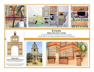
1. El Centro
Altamonte Civic Center
A Demonstration of Altamonte’s Civic Values
Dedicated to the great people of Altamonte Springs
Altamonte
Transit Oriented Development
Planned and Designed by
Jose Carlos Ayala |Sarah Elbadri
Travis Ray|Heather Tribou
2. Designing Altamonte Civic Center
Enhancing Current Conditions
Given the current conditions
surrounding Altamonte Springs’
future Sunrail Station, within its
half-mile transit neighborhood
and especially its quarter-mile
transit core, it was clear that
one of the main goals of this
project would be to not only
create a sense of place, but
also re-establish and invigorate
Altamonte’s sense of civic pride.
Just west of the site, across
Ronald Reagan Boulevard,
Altamonte Springs City Hall,
Police Department, and Fire
Station #11 sit, nestled in
between a water treatment
facility and several, under-utilized
parking lots.
While lacking a clear sense of
esteem for government, this site
provides a strong foundation for
2
a future civic center.
3. Branding
Emphasizing Civic Ideals
Altamonte City Hall
This building’s non-descript architecture
resorts to an over-sized font to define its use.
Respecting civic features of Altmonte Springs’ current logo, the logo design of El Centro,
Altmonte’s civic center and seat of government, induces a feeling civic participation and
grounded government.
The crane, reminescent of Crane’s Roost is removed, and focus is shifted to civic
engagment, represented by the central feature at the apex of the design. Taking cues Current City Branding
from Capitoline, Rome, this logo reminds government and its citizens that collaboration Altamonte employs a central architectural
structure feauring an Atlas-like globe held up
and partnerships are what move civil society forward. This theme is found throughout El
by citizens, along with a crane, which acts as
3
Centro, in both its design ethos and physical manifestation.
the city’s “mascot”.
4. Orientation
Emphasis on Transit Core and Neighborhood
El Centro is located at the
intersection of State Road 436
and Ronald Reagan Boulevard.
Because of its orienation around
Altamonte’s SunRail Station, a
great emphasis was placed on
what FDOT’s TOD language calls
the “transit core” and surrounding
“transit neighborhood.”
In order to model the best-suited
program for this site, GIS studies
4 were employed to analyze the
area.
5. Site Analysis NON-RESIDENTIAL
Intensity
Non-residential uses
are oriented around
major thoroughfares
GIS Studies in the area. Ronald
Reagan Blvd and
436 are significant corridors of non-
residential activity.
RESIDENTIAL Intensity
NON-RESIDENTIAL Intensity
Dwelling units are
found behind the
commerical activity
RESIDENTIAL Intensity
corridors.
POPULATION
Distribution
Higher population
densities are found
at least one block
away from major
thoroughfares. The
greatest density is found in the SW
corner of the study area, due to a
POPULATION Distribution
concentration of multifamily units.
VACANT Land
Undeveloped
parcels are scattered
VACANT Land
throughout the
site, but are mostly
concentrated in
the north- and east-
side of the study area. A significant
amount of this vacant land is found 5
in the transit core.
6. Master Planning
Considering the Regional Context
This Master Plan is the end result
of a three-step analysis that
sought to transform the transit
core and transit neighborhood
into regional centers of activity
and connectivity. These steps
are modeled after Galina
Tachieva’s approach to
identifying sites for sprawl repair
and increased density.
1. Preserve wetlands,
agriculture, and park lands
2. Preserve historical, cultural,
civic centers
3. Identify areas of employment
Following these steps,
connections were then
6 identified and areas for
densification planned.
7. Master Planning Preserve
GREENSPACES
Wetlands, historically
agricultural lands,
and parks are
Making Connections preserved for
recreational and
environmental needs.
Preserve CIVIC
CENTERS
Preserve CVIC CENTERS
Preserve GREENSPACES
Schools, churches,
community
centers, and an
African-American
neighborhood are
the main civic centers in the area.
Identify EMPLOYMENT
The corridor around
SR-436 is a major
employment hub. A
secondary node is
found north of 436
along the west-side
of Ronald Reagan Boulevard.
CONNECT and DENSIFY
Identify EMPLOYMENT
CONNECT and
DENSIFY
These centers
of activity are
connected.
Opportunities for
density are then
identified and planned for in the
final master plan 7
8. Designing Better Connectivity
Enhancing Links
State Road 436, the major thoroughfare running east-west
through the site, is not just an auto-oriented road but an auto-
dominated arterial. In order to create a more pedestrian-
oriented experience, 436 must be civilized.
A boulevard design is proposed, transforming the 6-lane highway into a 4-lane center thoroughfare for
higher speed traffic, and two one-way side streets for local and multimodal traffic.
For an optimal pedestrian environment, 10ft sidewalks with 10 ft landscape buffers are suggested. This
neccesitates a 10ft easement for each side of SR-436. A similar design is proposed for Ronald Reagan
8 Boulevard.
9. Old Urbanism
The Streetcar Revisited
Connecting the dots
El Centro seeks to act as connection
between regional nodes of activity.
Bicycle connectivity
While exisiting (green) connections exist,
boulevarding (red) adds major east-west and
north connections.
Missing connectivity and
increased access are
provided by a proposed
streetcar line. The streetcar
provides a traffic-free route
to the mall (1) and hospital Bus Connectivity
(2) west, just north of SR-436, Four current routes (1, 41, 102, 103) in the
9
and a much needed commuter route from a neighborhood-center northeast of El Centro. area will become part of the on-site bus hub.
10. Phasing Altamonte Civic Center
Investments and Partnerships
2
This site-specific plan of El
6 Centro utilizes public investment
and private-public partnerships
for a successful phased build-
5 5 out.
4
Major features of this plan
3 include
1. improved bus hub
2. parking garage
3. mixed-use development
4. pedestrian plaza
1
5. mirrored civic centers
-governmental center
-platform based third-
space
6. quasi-public community
center (Rife evelopment)
10
11. Phasing Phase 1
The station features
about 350 parking
spots and a bus
hub.
Logistics and Style
Phase 2
Villa Vizcaya, a famous example of Mediterranean revival “One of the
architecture, is located greatest design
in Miami.
flaws of a station
configuration is
to surround it with
parking and noisy
bus areas.” Peter
Calthorpe,
The Mediterranean
Revival style The Next American
Riverside
Baptist Church
Metropolis
(1924-1925)
was the
only church The bus hub
designed
by famed
is moved and
Palm Beach oriented toward the east platform. The city
Architect Addison
Pasadena City Hall Mizner. invests in a parking garage, serving as an
was designed by incentive for private development.
John Bakewell &
Arthur Brown who
were influenced
by the early Vinoy Park Hotel
Renaissance style in downtown St.
Petersburg FL
Phase 3
of 16th century
Italian architect opened in 1925. Private
Andrea Palladio.
Construction was
development
completed on takes advantage of
December 27, 1927.
the parking garage
and adds mixed
use development
to the site. A public-
private partnership
Phase 4 is formalized and
Reconstruction of City Hall begins. This completes the other half of the El Centro jointly constructs the
development. The suggested architectural style for this site is Mediterranean Revival, with central pedestrian
regional examples from Florida and a city hall example from Pasadena, CA. plaza.
11
12. Community in the Civic Center
Rife Development
Like the site itself, development within
El Centro has the potential to create a
unique node of activity with a distinctive
experience exclusive to its environment.
The Rife Site, just east of City Hall, has
the ability to leverage not only its nearness to a major SunRail station, but also its
relationship to the civic center. As a community center, with a focus on urban
agriculture and local food, it has the capacity to draw people to Altamonte
as an experience-based destination. With initially simple design changes, and
12 futher phased renovations, the Rife Site could celebrate the rustic revival of local
economies.
13. Phasing
Architectural and Stuctural
Phase 1: Architectural Changes
Transforming the face of the Rife post office
Phase 2: Structural Additions with a brick and steel facade will set off the
Restaurant space is a profitable and rustic feel of the building. Large windows
appropriate use for this site, which is close to fronting Ronald Reagan Boulevard invite
both transit and employment. Inspiration for both pedestrians and drivers to peak into the
this structure comes from Emril’s on Universal activity happening inside the the building.
City Walk. While a tourist attraction near
the theme parks, this structure serves
as landmark for the site and grounds
the original Rife building. With a menu
focused on local food, the restaurant
is likely to attract “foodies” throughout
Central Florida (especially those living
near the SunRail spine).
With the addition of a raised outdoor
patio, similar to
Winter Park’s
Farmers Market, this Adding Prato-like folding glass doors facing
site becomes ideal the interior of the site (and future pedestiran
for programming plaza) also add to an indoor-outdoor flexbility
ranging from to the space.
weddings to art
shows, to gardening A side patio with a seating
demonstrations. wall and garden boxes
present a casual feel.
By creating this
quasi-public
place, it extends
Phase 3: Residential Construction the Rife building
The final addtion of artists’ lofts complements the culture of beyond its site,
the site and adds residents to El Centro. into the adjacent 13
street life.