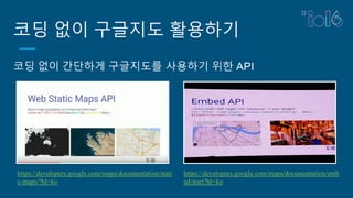
코딩 없이 구글지도활용하기
코딩 없이 간단하게 구글지도를 사용하기 위한 API
https://developers.google.com/maps/documentation/stati
c-maps/?hl=ko
https://developers.google.com/maps/documentation/emb
ed/start?hl=ko
Directions API(길찾기)
▪ 자동차,도보, 자전거 등 여러
이동 모드에 대한 찾아가는 길
을 검색할 수 있음.
▪ 텍스트 문자열로 지정하거나
위도/경도 좌표로 지정할 수 있
음.
▪ 경유지를 사용하여 여러 찾아
가는 길을 반환할 수 있음.
▪ 결과 값은 JSON/XML 형태로
반환 됨.
17.
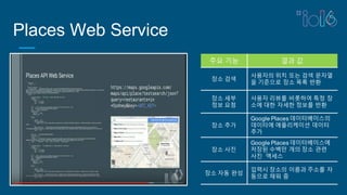
Places Web Service
주요기능 결과 값
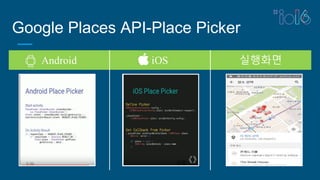
장소 검색
사용자의 위치 또는 검색 문자열
을 기준으로 장소 목록 반환
장소 세부
정보 요청
사용자 리뷰를 비롯하여 특정 장
소에 대한 자세한 정보를 반환
장소 추가
Google Places 데이터베이스의
데이터에 애플리케이션 데이터
추가
장소 사진
Google Places 데이터베이스에
저장된 수백만 개의 장소 관련
사진 액세스
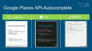
장소 자동 완성
입력시 장소의 이름과 주소를 자
동으로 채워 줌
Google Maps API관련 샘플
Google Maps API Libraries
http://googlemaps.github.io/libraries
Google Maps API 예제 소스
https://github.com/googlemaps/android-maps-utils
https://github.com/googlemaps/android-samples
https://github.com/googlemaps/roads-api-samples
Android AutoCompete/Place API 예제 소스
https://github.com/googlesamples/android-play-places
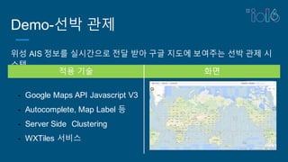
Demo-선박 관제
위성 AIS정보를 실시간으로 전달 받아 구글 지도에 보여주는 선박 관제 시
스템
적용 기술 화면
- Google Maps API Javascript V3
- Autocomplete, Map Label 등
- Server Side Clustering
- WXTiles 서비스
22.
Demo-항공 관제
항공 정보를실시간으로 구글 지도에 보여주는 항공 관제시스템
적용 기술 화면
- Google Maps API Javascript V3
- SuperMap GIS 웹 서버
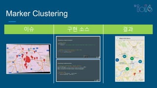
- Marker Clustering
23.
+Kuntaek Jung
Get started:g.co/codelabs/IO16
Questions: help@sphinfo.co.kr
Docs: developers.google.com/maps
Video: https://youtu.be/WJY2tGVQDGQ


![[ 구글맵스엔진 세미나 자료 1/3 ] Google의 Geo 제품군 소개 및 발전방향](https://cdn.slidesharecdn.com/ss_thumbnails/1geov1-140414005954-phpapp01-thumbnail.jpg?width=640&height=640&fit=bounds)


![[ 구글맵스엔진 세미나 자료 3/3 ] Maps for everyone](https://cdn.slidesharecdn.com/ss_thumbnails/3mapsforeveryonev1-140414005838-phpapp01-thumbnail.jpg?width=640&height=640&fit=bounds)


![[ 구글맵스엔진 세미나 자료 2/3 ] 기업에서의 GIS 활용사례](https://cdn.slidesharecdn.com/ss_thumbnails/2gisv1-140414010053-phpapp01-thumbnail.jpg?width=640&height=640&fit=bounds)


