1. 26 Richardson Street West Perth Western Australia 6005
Tel +61 (8) 6454 6666 Facsimile +61 (8) 6454 6667
Email info@impactminerals.com.au www.impactminerals.com.au
ASX ANNOUNCEMENT Date: 23rd January 2015
Number: 390/230115
FURTHER HIGH GRADE PGE-COPPER-NICKEL ASSAYS RETURNED AT THE
RED HILL PROSPECT, BROKEN HILL
Assays from diamond drill hole RHD006 from Impact Minerals Limited’s (ASX:IPT) maiden drill
programme at the Red Hill Prospect near Broken Hill in New South Wales, have confirmed the
discovery of a near surface 25 metre thick zone of mineralisation that contains high grade Platinum
Group Metals (PGM) together with nickel and copper (Figure 1, Tables 1 and 2).
The new assays define an Upper and Lower Zone of mineralisation that returned:
Upper Zone: 5.2 m at 1.1% copper, 1.6% nickel, 3.4 g/t Pt-Pd-Au and 7 g/t silver from 54.2 m
Lower Zone: 13.8 m at 1.1% copper, 0.3% nickel, 6.3 g/t Pt-Pd-Au and 10 g/t silver from 63.2 m
within a broader intercept of bulk mineable width of:
25.5 m at 0.8% copper, 0.6% nickel, 4.3 g/t Pt+Pd+Au and 7 g/t silver from 52.0 m down hole.
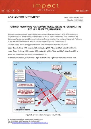
Figure 1. Cross Section along Line 555,370 mE.
Figure 1. Cross Section along Line 555,370 mE.
2. The newly discovered mineralisation in RHD006, which includes a 0.5 m wide
zone of massive sulphide with nickel and copper sulphides (Figure 2) occurs
above the recently reported high-grade copper-nickel-platinum group element
(PGE) mineralisation from RHD001 that returned an intercept of:
32 metres at 1% copper, 0.5% nickel, 3.9 g/t Pt+Pd+Au and 10.6 g/t silver
from 46 m down hole (Table 1).
Within this intercept in RHD001 there are three higher grade zones of veins
and breccias, two of which can be correlated with the mineralised zones in
RHD006 (Figure 2 and announcement dated 17th
December 2014).
The two zones in RHD001 returned best intercepts of:
Upper Zone: 5.1 m at 1.9% copper, 0.9% nickel, 6.2 g/t Pt-Pd-Au and 18 g/t
silver from 57. 3 m.
Lower Zone: 4.2 m at 2.6% copper, 0.5% nickel 10.6 g/t Pt-Pd-Au from 71.6
metres
The Upper Zone is more nickel rich and interpreted to be associated with a
folded portion of the ultramafic unit mapped at surface.
The Lower Zone is associated with a second ultramafic unit and is very
copper and PGE-rich with assays up to 15 % copper and 17 g/t Pt-Pd-Au
over 0.2 m.
The copper, nickel and PGE grades appear to be increasing in width and
grade at depth and the mineralisation is open at depth and along strike.
Importantly it appears that mineralised zones dip at a shallow angle to the
south and are close to true width (Figure 1).
Impact recently earned an 80% interest in the rights to nickel-copper-PGE
mineralisation in the Broken Hill Project from Golden Cross Resources
Limited (GCR). The Red Hill drill programme is partly funded by a grant of
$125,000 under the N.S.W. State Government’s Co-operative Drilling
Funding Programme.
OTHER HOLES
Assays from RHD002, RHD003 and RHD004 have also confirmed the presence of very anomalous
grades of PGM, copper and nickel within the host ultramafic unit. Assays RHD002 returned:
16 m at 0.18% copper, 0.27% nickel, 1.4 g/t Pt+Pd+Au and 2.2 g/t silver; including
5.5 m at 0.31% copper, 0.37% nickel, 2.7 g/t Pt+Pd+Au and 4.1 g/t silver.
Holes RHD003 and RHD004 returned broad intercepts of anomalous PGM:
RHD003 returned 147 m at 0.05 g/t Pt-Pd-Au(1)
from 18 m; and
RHD004 returned 89 m at 0.03 g/t Pt-Pd-Au(1)
from 13 m.
(1)
incomplete sampling
Figure 2. Massive
sulphide with nickel
and copper from 58 m
3. These PGM assays are strongly anomalous and indicate that the original ultramafic magma was
pregnant with extremely high levels of PGM. This is an ideal situation for the formation of a high
grade deposit.
Next Steps
The drill programme at Red Hill is now finished. Three of the drill holes, RDH001, RDH003 and
RDH005, have been cased in preparation for down-hole geophysical surveys to try and identify further
drill targets at depth. These are expected to commence within a few weeks.
The drill intercepts in RHD001 and RHD006 are the first significant drill intercepts of nickel and
copper within Impact’s project area away from the high grade drill intercept of 2 m at 6.1% nickel,
4.5% copper, 10.9 g/t platinum and 23.6 g/t palladium in fresh sulphide discovered some years ago by
previous explorers at the Platinum Springs prospect some 15 km to the north east. There are many
strike kilometres of the same ultramafic host rock that contain high grade nickel-copper-PGE rock
chip assays similar to those at Platinum Springs and Red Hill that have never been drilled. These
results at Red Hill confirm Impact’s belief that there is potential for a significant discovery near
Broken Hill.
Table 1. Significant assay drill intercept results and cut off grades
Hole ID From (m) To (m) Interval Cu % Ni % PGE +Au g/t Ag g/t
Cutoff
Cu%
Cutoff
PGE+Au
RHD001 46.0 78.0 32.0 0.97 0.45 3.9 10.6 0.1
including 46.0 49.7 3.7 0.44 0.65 2.1 3 0.4
and 53.7 55.6 1.9 2.01 1.19 4.7 15.9 1
including 53.7 63.2 9.5 1.53 0.79 4.7 13.6 0.4
also including 57.3 62.4 5.1 1.9 0.88 6.2 17.6 1
including 67.0 76.9 9.9 1.44 0.3 6.7 19.2 0.4
also including 71.6 75.8 4.2 2.59 0.49 10.6 0 1
RHD002 10.0 26.0 16.0 0.18 0.27 1.4 2.2 0.5
including 16.0 21.5 5.5 0.31 0.37 2.7 4.1 1
also including 24.3 25.0 0.7 0.12 0.12 2.5 3.5 1
RHD006 52.0 77.5 25.5 0.84 0.56 4.3 7 0.5
including 54.2 59.4 5.2 1.14 1.57 3.45 7.2 1
including 63.2 77.0 13.8 1.07 0.34 6.34 9.9 1
Table 2. Drill Hole Summary
Collar ID Prospect Drill type Easting Northing Dip Azimuth Depth
RHD001 Red Hill Mine Diamond 555379 6454298 -55 10 94.5
RHD002 Red Hill Mine IP Diamond 555372 6454303 -75 300 243.5
RHD003 Simons Find Diamond 555431 6454598 -80 225 220
RHD004 Central IP Diamond 555517 6454391 -60 255 170
RHD005 Northern EM Diamond 555250 6454700 -60 90 131.2
RHD006 Red Hill Mine Diamond 555377 6454301 -50 0 103.1
4. The Red Hill Prospect
The host ultramafic intrusive unit at Red Hill, which outcrops over an area of about 500 sq metres,
has a nickel-rich core and copper-precious metal-rich margins (Figure 1 and announcement dated
21 May 2014). This is a common feature in many major nickel-copper-precious metal sulphide
deposits around the world.
The centre of the unit is marked by nickel-in-soil values greater than 10,000 ppb and up to
16,100 ppb nickel (MMI digest) that is 100 m wide and 300 m long. The current drill programme has
helped reaffirm this area as a priority target for drilling. Both the western and, in particular, the
eastern margins of the unit are marked by copper-in-soil results greater than 2,500 ppb and up to
16,200 ppb copper (MMI digest) that are up to 200 m wide and 600 m long (Figure 3). Within these
margins there are a further three priority areas for follow up work that contain greater than
20 ppb platinum+palladium+gold-in-soil results (fire assay) covering several hundred square metres
and which contain rock chip samples with high grade nickel, copper and precious metal
assays (Figure3):
1. At the Red Hill Shaft, mined to a depth of about 40 m in the early 1900’s, grab samples from
outcrops around the shaft returned up to 16 g/t platinum, 12.1 g/t palladium, 4.2% nickel,
7.7% copper, 1.3 g/t gold and 221 g/t silver. Rock chip samples from a surface excavation
about 50 m long located 100 m to the south of the shaft returned up to 1 g/t platinum,
2.6 g/t palladium, 0.9% nickel, 0.8% copper, 1.8 g/t gold and 3.3 g/t silver.
2. At Simons Find, rock chip samples returned up to 0.7 g/t platinum, 1.7 g/t palladium,
0.4% nickel, 0.1% copper, 1.9 g/t gold and 6.6 g/t silver.
3. In the south east corner of the intrusion, grab samples from weathered rocks associated with
some surface diggings returned up to 22% copper, 0.2% nickel, 0.8 g/t gold and 91.1 g/t silver.
The soil geochemistry survey was completed by Impact at a spacing of 50 m by 50 m and submitted
for analysis by the MMI partial digest (nickel and copper) and fire assay (platinum, palladium, gold
and silver).
5. Figure 3. Geology of the Red Hill Prospect showing drill hole locations and soil geochemistry results
and rock chip assays.
Dr Michael G Jones
Managing Director
The review of exploration activities and results contained in this report is based on information compiled by Dr Mike Jones,
a Member of the Australian Institute of Geoscientists. He is a director of the company and works for Impact Minerals
Limited. He has sufficient experience which is relevant to the style of mineralisation and types of deposits under
consideration and to the activity which he is undertaking to qualify as a Competent Person as defined in the 2012 edition of
the Australasian Code for Reporting of Exploration Results, Mineral Resources and Ore Reserves (the JORC Code). Mike
Jones has consented to the inclusion in the report of the matters based on his information in the form and context in which
it appears.
RDH001 and 006
RDH002
RDH003
RDH004
RDH005
6. APPENDIX 1 - SECTION 1 SAMPLING TECHNIQUES AND DATA
Criteria JORC Code explanation Commentary
Sampling techniques
Nature and quality of sampling (e.g. cut channels, random chips, or specific
specialised industry standard measurement tools appropriate to the minerals
under investigation, such as down hole gamma sondes, or handheld XRF
instruments, etc). These examples should not be taken as limiting the broad
meaning of sampling.
Rock Chip Samples
Random rock samples were taken at surface which represented favourable geology and alteration to known
mineralisation in the region. Samples are variably weathered.
Soil Samples
Soil samples were taken at 50 m intervals from a hole 15-20 deep and sieved to -2mm to collect about 250 g of
material.
Diamond Drilling
Diamond drilling was used to produce drill core either with a diameter of 63.5 mm (HQ) or 47.6 mm (NQ). A
handheld XRF instrument was used to analyse the drill core at 50 cm intervals.
Include reference to measures taken to ensure sample representivity and the
appropriate calibration of any measurement tools or systems used
Rock Chip Samples
Representative rock chip samples at each sample site weigh between 0.8 and 1.2 kg. Soil samples are taken at a
consistent depth below surface and sieved.
Soil Samples and Drill Samples
Sample representivity was ensured by a combination of Company Procedures regarding quality control (QC) and
quality assurance / testing (QA).
Examples of QC include (but are not limited to), daily workplace and equipment inspections, as well as drilling
and sampling procedures.
Examples of QA include (but are not limited to) collection of “field duplicates”, the use of certified standards
and blank samples approximately every 50 samples.
Aspects of the determination of mineralisation that are Material to the Public
Report. In cases where ‘industry standard’ work has been done this would be
relatively simple (e.g. ‘reverse circulation drilling was used to obtain 1 m
samples from which 3 kg was pulverised to produce a 30 g charge for fire
assay’). In other cases more explanation may be required, such as where there is
coarse gold that has inherent sampling problems. Unusual commodities or
mineralisation types (e.g. submarine nodules) may warrant disclosure of
detailed information
Rock Chip and Diamond Drill Samples
Rock samples and split diamond core were sent to Intertek Adelaide where they were crushed, dried and
pulverised (total prep) to produce a 25-30 g sub-sample for analysis by four acid digest with an ICP/AES finish
for ore grade base metal samples and lead collection fire assay with AAS finish for gold and precious metals.
Weathered samples contained gossanous sulphide material. Soil samples were sent to SGS Perth for analysis by
the MMI digest.
The XRF data is qualitative only. A comparison between the XRF results and wet chemical assay data will be
completed on receipt of final results.
Drilling techniques Drill type (e.g. core, reverse circulation, open-hole hammer, rotary air blast,
auger, Bangka, sonic, etc) and details (e.g. core diameter, triple or standard
tube, depth of diamond tails, face-sampling bit or other type, whether core is
oriented and if so, by what method, etc).
Diamond Drilling comprises NQ (47.6 mm diameter) and HQ (63.5 mm diameter) sized core. Impact diamond
core is triple tube and is oriented. Historical diamond core was not oriented.
Drill sample recovery
Method of recording and assessing core and chip sample recoveries and results
assessed
Diamond core recoveries for all holes are logged and recorded. Recoveries are estimated to be approximately
>97% for the Red Hill Prospect. No significant core loss or sample recovery problems are observed in the drill
core.
Measures taken to maximise sample recovery and ensure representative nature
of the samples
Diamond core is reconstructed into continuous runs on an angle iron cradle for orientation marking. Depths are
checked against the depth given on the core blocks and rod counts are routinely carried out by the driller.
7. Criteria JORC Code explanation Commentary
Whether a relationship exists between sample recovery and grade and whether
sample bias may have occurred due to preferential loss/gain of fine/coarse
material.
No sample bias has been established.
Logging
Whether core and chip samples have been geologically and geotechnically
logged to a level of detail to support appropriate Mineral Resource estimation,
mining studies and metallurgical studies.
Geological logging of samples followed company and industry common practice. Qualitative logging of samples
included (but not limited to); lithology, mineralogy, alteration, veining and weathering. Diamond core logging
included additional fields such as structure and geotechnical parameters.
Magnetic Susceptibility measurements were taken for each 0.5 m diamond core interval.
For diamond core, information on structure type, dip, dip direction, texture, shape and fill material has been
recorded in the logs. RQD data has been recorded on selected diamond holes. Handheld XRF analysis was
completed at 50 cm intervals on diamond core.
Whether logging is qualitative or quantitative in nature. Core (or costean,
channel, etc) photography.
All logging is quantitative, based on visual field estimates. Systematic photography of the diamond core in the
wet and dry form was completed.
The total length and percentage of the relevant intersections logged
All diamond drill holes were logged in full.
Detailed diamond core logging, with digital capture was conducted for 100% of the core by Impact’s on-site
geologist.
Sub-sampling techniques and
sample preparation
If core, whether cut or sawn and whether quarter, half or all core taken.
All core samples were sampled by half core. Selected intervals of quarter core will be selected for check assays
if required.
If non-core, whether riffled, tube sampled, rotary split, etc and whether sampled
wet or dry.
No RC drilling results are reported.
For all sample types, the nature, quality and appropriateness of the sample
preparation technique.
Company procedures were followed to ensure sub-sampling adequacy and consistency. These included (but
were not limited to) daily work place inspections of sampling equipment and practices, as well as sub-sample
duplicates (“field duplicates”).
Quality control procedures adopted for all sub-sampling stages to maximise
representivity of samples.
Laboratory QC procedures for rock sample and diamond drill core assays involve the use of internal certified
reference material as assay standards, along with blanks, duplicates and replicates.
Measures taken to ensure that the sampling is representative of the in situ
material collected, including for instance results for field duplicate/second-half
sampling.
Rock and Soil Samples
Field duplicates were taken at selected sample sites.
Whether sample sizes are appropriate to the grain size of the material being
sampled.
Diamond Core Samples
Quarter core duplicate samples are taken randomly every 50 samples. Sample sizes at Red Hill are considered
adequate due to mineralisation style.
Quality of assay data and
laboratory tests
The nature, quality and appropriateness of the assaying and laboratory
procedures used and whether the technique is considered partial or total.
An industry standard fire assay technique for samples using lead collection with an Atomic Absorption
Spectrometry (AAS) finish was used for gold and aqua regia digest for base metals and silver.
8. Criteria JORC Code explanation Commentary
For geophysical tools, spectrometers, handheld XRF instruments, etc, the
parameters used in determining the analysis including instrument make and
model, reading times, calibrations factors applied and their derivation, etc.
No geophysical tools were used to determine material element concentrations. A handheld XRF was used for
qualitative analysis only.
Nature of quality control procedures adopted (e.g. standards, blanks, duplicates,
external laboratory checks) and whether acceptable levels of accuracy (i.e. lack
of bias) and precision have been established.
Rock Chip Samples
For the rock chips, quality control procedures for assays were followed via internal laboratory protocols.
Accuracy and precision are within acceptable limits.
Diamond Drill Samples
Reference standards and blanks are routinely inserted into every batch of samples at a rate of 1 in every 50
samples.
Verification of sampling and
assaying
The verification of significant intersections by either independent or alternative
company personnel.
The results have not been verified by independent or alternative companies. This is not required at this stage of
exploration.
The use of twinned holes. No drilling results are reported.
Documentation of primary data, data entry procedures, data verification, data
storage (physical and electronic) protocols.
Primary assay data for rock chips has been entered into standard Excel templates for plotting in Mapinfo. All
historical drill data has been entered digitally by previous explorers and verified internally by Impact.
Discuss any adjustment to assay data. There are no adjustments to the assay data.
Location of data points Accuracy and quality of surveys used to locate drillholes (collar and down-hole
surveys), trenches, mine workings and other locations used in Mineral Resource
estimation.
Sample locations and drill holes were located by hand held GPS.
Specification of the grid system used. The grid system for Broken Hill is MGA_GDA94, Zone 54.
Quality and adequacy of topographic control.
Standard government topographic maps have been used for topographic validation.
For the diamond holes, down-hole single shot surveys were conducted by the drilling contractor. Surveys were
conducted at 15 m, 30 m and then approximately every 30 m down-hole.
Data spacing and distribution
Data spacing for reporting of Exploration Results.
Sample spacing for the soil survey was on a 50 m by 50 m grid.
Reconnaissance drill spacing is approximately 200 m.
Whether the data spacing and distribution is sufficient to establish the degree of
geological and grade continuity appropriate for the Mineral Resource and Ore
Reserve estimation procedure(s) and classifications applied.
Estimations of grade and tonnes have not yet been made.
Whether sample compositing has been applied. Sample compositing has not been applied.
Orientation of data in relation to
geological structure
Whether the orientation of sampling achieves unbiased sampling of possible
structures and the extent to which this is known, considering the deposit type.
Not relevant to soil and rock chip results.
The orientation of mineralisation in RHD001 yet to be determined.
If the relationship between the drilling orientation and the orientation of key
mineralised structures is considered to have introduced a sampling bias, this
should be assessed and reported if material.
Not relevant to soil and rock chip results or early stage exploration drill results.
9. Criteria JORC Code explanation Commentary
Sample security The measures taken to ensure sample security.
Chain of custody is managed by Impact Minerals Ltd. Samples for Broken Hill are delivered by Impact Minerals
Ltd by courier who transports them to the laboratory for prep and assay. Whilst in storage, they are kept in a
locked yard. Tracking sheets have been set up to track the progress of batches of samples.
Audits or reviews The results of any audits or reviews of sampling techniques and data. At this stage of exploration a review of the sampling techniques and data by an external party is not warranted.
SECTION 2 REPORTING OF EXPLORATION RESULTS
Criteria JORC Code explanation Commentary
Mineral tenement and land
tenure status
Type, reference name/number, location and ownership including agreements or
material issues with third parties such as joint ventures, partnerships, overriding
royalties, native title interests, historical sites, wilderness or national park and
environmental settings.
The Broken Hill Project currently comprises 1 exploration licences covering 100 km2
. The tenement is held 100%
by Golden Cross Resources Ltd. Impact Minerals Limited is earning 80% of the nickel-copper-PGE rights in the
licence from Golden Cross. No aboriginal sites or places have been declared or recorded over the licence area.
There are no national parks over the license area.
The security of the tenure held at the time of reporting along with any known
impediments to obtaining a licence to operate in the area.
The tenement is in good standing with no known impediments.
Exploration done by other parties Acknowledgment and appraisal of exploration by other parties. There has been no significant previous work at this prospect.
Geology Deposit type, geological setting and style of mineralisation. Nickel-copper-PGE sulphide mineralisation associated with an ultramafic intrusion.
Drill hole Information A summary of all information material to the understanding of the exploration
results including a tabulation of the following information for all Material drill
holes:
easting and northing of the drill hole collar
elevation or RL (Reduced Level – elevation above sea level in metres)
of the drill hole collar
dip and azimuth of the hole
down hole length and interception depth
hole length.
See Table in text.
Data aggregation methods In reporting Exploration Results, weighting averaging techniques, maximum
and/or minimum grade truncations (e.g. cutting of high grades) and cut-off
grades are usually Material and should be stated.
All reported assays have been length weighted. No top cuts have been applied. A cut-off of approximately
0.1% Cu, 0.4% Cu and 1.0% Cu has been applied for reporting of exploration results.
Where aggregate intercepts incorporate short lengths of high grade results and
longer lengths of low grade results, the procedure used for such aggregation
should be stated and some typical examples of such aggregations should be
shown in detail.
High grade massive sulphide intervals internal to broader zones of disseminated sulphide mineralisation are
reported as included intervals.
The assumptions used for any reporting of metal equivalent values should be
clearly stated.
No metal equivalents have been reported.
10. Criteria JORC Code explanation Commentary
Relationship between
mineralisation widths and
intercept lengths
These relationships are particularly important in the reporting of Exploration
Results.
If the geometry of the mineralisation with respect to the drill hole angle is
known, its nature should be reported.
If it is not known and only the down hole lengths are reported, there should be
a clear statement to this effect (e.g. ‘down hole length, true width not known’).
The orientation of mineralisation in RHD001 is yet to be determined.
Diagrams Appropriate maps and sections (with scales) and tabulations of intercepts
should be included for any significant discovery being reported These should
include, but not be limited to a plan view of drill hole collar locations and
appropriate sectional views.
Refer to Figures in body of text.
Balanced reporting Where comprehensive reporting of all Exploration Results is not practicable,
representative reporting of both low and high grades and/or widths should be
practiced to avoid misleading reporting of Exploration Results.
All results reported are representative
Other substantive exploration
data
Other exploration data, if meaningful and material, should be reported
including (but not limited to): geological observations; geophysical survey
results; geochemical survey results; bulk samples – size and method of
treatment; metallurgical test results; bulk density, groundwater, geotechnical
and rock characteristics; potential deleterious or contaminating substances.
Assessment of other substantive exploration data is not yet complete however considered immaterial at this
stage.
Further work The nature and scale of planned further work (e.g. tests for lateral extensions or
depth extensions or large-scale step-out drilling).
Diagrams clearly highlighting the areas of possible extensions, including the
main geological interpretations and future drilling areas, provided this
information is not commercially sensitive
Follow up work programmes will be subject to interpretation of results which is ongoing.