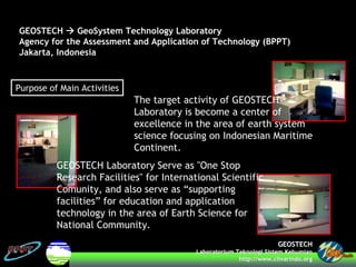
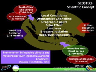
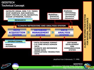
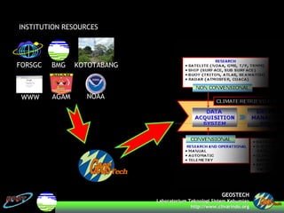
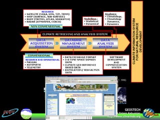
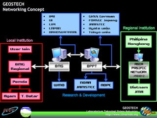
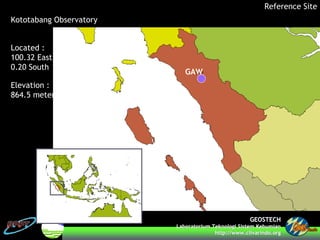
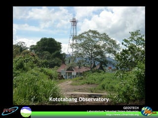
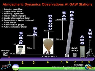
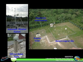
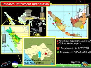
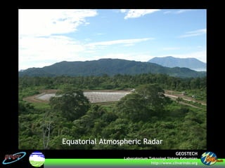
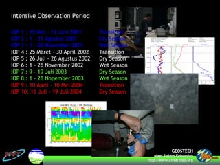
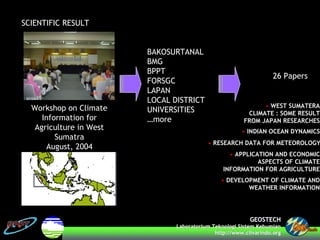
GEOSTECHGEOSTECH
LaboratoriumLaboratorium TeknologiTeknologi SistemSistem KebumianKebumian
http://www.http://www.clivarindoclivarindo.org.org
GEOSTECH LABORATORY ACTIVITIES RELATED TOGEOSTECH LABORATORY ACTIVITIES RELATED TO
CEOP REFERENCE SITECEOP REFERENCE SITE
Hongo Campus
University of Tokyo
28 February – 4 March 2005
M Sulchan Darmawan
msdarmawan@clivarindo.org
GEOSTECHGEOSTECH
LaboratoriumLaboratorium TeknologiTeknologi SistemSistem KebumianKebumian
http://www.http://www.clivarindoclivarindo.org.org
• Geostech Laboratory Overview
• Reference Site
• Instrumentations
• Intensive Observation Period
• Database Development (Archiving, Formatting, Analyzing)
• Scientific Result
GEOSTECHGEOSTECH
LaboratoriumLaboratorium TeknologiTeknologi SistemSistem KebumianKebumian
http://www.http://www.clivarindoclivarindo.org.org
The target activity of GEOSTECH
Laboratory is become a center of
excellence in the area of earth system
science focusing on Indonesian Maritime
Continent.
GEOSTECH Laboratory Serve as "One Stop
Research Facilities" for International Scientific
Comunity, and also serve as “supporting
facilities” for education and application
technology in the area of Earth Science for
National Community.
Purpose of Main Activities
GEOSTECH GeoSystem Technology Laboratory
Agency for the Assessment and Application of Technology (BPPT)
Jakarta, Indonesia
GEOSTECHGEOSTECH
LaboratoriumLaboratorium TeknologiTeknologi SistemSistem KebumianKebumian
http://www.http://www.clivarindoclivarindo.org.org
South China
Sea Surges
(7-10 days)
Local Conditions:
Orographicc Chanelling
Orographic uplift
Fohn Effect
Land-sea
Breeze-circulation
Haze/dust transport
Australian West
Coast surges
(7-10 days)
AUSTRALIAN MONSOON
(12 months)
40-50 day
Oscillation
(2-3 months)
ASIA MONSOON
(12 months)
El Nino
Shouthern
Oscilation
Phenomenon influencing climate and
meteorology over Indonesia Maritime
Continent.
(Adapted from McBride, 1992)
GEOSTECHGEOSTECH
Scientific ConceptScientific Concept
GEOSTECHGEOSTECH
LaboratoriumLaboratorium TeknologiTeknologi SistemSistem KebumianKebumian
http://www.http://www.clivarindoclivarindo.org.org
• SATELITE (NOAA, GMS, T/P, TRMM)
• SHIP (SURFACE, SUB SURFACE)
• BUOY (TRITON, ATLAS, SEAWATCH)
• RADAR (ATMOSFER, CUACA)
RESEARCH
• MANUAL
• AUTOMATIC
• DATA EXCHANGE FORMAT
• 3-D TIME-SPACE DOMAIN
DATA
• CLIMATE GEO REFERENCE
BASED DATA
• ASIMILATION/ REANALYSIS
DATA
Modelling :
• Statistical
• Dynamical
Analyses:
• Climatology,
• Climatology
Dynamics,
• Dynamics
CLIMATEINFORMATIONSYSTEM
FORNATURALRESOURCE
DEVELOPMENT
OPERATIONAL
SOFTWARE
DEVELOPMENT
AND
COMMUNICATION
SYSTEM
DATADATA
ACQUISITIONACQUISITION
SYSTEMSYSTEM
DATABASEDATABASE
MANAGEMENTMANAGEMENT
SYSTEMSYSTEM
DATADATA
ANALYSISANALYSIS
SYSTEMSYSTEM
CLIMATE RETRIEVING AND ANALYSIS SYSTEM
(Modified from Sribimawati, T. 1998)
GEOSTECHGEOSTECH
Technical ConceptTechnical Concept
GEOSTECHGEOSTECH
LaboratoriumLaboratorium TeknologiTeknologi SistemSistem KebumianKebumian
http://www.http://www.clivarindoclivarindo.org.org
KOTOTABANGBMGFORSGC
AGAMWWW
INSTITUTION RESOURCES
NOAA
GEOSTECHGEOSTECH
LaboratoriumLaboratorium TeknologiTeknologi SistemSistem KebumianKebumian
http://www.http://www.clivarindoclivarindo.org.org
GEOSTECHGEOSTECH
LaboratoriumLaboratorium TeknologiTeknologi SistemSistem KebumianKebumian
http://www.http://www.clivarindoclivarindo.org.org
GEOSTECHGEOSTECH
Networking ConceptNetworking Concept
GEOSTECHGEOSTECH
LaboratoriumLaboratorium TeknologiTeknologi SistemSistem KebumianKebumian
http://www.http://www.clivarindoclivarindo.org.org
Kototabang Observatory
Reference Site
GAW
Located :
100.32 East
0.20 South
Elevation :
864.5 meters
GEOSTECHGEOSTECH
LaboratoriumLaboratorium TeknologiTeknologi SistemSistem KebumianKebumian
http://www.http://www.clivarindoclivarindo.org.org
Kototabang ObservatoryKototabang Observatory
GEOSTECHGEOSTECH
LaboratoriumLaboratorium TeknologiTeknologi SistemSistem KebumianKebumian
http://www.http://www.clivarindoclivarindo.org.org
Atmospheric Dynamics Observations At GAW Stations
50 m
600 m
6000 m
500 m
30 km
2000 m
100 km
LAND SURFACE
stable
isotope
1 2 3 4 5 6 7 8
1. Boundary Layer Mast
2. Doppler Sonic Radar
3. Boundary Layer Radar
4. Radio Sonde (Campaign)
5. Equatorial Atmosphere Radar
6. Geopositioning System (moisture)
7. Stable Isotope
8. Automatic Rain gauges
9. Automatic Weather Station
Boundary
Layer
Mast
9
GEOSTECHGEOSTECH
LaboratoriumLaboratorium TeknologiTeknologi SistemSistem KebumianKebumian
http://www.http://www.clivarindoclivarindo.org.org
Doppler
Sodar Meteorological Obs
Automatic Weather
Station
GPS for Water
Vapor
Supersonic
Anemometer
GEOSTECHGEOSTECH
LaboratoriumLaboratorium TeknologiTeknologi SistemSistem KebumianKebumian
http://www.http://www.clivarindoclivarindo.org.org
A
B
C
D
E
F
G
A. DISDROMETER
B. RAIN GAUGE
C. AUTOMATIC WEATHER STATION
D. GPS for WATER VAPOUR
E. DOPPLER SODAR
F. SUPERSONIC ANEMOMETER
G. RADIO SONDE
GEOSTECHGEOSTECH
LaboratoriumLaboratorium TeknologiTeknologi SistemSistem KebumianKebumian
http://www.http://www.clivarindoclivarindo.org.org
Research Instrument DistributionResearch Instrument Distribution
Automatic Weather Station (AW
GPS for Water Vapour
Data transfer to GEOSTECH
AWSAWS GPSGPS
Disdrometer, SODAR, MRR, dll
SODARSODAR GPSGPS
MRRMRR
ARG
Manual Rain Gauge
Over Agam District
GEOSTECHGEOSTECH
LaboratoriumLaboratorium TeknologiTeknologi SistemSistem KebumianKebumian
http://www.http://www.clivarindoclivarindo.org.org
Equatorial Atmospheric RadarEquatorial Atmospheric Radar
GEOSTECHGEOSTECH
LaboratoriumLaboratorium TeknologiTeknologi SistemSistem KebumianKebumian
http://www.http://www.clivarindoclivarindo.org.org
Intensive Observation Period
IOP 1 : 15 Mei - 13 Juni 2001 Transition
IOP 2 : 1 - 31 Agustus 2001 Dry Season
IOP 3 : 1 - 28 November 2001 Wet Season
IOP 4 : 25 Maret - 30 April 2002 Transition
IOP 5 : 26 Juli - 26 Agustus 2002 Dry Season
IOP 6 : 1 - 28 November 2002 Wet Season
IOP 7 : 9 - 19 Juli 2003 Dry Season
IOP 8 : 1 - 28 Nopember 2003 Wet Season
IOP 9 : 10 April - 10 Mei 2004 Transition
IOP 10: 11 Juli - 19 Juli 2004 Dry Season
GEOSTECHGEOSTECH
LaboratoriumLaboratorium TeknologiTeknologi SistemSistem KebumianKebumian
http://www.http://www.clivarindoclivarindo.org.org
SCIENTIFIC RESULT
Workshop on Climate
Information for
Agriculture in West
Sumatra
August, 2004
BAKOSURTANAL
BMG
BPPT
FORSGC
LAPAN
LOCAL DISTRICT
UNIVERSITIES
…more
26 Papers
• WEST SUMATERA
CLIMATE : SOME RESULT
FROM JAPAN RESEARCHES
• INDIAN OCEAN DYNAMICS
• RESEARCH DATA FOR METEOROLOGY
• APPLICATION AND ECONOMIC
ASPECTS OF CLIMATE
INFORMATION FOR AGRICULTURE
• DEVELOPMENT OF CLIMATE AND
WEATHER INFORMATION
GEOSTECHGEOSTECH
LaboratoriumLaboratorium TeknologiTeknologi SistemSistem KebumianKebumian
http://www.http://www.clivarindoclivarindo.org.org
End Of Presentation

2.22_M_S_Darmawan

  • 1.
    GEOSTECHGEOSTECH LaboratoriumLaboratorium TeknologiTeknologi SistemSistemKebumianKebumian http://www.http://www.clivarindoclivarindo.org.org GEOSTECH LABORATORY ACTIVITIES RELATED TOGEOSTECH LABORATORY ACTIVITIES RELATED TO CEOP REFERENCE SITECEOP REFERENCE SITE Hongo Campus University of Tokyo 28 February – 4 March 2005 M Sulchan Darmawan msdarmawan@clivarindo.org
  • 2.
    GEOSTECHGEOSTECH LaboratoriumLaboratorium TeknologiTeknologi SistemSistemKebumianKebumian http://www.http://www.clivarindoclivarindo.org.org • Geostech Laboratory Overview • Reference Site • Instrumentations • Intensive Observation Period • Database Development (Archiving, Formatting, Analyzing) • Scientific Result
  • 3.
    GEOSTECHGEOSTECH LaboratoriumLaboratorium TeknologiTeknologi SistemSistemKebumianKebumian http://www.http://www.clivarindoclivarindo.org.org The target activity of GEOSTECH Laboratory is become a center of excellence in the area of earth system science focusing on Indonesian Maritime Continent. GEOSTECH Laboratory Serve as "One Stop Research Facilities" for International Scientific Comunity, and also serve as “supporting facilities” for education and application technology in the area of Earth Science for National Community. Purpose of Main Activities GEOSTECH GeoSystem Technology Laboratory Agency for the Assessment and Application of Technology (BPPT) Jakarta, Indonesia
  • 4.
    GEOSTECHGEOSTECH LaboratoriumLaboratorium TeknologiTeknologi SistemSistemKebumianKebumian http://www.http://www.clivarindoclivarindo.org.org South China Sea Surges (7-10 days) Local Conditions: Orographicc Chanelling Orographic uplift Fohn Effect Land-sea Breeze-circulation Haze/dust transport Australian West Coast surges (7-10 days) AUSTRALIAN MONSOON (12 months) 40-50 day Oscillation (2-3 months) ASIA MONSOON (12 months) El Nino Shouthern Oscilation Phenomenon influencing climate and meteorology over Indonesia Maritime Continent. (Adapted from McBride, 1992) GEOSTECHGEOSTECH Scientific ConceptScientific Concept
  • 5.
    GEOSTECHGEOSTECH LaboratoriumLaboratorium TeknologiTeknologi SistemSistemKebumianKebumian http://www.http://www.clivarindoclivarindo.org.org • SATELITE (NOAA, GMS, T/P, TRMM) • SHIP (SURFACE, SUB SURFACE) • BUOY (TRITON, ATLAS, SEAWATCH) • RADAR (ATMOSFER, CUACA) RESEARCH • MANUAL • AUTOMATIC • DATA EXCHANGE FORMAT • 3-D TIME-SPACE DOMAIN DATA • CLIMATE GEO REFERENCE BASED DATA • ASIMILATION/ REANALYSIS DATA Modelling : • Statistical • Dynamical Analyses: • Climatology, • Climatology Dynamics, • Dynamics CLIMATEINFORMATIONSYSTEM FORNATURALRESOURCE DEVELOPMENT OPERATIONAL SOFTWARE DEVELOPMENT AND COMMUNICATION SYSTEM DATADATA ACQUISITIONACQUISITION SYSTEMSYSTEM DATABASEDATABASE MANAGEMENTMANAGEMENT SYSTEMSYSTEM DATADATA ANALYSISANALYSIS SYSTEMSYSTEM CLIMATE RETRIEVING AND ANALYSIS SYSTEM (Modified from Sribimawati, T. 1998) GEOSTECHGEOSTECH Technical ConceptTechnical Concept
  • 6.
    GEOSTECHGEOSTECH LaboratoriumLaboratorium TeknologiTeknologi SistemSistemKebumianKebumian http://www.http://www.clivarindoclivarindo.org.org KOTOTABANGBMGFORSGC AGAMWWW INSTITUTION RESOURCES NOAA
  • 7.
    GEOSTECHGEOSTECH LaboratoriumLaboratorium TeknologiTeknologi SistemSistemKebumianKebumian http://www.http://www.clivarindoclivarindo.org.org
  • 8.
    GEOSTECHGEOSTECH LaboratoriumLaboratorium TeknologiTeknologi SistemSistemKebumianKebumian http://www.http://www.clivarindoclivarindo.org.org GEOSTECHGEOSTECH Networking ConceptNetworking Concept
  • 9.
    GEOSTECHGEOSTECH LaboratoriumLaboratorium TeknologiTeknologi SistemSistemKebumianKebumian http://www.http://www.clivarindoclivarindo.org.org Kototabang Observatory Reference Site GAW Located : 100.32 East 0.20 South Elevation : 864.5 meters
  • 10.
    GEOSTECHGEOSTECH LaboratoriumLaboratorium TeknologiTeknologi SistemSistemKebumianKebumian http://www.http://www.clivarindoclivarindo.org.org Kototabang ObservatoryKototabang Observatory
  • 11.
    GEOSTECHGEOSTECH LaboratoriumLaboratorium TeknologiTeknologi SistemSistemKebumianKebumian http://www.http://www.clivarindoclivarindo.org.org Atmospheric Dynamics Observations At GAW Stations 50 m 600 m 6000 m 500 m 30 km 2000 m 100 km LAND SURFACE stable isotope 1 2 3 4 5 6 7 8 1. Boundary Layer Mast 2. Doppler Sonic Radar 3. Boundary Layer Radar 4. Radio Sonde (Campaign) 5. Equatorial Atmosphere Radar 6. Geopositioning System (moisture) 7. Stable Isotope 8. Automatic Rain gauges 9. Automatic Weather Station Boundary Layer Mast 9
  • 12.
    GEOSTECHGEOSTECH LaboratoriumLaboratorium TeknologiTeknologi SistemSistemKebumianKebumian http://www.http://www.clivarindoclivarindo.org.org Doppler Sodar Meteorological Obs Automatic Weather Station GPS for Water Vapor Supersonic Anemometer
  • 13.
    GEOSTECHGEOSTECH LaboratoriumLaboratorium TeknologiTeknologi SistemSistemKebumianKebumian http://www.http://www.clivarindoclivarindo.org.org A B C D E F G A. DISDROMETER B. RAIN GAUGE C. AUTOMATIC WEATHER STATION D. GPS for WATER VAPOUR E. DOPPLER SODAR F. SUPERSONIC ANEMOMETER G. RADIO SONDE
  • 14.
    GEOSTECHGEOSTECH LaboratoriumLaboratorium TeknologiTeknologi SistemSistemKebumianKebumian http://www.http://www.clivarindoclivarindo.org.org Research Instrument DistributionResearch Instrument Distribution Automatic Weather Station (AW GPS for Water Vapour Data transfer to GEOSTECH AWSAWS GPSGPS Disdrometer, SODAR, MRR, dll SODARSODAR GPSGPS MRRMRR ARG Manual Rain Gauge Over Agam District
  • 15.
    GEOSTECHGEOSTECH LaboratoriumLaboratorium TeknologiTeknologi SistemSistemKebumianKebumian http://www.http://www.clivarindoclivarindo.org.org Equatorial Atmospheric RadarEquatorial Atmospheric Radar
  • 16.
    GEOSTECHGEOSTECH LaboratoriumLaboratorium TeknologiTeknologi SistemSistemKebumianKebumian http://www.http://www.clivarindoclivarindo.org.org Intensive Observation Period IOP 1 : 15 Mei - 13 Juni 2001 Transition IOP 2 : 1 - 31 Agustus 2001 Dry Season IOP 3 : 1 - 28 November 2001 Wet Season IOP 4 : 25 Maret - 30 April 2002 Transition IOP 5 : 26 Juli - 26 Agustus 2002 Dry Season IOP 6 : 1 - 28 November 2002 Wet Season IOP 7 : 9 - 19 Juli 2003 Dry Season IOP 8 : 1 - 28 Nopember 2003 Wet Season IOP 9 : 10 April - 10 Mei 2004 Transition IOP 10: 11 Juli - 19 Juli 2004 Dry Season
  • 17.
    GEOSTECHGEOSTECH LaboratoriumLaboratorium TeknologiTeknologi SistemSistemKebumianKebumian http://www.http://www.clivarindoclivarindo.org.org SCIENTIFIC RESULT Workshop on Climate Information for Agriculture in West Sumatra August, 2004 BAKOSURTANAL BMG BPPT FORSGC LAPAN LOCAL DISTRICT UNIVERSITIES …more 26 Papers • WEST SUMATERA CLIMATE : SOME RESULT FROM JAPAN RESEARCHES • INDIAN OCEAN DYNAMICS • RESEARCH DATA FOR METEOROLOGY • APPLICATION AND ECONOMIC ASPECTS OF CLIMATE INFORMATION FOR AGRICULTURE • DEVELOPMENT OF CLIMATE AND WEATHER INFORMATION
  • 18.
    GEOSTECHGEOSTECH LaboratoriumLaboratorium TeknologiTeknologi SistemSistemKebumianKebumian http://www.http://www.clivarindoclivarindo.org.org End Of Presentation