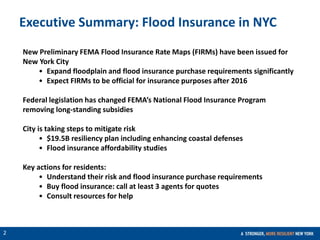
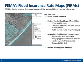
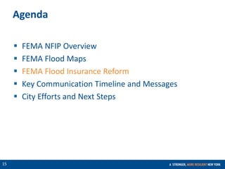
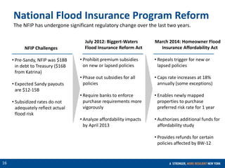
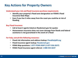
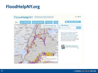
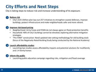
CONFIDENTIAL
1
FEMA Flood Maps and Flood Insurance
March 23, 2015
CONFIDENTIAL
2
Executive Summary: Flood Insurance in NYC
New Preliminary FEMA Flood Insurance Rate Maps (FIRMs) have been issued for
New York City
• Expand floodplain and flood insurance purchase requirements significantly
• Expect FIRMs to be official for insurance purposes after 2016
Federal legislation has changed FEMA’s National Flood Insurance Program
removing long-standing subsidies
City is taking steps to mitigate risk
• $19.5B resiliency plan including enhancing coastal defenses
• Flood insurance affordability studies
Key actions for residents:
• Understand their risk and flood insurance purchase requirements
• Buy flood insurance: call at least 3 agents for quotes
• Consult resources for help
CONFIDENTIAL
3
Agenda
 FEMA NFIP Overview
 FEMA Flood Maps
 FEMA Flood Insurance Reform
 Key Communication Timeline and Messages
 City Efforts and Next Steps
CONFIDENTIAL
4
The Biggert-
Waters Act
passes
History of Flood Insurance
National Flood
Insurance Program
created within HUD
Great Mississippi
Flood
New York City
adopts its first
Flood Insurance
Rate Map
Mandatory
Flood Insurance
Purchase
Requirement
Hurricane
Katrina hits
the Gulf Coast
The Homeowner
Flood Insurance
Affordability Act is
passed
Hurricane Sandy
hits the Northeast
1927
1968
1973
1983
2005 2014
2012
1979
FEMA
established and
NFIP moved from
HUD to FEMA
CONFIDENTIAL
5
FEMA’s National Flood Insurance Program
 Voluntary program based on a
mutual agreement between the
Federal government and the
local community:
 In exchange for adopting and
enforcing sound floodplain
management regulations and
mitigating risk, Federally-backed
flood insurance is made
available to property owners
and renters throughout the
community.
CONFIDENTIAL
6
FEMA’s National Flood Insurance Program
Program
Player Responsibility
Administers NFIP
Underwrites almost all
residential flood risk
Sample providers who sell
flood insurance policies and
manage claims as per
FEMA’s guidance
CONFIDENTIAL
7
Agenda
 FEMA NFIP Overview
 FEMA Flood Maps
 FEMA Flood Insurance Reform
 Key Communication Timeline and Messages
 City Efforts and Next Steps
CONFIDENTIAL
8
Key functions:
 Shows current flood risk
 Defines Special Flood Hazard Area (SFHA)
 VE, AE and AO zones
 “100-year floodplain” with 1% annual
chance of flood
(~26% chance over a 30-yr mortgage)
 Determines flood insurance requirements
 If you have a federally backed
mortgage or received federal disaster
assistance, including assistance
through Build it Back
 Informs building code standards
FEMA’s Flood Insurance Rate Maps (FIRMs)
FEMA’s flood maps are developed as part of the National Flood Insurance Program.
CONFIDENTIAL
9
FEMA 2007 Flood Insurance Rate Maps (FIRMs)
FEMA 2007 FIRMs 100-year Floodplain
Source: FEMA
Flood Insurance Rate Maps
Prior to Sandy, FEMA’s 2007 FIRMs were the best indicator of the city’s vulnerability to
flooding.
100-year Floodplain*
2007
FIRMs
Residents 218,000
Jobs 214,000
Buildings 36,000
1-4 Family 26,000
Floor Area
(Sq Ft.)
377M
 FIRMs not significantly updated
since 1983
 In 2007, digitized existing paper
maps, did not update accuracy
 1983 maps based on outdated
topography and weather data
* Numbers are rounded for clarity
CONFIDENTIAL
10
FEMA 2007 FIRMs 100-year Floodplain
Sandy Inundation Area (outside the 100-year Floodplain)
Source: FEMA
Damage outside 2007 100-year
floodplain:
• > 1/3 of red- and yellow-
tagged buildings
• ~ 1/2 of impacted residential
units
• > 1/2 of impacted buildings
Flood Insurance Rate Maps
Sandy demonstrated that New York was more vulnerable than previously thought.
FEMA 1983 FIRMs vs. Sandy Inundation Area
CONFIDENTIAL
11
100-year Floodplain*
2007
FIRMs
2013
PFIRMs
Change
(%)
Residents 218,000 400,000 83%
Jobs 214,000 290,800 35%
Buildings 36,000 71,500 99%
1-4 Family 26,000 53,000 104%
Floor Area
(Sq Ft.)
377M 532M 42%
FEMA 2013 Preliminary FIRMs 100-year Floodplain
FEMA 2007 FIRMs 100-year Floodplain
* Numbers are rounded for clarity
Flood Insurance Rate Maps
The most recent maps, called Preliminary FIRMs, were released in December 2013 and
show a floodplain that is 51% larger than previously.
FEMA 2007 FIRMs vs. Preliminary FIRMs
Homeowners with a federally-
backed mortgage in the 100-year
floodplain are required to buy
flood insurance
Source: FEMA
CONFIDENTIAL
12
Source: FEMA
FEMA 2013 Preliminary FIRMs 100-year Floodplain
Projected 2020s 100-year Floodplain
Projected 2050s 100-year Floodplain
Source: FEMA; CUNY Institute for Sustainable Cities
* Numbers are rounded for clarity
Flood Insurance Rate Maps
Given the City’s projections on sea level rise, these floodplains will extend even further by
the 2020s and into the 2050s.
Projected floodplain for the 2020s and 2050s 100-year Floodplain*
2013
PFIRMs
2050s
Projected
Change
(%)
Residents 400,000 801,000 100%
Jobs 290,800 555,700 91%
Buildings 71,500 114,000 59%
1-4 Family 53,000 84,000 104%
Floor Area
(Sq Ft.)
534M 855M 42%
CONFIDENTIAL
13
2009 - 2012 2013 2014
Comments and appeals
Final mapping
Preliminary Flood Insurance
Rate Maps (FIRMs) released
FIRM adopted
Activity
FEMA conducts regional
technical flood study
 www.region2coastal.com
 www.nyc.gov/floodmaps
Flood Insurance Rate Map Update
2015 2016
Insurance purchase requirements don’t take effect until maps are adopted
Today
CONFIDENTIAL
14
Appeals and Comments Process
Public review period of Flood Insurance Rate Maps
Comments Appeals
Location of municipal boundaries
Road name errors and revisions
Requests to incorporate Letters of Map
Change (LOMAs, LOMR-Fs and LOMRs)
Other possible omissions or potential
improvements to the maps
New or modified BFEs
Floodplain boundaries
SFHA zone designations
Accepted anytime 90-day statutory period
N/A
Must be based on scientific and
technical issues with FEMA
methodology and mapping
Must contain supporting data and
documentation
Timing
Requirements
What
submissions
can address
CONFIDENTIAL
15
Agenda
 FEMA NFIP Overview
 FEMA Flood Maps
 FEMA Flood Insurance Reform
 Key Communication Timeline and Messages
 City Efforts and Next Steps
CONFIDENTIAL
16
NFIP Challenges
• Pre-Sandy, NFIP was $18B
in debt to Treasury ($16B
from Katrina)
• Expected Sandy payouts
are $12-15B
• Subsidized rates do not
adequately reflect actual
flood risk
July 2012: Biggert-Waters
Flood Insurance Reform Act
• Prohibit premium subsidies
on new or lapsed policies
• Phase out subsidies for all
policies
• Require banks to enforce
purchase requirements more
vigorously
• Analyze affordability impacts
by April 2013
National Flood Insurance Program Reform
The NFIP has undergone significant regulatory change over the last two years.
March 2014: Homeowner Flood
Insurance Affordability Act
• Repeals trigger for new or
lapsed policies
• Caps rate increases at 18%
annually (some exceptions)
• Enables newly mapped
properties to purchase
preferred risk rate for 1 year
• Authorizes additional funds for
affordability study
• Provides refunds for certain
policies affected by BW-12
CONFIDENTIAL
17
$493
$581
$685Newly
Mapped
Current
Rate
National Flood Insurance Program Reform
NFIP Grandfathering for newly mapped
• When new maps become effective, current
subsidized rates will increase 18% per year upon
renewal (does not include new fees)
• Increases continue until premiums reach
projected Full Risk Rating X-zone rate
Projected Rate Cap
$452
$2,640
12 years
X Zone/A Zone
With basement
$808
CONFIDENTIAL
18
$493
$581
$685Current
Rate
Projected Rate Cap
$452
$2,640
12 years
$493
$581
$685
Newly
Mapped
Rate
$452
$7,800
17 years
PRP purchased before maps adopted –
grandfathered as “X” zone
Policy Purchased after maps adopted,
Newly Mapped in A Zone
National Flood Insurance Program Reform
Due to grandfathering, for those outside the current SFHA, benefit to purchasing a flood
policy before new maps are officially adopted.
Newly
Mapped
* Policy for X Zone rated, with basement in AE zone
Projected Rate Cap
Rate cap will
depend on
structure
elevation
CONFIDENTIAL
19
National Flood Insurance Program Reform
Rates increase based on building height relative to expected flood height. Home
elevation will reduce risk and premiums.
Rising Tides, Rising Costs, CNYCN
CONFIDENTIAL
20
NFIP Surcharges and Fees
Effective April 1, 2015
Policyholders must provide
proof their property is a
primary residence to avoid
excessive surcharges
CONFIDENTIAL
21
Agenda
 FEMA NFIP Overview
 FEMA Flood Maps
 FEMA Flood Insurance Reform
 Key Communication Timeline and Messages
 City Efforts and Next Steps
CONFIDENTIAL
22
Technical appeals
period is coming
Outreach Timeline Q4 2014 – 2017
Key Message
Dec 2014 July 2015April 2015Today 2017?
90-day statutory
appeals period
Final
mapping
FEMA flood maps are changing
You should buy flood insurance
You are legally
required to
buy flood
insurance
Flood risk is increasing
1. Community Coordination and Outreach (CCO) Meeting
City-led initiatives
Maps become official
FEMA-led initiatives
CONFIDENTIAL
23
Key Actions for Property Owners
Understand your risk and flood insurance purchase requirements
• Identify your property’s flood zone designation on FEMA’s Flood
Insurance Rate Maps
• Even if you live 2 miles away from the coast you could be at risk of
flooding
Buy Flood Insurance
• Call at least 3 agents listed on floodsmart.gov for quotes
• Homeowners insurance does not cover damage from floods and federal
assistance is not guaranteed in the event of a flood
For help, consult the following resources:
• Flood risk information and address lookup: FloodHelpNY.org
• Flood insurance agent lookup: floodsmart.gov
• FEMA Map questions: 1-877-FEMA MAP (1-877-336-2627)
• FEMA Flood Insurance agent referral: 1-888-435-6637
CONFIDENTIAL
24
FloodHelpNY.org
CONFIDENTIAL
25
Agenda
 FEMA NFIP Overview
 FEMA Flood Maps
 FEMA Flood Insurance Reform
 Key Actions for Property Owners
 City Efforts and Next Steps
CONFIDENTIAL
26
Reduce risk
• City’s $19.5 Billion plan lays out 257 initiatives to strengthen coastal defenses, improve
buildings, protect infrastructure and make neighborhoods safer and more vibrant
Improve risk-based pricing
• Neighborhood: Army Corps and FEMA do not always agree on flood protection benefits
• Household: 40% of City’s buildings cannot be elevated; exploring alternative mitigation
strategies
• “Pre-FIRM” construction: Need updated rate-setting methodology for old building stock
(focus of the Negatively-Rated Building Study being conducted by the National Academy)
Launch affordability studies
• Launching two studies assess affordability impacts and potential solutions for multifamily
and 1-4 family homes
Inform the public
• Launching public education campaign regarding risks, mitigation and flood coverage
1
2
3
4
City Efforts and Next Steps
City is taking steps to reduce risk and increase understanding of its exposure.
CONFIDENTIAL
27
nyc.gov/resiliency
@Planyc

Executive Summary: Flood Insurance in NYC

  • 1.
    CONFIDENTIAL 1 FEMA Flood Mapsand Flood Insurance March 23, 2015
  • 2.
    CONFIDENTIAL 2 Executive Summary: FloodInsurance in NYC New Preliminary FEMA Flood Insurance Rate Maps (FIRMs) have been issued for New York City • Expand floodplain and flood insurance purchase requirements significantly • Expect FIRMs to be official for insurance purposes after 2016 Federal legislation has changed FEMA’s National Flood Insurance Program removing long-standing subsidies City is taking steps to mitigate risk • $19.5B resiliency plan including enhancing coastal defenses • Flood insurance affordability studies Key actions for residents: • Understand their risk and flood insurance purchase requirements • Buy flood insurance: call at least 3 agents for quotes • Consult resources for help
  • 3.
    CONFIDENTIAL 3 Agenda  FEMA NFIPOverview  FEMA Flood Maps  FEMA Flood Insurance Reform  Key Communication Timeline and Messages  City Efforts and Next Steps
  • 4.
    CONFIDENTIAL 4 The Biggert- Waters Act passes Historyof Flood Insurance National Flood Insurance Program created within HUD Great Mississippi Flood New York City adopts its first Flood Insurance Rate Map Mandatory Flood Insurance Purchase Requirement Hurricane Katrina hits the Gulf Coast The Homeowner Flood Insurance Affordability Act is passed Hurricane Sandy hits the Northeast 1927 1968 1973 1983 2005 2014 2012 1979 FEMA established and NFIP moved from HUD to FEMA
  • 5.
    CONFIDENTIAL 5 FEMA’s National FloodInsurance Program  Voluntary program based on a mutual agreement between the Federal government and the local community:  In exchange for adopting and enforcing sound floodplain management regulations and mitigating risk, Federally-backed flood insurance is made available to property owners and renters throughout the community.
  • 6.
    CONFIDENTIAL 6 FEMA’s National FloodInsurance Program Program Player Responsibility Administers NFIP Underwrites almost all residential flood risk Sample providers who sell flood insurance policies and manage claims as per FEMA’s guidance
  • 7.
    CONFIDENTIAL 7 Agenda  FEMA NFIPOverview  FEMA Flood Maps  FEMA Flood Insurance Reform  Key Communication Timeline and Messages  City Efforts and Next Steps
  • 8.
    CONFIDENTIAL 8 Key functions:  Showscurrent flood risk  Defines Special Flood Hazard Area (SFHA)  VE, AE and AO zones  “100-year floodplain” with 1% annual chance of flood (~26% chance over a 30-yr mortgage)  Determines flood insurance requirements  If you have a federally backed mortgage or received federal disaster assistance, including assistance through Build it Back  Informs building code standards FEMA’s Flood Insurance Rate Maps (FIRMs) FEMA’s flood maps are developed as part of the National Flood Insurance Program.
  • 9.
    CONFIDENTIAL 9 FEMA 2007 FloodInsurance Rate Maps (FIRMs) FEMA 2007 FIRMs 100-year Floodplain Source: FEMA Flood Insurance Rate Maps Prior to Sandy, FEMA’s 2007 FIRMs were the best indicator of the city’s vulnerability to flooding. 100-year Floodplain* 2007 FIRMs Residents 218,000 Jobs 214,000 Buildings 36,000 1-4 Family 26,000 Floor Area (Sq Ft.) 377M  FIRMs not significantly updated since 1983  In 2007, digitized existing paper maps, did not update accuracy  1983 maps based on outdated topography and weather data * Numbers are rounded for clarity
  • 10.
    CONFIDENTIAL 10 FEMA 2007 FIRMs100-year Floodplain Sandy Inundation Area (outside the 100-year Floodplain) Source: FEMA Damage outside 2007 100-year floodplain: • > 1/3 of red- and yellow- tagged buildings • ~ 1/2 of impacted residential units • > 1/2 of impacted buildings Flood Insurance Rate Maps Sandy demonstrated that New York was more vulnerable than previously thought. FEMA 1983 FIRMs vs. Sandy Inundation Area
  • 11.
    CONFIDENTIAL 11 100-year Floodplain* 2007 FIRMs 2013 PFIRMs Change (%) Residents 218,000400,000 83% Jobs 214,000 290,800 35% Buildings 36,000 71,500 99% 1-4 Family 26,000 53,000 104% Floor Area (Sq Ft.) 377M 532M 42% FEMA 2013 Preliminary FIRMs 100-year Floodplain FEMA 2007 FIRMs 100-year Floodplain * Numbers are rounded for clarity Flood Insurance Rate Maps The most recent maps, called Preliminary FIRMs, were released in December 2013 and show a floodplain that is 51% larger than previously. FEMA 2007 FIRMs vs. Preliminary FIRMs Homeowners with a federally- backed mortgage in the 100-year floodplain are required to buy flood insurance Source: FEMA
  • 12.
    CONFIDENTIAL 12 Source: FEMA FEMA 2013Preliminary FIRMs 100-year Floodplain Projected 2020s 100-year Floodplain Projected 2050s 100-year Floodplain Source: FEMA; CUNY Institute for Sustainable Cities * Numbers are rounded for clarity Flood Insurance Rate Maps Given the City’s projections on sea level rise, these floodplains will extend even further by the 2020s and into the 2050s. Projected floodplain for the 2020s and 2050s 100-year Floodplain* 2013 PFIRMs 2050s Projected Change (%) Residents 400,000 801,000 100% Jobs 290,800 555,700 91% Buildings 71,500 114,000 59% 1-4 Family 53,000 84,000 104% Floor Area (Sq Ft.) 534M 855M 42%
  • 13.
    CONFIDENTIAL 13 2009 - 20122013 2014 Comments and appeals Final mapping Preliminary Flood Insurance Rate Maps (FIRMs) released FIRM adopted Activity FEMA conducts regional technical flood study  www.region2coastal.com  www.nyc.gov/floodmaps Flood Insurance Rate Map Update 2015 2016 Insurance purchase requirements don’t take effect until maps are adopted Today
  • 14.
    CONFIDENTIAL 14 Appeals and CommentsProcess Public review period of Flood Insurance Rate Maps Comments Appeals Location of municipal boundaries Road name errors and revisions Requests to incorporate Letters of Map Change (LOMAs, LOMR-Fs and LOMRs) Other possible omissions or potential improvements to the maps New or modified BFEs Floodplain boundaries SFHA zone designations Accepted anytime 90-day statutory period N/A Must be based on scientific and technical issues with FEMA methodology and mapping Must contain supporting data and documentation Timing Requirements What submissions can address
  • 15.
    CONFIDENTIAL 15 Agenda  FEMA NFIPOverview  FEMA Flood Maps  FEMA Flood Insurance Reform  Key Communication Timeline and Messages  City Efforts and Next Steps
  • 16.
    CONFIDENTIAL 16 NFIP Challenges • Pre-Sandy,NFIP was $18B in debt to Treasury ($16B from Katrina) • Expected Sandy payouts are $12-15B • Subsidized rates do not adequately reflect actual flood risk July 2012: Biggert-Waters Flood Insurance Reform Act • Prohibit premium subsidies on new or lapsed policies • Phase out subsidies for all policies • Require banks to enforce purchase requirements more vigorously • Analyze affordability impacts by April 2013 National Flood Insurance Program Reform The NFIP has undergone significant regulatory change over the last two years. March 2014: Homeowner Flood Insurance Affordability Act • Repeals trigger for new or lapsed policies • Caps rate increases at 18% annually (some exceptions) • Enables newly mapped properties to purchase preferred risk rate for 1 year • Authorizes additional funds for affordability study • Provides refunds for certain policies affected by BW-12
  • 17.
    CONFIDENTIAL 17 $493 $581 $685Newly Mapped Current Rate National Flood InsuranceProgram Reform NFIP Grandfathering for newly mapped • When new maps become effective, current subsidized rates will increase 18% per year upon renewal (does not include new fees) • Increases continue until premiums reach projected Full Risk Rating X-zone rate Projected Rate Cap $452 $2,640 12 years X Zone/A Zone With basement $808
  • 18.
    CONFIDENTIAL 18 $493 $581 $685Current Rate Projected Rate Cap $452 $2,640 12years $493 $581 $685 Newly Mapped Rate $452 $7,800 17 years PRP purchased before maps adopted – grandfathered as “X” zone Policy Purchased after maps adopted, Newly Mapped in A Zone National Flood Insurance Program Reform Due to grandfathering, for those outside the current SFHA, benefit to purchasing a flood policy before new maps are officially adopted. Newly Mapped * Policy for X Zone rated, with basement in AE zone Projected Rate Cap Rate cap will depend on structure elevation
  • 19.
    CONFIDENTIAL 19 National Flood InsuranceProgram Reform Rates increase based on building height relative to expected flood height. Home elevation will reduce risk and premiums. Rising Tides, Rising Costs, CNYCN
  • 20.
    CONFIDENTIAL 20 NFIP Surcharges andFees Effective April 1, 2015 Policyholders must provide proof their property is a primary residence to avoid excessive surcharges
  • 21.
    CONFIDENTIAL 21 Agenda  FEMA NFIPOverview  FEMA Flood Maps  FEMA Flood Insurance Reform  Key Communication Timeline and Messages  City Efforts and Next Steps
  • 22.
    CONFIDENTIAL 22 Technical appeals period iscoming Outreach Timeline Q4 2014 – 2017 Key Message Dec 2014 July 2015April 2015Today 2017? 90-day statutory appeals period Final mapping FEMA flood maps are changing You should buy flood insurance You are legally required to buy flood insurance Flood risk is increasing 1. Community Coordination and Outreach (CCO) Meeting City-led initiatives Maps become official FEMA-led initiatives
  • 23.
    CONFIDENTIAL 23 Key Actions forProperty Owners Understand your risk and flood insurance purchase requirements • Identify your property’s flood zone designation on FEMA’s Flood Insurance Rate Maps • Even if you live 2 miles away from the coast you could be at risk of flooding Buy Flood Insurance • Call at least 3 agents listed on floodsmart.gov for quotes • Homeowners insurance does not cover damage from floods and federal assistance is not guaranteed in the event of a flood For help, consult the following resources: • Flood risk information and address lookup: FloodHelpNY.org • Flood insurance agent lookup: floodsmart.gov • FEMA Map questions: 1-877-FEMA MAP (1-877-336-2627) • FEMA Flood Insurance agent referral: 1-888-435-6637
  • 24.
  • 25.
    CONFIDENTIAL 25 Agenda  FEMA NFIPOverview  FEMA Flood Maps  FEMA Flood Insurance Reform  Key Actions for Property Owners  City Efforts and Next Steps
  • 26.
    CONFIDENTIAL 26 Reduce risk • City’s$19.5 Billion plan lays out 257 initiatives to strengthen coastal defenses, improve buildings, protect infrastructure and make neighborhoods safer and more vibrant Improve risk-based pricing • Neighborhood: Army Corps and FEMA do not always agree on flood protection benefits • Household: 40% of City’s buildings cannot be elevated; exploring alternative mitigation strategies • “Pre-FIRM” construction: Need updated rate-setting methodology for old building stock (focus of the Negatively-Rated Building Study being conducted by the National Academy) Launch affordability studies • Launching two studies assess affordability impacts and potential solutions for multifamily and 1-4 family homes Inform the public • Launching public education campaign regarding risks, mitigation and flood coverage 1 2 3 4 City Efforts and Next Steps City is taking steps to reduce risk and increase understanding of its exposure.
  • 27.